| | -
-
| |  |
|
6 |
-
-
-
-
-
-
| |  |
|
1 |
-
-
|
| | |
|
| Hiking | 6.40 Miles |
2,500 AEG |
| | Hiking | 6.40 Miles | 5 Hrs | | 1.28 mph |
| 2,500 ft AEG | | | | |
|
|
| |
| Linked |
|
none
[ show ]
| no linked trail guides |
| Partners |
|
[ show ]
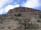
| partners | | Did this from Leisure Trailhead to the ruins and back. It is a steady climb up about 2500 feet that doesn't really pause and let you catch your breath. Cherry Creek is flowing really well, all the rocks you could use to hop across were submerged. The final 500 foot climb up to the ruins is quite a steep scramble, but other than the height, it's not as tough or dangerous as say, the climb up to Devil's Chasm ruins. The trail was in pretty good condition, there was a little overgrowth in the Cherry Creek floodplane. It's not a maintained trail, but it's better than most non-touron-Supes trails, it was a little mysterious which way to go in places, though.
Pretty nice weather, hot on the way up, cool on the way down, but some rainclouds appeared to be starting to roll in as we were heading home.
I fixed the trailhead sign, made a bunch of cairns, and created a few lines of rocks to keep you off splinter trails in my spare time, hope it helps someone.
PS, there is a gate in the fenceline on the other side of Cherry Creek. If you get to the fence and find a spot people have scrambled up under the barbed wire, head southwest (hiker's left) about 150 yards to find the gate.
The ruins mentioned make my top 5 list so far. I also spotted some other ruins not mentioned, the area is overflowing with them. I'll have to return someday to check them out and do the full shuttle trip starting from Ranger Red's cabin. |
| _____________________
http://hikearizona.com/garmin_maps.php
Hike Arizona it is full of sharp, pointy, ankle-twisting, HAZmaster crushing ROCKS!!
Hike Arizona it is full of sharp, pointy, shin-stabbing, skin-shredding plants!
Hike Arizona it is full of striking, biting, stabbing, venomous wildlife! |
| | |
|
|
|
|
|
| |
 Route Editor


