| |
| Gleason Flat Salt River via FR303B, AZ | | -
-
| 3 labels | 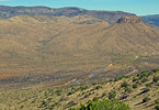 |
|
|
-
-
| 3 labels | 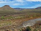 |
|
|
-
| |  |
|
2 |
-
-
-
-
| 1 label |  |
|
|
-
-
-
-
|
| | Gleason Flat Salt River via FR303B, AZ | | | |
|
|
Gleason Flat Salt River via FR303B, AZ
| | |
|
| Hiking | 4.10 Miles |
601 AEG |
| | Hiking | 4.10 Miles | 3 Hrs 45 Mns | | 1.82 mph |
| 601 ft AEG | 1 Hour 30 Mns Break | | | |
|
|
| |
| Partners |
|
[ show ]
| partners | | This was our planned hike number 2 of 3 on a 4nt/5day vehicle camping-hiking trip to this remote, less hiked section of the Tonto National Forest off Hwy 60N of Globe bordering the Salt River Canyon Wilderness off Haystack Butte Road FR303.
Today we were looking forward to some easier hiking and a change of scenery from our previous day's more demanding off-trail hike to summit Peak 5255- Mule Hoof Bend Quad.
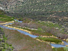
Originally we had plans to drive my semi-stock 4WD Toyota 4Runner the entire length of FR303B down to the Salt River and continue on for a distance before planning some hike exploring of the river front areas but about 1/2 mile from the river heading downhill on FR303B, it became obviously apparant to me that "driving it" was not going to be safely possible in my vehicle. Not a problem, as we would just hike this additional out and back distance instead of driving it. I'm just grateful that I realized the need to stop and park it when I did or it could have been a very bad ending scene!
Overall, this out and back hike (no loop this time  ) offered very scenic views and a lot of historic miming and old ranching history (see Oregon_Hiker's triplog for that interesting detail). I particularly enjoyed the views of the Salt River, the near and distant views across the river of Gleason Flat, the huge White Mtn Apache Indian Reservation Land, and most of all enjoyed our ending, secluded Salt River destination for a most pleasant lunch break (for this area see my picset pics 5-9). ) offered very scenic views and a lot of historic miming and old ranching history (see Oregon_Hiker's triplog for that interesting detail). I particularly enjoyed the views of the Salt River, the near and distant views across the river of Gleason Flat, the huge White Mtn Apache Indian Reservation Land, and most of all enjoyed our ending, secluded Salt River destination for a most pleasant lunch break (for this area see my picset pics 5-9).
|
| _____________________
| (Outside.. "there is No Place Like It!!") |
| | |
|
|
|
|
|
| |
 Route Editor


