| | -
-
-
| 1 label | 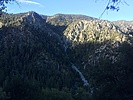 |
|
|
-
| 1 label | 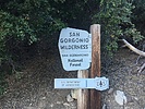 |
|
|
-
| 1 label | 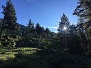 |
|
|
-
-
-
| 1 label | 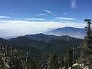 |
|
|
-
-
-
| 1 label | 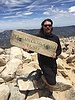 |
|
1 |
-
-
| 2 labels | 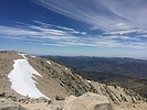 |
|
|
|
| | |
|
| Hiking | 18.84 Miles |
5,400 AEG |
| | Hiking | 18.84 Miles | 10 Hrs 42 Mns | | 2.07 mph |
| 5,400 ft AEG | 1 Hour 35 Mns Break | | | |
|
|
| |
| Linked |
|
none
[ show ]
| no linked trail guides |
| Partners |
|
none
[ show ]
| no partners | | I heard about this one from a friend of mine that lives in California. A week long family vacation to San Diego had a free day for me to get away so I decided to go to the top of Southern California! This was a very beautiful and challenging hike. Even the drive in was scenic. The parking lot still had several spots available at 6:30AM, but there was no one in the Kiosk to buy an Adventure Pass Parking Pass and the Elkhorn store was closed, so I left a note on the windshield instead and NO TICKET!  . .
The bugs were ferocious. After crossing the Mill Creek, and this thing was massive, the hike goes on a pretty steady incline up 1000 ft or so for a little over a mile. I felt it was pretty mild compared to what I have read about. The first camp was right around the corner from there and there were several deer that first were being stubborn about getting off the trail and out of the way and then followed me on the trail for another 1000 feet. Water stops were brief as the mosquitoes had acquired a strong thirst for my blood at that point. The next section of the hike was just stunning. There were huge pines and spruce and firs that towered above the rock formations covered in bright green ferns and other foliage. Then there were giant mountain tops and ridgelines above all that. It was one of the most majestic places I have ever been to. I really felt a great sense of gratitude to be there (and all alone!) at that time. After several miles and another 1000ft gain, I reached High Creek Camp. I stopped here for a short break and water fill for the final push. After High Creek, the switchbacks were relentless and brutal. I slowed down quite a bit after I hit 11k. Took a short rest just above the tree line and the sunshine felt so great up there. Made the final push to the summit through some cool areas with quite a bit of snow still left up there. Rested at the top and chatted with locals for a good 40 minutes before I headed back down. I felt great and was making a speedy pace, but my knees had other thoughts, so it was a slow and methodical decent instead. It took me just about 6 hours to summit and about 4 to get down. That includes many breaks going up and 15 minutes to fix my camelback tube. I was very impressed with myself and my pace and my California friend also was impressed that I tried to tackle this all in one day. There were far less people up there that I was expecting. Most people were just day hiking the mountain, but there were several groups of campers soaking up a few days. I would love to spend more time in this area. I will make sure to bring the bug spray. |
| _____________________
| “There is nothing that exists outside the thought of the immediate moment.” |
| | |
|
|
|
|
|
| |
 Route Editor


