| | -
-
-
| 1 label |  |
|
|
-
-
-
-
-
| 5 labels |  |
|
|
-
| 1 label |  |
|
|
-
-
| 3 labels |  |
|
|
-
| 1 label | 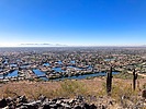 |
|
2 |
-
| 1 label |  |
|
|
|
| | |
|
| Hiking | 6.50 Miles |
959 AEG |
| | Hiking | 6.50 Miles | 2 Hrs 30 Mns | | 2.60 mph |
| 959 ft AEG | | | | |
|
|
| |
| Partners |
|
none
[ show ]
| no partners | | Starting from the pullout on 51st Ave., I hiked a clockwise lasso of Coachwhip Trail and Arrowhead Point Trail. It is typical Maricopa County suburban hiking: rolling desert. Not easily bike-able due to rockiness. High-end housing less than a hundred yards away. (Average home price over $800k.) 
According to eBird, 130 avian species have been spotted in the park. The most common water species being ... uhh ... common merganser. Plus ruddy duck, ring-necked duck, lesser scaup and double-crested cormorant.
The parking on Pinnacle Peak Rd. is definitely the more popular parking option. Many hikers and dog walkers were doing an up & down, or short lasso, both of which are about 2.4 mi., 460 ft.
Clockwise, Arrowhead Point Trail climbs 270 ft., is relatively flat for 200 yds., then climbs a short — but steeper — 120 ft. to the summit. Both climbs are very rocky, with multiple step-ups. The summit had Old Glory, a couple stools built of rock slab resting on gabions, and no shade.
The descent back to the 59th Ave. bridge is 400 ft. It’s steeper still than the way I climbed, but with smoother surface. I jogged much of it. On the way down, I realized my bottle of water bottle had disappeared. It was getting toasty. Luckily, I sill had some water in my Camelbak.
I didn’t jog as much back along Coachwhip Trail, but still made good time, finishing the 2.6 miles in only 56 minutes. (Not counting a bird blind pit stop.)
Rumble Video: https://rumble.com/v5q8q6t-hiking-thund ... -park.html
Vimeo Video: https://vimeo.com/1030475901 |
|
Wildflowers Observation None
Zilch. |
|
| _____________________
| http://prestonm.com : Everyone's enjoyment of the outdoors is different and should be equally honored. |
| | |
|
|
|
|
|
| |
 Route Editor


