username
X
password
register
for free!
help
ArticlesGuidesRoutes
 
Photosets
 
 Comments
triplogs   photosets   labels comments more
Usery Rd to Meridian - 5 members in 15 triplogs have rated this an average 2.8 ( 1 to 5 best )
15 triplogs
login for filter options
Sep 02 2024
avatar

 Guides 59
 Routes 1,100
 Photos 1,191
 Triplogs 1,290

male
 Joined Jan 01 2023
 Arizona
Pass Mtn Ridgeline Loop - Meridian THPhoenix, AZ
Phoenix, AZ
Hiking avatar Sep 02 2024
pseudalpineTriplogs 1,290
Hiking9.86 Miles 2,206 AEG
Hiking9.86 Miles   3 Hrs   29 Mns   3.02 mph
2,206 ft AEG      13 Mns Break
 
no photosets
1st trip
Route Scout Route Recorded  on Route Scout | Pop | Map | Popup | MapDEX
  1 archive
Aug 07 2024
avatar

 Guides 69
 Routes 37
 Photos 3,010
 Triplogs 2,387

55 male
 Joined Oct 24 2010
 Phoenix,Az
Usery Rd to MeridianPhoenix, AZ
Phoenix, AZ
Hiking avatar Aug 07 2024
mt98dewTriplogs 2,387
Hiking10.09 Miles 524 AEG
Hiking10.09 Miles   3 Hrs   4 Mns   3.29 mph
524 ft AEG
 no routes
Linked   none no linked trail guides
Partners none no partners
Early morning hike at Usery. It’s been awhile since I’ve done Pass Mountain loop. Thought I would do that and add on the Meridian and Usery “tails”. Parked at the Meridian TH and was on the trail by 5am. Did the loop CCW. Little dark at first, but lightened up within 20 minutes. I was hoping for another spectacular sunrise, but the trail did not lend itself to ideal viewing conditions. Still a pleasant morning with a decent breeze to start the hike (and temps were in the 80’s :o ). There are two opportunities to connect to Usery. One is marked as the Maricopa Trail. The other is marked as the Talon Trail. I did the Talon as an out and back and then continued CCW on the Pass Mountain. Pretty quiet trails. 5 hikers and 3 bikers. Did see a Javelina early in the hike :)
_____________________
 
Apr 19 2020
avatar

 Guides 1
 Routes 447
 Photos 4,407
 Triplogs 938

68 male
 Joined Mar 09 2012
 Gilbert, AZ
Pass Mountain Pass, AZ 
Pass Mountain Pass, AZ
 
Hiking avatar Apr 19 2020
rayhustonTriplogs 938
Hiking6.26 Miles 837 AEG
Hiking6.26 Miles   2 Hrs   24 Mns   2.61 mph
837 ft AEG
 
Partners none no partners
Route Scout Route Recorded  on Route Scout | Pop | Map | Popup | MapDEX
Out for some exercise on a beautiful morning. I started at a cutout on Usery Rd and followed the well used trail to the Maricopa Trail segment and followed that to the Pass Mon Loop trail. I followed the loop in a clockwise direction to the Pass.

This was going to be my turn around point but I wanted A little more so I went down the hill on the Peak 3004 Loop trail. When I reached the bottom of the ravine, I turned around and headed back. I was tired in the last half mile of the hike so that little extra turned out to be enough.

A little bit of haze in the distance but not a cloud in the sky. Tons of people out. It was awkward trying to provide enough room on the single track trail. I was trying to push it a little but couldn't really, not with so many people out in this new era of social distancing.

Enjoyable nonetheless.
_____________________
 
Oct 19 2018
avatar

 Guides 2
 Routes 25
 Photos 1,890
 Triplogs 604

41 male
 Joined Sep 13 2009
 Mesa, AZ
Usery Rd to MeridianPhoenix, AZ
Phoenix, AZ
Hiking avatar Oct 19 2018
jochalTriplogs 604
Hiking5.00 Miles 600 AEG
Hiking5.00 Miles
600 ft AEG
 no routesno photosets
Linked   none no linked trail guides
Partners none no partners
Only went from Usery Rd. to Saddle and back.
_____________________
 
Apr 27 2017
avatar

 Guides 6
 Routes 23
 Photos 1,125
 Triplogs 593

46 male
 Joined May 23 2012
 Mesa, AZ
Pass Mountain RidgelinePhoenix, AZ
Phoenix, AZ
Hiking avatar Apr 27 2017
syoungTriplogs 593
Hiking8.13 Miles 1,926 AEG
Hiking8.13 Miles   2 Hrs   28 Mns   3.30 mph
1,926 ft AEG
 no routes
I have been wanting to get this one checked off for awhile now. I headed to the Usery Rd trailhead and made my way towards the mountain. The other day, I shot up to the Wind Cave from here in a really quick fashion. I felt horrible upon reaching the cave however. Today I took it slow on the ascent there.

Upon passing the cave I traveled about a hundred yards or so and just decided to head straight up from there. It is the most common area that I tend to come down from when descending from Peak 3127. I typically blaze a path upwards towards this peak that is different each time. I forgo the switchbacks and the confusion and it was nice.

I changed into my approach shoes at this point and proceeded onto the ridgeline. The first few up and downs were kind of gnarly in that I was expecting to see at least something that resembles a trail; nope. Cruising up here is just not possible. Ankle busting rocks are hidden by tall grass. This also leads you to not getting to fully enjoy the views unless you come to a complete stop.

As I dotted my way across the ridge the going was very slow. I just wasn't mentally prepared for this kind of slog after a long day at school. And this led directly to me turning this hike into a hellish beast on the descent from the ridgeline. Apparently, I was due east from the gps track of the descent. I was well in a drainage before I realized my error. When I checked to see where I was, compared to the track I had loaded, it was just easier to stay in. The drainage was hard and the most overgrown section of real estate I have ever tread through. I'll be pulling various deceased plant life from my skin over the next several days. On this particular path there was also a couple tricky down climbs. This section was .4 miles in length and took 28:56 to descend 561 feet. My average moving pace through there was .77 MPH..er what? That is definitely not my cup of tea.
_____________________
 
Mar 06 2017
avatar

 Guides 6
 Routes 23
 Photos 1,125
 Triplogs 593

46 male
 Joined May 23 2012
 Mesa, AZ
Usery Rd to MeridianPhoenix, AZ
Phoenix, AZ
Hiking avatar Mar 06 2017
syoungTriplogs 593
Hiking5.74 Miles 774 AEG
Hiking5.74 Miles   1 Hour   18 Mns   4.42 mph
774 ft AEG
 
no photosets
1st trip
Partners none no partners
The views are pretty incredible along the way. I had never made it out in this direction. It really looks like a mini Monument Valley. The pyramid shaped peak really piqued my interest. Looks like I should plan a trip into the Goldfields. Took some long breaks just to enjoy the views. For such a short jaunt you get that isolated feeling quite quickly out here.
_____________________
  1 archive
Feb 21 2015
avatar

 Guides 41
 Routes 1,626
 Photos 14,983
 Triplogs 2,760

69 male
 Joined Jan 20 2009
 Far NE Phoenix,
Pass Wind Ridgeline, AZ 
Pass Wind Ridgeline, AZ
 
Hiking avatar Feb 21 2015
The_EagleTriplogs 2,760
Hiking8.19 Miles 2,192 AEG
Hiking8.19 Miles   3 Hrs   40 Mns   2.47 mph
2,192 ft AEG      21 Mns Break14 LBS Pack
 
1st trip
Partners partners
johnlp
lil_tortoise_hiker
Tortoise_Hiker
A fun little in town hike with the Turtle boys and LP. I'd been to the Wind Cave a long time ago, but that was it for this area for me.

Denny decided on the hike and it got revised as we went.
Lil-D (Congrats!) always loves hiking with me and now JohnLP has made his list.

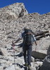
We started at the no pay TH on Usery Pass Rd a little after 6:30 and went CCW on the Pass Mountain Loop Trail to the Wind Cave Trail. We passed a couple of groups.

We saw a few more groups on our way up the Wind Cave Trail and headed past the Wind cave for Peak 3126. Next we had the Ridgeline to ourselves. The spot we dropped down, looked thick and brushy from above, but it was relatively easy to select a path. Going down the Backside, was Denny's favorite part of he hike.

We hit the Pass Mountain Loop trail again and it was clear sailing back to the car.

Lots of people out enjoying the day. There was plenty of poppin' poppies, Brittlebush, Lupine, and a bit of Desert Chicory were also blooming.

youtu.be/Uw1eZecs3HM

Congrats Denny on a 4th DOTY Award!
wildflower observationwildflower observationwildflower observationwildflower observationwildflower observation
Wildflowers Observation Moderate
Poppys, Brittlebush, Lupine, Desert Chicory, Fairy Duster
_____________________
There is a very fine line between "hobby" and "mental illness."
Dave Barry 🦅
 
Feb 21 2015
avatar

 Guides 1
 Routes 14
 Photos 7,202
 Triplogs 5,208

68 male
 Joined Mar 16 2008
 chandler,az
Pass Wind Ridgeline, AZ 
Pass Wind Ridgeline, AZ
 
Hiking avatar Feb 21 2015
johnlpTriplogs 5,208
Hiking8.19 Miles 2,192 AEG
Hiking8.19 Miles   3 Hrs   40 Mns   2.47 mph
2,192 ft AEG      21 Mns Break
 no routesno photosets
1st trip
Partners partners
lil_tortoise_hiker
The_Eagle
Tortoise_Hiker
We got started hiking at the crack of dawn from the free TH at the top of Usury Pass. It's just under a mile until the use trail connects with the Pass Mountain Loop Trail. After 2.7 miles, we began the ascent up to Wind Cave and the ridgeline.

We hit the peak on the south end of the ridgeline then started north. Instead of exiting to the north like JJ and I did a couple years ago, we dropped down off the mountain to the east. Going down the backside made Denny very happy!

Lil D has important business to take care of today so we hightailed it back to the car to get him home on time. Fun hike. Thanks guys. :)
wildflower observationwildflower observationwildflower observationwildflower observationwildflower observation
Wildflowers Observation Moderate
_____________________
“Good people drink good beer.” Hunter S Thompson
 
Feb 21 2015
avatar

 Routes 8
 Photos 143
 Triplogs 156

38 male
 Joined May 23 2011
 Mesa, AZ
Pass Wind Ridgeline, AZ 
Pass Wind Ridgeline, AZ
 
Hiking avatar Feb 21 2015
lil_tortoise_hikerTriplogs 156
Hiking8.19 Miles 2,192 AEG
Hiking8.19 Miles   3 Hrs   40 Mns   2.47 mph
2,192 ft AEG      21 Mns Break
 no routesno photosets
1st trip
Some of this trail was pretty good and some of it was pretty crappy. My ribs are definitely feeling the spill I took at the end of the off trail portion. Some how we always end up off trail with Bruce or John ](*,) always good to hike with yall though.
wildflower observationwildflower observationwildflower observationwildflower observationwildflower observation
Wildflowers Observation Moderate
_____________________
 
Feb 21 2015
avatar

 Guides 1
 Routes 148
 Photos 9,924
 Triplogs 3,652

63 male
 Joined Apr 02 2005
 Mesa, AZ
Pass Wind Ridgeline, AZ 
Pass Wind Ridgeline, AZ
 
Hiking avatar Feb 21 2015
Tortoise_HikerTriplogs 3,652
Hiking8.19 Miles 2,192 AEG
Hiking8.19 Miles   3 Hrs   40 Mns   2.47 mph
2,192 ft AEG      21 Mns Break
 no routesno photosets
1st trip
Partners partners
johnlp
lil_tortoise_hiker
The_Eagle
Bruce is like a car salesman pulling the ol bait and switch. LiLD isn't big on off trail stuff so we start off just gonna do Wind Cave :o Well... we were back when we said :D . Great hike, weather, and company. The most flowers I,ve seen so far this year. Thanks, Gents. LiLD I hope you heal up soon!
wildflower observationwildflower observationwildflower observationwildflower observationwildflower observation
Wildflowers Observation Moderate
_____________________
Tortoise Hiking. Stop and smell the Petrichor.
  1 archive
Dec 12 2014
avatar

 Routes 36
 Photos 2,658
 Triplogs 1,347

67 male
 Joined Jul 28 2004
 Scottsdale, AZ
Pass Mtn Ridgeline Loop - Meridian THPhoenix, AZ
Phoenix, AZ
Hiking avatar Dec 12 2014
mazatzalTriplogs 1,347
Hiking11.00 Miles 2,980 AEG
Hiking11.00 Miles
2,980 ft AEG
 no routesno photosets
1st trip
Took another day off and went for a few hikes.

#1 Pass Mtn ridgeline - had not done this one. I also went along to the high point 3312 and then down a gully to the NE.

#2 After Pass I took Usery road north and went up Lone Mtn - EJ Peak.

#3 Last and least! On my way back to 202 I took the quick trip up 9L peak :roll:
_____________________
  2 archives
Oct 12 2014
avatar

 Guides 69
 Routes 37
 Photos 3,010
 Triplogs 2,387

55 male
 Joined Oct 24 2010
 Phoenix,Az
Usery Rd to MeridianPhoenix, AZ
Phoenix, AZ
Run/Jog avatar Oct 12 2014
mt98dewTriplogs 2,387
Run/Jog10.41 Miles 706 AEG
Run/Jog10.41 Miles   2 Hrs   23 Mns   4.37 mph
706 ft AEG
 no routes
Linked   none no linked trail guides
Partners none no partners
This hike has been on my radar for quite a few months. Today was the day make it happen. I actually drove by Usery Rd without realizing it, so I ended up parking at the Meridian entry point. (Lol). Got on the trail a little after 6am. Went counter clockwise. Erosion was evident throughout the hike, in some spots badly. I still wanted to do this hike completely so when I got to (what I will call) the Usery Entry Spur, I took that down all the way to Usery Rd., turned around and came back up. The spot where this spur joins the Pass Mountain is a little tricky to spot. Where these trails connect, its basically a flat wash heading west (this is the spur to Usery Rd) and what looks to be a very rocky trail heading east up Pass Mountain. When I got back to Pass Mountain I continued counter clockwise to complete the loop. Saw only 4 people all day and all of them on the Wind Cave side. Ok trail for jogging. The north and west side are nice though erosion is making attention to your foot placement more important. The south and east sides are definitely more rocky until you get to the top of the pass where the trail becomes more pleasant for jogging.
_____________________
 
Jun 24 2014
avatar

 Guides 2
 Routes 25
 Photos 1,890
 Triplogs 604

41 male
 Joined Sep 13 2009
 Mesa, AZ
Usery Rd to MeridianPhoenix, AZ
Phoenix, AZ
Hiking avatar Jun 24 2014
jochalTriplogs 604
Hiking9.00 Miles 1,248 AEG
Hiking9.00 Miles
1,248 ft AEG
 no routesno photosets
Linked   none no linked trail guides
Partners none no partners
Started from Meridian, to Usery, and came back to Meridian.
_____________________
 
Feb 02 2014
avatar

 Guides 177
 Routes 249
 Photos 10,213
 Triplogs 2,215

74 male
 Joined Feb 12 2002
 Gold Canyon, AZ
Usery Rd to MeridianPhoenix, AZ
Phoenix, AZ
Hiking avatar Feb 02 2014
AZLOT69Triplogs 2,215
Hiking4.00 Miles 706 AEG
Hiking4.00 Miles
706 ft AEG
 no routesno photosets
1st trip
Linked   none no linked trail guides
Partners none no partners
Few others out today. Spendid.
_____________________
It's best for a man to remain silent and be thought a fool, than to open his mouth and remove all doubt.
--Mark Twain
 
Apr 02 2012
avatar

 Guides 4
 Photos 542
 Triplogs 573

46 male
 Joined Oct 19 2010
 Mesa, AZ
Usery Rd to MeridianPhoenix, AZ
Phoenix, AZ
Hiking avatar Apr 02 2012
Charger55Triplogs 573
Hiking9.00 Miles 706 AEG
Hiking9.00 Miles   4 Hrs      2.25 mph
706 ft AEG
 no routesno photosets
1st trip
Linked   linked  
Partners none no partners
Figuring this would be kind of a ho-hum hike I tried to spice it up by going up to Bulldog Saddle from Meridian TH and then headed off-trail over to Usery Rd. That added some distance and allowed me to complete an off-trail loop of Peak 3004. I startled two fat javelina on the backside of 3004, but that was it as far as excitement goes. This hike did have one advantage however. I finally have a "U" hike on the list. That leaves only "X" "Y" and "Z" for me to conquer. "Y" shouldn't be too hard, but finding "X" and "Z" hikes might prove to be a challenge.
_____________________
"I've driven across deserts, driven by the irony, that only being shackled to the road could ever I be free"
- Frank Turner "The Road"
 
average hiking speed 2.46 mph

WARNING! Hiking and outdoor related sports can be dangerous. Be responsible and prepare for the trip. Study the area you are entering and plan accordingly. Dress for the current and unexpected weather changes. Take plenty of water. Never go alone. Make an itinerary with your plan(s), route(s), destination(s) and expected return time. Give your itinerary to trusted family and/or friends.

helpcommentissue

end of page marker