username
X
password
register
for free!
help
ArticlesGuidesRoutes
 
Photosets
 
 Comments
triplogs   photosets   labels comments more
Verrado Petroglyphs - 6 members in 35 triplogs have rated this an average 2.3 ( 1 to 5 best )
1, 2  Next
35 triplogs
login for filter options
Feb 11 2023
avatar

 Guides 25
 Routes 376
 Photos 5,897
 Triplogs 346

40 male
 Joined Mar 01 2018
 Chandler, AZ
Verrado Petroglyphs and Peak 1976, AZ 
Verrado Petroglyphs and Peak 1976, AZ
 
Hiking avatar Feb 11 2023
John10sTriplogs 346
Hiking3.78 Miles 607 AEG
Hiking3.78 Miles   1 Hour   29 Mns   2.67 mph
607 ft AEG      4 Mns Break
 
1st trip
Partners partners
TboneKathy
Route Scout Route Recorded  on Route Scout | Pop | Map | Popup | MapDEX
We decided to hike in the west valley today, though I was a little concerned the trails might be packed with tourists in town for the Super Bowl. We had a longer loop hike planned in the White Tanks but started the morning at Verrado Petroglyphs since parking sounded limited there. We arrived at sunrise, and though there were a few vehicles in the lot, there were still plenty of spaces available.

The sunrise had the eastern horizon on fire as we got on the trail, and darker clouds overhead provided a nice show in the sky. It had been 5+ years since I last hiked in the White Tanks, and it was nice to get back...everything was greener than I remembered. It was a peaceful hike, which I didn't expect with so many cars in the lot. The trail was flat and easy the whole way, but we had it to ourselves all the way to the petroglyphs.

I hadn't read the guide carefully and didn't realize the rocks are surrounded by chain link fence and barbed wire. That was a little disappointing...good that it's there, I guess, because there was graffiti mixed in with the rock art, but disappointing that it's necessary at all. There are a lot of nice panels inside the enclosure, and I tried to get some decent zoomed shots over the top of the fence as we circled around. The looking-through-the-fence experience reminded me of Turkey Pueblo in Flagstaff. This site had a lot of foot/footprint drawings on the panels, which was interesting.

I'd briefly glanced at the guide for Peak 1976 yesterday, and since it was so close, I took a quick trip up the north side of the hill to check out the top. It wasn't particularly noteworthy...some decent views from the top, and very windy up there today, but not much else. There are many higher, more intriguing peaks in the vicinity, and I think the peak a few hundred feet northeast along ridgeline that I crossed on the way to 1976 might be a little higher. Regardless, 1976 was a quick, easy add-on from the petroglyph site, so why not.

I headed back down, and we stared to see more hikers and bikers on the way out, but the lot still had plenty of space when we returned to the trailhead. This was a nice warmup for the main hike we had planned today, and we drove ~30 minutes to the regional park for the next one.
 Named place
 Named place [ checklist ]
[ checklist ]  Four Peaks  White Tank Mountains
 Meteorology
 Meteorology [ checklist ]
[ checklist ]  Sun Dog  Sunrise
 
Sep 01 2021
avatar

 Guides 264
 Routes 2,797
 Photos 14,494
 Triplogs 5,894

55 male
 Joined Nov 20 1996
 
Verrado Petroglyphs - Lost Creek Loop, AZ 
Verrado Petroglyphs - Lost Creek Loop, AZ
 
Hiking avatar Sep 01 2021
joebartelsTriplogs 5,894
Hiking4.25 Miles 539 AEG
Hiking4.25 Miles   1 Hour   48 Mns   2.45 mph
539 ft AEG      4 Mns Break
 
1st trip
Partners none no partners
Route Scout Route Recorded  on Route Scout | Pop | Map | Popup | MapDEX
Exceed expectations a hundredfold. Weather was key with a nice breeze and fluffy rolling clouds. Despite being an old jeep road walk, the package essence of the area is uniquely appealing. The only notable fauna was a Red-tailed hawk screaming when I found the creek.
_____________________
- joe
 
Nov 26 2020
avatar

 Routes 189
 Photos 7,236
 Triplogs 1,740

57 male
 Joined Apr 25 2011
 Goodyear, AZ
Verrado PetroglyphsPhoenix, AZ
Phoenix, AZ
Mtn Biking avatar Nov 26 2020
NightstalkerTriplogs 1,740
Mtn Biking6.60 Miles 917 AEG
Mtn Biking6.60 Miles   2 Hrs   14 Mns   4.55 mph
917 ft AEG      47 Mns Break12 LBS Pack
 
no photosets
1st trip
Linked   none no linked trail guides
Partners none no partners
Hike a bike ride at Lost Creek today with Carey A. Saw only hikers out on the trails today. Definitely challenging on a MTB.
_____________________
 
Oct 05 2019
avatar

 Guides 69
 Routes 37
 Photos 3,010
 Triplogs 2,387

55 male
 Joined Oct 24 2010
 Phoenix,Az
Verrado PetroglyphsPhoenix, AZ
Phoenix, AZ
Run/Jog avatar Oct 05 2019
mt98dewTriplogs 2,387
Run/Jog4.40 Miles 285 AEG
Run/Jog4.40 Miles   1 Hour      4.40 mph
285 ft AEG
 no routesno photosets
Linked   none no linked trail guides
Partners none no partners
Short morning run. Been a while since I've been in this area so I thought it was worth a revisit. There are quite a few trails out , most of which are unofficial and some even have cute, green signs stating "no access, not part of the temporary trail system." These signs are funny for several reasons: using the word temporary on signs, for trails that have been around for nigh 7 years....empires may fall, before this temporary trail system becomes established. Some of the "no access" songs are positioned in such a way that there is justifiable uncertainty as to which trails at that juncture are off limits. In one case I think the user trail has gotten more use because people think the official/(original) is off limits. And in some cases the signs seem to be posted in the middle of user trails. Meaning, that you don't know that you are on a "no access" until you've already been on it for .2 miles or so, and then your are left with retreating and reinforcing the trail you came in on or continuing on until you come back on to the "official temporary trail." I would tell you where I jogged today, but then I might have to admit where I ought not have gone. :--: Needless to say I did a nice CCW loop and saw the petroglyphs. Saw a few rabbits and quail and that was it. Little chilly this morning. Fall is in the air :)
_____________________
 
Jul 27 2019
avatar

 Guides 27
 Routes 669
 Photos 12,096
 Triplogs 856

56 male
 Joined Jul 05 2006
 Mesa, AZ
Verrado PetroglyphsPhoenix, AZ
Phoenix, AZ
Hiking avatar Jul 27 2019
DarthStillerTriplogs 856
Hiking8.00 Miles 1,390 AEG
Hiking8.00 Miles   3 Hrs   33 Mns   2.25 mph
1,390 ft AEG
 
1st trip
Partners none no partners
Ted and I took a ride out to Skyline and Verrado to check out the petroglyphs there and hike some more trails I've never hiked before. I-10 westbound had a closure, so the detour took a little bit of extra time.

We headed straight up the Mountain Wash Trail and the Lost Creek to take the most direct route to the Verrado trails. The heat was kicking from the start, so the beginning of the hike was a little rough, but the shade did help. Walking down Lost Creek after the saddle was steep, but then it leveled out and after nearly 2 miles, we settled in to a pleasant stroll, aided by a breeze.

We hiked straight to the Verrado TH, and then on the way back took the north half of the SOB loop, which goes by the big petroglyph rock. Looks like there was some graffiti damage on a few of the glyphs, so some pretty sturdy protective measures were taken to make sure no one can get within 10' of it.

After that, we headed back to the main trail to Verrado and hiked the long slog back up the Lost Creek Trail and back to the car. The 2nd ascent up Lost Creek was a little rough with the heat kicking in. Of course, at this point the breezes that had made most of the hike not so bad had immediately disappeared as we headed uphill.

Did only 8 miles, but with the elevation gain and the heat, that was enough for us today. Surprised to see as many hikers as we did, especially late in the morning as we here headed in. Went to Rudy's BBQ for another great post hike lunch afterwards.
_____________________
 
Mar 22 2019
avatar

 Guides 116
 Routes 337
 Photos 11,399
 Triplogs 894

63 male
 Joined Dec 20 2010
 Sunnyslope, PHX
Mountain Wash Trail - Skyline RPPhoenix, AZ
Phoenix, AZ
Hiking avatar Mar 22 2019
kingsnakeTriplogs 894
Hiking8.47 Miles 1,815 AEG
Hiking8.47 Miles   3 Hrs   30 Mns   2.42 mph
1,815 ft AEG
 
1st trip
Not sure where to look for flowers this week, and not having been to Skyline Regional Park in over a year, I decided schlep back out to Buckeye. In case flowers were thin in the White Tank foothills, I added the Verrado Petroglyphs to my route, so I could guarantee some interesting photos. I also added the Crest Summit Trail, hoping for extra elevation gain and some nice views. 📷

There were a ton of fluffy, yellow, desert marigold at the trailhead.

While getting ready at the Skyline Regional Park trailhead, I saw what I thought was a poo pumper truck. Not quite. As I passed by the restrooms — actual running water & flush toilets! — I saw the truck, next to which was a guy in a wetsuit & silver dive helmet, with hoses coming out of it. I thought maybe they were filming a commercial, but instead the diver climbed into a tiny pipe & disappeared! (I found out later that the diver was clearing blockages in the water / sewer line.)

Skyline Regional Park was not in “super bloom”, but on Mountain Wash Trail I did spot what looked like a pink lupine, globe chamomile, brittlebush (of course), and Fremont’s pincushion (?) — a white, difficult to photograph, flower that looked like a small carnation.

Flowers on Lost Creek Trail included California sun cup, scorpionweed, Mexican gold poppy, Fremont’s pincushion (?) and scads of lupine. I even saw one lupine patch growing in the middle of the old jeep trail! 🤗

SOB Trail is a marked, but apparently unofficial, MTB trail along the eastern boundary of Skyline Regional Park. It switchbacks 225 ft. in a mile to a saddle on the west slope of Hill 1976. SOB Trail then follows the contour for a ½ mile to Hill 1976’s east slope, where there is a rocky foot trail that connects the Verrado Petroglyphs back to the old jeep trail. SOB Trail was a pleasant stroll.

A razor wire-topped fence makes it difficult to photograph the Verrado Petroglyphs. Not only due to distance, with my crappy pocket camera, but also angle, as many of the etchings are high on the varnished rock formation.

I really don’t like rocky trails — they are hard on the feet, and there’s always the threat of breaking an ankle — but I followed it from the Verrado Petroglyphs 200 ft. down to the old jeep trail. In a ¼ mile, I was at the SOB Trail sign, back in Skyline Regional Park.

On the 400 ft. climb back up Lost Creek Trail, I was passed by a sheriff’s deputy in a weight vest. 😅

The handful of steep little 50 ft. climbs on Skyline Crest do not come close to justifying its “difficult” rating. It’s mostly level, then downhill to Quartz Mine Trail. (Done the opposite direction, south to north, the climb is 250 ft. in a ⅓ of a mile, or the same as moderate rated Lost Creek Trail.)

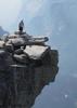
I loved Skyline Crest Trail! It winds along the spine of the ridge, each twist revealing a new, awesome view: southwest towards the Eagletail Mountains, south to the Gila Bend Mountains, southeast to South Mountain, and east into Phoenix. ⛰

Though not reaching “super bloom” levels, there were scads of flowers on Skyline Crest Trail: desert tobacco, desert globemallow, scorpionweed, desert chicory, and the only decent ocotillo I spotted all day. (Most ocotillo blooms I saw were fading to brown.)

At the top of Crest Summit Trail, I found a fairly smooth back supporting rock to recline against, and sat down for lunch and a hiking beer, while enjoying the spacious view.

I blasted through Quartz Mine Trail, 1.4 miles to the trailhead, in only 30 minutes. There may have been a few flowers on Quartz Mine Trail, but I had already got what I came for, and so wasn’t much interested in spending time looking. 😉

Hike & 💐 Video: https://vimeo.com/492802367
wildflower observationwildflower observationwildflower observationwildflower observationwildflower observation
Wildflowers Observation Moderate
_____________________
http://prestonm.com : Everyone's enjoyment of the outdoors is different and should be equally honored.
  3 archives
Jan 05 2019
avatar

 Routes 189
 Photos 7,236
 Triplogs 1,740

57 male
 Joined Apr 25 2011
 Goodyear, AZ
Verrado SOB Loop, AZ 
Verrado SOB Loop, AZ
 
Hiking avatar Jan 05 2019
NightstalkerTriplogs 1,740
Hiking5.20 Miles 633 AEG
Hiking5.20 Miles   2 Hrs   45 Mns   2.69 mph
633 ft AEG      49 Mns Break7 LBS Pack
 
1st trip
Linked   linked  
Partners partners
Gallydoll
SCA
I wanted to do a hike out in Verrado since one of my harem members lives there and is always driving super far to meet the rest of us for hikes every weekend. Saw the petroglyphs attraction there off Lost Creek trail, spotted some obvious mountain bike trails on the satellite view, and put a nice 5 mile loop together. We were rewarded with seasonally warm temps in the 40's to start our hike from the Lost Creek trailhead. While not well marked, the trails were easy to follow. Razorwire topped chainlink fence surrounds the petroglyph site, I imagine to keep the graffiti artists at bay, which is disappointing since it doesn't appear to be real effective. We picked up the SOB (South Of the Border) trail heading south right from the Petroglyph site. SOB trail was pleasant, easy to follow, sort of signed, and meandered all the way back to where we split off Lost Creek trail to the Petroglyphs. Stopped at Verrado Coffee afterward which was great way to finish the morning.
 Culture
 Culture [ checklist ]
[ checklist ]  Cairn
wildflower observationwildflower observationwildflower observationwildflower observationwildflower observation
Wildflowers Observation Light
_____________________
 
Jun 16 2017
avatar

 Routes 297
 Photos 6,928
 Triplogs 552

49 male
 Joined Dec 30 2007
 Avondale,Az
Verrado PetroglyphsPhoenix, AZ
Phoenix, AZ
Hiking avatar Jun 16 2017
StoicTriplogs 552
Hiking4.20 Miles 342 AEG
Hiking4.20 Miles   1 Hour   25 Mns   2.96 mph
342 ft AEG
 
Linked   none no linked trail guides
Partners none no partners
Took the pups on an early morning hike. We went up to the Petroglyphs then hiked a no-named trail back to the truck.
_____________________
 
Mar 13 2017
avatar

 Photos 99
 Triplogs 872

male
 Joined Mar 18 2012
 Goodyear, AZ
Lost Creek Trail - Skyline RPPhoenix, AZ
Phoenix, AZ
Hiking avatar Mar 13 2017
MikeSTriplogs 872
Hiking4.10 Miles 425 AEG
Hiking4.10 Miles      49 Mns   5.02 mph
425 ft AEG
 no routes
Linked   linked  
Partners none no partners
FBC with SOB coming back at Petrgylchs with Dave and Russ
_____________________
Subscribe to my adventure videos at: [ youtube video ]

Follow my adventures on Instagram at: adventures_az
 
Feb 28 2017
avatar

 Photos 99
 Triplogs 872

male
 Joined Mar 18 2012
 Goodyear, AZ
Verrado PetroglyphsPhoenix, AZ
Phoenix, AZ
Hiking avatar Feb 28 2017
MikeSTriplogs 872
Hiking5.60 Miles 500 AEG
Hiking5.60 Miles   1 Hour   5 Mns   5.17 mph
500 ft AEG
 no routesno photosets
Linked   none no linked trail guides
Partners none no partners
SOB for FBS with John and Trevor
_____________________
Subscribe to my adventure videos at: [ youtube video ]

Follow my adventures on Instagram at: adventures_az
 
Feb 08 2017
avatar

 Photos 99
 Triplogs 872

male
 Joined Mar 18 2012
 Goodyear, AZ
Verrado PetroglyphsPhoenix, AZ
Phoenix, AZ
Hiking avatar Feb 08 2017
MikeSTriplogs 872
Hiking5.60 Miles 590 AEG
Hiking5.60 Miles   1 Hour   2 Mns   5.42 mph
590 ft AEG
 no routesno photosets
Linked   none no linked trail guides
Partners none no partners
FBC with John, Jon, and Mike. It is amazing how much moisture is still in the ground from all the rain a few weeks ago. Should keep things green for a while.
_____________________
Subscribe to my adventure videos at: [ youtube video ]

Follow my adventures on Instagram at: adventures_az
 
Jan 31 2017
avatar

 Photos 99
 Triplogs 872

male
 Joined Mar 18 2012
 Goodyear, AZ
Verrado PetroglyphsPhoenix, AZ
Phoenix, AZ
Hiking avatar Jan 31 2017
MikeSTriplogs 872
Hiking5.70 Miles 535 AEG
Hiking5.70 Miles   1 Hour   1 Min   5.61 mph
535 ft AEG
 no routesno photosets
Linked   none no linked trail guides
Partners none no partners
FBC Reverse SOB
_____________________
Subscribe to my adventure videos at: [ youtube video ]

Follow my adventures on Instagram at: adventures_az
 
Jan 10 2017
avatar

 Photos 99
 Triplogs 872

male
 Joined Mar 18 2012
 Goodyear, AZ
Lost Creek Trail - Skyline RPPhoenix, AZ
Phoenix, AZ
Hiking avatar Jan 10 2017
MikeSTriplogs 872
Hiking4.20 Miles 425 AEG
Hiking4.20 Miles      47 Mns   5.36 mph
425 ft AEG
 no routes
Linked   linked  
Partners none no partners
Last FBC before the canyon. Ground wet and did the short loop by the petroglyphs.
_____________________
Subscribe to my adventure videos at: [ youtube video ]

Follow my adventures on Instagram at: adventures_az
  1 archive
Dec 20 2016
avatar

 Photos 99
 Triplogs 872

male
 Joined Mar 18 2012
 Goodyear, AZ
Verrado PetroglyphsPhoenix, AZ
Phoenix, AZ
Hiking avatar Dec 20 2016
MikeSTriplogs 872
Hiking5.90 Miles 595 AEG
Hiking5.90 Miles   1 Hour   13 Mns   4.85 mph
595 ft AEG
 no routesno photosets
Linked   none no linked trail guides
Partners none no partners
FBC with Petroglyphs and reverse SOB
_____________________
Subscribe to my adventure videos at: [ youtube video ]

Follow my adventures on Instagram at: adventures_az
 
Nov 27 2016
avatar

 Guides 69
 Routes 37
 Photos 3,010
 Triplogs 2,387

55 male
 Joined Oct 24 2010
 Phoenix,Az
Verrado PetroglyphsPhoenix, AZ
Phoenix, AZ
Hiking avatar Nov 27 2016
mt98dewTriplogs 2,387
Hiking7.50 Miles 285 AEG
Hiking7.50 Miles   2 Hrs   20 Mns   3.21 mph
285 ft AEG
 no routesno photosets
Linked   none no linked trail guides
Partners none no partners
Returned to hike the Verrado trail for a three-fold reason. First, I hadn't taken credit for hiking Verrado this year. Second, I wanted to finish hiking the wash that leads up to the petroglyph. Third I wanted to revisit some developing trails that were a work in progress back in 2014. Got on the trail a little after 10am. Headed CW on the Verrado but quickly abandoned it in favor of the wash. I had been hiking the wash a couple of days ago with family but abandoned it when we hit the dry falls. So I took the wash and the two dry falls up to the petroglyphs. From the petroglyph I followed the trail north and then east. As I headed east the trail split a couple of times and I stayed on the northern edge because I was anxious to see if there had been any progression with the trails that were under construction back in 2014. I'm happy to say that there is now a nice loop that heads back into the valley north of the wash. It looks like the trails are done but there is still minimal trail signage back there. I stayed on what seemed to be the outer trail though it looked as if there was an interior trail as well. I did see one sign which indicated that I was on the Highline Trail. It was in an odd spot, what I would consider to be the backside of the trail. This makes think that there are more trail signs to come. Then again, Verrado has always had poor signage, so maybe they'll continue with this tradition. Forgot my garmin today so I'll have to come back to gather proper data. Mileage is an estimate based on time spent on the trails. Trails were fairly crowded. Saw 6 bikers on the new trail additions. Wildlife included a red tail hawk, a couple of chipmunks and a garter snake.
_____________________
 
Oct 29 2016
avatar

 Photos 99
 Triplogs 872

male
 Joined Mar 18 2012
 Goodyear, AZ
Lost Creek Trail - Skyline RPPhoenix, AZ
Phoenix, AZ
Hiking avatar Oct 29 2016
MikeSTriplogs 872
Hiking5.70 Miles 550 AEG
Hiking5.70 Miles   1 Hour   21 Mns   4.22 mph
550 ft AEG
 no routes
Linked   linked  
Partners none no partners
With Russ and Mike Clark. When up Lost Creek from Verrado then explored SOB over and it dropped down into the petroglyphs.
_____________________
Subscribe to my adventure videos at: [ youtube video ]

Follow my adventures on Instagram at: adventures_az
 
Sep 05 2016
avatar

 Photos 99
 Triplogs 872

male
 Joined Mar 18 2012
 Goodyear, AZ
Verrado PetroglyphsPhoenix, AZ
Phoenix, AZ
Hiking avatar Sep 05 2016
MikeSTriplogs 872
Hiking2.90 Miles 210 AEG
Hiking2.90 Miles   1 Hour   10 Mns   2.49 mph
210 ft AEG
 no routesno photosets
Linked   none no linked trail guides
Partners none no partners
Didn't make it all the way out to the petroglyphs but from Lost Creek trail head went north then west on the loop and after hitting 1.5 miles turned around. Very slow but good to stretch my knee out. 4 weeks from trail running, can't wait.
_____________________
Subscribe to my adventure videos at: [ youtube video ]

Follow my adventures on Instagram at: adventures_az
 
May 22 2016
avatar

 Photos 99
 Triplogs 872

male
 Joined Mar 18 2012
 Goodyear, AZ
Verrado PetroglyphsPhoenix, AZ
Phoenix, AZ
Hiking avatar May 22 2016
MikeSTriplogs 872
Hiking0.70 Miles 145 AEG
Hiking0.70 Miles      25 Mns   1.68 mph
145 ft AEG
 no routesno photosets
Linked   none no linked trail guides
Partners none no partners
During BYC
_____________________
Subscribe to my adventure videos at: [ youtube video ]

Follow my adventures on Instagram at: adventures_az
 
Jan 07 2016
avatar

 Photos 99
 Triplogs 872

male
 Joined Mar 18 2012
 Goodyear, AZ
Verrado PetroglyphsPhoenix, AZ
Phoenix, AZ
Hiking avatar Jan 07 2016
MikeSTriplogs 872
Hiking4.40 Miles 495 AEG
Hiking4.40 Miles      48 Mns   5.50 mph
495 ft AEG
 no routesno photosets
Linked   none no linked trail guides
Partners none no partners
John and I were trying to re-live the epic rain run in the Verrado trail from Sept 8th 2014 but we were missing the 3 inches of rain and it was only a light rain. Fun anyways and slow in the dark.
_____________________
Subscribe to my adventure videos at: [ youtube video ]

Follow my adventures on Instagram at: adventures_az
 
May 18 2015
avatar

 Guides 69
 Routes 37
 Photos 3,010
 Triplogs 2,387

55 male
 Joined Oct 24 2010
 Phoenix,Az
Verrado PetroglyphsPhoenix, AZ
Phoenix, AZ
Run/Jog avatar May 18 2015
mt98dewTriplogs 2,387
Run/Jog4.26 Miles 285 AEG
Run/Jog4.26 Miles   1 Hour      4.26 mph
285 ft AEG
 no routesno photosets
Linked   none no linked trail guides
Partners none no partners
Easy jog on the Verrado Trail. Did this as a loop going clockwise. Trail it fairly easy to follow going this way. It s a dual track and there are signs at key points to keep you on track...to the petroglyphs. After the glyphs, the trail crosses a wash and becomes a single track, ( which is cool). But spiderwebs into a number of user trails with minimal signage. I've done this trail a few times and I swear the backside gets more confusing as more trails are created by the locals. This is not necessarily a bad thing as it adds variety, but if you are trying to stay on the "authentic" trail it is a little vexing. Had the trail to myself. Didn't see a soul the whole time. Weather was once again gorgeous!
_____________________
 
average hiking speed 2.45 mph
1, 2  Next

WARNING! Hiking and outdoor related sports can be dangerous. Be responsible and prepare for the trip. Study the area you are entering and plan accordingly. Dress for the current and unexpected weather changes. Take plenty of water. Never go alone. Make an itinerary with your plan(s), route(s), destination(s) and expected return time. Give your itinerary to trusted family and/or friends.

helpcommentissue

end of page marker