username
X
password
register
for free!
help
ArticlesGuidesRoutes
 
Photosets
 
 Comments
triplogs   photosets   labels comments more
Apache Peak - Cave Creek - 6 members in 25 triplogs have rated this an average 3.5 ( 1 to 5 best )
1, 2  Next
25 triplogs
login for filter options
Apr 13 2023
avatar

 Routes 4
 Triplogs 2

65 male
 Joined Feb 29 2016
 Scottsdale, az
Apache Peak - Cave CreekPhoenix, AZ
Phoenix, AZ
Hiking avatar Apr 13 2023
tedwilsonTriplogs 2
Hiking9.08 Miles 1,561 AEG
Hiking9.08 Miles   3 Hrs   59 Mns   2.50 mph
1,561 ft AEG      21 Mns Break
 
no photosets
1st trip
Linked   none no linked trail guides
Partners none no partners
Route Scout Route Recorded  on Route Scout | Pop | Map | Popup | MapDEX
Took this alternate route to Apache Peak as this was within walking distance from home. This involves adding legs along the perimeter of what I call Apache Valley before you reach the standard route to the summit. You can park on AZ State Trust land at 24th St and Joy Ranch. There is more parking to the north along 24th St if you wanted to cut some mileage off the trek. The hike heads north along trails and roads that generally follow Apache Wash until you intersect with the Maricopa Trail. Then westerly along the MT until you get to the standard routes to Apache Peak. Then follow trails and roads southerly along the East side of the valley back to the beginning.
wildflower observationwildflower observationwildflower observationwildflower observationwildflower observation
Wildflowers Observation None
The wildflowers are crazy this year. You have to pay special attention on the approach to the peak as some of the route is obscured by the thick wildflower growth. My legs were yellow from the knees down from pushing through.
_____________________
 
Feb 20 2023
avatar

 Routes 215
 Photos 1,337
 Triplogs 124

53 male
 Joined May 26 2017
 Phoenix, AZ
Apache Peak - Cave CreekPhoenix, AZ
Phoenix, AZ
Hiking avatar Feb 20 2023
Nate_FTriplogs 124
Hiking6.50 Miles 1,691 AEG
Hiking6.50 Miles
1,691 ft AEG
 no routes
1st trip
Linked   none no linked trail guides
Partners none no partners
Nice little hike in the New River area and not too crowded from this trailhead. Always wanted to try this peak but never got around to it. This was the perfect day for it, wildflower was starting to pop with poppies. A good rock climb near the top but had to avoid a few bee hives. Probably a one and done though.
wildflower observationwildflower observationwildflower observationwildflower observationwildflower observation
Wildflowers Observation Light
Poppies
_____________________
 
Feb 06 2022
avatar

 Guides 1
 Routes 14
 Photos 7,202
 Triplogs 5,208

68 male
 Joined Mar 16 2008
 chandler,az
Apache Pipeline Yavapai, AZ 
Apache Pipeline Yavapai, AZ
 
Hiking avatar Feb 06 2022
johnlpTriplogs 5,208
Hiking12.55 Miles 2,656 AEG
Hiking12.55 Miles   4 Hrs   57 Mns   2.63 mph
2,656 ft AEG      11 Mns Break
 no routes
1st trip
Partners partners
trekkin_gecko
Unlikely hiking combo turned out great. We started with Apache Peak via the Maricopa trail on a breezy chilly morning. We warmed up quickly making our way up through some beautiful desert full of picturesque saguaros. Apache Peak has wonderful views of the surrounding area.
Next we drove west to Lake Pleasant and the Pipeline trail. The bridge is out, so our hike from the south was a short one. We drove over to the north side and completed the trail. Along the way back we hiked up to the Yavapai Point Lookout which has really nice views of the lake and mountains.
Fun day. Thanks Kelly. :)
 Flora
 Flora [ checklist ]
[ checklist ]  African Daisy
_____________________
“Good people drink good beer.” Hunter S Thompson
 
Feb 06 2022
avatar

 Guides 10
 Routes 673
 Photos 7,281
 Triplogs 4,660

67 female
 Joined Nov 17 2008
 phoenix, az
Apache Pipeline Yavapai, AZ 
Apache Pipeline Yavapai, AZ
 
Hiking avatar Feb 06 2022
trekkin_geckoTriplogs 4,660
Hiking12.55 Miles 2,656 AEG
Hiking12.55 Miles   4 Hrs   57 Mns   2.63 mph
2,656 ft AEG      11 Mns Break
 
1st trip
john suggested apache peak for today
we had planned to do the extended hike that @bifrost and @slowandsteady did recently
set out around 0745 in 40 degree temps
the first two miles follow the maricopa trail, then we took the father's day use trail up to the peak
steeper toward the top with a little scramble up high
had some paranoia regarding the active beehive older triplogs mentioned, so when there were a few bees at the summit i wanted to head back down right away
(sorry about that, john) it's a nice summit
father's day is a good trail, but i was glad i had a hiking pole on this part
smooth sailing back to spear s trailhead
a nice peak that had been on my b list for awhile
lots of large, multi armed saguaros along the way
didn't see anyone until almost finished
we decided to head over to lake pleasant to hike pipeline canyon, which had been on john's list
parked at the south trailhead and did the shorter section first
discussed options that included wild burro, then drove to the north trailhead and did the rest of pipeline
on the return, cut over to yavapai point trail and went up to the lookout, staying on that trail on the way back
this was a nice little combo - posted our track for it
lots more to do out that way, too
fun day with a solid peak and some new trails
thanks, lp! as always, good times
 Culture
 Culture [ checklist ]
[ checklist ]  Old Glory
_____________________
hazhole
  1 archive
Jan 29 2022
avatar

 Guides 4
 Routes 491
 Photos 10,890
 Triplogs 1,257

55 male
 Joined Nov 20 2012
 Phoenix, AZ
Apache Peak - Maricopa Trail, AZ 
Apache Peak - Maricopa Trail, AZ
 
Hiking avatar Jan 29 2022
BiFrostTriplogs 1,257
Hiking10.35 Miles 2,817 AEG
Hiking10.35 Miles   5 Hrs   19 Mns   2.51 mph
2,817 ft AEG   1 Hour   12 Mns Break
 
1st trip
Partners partners
slowandsteady
From the trailhead on New River Road we headed up Apache Peak. Nice summit break and early lunch with bluebird views. After the summit we decided to explore different way down the peak and found another trail that linked Maricopa Trail. We hiked to the far end where Maricopa Trail heads east into Spur Cross rec area so good to see that connection. After that we followed Maricopa back to the trailhead.
_____________________
  1 archive
Mar 13 2021
avatar

 Guides 4
 Routes 491
 Photos 10,890
 Triplogs 1,257

55 male
 Joined Nov 20 2012
 Phoenix, AZ
Apache Peak - Cave CreekPhoenix, AZ
Phoenix, AZ
Hiking avatar Mar 13 2021
BiFrostTriplogs 1,257
Hiking6.90 Miles 2,146 AEG
Hiking6.90 Miles   2 Hrs   48 Mns   2.46 mph
2,146 ft AEG
 
1st trip
Linked   none no linked trail guides
Partners partners
John9L
First time up Apache Peak. It’s a short hike but nice summit close to town. First couple miles is somewhat flat through the saguaro’s then a steep healthy climb. Once on the summit we took a few pics and a snack but kind of windy and cold so didn’t spend much time on top. Hiked back the same way to the trailhead.
 Culture
 Culture [ checklist ]
[ checklist ]  Old Glory
_____________________
  1 archive
Mar 28 2020
avatar

 Guides 264
 Routes 2,797
 Photos 14,494
 Triplogs 5,894

55 male
 Joined Nov 20 1996
 
Apache Peak - Elephant Mtn - Maricopa Tr Loop, AZ 
Apache Peak - Elephant Mtn - Maricopa Tr Loop, AZ
 
Hiking avatar Mar 28 2020
joebartelsTriplogs 5,894
Hiking16.13 Miles 3,243 AEG
Hiking16.13 Miles   10 Hrs   19 Mns   2.00 mph
3,243 ft AEG   2 Hrs   15 Mns Break
 
1st trip
Route Scout Route Recorded  on Route Scout | Pop | Map | Popup | MapDEX
Bruce put this together in a flash. Having lightly pondered Apache Peak for many years I was in on that alone. Didn't know much about Elephant other than it didn't hold my interest. First I've been through New River. Unexpected agriculture parcels. Overall nicer than I figured. Still unsure I just looked at the boundary. Basically, I-17 to SR 51 & Carefree Hwy to Table Mesa Rd. Upper thirties to start late March seemed low as we'll be flirting with ninety degrees soon.

Apache was steeper than expected. Having learned on the hike in we had a large chunk of off-trail ahead I waited below the summit when it got uncomfortable. Most won't have an issue. Distant views are better than average.

Heading over to Elephant through more off-trail than anticipated I started having doubts. Without much reviewing I had visions of Sonoran Preserves bulldozed trails. 5 miles further North, boy I looked this hike over well... lol

This was more reminiscent of tackling Horse Mesa across to Bronco Butte. A big boy workout. Heading up wasn't encouraging either. We both failed miserably at throwing in the towel. Perfect weather, wildflowers galore and desire to get in a good full-day hike lured enough to where it would be ridiculous to turn around vs making it happen.

Lunch on Elephant Mountain 3,926 was darn nice. Cardinals Stadium to Weaver's Needle and beyond. Descending East after lunch made two things crystal clear. Cool terrain, for once I found Spur Cross vicinity intriguing. On the flip side, there will be no return since my balance requires safer footing.

8 easy miles back to square one on easy trail was mind-numbing at first. Turned out fine. Still not itching to go back. Definitely a great nearby full-day hike!

Posted from RS iOS, Android SUCKS unless you are away from cell towers or stay in airplane mode beginning to end.
 Culture
 Culture [ checklist ]
[ checklist ]  Cactuscat Pose
 Named place
 Named place [ checklist ]
[ checklist ]  Apache Peak
wildflower observationwildflower observationwildflower observationwildflower observationwildflower observation
Wildflowers Observation Substantial
owl clover was intense in areas, short and tiny in between, seriously 40% of the hike was through owl clover

NOTABLE FLORA
fiddleneck - some huge, waded through 4 ft blades of painless grass for a short segment, poppies above 3,200 ft heading up Elephant, primrose, chia, buckwheat, desert globemallow, desert marigold, narrow-leaved popcorn flower, desert chicory, saguaros galore, indian paintbrush, desert lavender, larkspur, phlox, stinknet* galore
* changed from globe chamomile since HAZ uses the USDA listings as much as possible
_____________________
- joe
 
Mar 28 2020
avatar

 Guides 41
 Routes 1,626
 Photos 14,983
 Triplogs 2,760

69 male
 Joined Jan 20 2009
 Far NE Phoenix,
Apache Peak - Elephant Mtn - Maricopa Tr Loop, AZ 
Apache Peak - Elephant Mtn - Maricopa Tr Loop, AZ
 
Hiking avatar Mar 28 2020
The_EagleTriplogs 2,760
Hiking17.15 Miles 3,507 AEG
Hiking17.15 Miles   10 Hrs   22 Mns   1.96 mph
3,507 ft AEG   1 Hour   36 Mns Break14 LBS Pack
 
1st trip
Route Scout Route Recorded  on Route Scout | Pop | Map | Popup | MapDEX
I was looking for a place that would be less traveled that we could both drive to.

I'd never hiked from the Spear S Ranch TH on 7th Street. 39 degrees and no cars in the lot at our 6:30 start. It's a nice trail to where we turned off to attack Apache Peak. There is a local "use trail" to the top, that has it's name carved into a rock. It's known as the Fathers Day Trail. Easy to follow and gets steeper and steeper to the top. The only tricky part is finding your same way down, through the break in the wall. Up top, a tattered flag and a mailbox.
[ youtube video ]

We dropped down to the saddle and then northish on another use trail. We lost it once. Off to attacking Elephant Mountain from the west. This was a slow process. Lots of up, prickly things and boulder hopping. Finally on top of the Elephant, the views are great in all directions. We had our lunch at a responsible distance.
[ youtube video ]

Exiting the peak to the east is a bit slippery and slow going. Interesting geology here.

We were happy to be back on a trail all the way back to the TH. We passed 4 hikers and 1 biker through 15 miles. the last 2 miles to the TH, we passed more.

This one zapped me. I always know is been a tougher hike when my shoulders are sore the next day.
 Flora
 Flora [ checklist ]
[ checklist ]  Dudleya
wildflower observationwildflower observationwildflower observationwildflower observationwildflower observation
Wildflowers Observation Substantial
_____________________
There is a very fine line between "hobby" and "mental illness."
Dave Barry 🦅
 
Jan 16 2020
avatar

 Guides 69
 Routes 37
 Photos 3,010
 Triplogs 2,387

55 male
 Joined Oct 24 2010
 Phoenix,Az
Apache Peak - Cave CreekPhoenix, AZ
Phoenix, AZ
Hiking avatar Jan 16 2020
mt98dewTriplogs 2,387
Hiking6.68 Miles 1,691 AEG
Hiking6.68 Miles   2 Hrs   25 Mns   2.76 mph
1,691 ft AEG
 no routesno photosets
Linked   none no linked trail guides
Partners none no partners
After work hike. Apache has been on my mind for years and I thought today would be a good day to revisit the peak. Got on the trail just before 5 and took the Maricopa Trail in until I got to the south side of Apache. From the Maricopa Trail there are two separate trails that lead up to Apache Peak. I took the first of these two trails. You have to be looking for this juncture. There is a marker there, but the trail is pretty faint. I followed the trail up to the ridge where it merged with second trail. By this time most of the mountain was in shadows and I knew the day was quickly coming to an end. I decided to push on and see how far I could get before the sun officially set. Sadly, I wasn't able to summit :( I was probably only 15 minutes from the top, but the light was already starting to fade and I did not want to be on the mountain in the dark. This can be a rough trail to negotiate in daylight, but in the dark with out a headlamp [-( . On the way down I opted for the secondary trail and was happy to note that this trail is much more defined than the one I took up. Also, noted (again), that there is another marked trail that takes off from the top of the ridgeline and heads off to the east. There are three large cairns that mark this intersection. You can't miss it. I have seen this trail a couple of times now, and have yet to follow it. I hit the Maricopa Trail in near total darkness and even though it is a well defined, and soon turned into an ATV track, it was still a little treacherous (unseen rocks and changes in trail depth). As the Maricopa Trail heads away from Apache it changes back to a single track, but with the darkness I opted to stay on the ATV track which eventually merged into a well used dirt road that brought me back to the TH. An overall exciting but unsatisfying hike with my objective unreached. Hope to get back before summer to summit and check out that side trail.
_____________________
 
Jan 26 2019
avatar

 Routes 189
 Photos 7,236
 Triplogs 1,740

57 male
 Joined Apr 25 2011
 Goodyear, AZ
Apache Peak - Cave CreekPhoenix, AZ
Phoenix, AZ
Hiking avatar Jan 26 2019
NightstalkerTriplogs 1,740
Hiking7.70 Miles 1,955 AEG
Hiking7.70 Miles   4 Hrs   57 Mns   2.10 mph
1,955 ft AEG   1 Hour   17 Mns Break13 LBS Pack
 no routes
1st trip
Linked   none no linked trail guides
Partners partners
Gallydoll
Had Jan and Gallydoll join me this morning to take a trip up Apache Peak. Followed the official route out along Maricopa Trail to Father's Day trail. Father's Day starts the long ascent up Apache Peak. Trail was easy enough to follow and turned into a scramble the last 150' or so. Fantastic views from the top. New flag flying. Mailbox pretty beat up. Gallydoll made an extended entry in the summit log that future visitors should find amusing. Took a different trail down from the saddle back to Maricopa Trail and returned to the truck.
 Culture
 Culture [ checklist ]
[ checklist ]  Gallydoll Pose
wildflower observationwildflower observationwildflower observationwildflower observationwildflower observation
Wildflowers Observation Light
_____________________
 
Apr 19 2018
avatar

 Guides 4
 Routes 52
 Photos 1,303
 Triplogs 75

female
 Joined Feb 04 2017
 Sun City
Apache Peak - Cave CreekPhoenix, AZ
Phoenix, AZ
Hiking avatar Apr 19 2018
caragrueyTriplogs 75
Hiking6.50 Miles 1,691 AEG
Hiking6.50 Miles
1,691 ft AEG
 
1st trip
Linked   none no linked trail guides
Partners none no partners
Trail seems to have improved some, but still faint where you left turn up to summit trail. There is a new flagpole at the summit, but unfortunately the mailbox is in need of repair. Great day!
_____________________
 
Mar 27 2017
avatar

 Guides 2
 Photos 8
 Triplogs 16

35 male
 Joined Nov 15 2016
 Glendale, Arizon
Apache Peak - Cave CreekPhoenix, AZ
Phoenix, AZ
Hiking avatar Mar 27 2017
hoopshikerTriplogs 16
Hiking6.50 Miles 1,691 AEG
Hiking6.50 Miles   2 Hrs   50 Mns   2.52 mph
1,691 ft AEG      15 Mns Break
 no routesno photosets
1st trip
Linked   none no linked trail guides
Partners none no partners
Got a little lost originally looking for the faint trail. After you come into the first part of the saddle keep going right. So you'll start from the New River Rd trailhead and head east then south, then east again at the abrupt turn. The sign is on the left about 100 feet or more after the turn left. From here when I did find my way the overgrowth from the spring made this already hard trail to follow extremely difficult. I got off once but a good note is to try and not get too far away from where the runoff dry bed is between the big mountain and the little mountain. Unfortunately I could not make it all the way to the summit, overgrowth from the beautiful wildflower made this tough, not only did they get in the way but were covered with bees and I didn't want to disturb them in the height of bee season. Overall not really a tough hike but challenging because the trail really isn't that developed.
_____________________
 
Jan 25 2017
avatar

 Routes 36
 Photos 2,658
 Triplogs 1,347

67 male
 Joined Jul 28 2004
 Scottsdale, AZ
Apache Peak - Cave CreekPhoenix, AZ
Phoenix, AZ
Hiking avatar Jan 25 2017
mazatzalTriplogs 1,347
Hiking4.00 Miles 1,691 AEG
Hiking4.00 Miles   2 Hrs   40 Mns   1.55 mph
1,691 ft AEG      5 Mns Break
 no routesno photosets
1st trip
Linked   none no linked trail guides
Partners none no partners
Went up from the northeast side - looked less steep on Topo :-k Still pretty steep with loose rock :sweat:
_____________________
 
Jan 22 2017
avatar

 Guides 1
 Routes 226
 Photos 1,675
 Triplogs 1,867

65 male
 Joined Oct 17 2008
 Phoenix, AZ
Apache Peak Loop, AZ 
Apache Peak Loop, AZ
 
Hiking avatar Jan 22 2017
rcorfmanTriplogs 1,867
Hiking7.17 Miles 2,274 AEG
Hiking7.17 Miles   4 Hrs   24 Mns   1.77 mph
2,274 ft AEG      21 Mns Break10 LBS Pack
 
1st trip
Partners none no partners
The day's plan was to hike a loop starting at 24th St. and Calvary, hiking trails I'm familiar with to get me up Apache Peak, then over the south side to the Maricopa Trail and up peak 2875 to the SW, then back to the start.

From parking, I headed east through the gate and shortly got on a trail. I don't know if it's named, though I've heard it called the chocolate trail. Anyhow, the trail heads mostly east and a bit south and ends at the well of off Roger Creek. I've heard it called Odell Well, but again, I have no idea if that's correct or not. There's a large cement tank with surrounding trough that is no longer functional. Since I was last here, the ranch has installed metal tanks and troughs for the livestock. It was muddy and I almost slipped on my pumpkin but saved myself and only suffered a muddy hand.

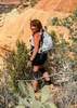
From the well, I cut cross country to the trail that goes south between Momma and Poppa Apache. There were fresh deer and coyote tracks along the trail soft and wet from the rain. The trail was easier to follow than I expected and brush was not a problem. Shortly I reached the junction for the peak trail. It gets steep and is a bit of a scramble. I had some concern about rocks breaking loose due to the wet and soft dirt after all the rain we've been getting so I paid closer attention to how I moved up the trail.

Once on top, I surveyed the surroundings, deciding how I might finish my loop once I left the Maricopa Trail. I also noticed the US flag is gone. The staff is still there but the flag has flown the coop. I stopped to find a geocache hidden early last December and then headed off the peak. I lost the trail for a bit on the way down. I thought I was north of it so I headed south for a bit but that just took me away from the trail; I needed to head back north. Finally I was back on track and made it to the CCRT (Cave Creek Recreational Trail) which I followed SE for a ways before it dropped down to the Maricopa Trail.

After a ways, I left the MT to climb peak 2875 for a geocache. Interestingly, shortly after leaving the MT, I came across another trail. It had some cairns but I don't think it is used much if at all anymore. I followed it for a bit before following a wash up. Eventually I left the wash to follow a ridge and when I did, I saw the head and rack of what was a very nice buck. He took off a second after I spotted him. I was hoping to spy him again when I got on the ridge but no such luck. From there I found another trail that I followed up the ridge. It connected with an old road (maybe it was the road?) that I followed to an abandoned mine. After the mine, I cut up the slope to reach the peak and ran into some more trails.

Once on top, I found a memorial for a boy named Sage Gustafson. I seem to run across memorials frequently and they are always sad for me. I also found another geocache, aptly named Sage, then continued north along the ridge to another geocache. Once I found that, I dropped off the hill back down to the Maricopa Trail. I followed the MT to a dirt road, where I turned right (the MT has actually been rerouted to a trailhead along New River Rd).

I was hoping to follow the roads across and back to Cavalry Rd, but there was a large sign saying the area was private Greer Ranch land, so I hung a right up an old road and cut across a hill and into a wash. I worked my way up the wash and across Apache Peak's slope until I was able to take 24th St. back to my truck.
_____________________
Go find a LonelyCache
 
Dec 17 2016
avatar

 Routes 1
 Photos 15
 Triplogs 17

45 male
 Joined Mar 04 2016
 Peoria, AZ
Apache Peak - Cave CreekPhoenix, AZ
Phoenix, AZ
Hiking avatar Dec 17 2016
climbrock5Triplogs 17
Hiking6.50 Miles 1,691 AEG
Hiking6.50 Miles   3 Hrs   35 Mns   2.00 mph
1,691 ft AEG      20 Mns Break
 no routesno photosets
1st trip
Linked   none no linked trail guides
Partners none no partners
Never really spend anytime near cave creek. Decided to go and climb Apache Peak. We parked at the trail head. Several people improving the trails for mountain biking along the portion that is the Maricopa trail.

Glad I downloaded someones route to my GPS. Even with it still got off the trail once or twice when heading to the top of the peak. Several people commented on the great views. I wasn't really all that impressed. Good work out. As we got close to the top we kept running into large piles of poo. Didn't look like cow patties. Are these from sheep? We heard there where some in the area, but didn't see any.

On a side note, there is definitely an active beehive near the top. Be warned.

Fun hike. The trail is much easier to follow on the way down. Made it back fairly quickly.
_____________________
 
Jan 22 2016
avatar

 Guides 27
 Routes 61
 Photos 2,620
 Triplogs 700

69 male
 Joined Jan 23 2008
 Phoenix, AZ
Apache Peak - Cave CreekPhoenix, AZ
Phoenix, AZ
Hiking avatar Jan 22 2016
AZWanderingBearTriplogs 700
Hiking6.50 Miles 1,691 AEG
Hiking6.50 Miles   3 Hrs   3 Mns   2.41 mph
1,691 ft AEG      21 Mns Break
 
Partners none no partners
Nice afternoon, so thought why not a short but tough little summit. The climb/descent part of this is mostly loose rock and pretty steep, but I only fell once with no damage. Had to navigate around a beehive in some rocks very near the top. Views were outstanding.
 Named place
 Named place [ checklist ]
[ checklist ]  Apache Peak
wildflower observationwildflower observationwildflower observationwildflower observationwildflower observation
Wildflowers Observation Isolated
A little Globe Mallow and some others
_____________________
All you have is your fire...
And the place you need to reach
  4 archives
Jan 18 2016
avatar

 Routes 173
 Photos 1,613
 Triplogs 285

50 male
 Joined Nov 11 2014
 Manchester, NH
Apache Peak - Cave CreekPhoenix, AZ
Phoenix, AZ
Hiking avatar Jan 18 2016
JasonCleghornTriplogs 285
Hiking6.92 Miles 1,464 AEG
Hiking6.92 Miles   2 Hrs   47 Mns   2.75 mph
1,464 ft AEG      16 Mns Break
 
no photosets
Partners none no partners
It's kind of embarrassing, but I pretty much turned back on this peak a few months ago. I got unnerved and worried about getting down. Not TODAY!!!

This is a good hike and climb for someone trying to get use to some scrambling at the top of a peak. The trail basically ends about 200-300 feet from the summit and the rest is a mixture of light and hand over hand scrambling.

There's an American flag and mailbox at the summit. Only saw a screeching hawk, no javelinas, no mountain lion. Signed the summit log and got down. I find if I audibly talk myself down the steep scrambling descents it helps, LOL... :D
_____________________
Follow me on Instagram: hikingjason
"It's not the mountains that we conquer, but ourselves"
 
Aug 14 2015
avatar

 Routes 173
 Photos 1,613
 Triplogs 285

50 male
 Joined Nov 11 2014
 Manchester, NH
Apache Peak - Cave CreekPhoenix, AZ
Phoenix, AZ
Hiking avatar Aug 14 2015
JasonCleghornTriplogs 285
Hiking7.20 Miles 1,392 AEG
Hiking7.20 Miles   2 Hrs   49 Mns   2.81 mph
1,392 ft AEG      15 Mns Break15 LBS Pack
 
no photosets
Linked   none no linked trail guides
Partners none no partners
I'll call it a near success. Got to within 300 feet of the summit but became afraid of getting down on the scree, considering I was sliding 2 feet back for every one foot I was taking. I saw my first four javelina. Proof you can hike at 100-105 provided you drink and eat properly...
_____________________
Follow me on Instagram: hikingjason
"It's not the mountains that we conquer, but ourselves"
 
Jul 21 2015
avatar

 Guides 2
 Routes 251
 Photos 4,593
 Triplogs 3,212

63 male
 Joined Feb 26 2008
 Scottsdale, AZ
Apache Peak - Cave CreekPhoenix, AZ
Phoenix, AZ
Hiking avatar Jul 21 2015
BobPTriplogs 3,212
Hiking4.05 Miles 1,470 AEG
Hiking4.05 Miles
1,470 ft AEG
 no routes
1st trip
Linked   none no linked trail guides
Partners none no partners
I rarely use the word epic and when I do its only in context of something negative. This hike almost became epic and was slightly epic. A 4 out of 10 on the epic scale but it could've been a full blow 10 epic if I was really unlucky.

It all started at the crack of 8am as I followed a well maintained trail for about 1.25 miles. Off-trail wasn't too bad until all hell broke loose. Never heard them and when I saw them it was too late. Down climbing was painfull and :scared: 
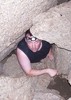
and it only got worse. Reinforcements were called in twice as I retreated to the cholla field and safety. As I was down climbing I was stung several times on my head and when I started to retreat I pulled my shirt over my head and started throwing haymakers. They regrouped and kept coming I kept going lower and finally it stopped. After all the chaos, I perfect calm came to me and I breathed. As a child, I fell into a yellow jackets nest and was stung over 300 times. It landed me in the emergency room which happend to me time to time. Getting stung a dozen or so times was no big deal. I'm not gonna let this ruin my hike so I traversed around and headed back to the top. It hurt when I ran my fingers thru my hair so I stopped doing that.

Stingers in your head by the honeybees. Kinda like prickers in your face by the bushwackers.

And now for a little bee humor https://youtu.be/Dp ... t=48

Not sure if they were these...but they sure acted like them.

From the internet:
The sting of the Africanized Honey Bee is no more potent than your garden variety honey bee and they look pretty much the same. What makes AHBs more dangerous is that they are more easily provoked, quick to swarm, attack in greater numbers, and pursue their victims for greater distances. The AHB colony can remain agitated longer and may attack up to a quarter of a mile away from the hive. In Arizona, the AHB colonies have grown and the more aggressive colonies are the ones that have survived the droughts of the past few years. The summer is the peak period for bee attacks because there is less honey, and the bees become more protective of their hives.


Long triplog. My original planned triplog was going to be two words. Sorry LAZ.
 Culture
 Culture [ checklist ]
[ checklist ]  Memorial
 Named place
 Named place [ checklist ]
[ checklist ]  Apache Peak
_____________________
https://www.seeitourway.org
Always pronounce Egeszsegedre properly......
If you like this triplog you must be a friend of BrunoP
  1 archive
Feb 16 2015
avatar

 Routes 297
 Photos 6,928
 Triplogs 552

49 male
 Joined Dec 30 2007
 Avondale,Az
Apache Peak - Cave CreekPhoenix, AZ
Phoenix, AZ
Hiking avatar Feb 16 2015
StoicTriplogs 552
Hiking6.16 Miles 1,532 AEG
Hiking6.16 Miles   3 Hrs   45 Mns   2.05 mph
1,532 ft AEG      45 Mns Break
 
1st trip
Linked   none no linked trail guides
Partners none no partners
The pups and I hiked Apache Peak following a close path to Darth Stiller's GPS track. I did start in a different location not to far off from his. The spot where I started does needs a high clearance vehicle to get to. Everything was going great until the last 1/8 of a mile. It was rough. I had to help my bigger dog in a three spots. My Jack Russell scaled the mountain with out any problems. Overall a great hike, with perfect weather. To bad the mailbox at the top has bullet holes in it. The signed registries gets ruined everytime it rains. Some dated back to 06-07

I wouldn't recommend taking dogs to the top. There is a lot of cactus and boulder climbing.
 Fauna
 Fauna [ checklist ]
[ checklist ]  Dog
 Named place
 Named place [ checklist ]
[ checklist ]  Apache Peak
_____________________
  2 archives
average hiking speed 2.32 mph
1, 2  Next

WARNING! Hiking and outdoor related sports can be dangerous. Be responsible and prepare for the trip. Study the area you are entering and plan accordingly. Dress for the current and unexpected weather changes. Take plenty of water. Never go alone. Make an itinerary with your plan(s), route(s), destination(s) and expected return time. Give your itinerary to trusted family and/or friends.

helpcommentissue

end of page marker