|
| | | Pat Scott Peak and Ramsey Peak, AZ | | | |
|
|
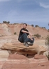
Pat Scott Peak and Ramsey Peak, AZ
| | |
| |
|
| Hiking | 10.67 Miles |
4,016 AEG |
| | Hiking | 10.67 Miles | 6 Hrs 49 Mns | | 1.68 mph |
| 4,016 ft AEG | 29 Mns Break | | | |
|
|
| |
| Partners |
|
none
[ show ]
| no partners | | I haven’t done many peaks in the Huachucas and I’ve been patiently waiting for the weather to cooperate before knocking off some more of the ‘big gun’ peaks in this range. With overcast skies and wind [but not rain] in the forest, I put my trust in my cell phone’s weather app as I headed for higher ground. As long as there were no surprise storms/showers, the nippy conditions were absolutely perfect as far as I was concerned… provided I don’t get dangerously cold, I’d take being miserably cold any day over better weather + buzzing bees. Miraculously, despite some very strong wind gusts in a handful of places, [including one atop Ramsey Peak that literally almost sent me to my pumpkin], I was perfectly comfortable on the 8,700’+ peak, [without even breaking out all of my layers]. To top it off, I didn’t see or hear a single bee. 
As far as my adventure was concerned, it was definitely a ‘game-day decision’ type of deal in more ways than one. Since I’d routed up a bunch of options in terms of the peaks on my lists as well as potential starting points, I really didn’t decide on what I was doing until I got to Sierra Vista. Eager to hit the trails after personal biz once again resulted in another late start, [although luckily not quite as late as the previous day’s 3 PM launch…], I started with what would have been one of the closer options: the Fort Huachuca side of the range. I’ve seen a few routes where other HAZ’ers have launched from areas inside of the Reservation Boundary, but I wasn’t quite sure how the whole thing worked. The guards at the entrance were very helpful and explained that after filling out some paperwork and clearing a background check [which they said takes only a few minutes], I’d be free to launch from any TH within the boundary. Problem was, I had my gun with me, which is not allowed inside; and given how late of a start I’d gotten, I didn’t want to take the time to find a gun shop that would hold it. Thus, I continued along Highway 90.
Chumley recently posted a very fun-looking route [ triplog ] that incorporates both Pat Scott & Ramsey Peaks, and I had saved his route in the event I decided on those peaks, [which definitely looked to be the next best/closest option]. Thus, I decided to head for the launch point, which was up Carr Canyon Road. However, [recalling from the topo that the Ramsey Canyon Trail looked to be another viable starting point], I couldn’t resist turning up Ramsey Canyon Road since that was even closer than Carr Canyon Road. In terms of public access, Ramsey Canyon Road ends at The Nature Conservancy, and for only a *$3 fee [*as a resident of Santa Cruz County], it would have made for a perfect start point… minus the fact that the parking lot is gated shut at 4 PM and it was already almost 11 AM…
Rather than backtrack to Carr Canyon Road and risk cutter things even closer in terms of the time that would be left to complete this kind of a hike, I phoned a Bed & Breakfast type place in the area and asked if I could pay them to park in their lot so I could get my hike in. They were super cool and agreed. Thus, I kicked things off up the Ramsey Canyon Trail. I won’t go into tons of detail since this trail is covered in full here, [ Ramsey Canyon Trail ] , but a couple of thoughts:
1. The Nature Conservancy has done one hell of an awesome job in preserving this area; and the way they’ve built the trail around the ‘exhibits’ [without making it look or feel trashy/touristy] is really superb. As far as I’m concerned, the $3 / $6 fee is well worth it just to see the beginning part of the trail with the exhibits.
2. The waterfalls & pools in Ramsey Canyon are sensational… in fact, I thought they were more beautiful than those in Ash Creek in the Galiuros.
After heading up the Ramsey Canyon Trail for a little under 3 miles, I intersected with Chumley’s tracks at the junction of the Ramsey Canyon Trail & Pat Scott Canyon Trail, [at which point, I planned to follow his route up the Pat Scott Canyon Trail and onto the Crest Trail; then take a very short side trip up to Pat Scott Peak; and finally continue on to Ramsey Peak]. However, shortly after heading up the Pat Scott Canyon Trail, I encountered some very annoying deadfall, [go figure, my attempt to stay as close to the trail as possible while circumventing the deadfall resulted in a black & blue shin… yet my epic bushwhack return, [including a Class 4 climb down a near vertical rock slab], did not even result in a slight scratch.
Shortly after the deadfall was the section of trail with the switchbacks, and toward the top of that, I ended up off-trail thanks to some snow that concealed the correct route. At that point, I consulted Route Scout and saw that I was very close to the summit of Pat Scott Peak; in fact, the grassy terrain leading toward the peak looked a lot more favorably that the snowy slope I’d have to head for if I wanted to get back onto the trail. Thus, I headed for the peak. Chumley’s description sums it up nicely… and, in addition to lack of prominence, I also found the views to be lacking, thanks to being blocked by trees in most directions. The unnamed prominent points en route to Ramsey Peak had much better views. Nonetheless, it was still fun to flip through the register atop Pat Scott Peak; which, as Chumley mentioned, doesn’t have much space left to sign; [and people were signing all out of order]. On the rare occasions when this kind of thing happens, [i.e. no blank pages AND people signing out of order], I like to sign the first page and did not hesitate to do so here. I’ll have to start carrying a small notebook [and writing implement] again.
Shortly after Pat Scott Peak, the wind really picked up [or maybe I just stepped into the line of fire since it seemed to be quite windy the whole day]. I tend to fare worse than average when it comes to handling cold temps; so it was a pleasant surprise to feel comfortable/toasty at 8,500’+ on a windy Winter day, [although I did need to put on my hat, gloves, and 2nd fleece jacket]. Luckily the routes along the ridge leading to Ramsey Peak often ran just North of the top of the ridge, which meant almost complete protection from the wind. Due to some brush in the area of the highpoint, [along with several boulders that appeared to be about the same height], the highest physical point was not entirely clear; however, the register was actually sitting out on top of a small summit cairn/rock pile. It looked to be in a secure position [shielded from larger rocks on other sides], so after signing, I left it how I found it and did not attempt to cover it. There is a main looking notebook with more recent sign-ins as well as several loose sheets of paper, which appear to be older sign-ins for the most part. Also inside of the main glass register is a very small container that looked like a pill bottle. The pages within that container were jammed in pretty good, [and I did not want to damage them by attempting to take them all out], but I was able to get the first one out with ease and it goes back to 1989. The views atop Ramsey Peak were just awesome; and it was extremely nice to find several spots that were shielded from the wind by the surrounding brush / other boulders where I could enjoy the views.
As for my epic bushwhack return… it was really a spur of the moment decision; and I can’t help but smile at just how awesome it turned out. Initially, I fully intended to take the trail back; but after reaching the summit, the thought of: retracing my steps over the super windy sections of ridge, then trying to follow the trail through the snowy section, AND finally circumventing the section with the downed trees had really lost its appeal… thus, I opted for a ‘blind’ bushwhack descent, heading NE off Ramsey Peak. Not only had I not even drawn out a route to follow, I hadn’t even been paying very good attention on my approach to determine if such a return was something I even wanted to attempt. All I remember from looking at the terrain in the beginning was tons of craggy / cliffy areas… yet after my Galiuro trip, I figured I’d be good to go as long as the topo contours weren’t touching. 
Aside from one Class 4, [which very likely could’ve been circumvented altogether had I had the patience to investigate the terrain beyond 10-20 feet on either side of me], everything else was smooth sailing and a total blast. There were a few very fun Class 3’s, but surprisingly little climbing/scrambling, relative to how cliffy/craggy the surrounding terrain was. Given that bouldering is my forte, even the Class 4 climb proved to be fun… although thanks to forgetting to remove my gun from the side pocket before chucking my pack down the mini-cliff in front of me, my heart was definitely skipping beats as I negotiated the climb; and it was a frightful 1-2 minutes when I recovered my pack, only to find that the gun was not with it. VERY luckily, I somehow managed to find my gun [and relatively quickly, given that it ended up about 20-30 feet further downhill from where my pack had landed]. I’ll never make that mistake again!
Despite some very steep slopes, there was little brush, almost no thorny vegetation, and soft, good-gripping dirt footing, all of which made for a very pleasant descent. To top things off, the routes blazed by the deer, bear, and our International friends definitely made things even easier. The Brown Canyon Trail #115 is not shown on CalTopo; and, [not having know the trail was there], I decided to contour out of the shallow gulley I’d been in for most of my descent and up onto the ridge to the East of it in order to start scanning the terrain for an ideal spot to drop back down into Ramsey Canyon & rejoin the Ramsey Canyon Trail. Unlike my previous two trips to the Huachucas, I’m REALLY glad Route Scout topo was cooperating on this one; having the topo contours was very helpful to say the least. Very shortly before reconnecting with the Ramsey Canyon Trail, I suddenly came out on the Brown Canyon Trail #115, which was definitely a surprise since the topo does not show this trail. Once on the trail, the rest of the way back was smooth sailing; and I even made it back in time to check out some of the neat ‘exhibits’ along the beginning of the Ramsey Canyon Trail. All in all, it was a fantastic adventure to say the least. |
| _____________________
| God save the Prom Queen, cuz [reality check!] AEG's King...! |
| | |
|
|
|
 Route Editor


 a bit at the Brown Canyon Ranch House, and added a few archive pictures of the pond & an additional regional water source nearby. I then moved toward the San Pedro River on Ramsey Canyon Rd. until Moson Rd. etc. finally completing a Loop back to my Barrio in Sierra Vista, AZ. Had I known there were no photos of Brown Canyon Spring I would have got them for sure, as my phone was packed away and not on my belt - next time!