username
X
password
register
for free!
help
ArticlesGuidesRoutes
 
Photosets
 
 Comments
triplogs   photosets   labels comments more
Mitten Ridge - Bear Paw Loop - 4 members in 14 triplogs have rated this an average 4.8 ( 1 to 5 best )
14 triplogs
login for filter options
Mar 11 2024
avatar

 Photos 268
 Triplogs 17

female
 Joined Mar 12 2021
 Seattle, WA
Mitten Ridge - Bear Paw LoopSedona, AZ
Sedona, AZ
Hiking avatar Mar 11 2024
rubywranglerTriplogs 17
Hiking
Hiking
 no routes
1st trip
Linked   none no linked trail guides
Partners none no partners
Gorgeous day and a fun detour en route from Tucson to Flag. I thought I was being clever by pushing my trip (and hike) back a day to avoid the weekend, but I was foiled by spring break :o Road traffic was horrendous but the trail traffic wasn't bad. No problem getting a parking space mid-day. The painted-on trail markers are getting a little faint and obscured by natural white markings on the Cowpies side. Hangover is my favorite trail in Sedona but I forgot how steep the rock is in places! Folks who ride it must be insane.
 
Nov 05 2023
avatar

 Guides 2
 Routes 207
 Photos 93
 Triplogs 204

male
 Joined Aug 08 2020
 Phx az
Mitten Ridge - Bear Paw LoopSedona, AZ
Sedona, AZ
Hiking avatar Nov 05 2023
ScaredyCatTriplogs 204
Hiking9.42 Miles 1,195 AEG
Hiking9.42 Miles   4 Hrs   53 Mns   2.29 mph
1,195 ft AEG      46 Mns Break
 
no photosets
1st trip
Partners none no partners
Route Scout Route Recorded  on Route Scout | Pop | Map | Popup | MapDEX
Rounded up 3 hikers from Meetup. Parking full so parked across the street on the other side of the gate. This is the trail on the right side of the TH.

Munds Wagon Trail runs adjacent to Schnebly Hill Rd. Hangover trail is the most adventurous section and took the longest. Pay attention to RF. Cow Pies is short and connects to the Jeep rd.

Will have to return to drive Schnebly and do a different variation of this outing.
 
May 24 2023
avatar

 Guides 21
 Routes 1,182
 Photos 36,858
 Triplogs 1,570

69 female
 Joined Feb 26 2004
 Phoenix, AZ
Hangover Loop, AZ 
Hangover Loop, AZ
 
Hiking avatar May 24 2023
tibberTriplogs 1,570
Hiking9.41 Miles 1,464 AEG
Hiking9.41 Miles   5 Hrs   54 Mns   1.93 mph
1,464 ft AEG   1 Hour   1 Min Break
 
1st trip
Partners partners
trekkin_gecko
Route Scout Route Recorded  on Route Scout | Pop | Map | Popup | MapDEX
Kelly is helping me do some prep hikes for my big outing this summer.  We hadn't done this for 7 years and decided it would be a good one to do again.  We made the drive north and just like several years ago, we blew by the turn ](*,) for Sedona but realized it right away, unlike the last time when it was several miles before we realized it.  We finally made it to the TH and geared up.  It was a little warmer than I would have liked but we did get a breeze that picked up later in the day.

We headed out on Munds Wagon Trail and I was surprised that we saw as many people as we did until after we took the first junction for the Hangover Trail.  There were some nice wildflowers along the way including what I thought was Hollyhock but I now believe was Palmer's Penstemon.  The Penstemons were almost a grove in a couple places.  We were quite surprised to see some water in the drainages... and running water at that.  You cross the drainage many times during this hike before and after you come down from the Hangover.  We enjoyed checking out the water :)
 
Kelly suggested we do the loop clockwise as we had not done it this way.  I was a tad reluctant as we didn't know the elevation gain but we went for it.  This turned out to be the perfect choice; especially after coming down that relentless hill from Schnebly Road later.  The Hangover Trail in this area was in nice shape and you had good views along the way too.  We did run into a bicycle rider here.  It was interesting to see how the trail wrapped around the base of the mountain and takes you up fairly easily to the western saddle.  I had downloaded DixieFlyer's route just in case we wanted to take a shot at the arches/windows above us to the west. I told Kelly to go ahead and I'd wait but she suggested I come along so I mumbled something and followed her.

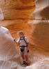
Well after several stabs at different routes to get up a steep layer of bedrock, we ended up turning back.  We did spot a bike rider across the way that pondered going straight down the opposite mountainside to the saddle.  I can't even imagine.  We never did see him complete the task.  Kelly figured we could probably get up this one section with good effort but getting back down might be a little dicey. I did get a few good pictures of her attempt.  In fact, getting back down to the saddle was slippery and we had to do a little rumpaging. 

Once back at the saddle on flat bedrock we headed straight up a couple more levels to the designated trail (on bedrock) and enjoyed our hike to the north side as the views kept us in awe.  Oh ya, this next part... now I remember, it is incredibly vertical and a tad tricky in spots to get up once you have to veer away from something of a trail.  Thank goodness for the white marks that helped guide us up and back south.  I had my heavy day pack on so this was a tad challenging : rambo : .

We finally made it to the last level at the base of the top tier.  And now it was time to head east, hugging the side of the mountain.  The trail is dicey in sections too but nothing too bad.  It is amazing how they fit this trail in here.  The overhang sections are so impressive and today there were water seeps, moss and some plants growing right out of the walls. And oddly enough, I got hit by a rock coming off the hangover above me. I didn't see Kelly again until I got to the area where you cross below the saddle.  I did quite a bit of filming on my way and would occasionally stop to inhale the views.  I finally got to where I could see Kelly on the east side below the saddle. We had one quick steep section before we arrived at the top of the saddle.  For some reason, my mouth got really dry while hiking between the saddles; such an odd thing.

We found a nice restaurant, I mean some comfortable rocks :D , to sit on for lunch time.  We were only half-way done with the hike but at least it was downhill from here.  We headed west across the saddle and then down a layer heading east.  However, as Kelly was running point pretty far ahead she came back to say this wasn't the way.  So now we were on the hunt for the white marks which were pretty much on this west side as the trail headed down the layers to get to a bigger layer where all the big loose rocks were hanging out.  We pretty much stayed on this layer still enjoying the scenery and a lizard that looked turquoise in this light.  I dropped my phone for the second time today, UGH! There were a couple sharp ups and downs as we finally reached the Cow Pies Trail.  While the Cow Pies Trail is short, it packs a nice 360 view. 
 
It was a little tricky finding the white marks to follow the trail across this huge area of bedrock, before making it into the trees and to the road.  We noticed how intensely green the trees seemed on the tall hillsides to our east; I think because they had just leafed out in some cases. We crossed the road and did a zig when we should have zagged to get on the Munds Wagon Trail for the last couple miles back to the trailhead.  The sun was warm so I was glad for the breeze and the occasional shade created by the pine trees as we made our way back to the creek.  The trail seems to be on a constant down so I was glad Kelly had made the choice to try it clockwise.  I had forgotten how relentless the trail would have been on the way up.

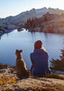
We made it to the creek where once again we found running water and some deep pools.  I asked Kelly for one more break before finishing off the last few miles.  We found a great setting including a nice big rock to sit on with a pool in front of us and the red rocks beyond.  Just past the junction with Hangover west, we were more in the grassy area and some more flora.  We still crossed the creek drainage and the road a few times before that last little hill where we found a beautiful smattering of blooming prickly pear cactus.  It was starting to get a bit warmer now so I was glad when we could see the trailhead in the not too far distance.

We enjoyed our beers and peanuts before heading south, but not before asking google for a place for lunch.  We lucked out and ate at the replacement of the Blue Moon.  We had great food and I had a stellar margarita.  The chairs are also very comfortable here at Colt Grill BBQ and Spirits.

I took quite a few movies and if you've done this Loop, you know why.  It's really a great hike.  Once again, I haven't finished reviewing the videos.
Part 1 Munds Wagon Trail and onto the Hangover Trail [ youtube video ]
Part 2 Hangover Trail from before the western saddle and up to the Hangover Trail  [ youtube video ]
Part 3 Hangover Trail from the hanging part to the eastern saddle [ youtube video ]
Part 4 Hangover Trail from below the eastern saddle, Cowpies and Munds Wagon trails  [ youtube video ]

WATCH 9:01AM-2:54PM 8.72 miles, 4547-5374 elevation. 133 avg bpm/163 max. 37% Zone 5 max, 47% Zone 4 anaerobic, 14% Zone 3 aerobic burning 2400 calories. Starting temp 65.8 sunny and 36% humidity.
wildflower observationwildflower observationwildflower observationwildflower observationwildflower observation
Wildflowers Observation Moderate
_____________________
For me, sometimes it's just as much about the journey as the destination.
Oh, and once in awhile, don't forget to look back at the trail you've traveled.
 
May 21 2022
avatar

 Guides 41
 Routes 1,626
 Photos 14,983
 Triplogs 2,760

69 male
 Joined Jan 20 2009
 Far NE Phoenix,
Casner Damifino Hangover Schnebly Hill Loop, AZ 
Casner Damifino Hangover Schnebly Hill Loop, AZ
 
Hiking avatar May 21 2022
The_EagleTriplogs 2,760
Hiking15.06 Miles 3,168 AEG
Hiking15.06 Miles   7 Hrs   59 Mns   2.22 mph
3,168 ft AEG   1 Hour   12 Mns Break14 LBS Pack
 
1st trip
Route Scout Route Recorded  on Route Scout | Pop | Map | Popup | MapDEX
It's been awhile since we've hiken in Sedona. The forecast was showing favorable temps, so I worked up a loop with some of my favorites. I'm also not a fan of fighting the afternoon traffice in Sedona, so we came in via Schnebly Hill Rd, off I-17. This is 6 miles of dirt to get to the Schnebly Hill Vista TH. Any vehicle can make it to this point. After that, HC with good tires are an absolute must. The parking lot is worse than any portion of the road to this point.

We started on Casner Canyon Trail #11 heading down. The views open up to the Sedona city area as you drop. Towards Oak Creek, you start seeing some interesting geology. The Oak Creek area is very picturesque.

On the Damifino Trail, it appears that they may have decommissioned the lower portion ending at Mitten Ridge. Where it meets Casner Canyon, it is no longer obvious. Once you get in a bit it becomes very obvious and is easy to follow all the way to the smooth red rock section. The important part here is to get high enough to hit the trail on the proper contour to get to Mitten Ridge.

The Hangover Trail is my favorite trail in Sedona. It never disappoints. I still thinks MTB'ers who do this trail have multiple screws loose.

On the Munds Wagon Trail we start the long climb, past the Cow Pies TH, past the Merry Go Round and up Schnebly Hill Trail #158. We climbed up to the saddle just before the steep ascent to Munds Mountain. We took a late lunch and then hit the FR's back to the TH.

A great day in Sedona
_____________________
There is a very fine line between "hobby" and "mental illness."
Dave Barry 🦅
 
May 21 2022
avatar

 Guides 264
 Routes 2,797
 Photos 14,494
 Triplogs 5,894

55 male
 Joined Nov 20 1996
 
Casner Damifino Hangover Schnebly Hill Loop, AZ 
Casner Damifino Hangover Schnebly Hill Loop, AZ
 
Hiking avatar May 21 2022
joebartelsTriplogs 5,894
Hiking14.46 Miles 3,011 AEG
Hiking14.46 Miles   7 Hrs   59 Mns   2.17 mph
3,011 ft AEG   1 Hour   19 Mns Break
 
1st trip
Route Scout Route Recorded  on Route Scout | Pop | Map | Popup | MapDEX
From Schnebly Hill Vista we headed out on Casner Canyon Trail #11 at 55°. This is among the most under-hiked trail with stunning views. 1,500 ft elevation drop does not lure out-n-back hikers and looping options are not easy.

Reaching Oak Creek, the majesty of this loop hits another high note. Damifino Trail heads up before the creek. It is blocked off because it is not an official trail. Damfino Canyon (minus the first i) is further south of Mitten Ridge.

Heading up starts rough. Then it is a nice stroll above Grasshopper Point. Two daisy-chained red rock ascents a bit later pushed my limits of balance. Then it's on to the prize Hangover Trail. Despite whining about overcrowding since I started HAZ, we encounter just one guy on the north, a couple rounding the mitten, and a few more down into Bear Wallow Canyon.

We merged into Munds Wagon Trail #78 and took Schnebly Hill Trail #158 up the rim. These two trails will rate low for most. Bruce had his heart set on lunch at the Munds - Jack Canyon saddle. There is not a great lunch spot so we returned a bit to a more seemingly comfortable spot under the pines. Souvenir bug bites surfaced a day later from sitting in the pine needles.

Random bird sample picked up: Bewick's Wren, a Western Wood-pewee, and Geen-tailed Tohwee. Never heard of any but they were all in the fauna label index.

Synopsis
Under 2 miles in, it felt like I was on pace to edge 1,000 photos. If you can fend off Carpal Tibber Syndrome and can negotiate steep scrambling on sandstone this is a dandy loop. Passed under two dozen hikers, more out-n-about in the distance. Two helicopter tours above, and four jeep tours along Schnebly.
 Flora
 Flora [ checklist ]
[ checklist ]  Arizona Cypress
 Named place
 Named place [ checklist ]
[ checklist ]  Munds Mountain
wildflower observationwildflower observationwildflower observationwildflower observationwildflower observation
Wildflowers Observation Isolated

dry Casner Canyon Dry Dry
Casner was dry except for small undesirable puddles.
_____________________
- joe
 
May 25 2019
avatar

 Guides 99
 Routes 1,484
 Photos 16,072
 Triplogs 1,374

male
 Joined Jan 07 2017
 Fountain Hills,
Sedona Hike: Hungover Elephant, AZ 
Sedona Hike: Hungover Elephant, AZ
 
Hiking avatar May 25 2019
DixieFlyerTriplogs 1,374
Hiking11.80 Miles 2,236 AEG
Hiking11.80 Miles   5 Hrs   35 Mns   2.90 mph
2,236 ft AEG   1 Hour   31 Mns Break
 
Tracie and I did this hike earlier in the week, but we were not able to locate the cave near the Mitten Ridge saddle, so we wanted to go back and try again. I took a few friends out there with me this time, so we had a small group.

We had better luck this time and we were able to find the cave and crawl into it. The opening is small, and once you were in you had to crawl in the dusty ground for a short distance. Then the cave opened up into a small room that is 8 feet to 9 feet high, and I'd guess 15 feet X 25 feet. It's not something that you see everyday on a hike!

We also went up to Window Rock again and explored a couple of the small arches that are beyond Elephant Arch. Two people in the group climbed up to the top of Window Rock, but that climb had more exposure than I wanted today so I did not climb up to the top of the rock.
wildflower observationwildflower observationwildflower observationwildflower observationwildflower observation
Wildflowers Observation Isolated
_____________________
Civilization is a nice place to visit but I wouldn't want to live there
 
May 21 2019
avatar

 Guides 99
 Routes 1,484
 Photos 16,072
 Triplogs 1,374

male
 Joined Jan 07 2017
 Fountain Hills,
Sedona Hike: Hungover Elephant, AZ 
Sedona Hike: Hungover Elephant, AZ
 
Hiking avatar May 21 2019
DixieFlyerTriplogs 1,374
Hiking12.10 Miles 2,514 AEG
Hiking12.10 Miles   6 Hrs   11 Mns   2.73 mph
2,514 ft AEG   1 Hour   45 Mns Break
 
It has been a long time since I have hiked on the Hangover Trail, and Tracie had never been, so we decided to head up to the red rock country of Sedona. I also wanted to check out Elephant Arch and the other arches above the Hangover Trail, so we checked that box also.

We started and ended the hike at the Huckaby TH. Schnebly Hill Road was paved all the way to the TH, although the road is not in pristine condition. In fact, the pavement in the TH parking lot was better than the road.

We decided to hike all the way on the Munds Wagon Trail to the Munds Wagon TH. This added about 2.5 miles and 550' of elevation gain to the hike as opposed to just doing the Cow Pies-Hangover Loop. The views were nice on the ascent up to the TH, so it was worth it.

We did the loop CCW, so on the way back down we took the Cow Pies Trail up to the Hangover Trail. In spite of Cow Pies odoriferous name, there is nothing to step on that will ruin your day!

The Hangover Trail was the highlight of the hike. It was fun to hike on and there were some awesome views along the view. It was cool on the west side of Mitten Ridge seeing the cliffs literally hang over the trail.

While on Mitten Ridge, before making our way on the west side of the ridge, I tried unsuccessfully to locate a sinkhole that some others talked about in their triplogs. I reviewing my route, I must have walked right past the sinkhole -- thankfully I did not fall in! From the saddle atop Mitten Ridge, we went for a short distance on the Damifino Trail, and then bushwhacked up to the cliff walls in our futile search for the sinkhole.

I have read that there is an interesting bit of history behind the name of the Damifino Trail. Back in the day, a survey crew was in the area, and one surveyer asked another what the name of the canyon was. The second surveyer's respone was "damn if I know". So now you know how the trail acquired its name!

On the initial part of the hike, I had spotted Elephant Arch and 3 other arches high above us. I believe that some folks refer to this as Window Rock. On the way back on the Hangover Trail, we went off trail and climbed up to Elephant Arch. I would have gone over to the other 3 smaller arches but the wind was blowing like crazy, so we decided to save the other arches for another day.

On the way out I wound up hiking quite a bit on Schebly Hill Rd. instead of staying on the Munds Wagon Trail. I did not make that mistake on the way back, which was fortunate since there were lots of jeeps on the jeep road in the afternoon.

imho, this hike is a keeper!
wildflower observationwildflower observationwildflower observationwildflower observationwildflower observation
Wildflowers Observation Isolated
There was not much in the way of wildflowers. I saw a few lupines and a couple of cool claret cup cactus, but that was about it.
_____________________
Civilization is a nice place to visit but I wouldn't want to live there
  3 archives
Feb 20 2016
avatar

 Guides 41
 Routes 1,626
 Photos 14,983
 Triplogs 2,760

69 male
 Joined Jan 20 2009
 Far NE Phoenix,
Munds Wagon - Cow Pies - Hangover, AZ 
Munds Wagon - Cow Pies - Hangover, AZ
 
Hiking avatar Feb 20 2016
The_EagleTriplogs 2,760
Hiking8.40 Miles 1,447 AEG
Hiking8.40 Miles   3 Hrs   38 Mns   2.48 mph
1,447 ft AEG      15 Mns Break14 LBS Pack
 
1st trip
Partners partners
joebartels
Tortoise_Hiker
A favorite of mine in Sedona.
First time from the lower TH.
I'll do this one many more times.
Can't beat these views.
 Named place
 Named place [ checklist ]
[ checklist ]  Bear Wallow Canyon

water 1 out of 5water 2 out of 5water less than maxwater less than max Damfino Canyon Light flow Light flow
Water the entire length up the canyon
_____________________
There is a very fine line between "hobby" and "mental illness."
Dave Barry 🦅
 
Feb 20 2016
avatar

 Guides 264
 Routes 2,797
 Photos 14,494
 Triplogs 5,894

55 male
 Joined Nov 20 1996
 
Munds Wagon - Cow Pies - Hangover, AZ 
Munds Wagon - Cow Pies - Hangover, AZ
 
Hiking avatar Feb 20 2016
joebartelsTriplogs 5,894
Hiking8.40 Miles 1,447 AEG
Hiking8.40 Miles   3 Hrs   38 Mns   2.48 mph
1,447 ft AEG      15 Mns Break12 LBS Pack
 no routes
1st trip
Partners partners
The_Eagle
Tortoise_Hiker
Bear Wallow Canyon had a slow flow from the tail end of snow melt. Needless to say, Munds Wagon Trail #78 was a hit. We encountered people in the first mile but they vanished except one avid couple later on. A shame for the masses as #78 is a tad lackluster until you get 0.9 mi into it.

Cow Pies is nice but the show is Hangover Trail. It's a 100% cool on the whole, the middle mile gets me giddy. If they paved Schnebly it would likely be a zoo. Currently it's a hair too far for bi-annual hikers and they likely think it's risky. 15 years ago I thought it was risky. Now it's just a pleasant walk. Based on tread impressions it's way more popular with mountain bikers. This 2m 41s video takes you through the sweet mile. The drop off to their right isn't always apparent but it's there boy howdy. https://youtube.com ... 07j4 youtube allows you to change the speed to 2x under the settings icon

water 1 out of 5water 2 out of 5water less than maxwater less than max Bear Wallow Canyon Light flow Light flow
appears to be the tail end of snow melt, not much snow seen looking above
_____________________
- joe
 
Feb 20 2016
avatar

 Guides 1
 Routes 148
 Photos 9,924
 Triplogs 3,652

63 male
 Joined Apr 02 2005
 Mesa, AZ
Munds Wagon - Cow Pies - Hangover, AZ 
Munds Wagon - Cow Pies - Hangover, AZ
 
Hiking avatar Feb 20 2016
Tortoise_HikerTriplogs 3,652
Hiking8.40 Miles 1,447 AEG
Hiking8.40 Miles   3 Hrs   38 Mns   2.31 mph
1,447 ft AEG
 no routesno photosets
1st trip
Partners partners
joebartels
The_Eagle
Nice second hike of the day. My first time on Cow Pie and Hangover although Bruce has been on it many times. Enjoyed this one and the company made it :y: ! Thanks gentlemen, good times.
_____________________
Tortoise Hiking. Stop and smell the Petrichor.
  1 archive
Dec 22 2012
avatar

 Guides 41
 Routes 1,626
 Photos 14,983
 Triplogs 2,760

69 male
 Joined Jan 20 2009
 Far NE Phoenix,
Mitten Ridge Loop, AZ 
Mitten Ridge Loop, AZ
 
Hiking avatar Dec 22 2012
The_EagleTriplogs 2,760
Hiking7.15 Miles 1,690 AEG
Hiking7.15 Miles
1,690 ft AEG12 LBS Pack
 
My Oldest son in on leave from the Air Force and in for the Holidays from South Carolina with his Girlfriend. We spent the day in Sedona with my youngest son. Started with an old favorite that gives you different tastes of Sedona in one hike. Not too long or steep, just drop dead gorgeous views. Chilly to start, perfect once you got in the sun. Still a bit of snow hanging on the north faces of Munds Mountain. Stats include a side trip from Midgley Bridge down to Oak Creek.
_____________________
There is a very fine line between "hobby" and "mental illness."
Dave Barry 🦅
 
Jun 08 2012
avatar

 Routes 166
 Photos 1,412
 Triplogs 61

78 male
 Joined Oct 02 2009
 Tucson, AZ
Cowpies & Hang Over Trails, AZ 
Cowpies & Hang Over Trails, AZ
 
Hiking avatar Jun 08 2012
SAMBATriplogs 61
Hiking
Hiking
 
1st trip
Partners none no partners
 Geology
 Geology [ checklist ]
[ checklist ]  Natural Arch
_____________________
 
Oct 08 2011
avatar

 Guides 41
 Routes 1,626
 Photos 14,983
 Triplogs 2,760

69 male
 Joined Jan 20 2009
 Far NE Phoenix,
Mitten Ridge Loop, AZ 
Mitten Ridge Loop, AZ
 
Hiking avatar Oct 08 2011
The_EagleTriplogs 2,760
Hiking3.35 Miles 156 AEG
Hiking3.35 Miles   3 Hrs   25 Mns   1.15 mph
156 ft AEG      30 Mns Break14 LBS Pack
 
This loop starts at the Trailhead for the Cow Pie Trail. The Cow Pie trailhead can be accessed by driving Schnebly Hill Road, about 3.5 miles up from Route 89a in Sedona, or like I did, about 8.5 miles down (West) from I-17. High Clearance is HIGHLY recommended, no matter which direction you come in from. 4X4 is not required unless it was, is, or could rain/snow.

The parking area for this trail handles 4 or so vehicles, but IMHO it is harder to get into, that the drive to it. I just parked on the side of the Road. I did see a few cars on Schnebly, but I will guarantee you that they were rentals.

Enter across the street at the Cow Pie sign and start this counter clockwise loop. I would call this a Moderate loop with only a few places with a bit of a climb, loose rocks, or route finding issues. The first place you'll probably come to with a bit of problem is getting to the top of the 12' tall Mitten Ridge. There is a trail if you stay to the right (East), that is no big woop.

The biggest problem you will have on this track, is not falling over the side because of the drop dead gorgeous views!! They never end all the way around. I love this area and already have my next loop up here planned.
wildflower observationwildflower observationwildflower observationwildflower observationwildflower observation
Wildflowers Observation Isolated
_____________________
There is a very fine line between "hobby" and "mental illness."
Dave Barry 🦅
 
Dec 11 2010
avatar

 Guides 27
 Routes 518
 Photos 5,861
 Triplogs 883

72 female
 Joined Jan 21 2006
 Eagar AZ
Mitten Ridge - Bear Paw LoopSedona, AZ
Sedona, AZ
Hiking avatar Dec 11 2010
azbackpackrTriplogs 883
Hiking6.80 Miles 1,200 AEG
Hiking6.80 Miles
1,200 ft AEG
 no routesno photosets
1st trip
Linked   none no linked trail guides
Partners none no partners
I am the first to post a triplog on this hike description? For such a popular trail, that seems odd. Maybe most people just posted on the Mitten Ridge hike, but that would not accurately show what we did today.

I hiked with the very good hikers of the Flagstaff Hiking Club. It was the first time I had hiked with them. There seem to be two clubs in Flag that are supposed to be hiking clubs: one group hikes, the other group drinks and talks about hiking. Or something along those lines. This particular group really does know how to hike. And they are nice folks, too.

It was the 3rd time I have hiked in Sedona. It is really pretty but there are a lot of hikers out there. Not too many on that trail, though. In fact, we saw only a couple others. I suspect it is like anywhere else: if you hike off-trail or hike in more that about 3 miles you likely will lose the crowds.

On the way back down we bushwhacked, which was a lot of fun.
_____________________
There is a point of no return unremarked at the time in most lives. Graham Greene The Comedians
A clean house is a sign of a misspent life.
 
average hiking speed 2.27 mph

WARNING! Hiking and outdoor related sports can be dangerous. Be responsible and prepare for the trip. Study the area you are entering and plan accordingly. Dress for the current and unexpected weather changes. Take plenty of water. Never go alone. Make an itinerary with your plan(s), route(s), destination(s) and expected return time. Give your itinerary to trusted family and/or friends.

helpcommentissue

end of page marker