|
| | | Thumb Butte #316 317 318 322 367 326, AZ | | | |
|
|
Thumb Butte #316 317 318 322 367 326, AZ
| | |
| |
|
| Hiking | 5.75 Miles |
|
| | Hiking | 5.75 Miles | 2 Hrs | | 3.14 mph |
| 10 Mns Break | | | |
|
|
| |
| Partners |
|
none
[ show ]
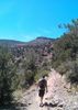
| no partners | | TRAILS: Looped & Connected - #316,317,318,322,367,326
This was a good solid hike. Went yesterday, which was a Sunday. Arrived at about 11:30AM, and the main Thumb Butte Rec. Area parking lot was full. The day fee is $5, with the exception of Wednesdays... Which = FREE DAY in all the Prescott Nat. Forest Parks... BUT, on this Sunday I have the "Prescott Take a Hike" Thumb Butte Pass... YEA!!! Which in turn = NO FEE FOR ME! :GB:
Anyway... Fantastic day for a little hiking excursion!!
Lucy and I headed off onto 316 and made our way back to 317 looping back to our "Starting point." At this point, we continued up 318 - Which at first is a gradual incline with lots' of loose rocks... When reaching even ground, there are a number of burn out spots... This has got a very secluded feel to it, and there isn't a lot of pines or trees... Sunny. (Saw a tarantula crossing the path:-) Not anyone around, even on a Sunday! We ended off this trail by hopping onto 332S. Which is just a skip to 367. (Cross Thumb Butte Rd. here) This trail pretty much follows the road all the way to an exit/beginning point. I kept going here and shortly reached the 326 connector. This led us all the way back to the main parking lot.
Sat down for a few, drank some more H2O, gave Lucy a jerky treat, then we finished up by hitting #33....
A good day of hiking fun 
And for a Sunday... The trails I took were EMPTY!! In total on 316 and 317 I saw two people, 318 NADA, 322,367 NADA, 326 One couple. |
| _____________________
| | |
|
|
|
 Route Editor