|
| | | |
| |
|
| Backpack | 41.00 Miles |
7,000 AEG |
| | Backpack | 41.00 Miles | 3 Days | | |
| 7,000 ft AEG | | 40 LBS Pack | | |
|
|
| |
| Partners |
|
none
[ show ]
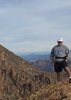
| no partners | | From Pine, took the Highline east to a nice camp at Geronimo creek. The next day I continued to the Washington Park TH, up the old rd and reached the rim via the Col Devin Trail.
Then it was hiking along the general crook trail, which is almost entirely the rim road, to lee johnson spring, headed down here and this is where it got interesting. Despite what mytopo claims, the east webber trail doesn't reach the rim. It does, however, have one really tough obstacle. I don't know how Joe did this with the Eagle, but right now it's about a 5.7 move on wet sandstone. I thought I might break an ankle. After this there are a few other obstacles but nothing major until you reach the slickrock "spring" area. After this is a half mile gauntlet of blackberry brush and cliff rose, along with a ton of deadfall and even a rockslide. Somewhere in upper East Webber I lost my hiking pole. Maybe someone will find it someday.
Scared up 2 elk and made it to West Webber creek where I realized there are no established campsites anywhere along that trail. The next day I went up to Milk Ranch point and down Donahue and made it back to the TH. |
|
Wildflowers Observation Light
Light in general, but really amazing displays of purple flowers near Geronimo Creek and East Verde Creeks. |
|
  |
Red Rock Spring |
Dripping |
Dripping |
| | | Both the spring and the spring box had water, neither looked very appetizing. |
 |
Turkey Spring |
Dry |
Dry |
| | | Springbox was dry (and broken) did not investigate the actual spring |
|
Washington Spring |
Gallon + per minute |
Gallon + per minute |
| | | flowing nicely where you cross on the trail | | _____________________
http://hikearizona.com/garmin_maps.php
Hike Arizona it is full of sharp, pointy, ankle-twisting, HAZmaster crushing ROCKS!!
Hike Arizona it is full of sharp, pointy, shin-stabbing, skin-shredding plants!
Hike Arizona it is full of striking, biting, stabbing, venomous wildlife! |
| | |
|
|
|
 Route Editor