username
X
password
register
for free!
help
ArticlesGuidesRoutes
 
Photosets
 
 Comments
triplogs   photosets   labels comments more
Brody Seep Trail #264 - 4 members in 15 triplogs have rated this an average 1.8 ( 1 to 5 best )
15 triplogs
login for filter options
Apr 23 2022
avatar

 Guides 12
 Routes 192
 Photos 863
 Triplogs 356

42 male
 Joined Nov 30 2015
 Phoenix, AZ
Barnhardt - South Fork Deadman Creek, AZ 
Barnhardt - South Fork Deadman Creek, AZ
 
Backpack avatar Apr 23 2022
ShatteredArmTriplogs 356
Backpack23.00 Miles 5,000 AEG
Backpack23.00 Miles1 Day   2 Hrs      
5,000 ft AEG
 no routes
1st trip
Decided to spend the weekend poking around the Mazatzals again, this time with my overnight gear. I thought I might shoot for Club Cabin. Didn't get started until ~10:30am, but figured I'd have plenty of time. The Barnhardt Superhighway was relatively quick and easy, and got to Chilson Camp in roughly 3 hours. That's where things start getting fun.

Davenport Trail was surprisingly easy to follow all the way to the crossing over of the ridge around which Davenport Trail contours. On the west side, route finding was a little more difficult due to the grass, but the route was well-cairned and overall not terribly hard to follow. I was expecting worse. South Fork of Deadman Creek looked very impressive, had good flow, and it was getting to be past 3pm when I got there, so it was awfully tempting to stop there should I find a usable campsite... And I did, just after crossing over to the west bank (there's only room for two tents, tops, here).

Spent the next hour and a half or so meandering down the creek in sandals, and where it turned around, it was looking almost as verdant as Fossil Creek. This is such a pretty canyon, and I definitely intend to come back and explore more of it, with a little more planning.

Had an uneventful but nice evening, a gusty night, and woke up feeling refreshed for the hike out, which I began around 6:30am. The trail was a little harder to follow in the uphill direction, but I got to Chilson by around 8am. Decided to take Brody Seep trail south to the divide, but after a mile or so the track disappeared into the brush and I didn't feel like dealing with that, so headed back to Chilson.

After that little misadventure we were making good time again, and got to the car by 12:30. Fun time out there, water is still easy to find right now.

water 1 out of 5water less than maxwater less than maxwater less than max Chilson Spring Dripping Dripping

water 1 out of 5water 2 out of 5water 3 out of 5water less than max South Fork Deadman Creek Medium flow Medium flow
Flowing up to and beyond the Davenport crossing.
_____________________
 
Nov 01 2018
avatar

 Guides 3
 Routes 40
 Photos 47
 Triplogs 60

56 male
 Joined Jul 04 2016
 Phoenix, AZ
AZT Passage 23 Fall Brushing, AZ 
AZT Passage 23 Fall Brushing, AZ
 
Volunteer avatar Nov 01 2018
tdwoodTriplogs 60
Volunteer31.00 Miles 6,050 AEG
Volunteer31.00 Miles4 Days         
6,050 ft AEG
 no routesno photosets
1st trip
Partners none no partners
The battle to keep the AZT clear and navigable in the Mazzies continues!

From November 1-4, 11 humans, five goats, and two dogs worked at brush clearing on two separate mile-long sections of the Mazatzal Divide Trail #23; one between the southern junction of Brody Seep Trail #264 and Barnhardt Trail #43; the other segment proceeding a mile north of the northern junction of Brody Seep Tr.

Other accomplishments include signage replacement and maintenance, brushing and tread work at the top of Brody Seep Tr (above Chilson Camp), and removal of old spring works scrap metal from the vicinity of the recently rehabilitated Chilson Spring (no more mud hole :y: )

The weather couldn't have been finer. It's a great time to be up there. If this route is in your hiking plans in the near (or not-so-near) future, I appreciate hearing about trail conditions you encounter.

Thank you to all volunteers everywhere working to keep our trails in shape. If you'd like to learn more about volunteer opportunities on the AZT, visit volunteer.aztrail.org

water 1 out of 5water 2 out of 5water 3 out of 5water 4 out of 5 Chilson Spring Gallon + per minute Gallon + per minute
This source has been rehabilitated and is now a reliable, consistently producing source of water. Some algae present.
_____________________
  1 archive
Dec 20 2017
avatar

 Guides 4
 Routes 491
 Photos 10,890
 Triplogs 1,257

55 male
 Joined Nov 20 2012
 Phoenix, AZ
Davenport Wash Trail to Barnhardt, AZ 
Davenport Wash Trail to Barnhardt, AZ
 
Backpack avatar Dec 20 2017
BiFrostTriplogs 1,257
Backpack33.55 Miles 7,910 AEG
Backpack33.55 Miles3 Days         
7,910 ft AEG
 
1st trip
Early start with Shawn giving me a ride out to Horseshoe Dam area to access the Davenport Wash Trail. Shawn had PM’d me about possible trail maintenance funding for Davenport and needed some information on trail conditions. So I decided to make it 3 days backpacking from Horseshoe over to the Barnhardt trail head.

Day 1 the goal was to make Club Ranch but first I had to cross the Verde River. Sometimes this crossing has very little water or none at all but today it was crotch deep. Of course it was cold and the sun was still coming up so just kept walking to warm up. Fortunately, the first part of Davenport is old road and easy to follow which continues for about 4 miles. Eventually at the wilderness sign it goes to single track and is relatively easy to follow. At about 7.5 miles there is a rocky area with a few cottonwoods that looked promising and sure enough just off the trail in the side canyon there was a nice clear pool of water. Based on how dry it’s been this pool may be reliable even though it’s not marked as a spring. Continuing on passed by Dog Spring and Rock Spring which were both dry but would probably have something with normal winter snow. Soon after the trail drops into Davenport Wash which was also dry and passes a corral before the last mile up to Club Ranch. Within ½ mile of the ranch I lost the trail and ended up in catclaw maze. It was getting late so made it out of the catclaw and camp at Club Ranch. The ranch is about 13 miles from the Verde crossing and very nice spot to call it a night! Good water at Club Spring and reliable any time of year.

Day 2 next morning and well rested I back tracked to see where my mistake was the previous day. Found the trail and pieced together the real track to the ranch. From there Day 2 continued on Davenport Wash Trail and from Club Ranch the trail gets much rougher and difficult to follow. I had been through here a few times before but wanted to see if I could follow the original trail the whole way. About 0.6 miles from Club there is Red Rock Spring which seems to be as reliable as Club Spring with plenty of small pools and some flow. From the spring the trail climbs steeply up the hill but cairns mark the trail over the next 2 miles and could follow the old trail cuts. However, eventually I would lose the trail among some very thick manzanita and scrub oak. Not sure if the trail really exists in this section but I could find occasional remnants in the next mile. Eventually the trail reappears as it drops into South Fork Deadman Creek which would be camp for the night. Although it was dry where the trail crosses I went about 10 minutes downstream and found some nice clear pools to filter.

Day 3 and the temps dropped below freezing over night with some of my water freezing. But it warmed up quickly in the sun and the hike out of South Fork Deadman is about 1000 feet. Another ¾ mile section up slope the trail is difficult to follow but when it tops out there are some cairns and trail cuts visible again. From there it contours over to Chilson Camp and some trail maintenance we did last spring made this last 1.5 mile section easy to follow. Reached Chilson about 130 finally back on good trail for first time in about 10 miles. Followed Mazatzal Divide trail to Barnhardt and out to the trail head.

It was a good recon of Davenport Wash Trail but there definitely are sections probably about 2.5 miles where the trail disappears or is very difficult to follow. It would be great to see it cleared but some of the trail would be a total rebuild instead of maintenance.

water 1 out of 5water 2 out of 5water 3 out of 5water 4 out of 5 Club Spring - Table Mountain Quad Gallon + per minute Gallon + per minute
several clear pools and light flow. Reliable all year water source

dry Dog Spring Dry Dry
completely dry

water 1 out of 5water 2 out of 5water 3 out of 5water 4 out of 5 Red Rock Spring Gallon + per minute Gallon + per minute
several clear pools and light flow. Reliable all year water source

dry Rock Spring Dry Dry
completely dry
_____________________
  1 archive
May 06 2017
avatar

 Guides 38
 Routes 182
 Photos 1,602
 Triplogs 232

40 male
 Joined Dec 09 2014
 Gilbert, AZ
Mazatzal Peak Super Loop, AZ 
Mazatzal Peak Super Loop, AZ
 
Hiking avatar May 06 2017
jacobemerickTriplogs 232
Hiking21.16 Miles 5,374 AEG
Hiking21.16 Miles   14 Hrs   42 Mns   1.88 mph
5,374 ft AEG   3 Hrs   27 Mns Break
 
1st trip
Have you ever wished you could do the Mazatzal Peak Loop and lose a pint of blood at the same time? This alternative on the old classic will deliver!

Barnhardt to Chilson
Not much to say here, did most of it in the dark. Trail maintenance from last year is holding up. Sandy Saddle junction is well cairned and the trail down to Castersen looks reasonable. Finished Barnhardt in two hours, took another twenty to zip over to Chilson Camp.

Brody Seep
Started easy enough, a huge cairn marking a rocky slide down to and over the wash below. Trail was reasonably easy to pick out, tread holding up well and a few cairns scattered about. Some overgrowth will force minor detours. Brody Seep was difficult to reach but well worth it. Above the seep it looks like there were two slides that knocked out a section of trail years and years ago and I ended up bushwhacking for a few hundred terrible yards. FOTG's track shows the correct route to follow. Final leg up to Mazatzal Divide Trail was short and painless, even found some old log steps (somewhat charred) along the route.

Fisher
Junction w/ Brody was difficult to pin down but the tread picks up in a few dozen yards and is easy to follow down to the wash. I tried briefly to pick up the path on the banks and then just followed the wash - assuming hikers from yesteryear did the same thing. This wash makes a sudden, scenic drop and forces the trail to head up a manzanita-and-deadfall choked slope towards crumbling cliffs. Tread can be picked up a few times, but it's easiest just to hack up where possible. Below the cliffs there are some rock slides that seemed to knock out the trail. Picked it up again on the other side and more-or-less followed it along the steep slope until the next wash. Again stuck to the wash, as the banks had manzanita well over my head. Eventually hacked across and found a single lonely cairn in the middle of the next wash, first cairn sighting on Fisher. Then it was a 500' climb through manzanita and deadfall (there's a pattern here), with a faint tread weaving back and forth in tight switchbacks to a saddle. Quick drop and then a 1000' climb up a steep tributary of South Fork Deadman. Didn't even try to find the trail at this point, not with all the pine deadfall, just stuck to the creek and balanced from one log to the next. Found water and a steep waterfall near the fork, no water at Fisher Spring, and a few cairns and traces of path up on the ridge above. Did not find the exact junction with Mazatzal Divide, though I'd guess my path was close to it.

Mazatzal Divide
After a hammock nap at Bear Spring it was time to head north to Y-Bar. After spending the last six miles on "trails?" this felt like a luxury I did not deserve. You know when you are driving on a two-lane country road without a single other car for miles and you purposefully drift between the lanes and feel like a rebel? Yeah, that. Until I almost stepped on a rattle-less snake. Then I stuck to my lane.

Y-Bar
Was a bit overgrown compared to the last year. Plus there were some thorny bits, and the loose rock on the downhill was not pleasant. My knees were also hurting by now so I might be a bit harsh here. The gusty winds did feel good, almost a little chilly. Reached the trailhead with thirty minutes to spare before sunset.

Didn't see a single other person out there on the trails, which was both amazing and a little daunting.

Mazatzal Miles: 85.3/274 (31.0%)
 Named place
 Named place [ checklist ]
[ checklist ]  Bear Spring - Fisher  Brody Seep

water 1 out of 5water 2 out of 5water less than maxwater less than max Bear Spring - Fisher Quart per minute Quart per minute
Full spring, lots of leaking around the base.

water 1 out of 5water less than maxwater less than maxwater less than max Big Kahuna Falls - Mazatzal Wilderness Pools to trickle Pools to trickle

water 1 out of 5water 2 out of 5water less than maxwater less than max Brody Seep Quart per minute Quart per minute
Several large, clear pools that are easy to pull from.

dry Fisher Spring Dry Dry

dry Fisher Tank Dry Dry

water 1 out of 5water 2 out of 5water less than maxwater less than max Hawaiian Mist Light flow Light flow

water 1 out of 5water less than maxwater less than maxwater less than max Windsor Spring Dripping Dripping
Few stagnant pools.

water 1 out of 5water less than maxwater less than maxwater less than max Y Bar Spring Dripping Dripping
Actual marked spring was dry. Another one, few yards to the west, was dripping and flowing across the trail. No good spots to pull/collect from.
_____________________
  2 archives
Mar 17 2017
avatar

 Guides 4
 Routes 491
 Photos 10,890
 Triplogs 1,257

55 male
 Joined Nov 20 2012
 Phoenix, AZ
Davenport - South Fork Deadman Creek, AZ 
Davenport - South Fork Deadman Creek, AZ
 
Backpack avatar Mar 17 2017
BiFrostTriplogs 1,257
Backpack23.00 Miles 3,700 AEG
Backpack23.00 Miles3 Days         
3,700 ft AEG
 no routes
1st trip
Hiked in on Barnhardt Trail to Chilson Camp with the intent to explore the Davenport Wash Trail beyond Chilson. We dropped our backpacks at Chilson and headed out on a trail hunt for Davenport. Right near camp there was a large cairn obscured by manzanita which we cleared out. The tread was faint but definitely there as it contours around hill 6243 marked on topo. Main focus was too follow the trail from Chilson all the way to South Fork of Deadman Creek about 2.2 miles. We continued contouring along the tread we found and clearing some manzanita obstructions along the way. After about one mile from Chilson it was getting late so we headed back to camp.

Next day continuing on the same tread further towards South Fork of Deadman Creek. We made it past the contour section where the trail eventually turns and starts the long descent into Deadman. We were able to follow tread in the first 1/2 mile of the descent but eventually it disappears in a grassy meadow for about 1/4 mile before reappearing just as the trail begins the big drop into Deadman about 1000 feet total. In the steep section down to Deadman there are some trail cuts, old switchbacks and cairns that mark the way down. Finally at the bottom I took some time to enjoy South Fork Deadman Creek which was flowing nicely with cool water and pools.

After snack and break I looked for the trail exiting the other side and there is a faint ramp above the creek but saving that exploration for another time. Recharged from the break headed back up 1000 foot climb retracing the steps and trying to find the missing piece of trail on the hill. After spending about 2 hours in this one section still wasn't able to find any trace of the old tread which is probably too far gone to find but fortunately the terrain is not difficult to navigate. Once back on the old tread I headed back towards Chilson and relax around the fire.

Next day we headed back out Barnhardt which as many have posted before is a super highway right now. The trail crews have done a great job clearing nice wide trail path from Mazatzal Divide Trail junction all the way to Barnhardt TH.

water 1 out of 5water 2 out of 5water 3 out of 5water 4 out of 5 Big Kahuna Falls - Mazatzal Wilderness Heavy flow Heavy flow
lots of water coming off the falls

water 1 out of 5water 2 out of 5water 3 out of 5water less than max Chilson Spring Gallon per minute Gallon per minute
water running across the trail from the spring area

water 1 out of 5water 2 out of 5water 3 out of 5water less than max Hawaiian Mist Medium flow Medium flow
_____________________
  1 archive
Apr 06 2016
avatar

 Routes 10
 Photos 121
 Triplogs 12

47 male
 Joined Mar 19 2012
 Phoenix, AZ
Modified Mazatzal Peak Loop, AZ 
Modified Mazatzal Peak Loop, AZ
 
Backpack avatar Apr 06 2016
AsTheCrowFliesTriplogs 12
Backpack17.46 Miles 3,927 AEG
Backpack17.46 Miles3 Days   6 Hrs   49 Mns   
3,927 ft AEG47 LBS Pack
 
1st trip
Partners none no partners
Well, this triplog is a little behind but I figured I would post it while I have the chance....

It was time for our annual backpacking trip and this time we decided to hike the Mazatzals starting at Barnhardt TH with intentions of Spending two days at Chilson Camp and two days at Horse Camp Seep with a long final day to get back out on Barnhardt. That was until we saw (and experienced) the weather forecast for the next few days. With the thought of hiking out 10 miles in the rain on Sunday we decided at Chilson Camp to hike around the peak back over to Y-Bar Spring for an easier hike out on either Saturday and Sunday....

Okay, enough backstory! Wednesday morning I picked up my friend Shaun who didn't make the beer run a few days earlier and we were off to Claytons. Jerry and Clayton were ready and waiting so we threw their bags in and went to pick up our 5th crewmember, Larry.. With the Kia groaning under our weight (and the 4+ pounds of frozen meat in my backpack) we took off for the 87. Once again we stopped at the house of Ronald McDonald and had some coffee and grease before hitting the trailhead. Good thing I don't go backpacking this direction all the time!

Once at the trailhead we all loaded up and got to it, after I *finally* managed to snap a group photo... It only took about 8 times of setting the timer, adjusting focus, and running to the group. With a 47lb pack on...
Camera 7 - Me 1.

The trail was a little tougher on me the second time around with my "everything and the kitchen sink" packing method but hey, I love roughing it! It also didn't help that at around the 5 mile mark we uncovered our beer from the burnt out stump (https://www.youtube.co...) and I threw another 13 pounds on... That last two miles to Chilson Camp seemed to take forever but I'm pretty sure I actually moved faster just to get the 60lbs off as soon as possible. Good thing I had new hiking shoes and a pack that didn't get uncomfortable with the weight, it was just that my feet didn't want to lift off the ground!

Before we finally made it to Chilson Camp I tried to find the spring via the location on my GPS. It shows it on the right side of the trail about 40' above your location on the trail. Every description I've read said there is a spring box up there and it's where the water goes across the trail. Well, there was no water on the trail so I dropped my pack and hiked up. Found water on the ground and followed it to an 18" or so diameter pipe with a lid. Removing the lid revealed brown mud water about 1" deep..... Discouraged I went back down and grabbed my pack to continue onto camp. Wasn't looking forward to backtracking for the water we saw in the canyon about a mile back. Funny thing is when we got to camp, there was a Homer's bucket with about 20 unopened bottles of water by the table and fire pit.

We got camp all set up and decided to hike back for water before making dinner so we grabbed our pumps and a few of us decided to cut straight up to the trail and avoid having to go north before we could head southeast.... 3 went one way and two went the other... As we were scoping for a clear path to bushwhack, we managed to find a beautiful hole in the ground about halfway up that was full of water :) We finally found the spring but it was nowhere near the GPS coordinates I had. (If you would like to find my coordinates, there is a geotagged photo in the photos section). It took about 15 minutes for the other folks that didn't want to hike up with no trail to finally get above us so we could tell them to come back. They promptly decided to come right down the side in about 2 minutes... Probably should of came with us to begin with!

Anywho, we drank some beer that night and had a good cheeseburger for dinner.. After catching a healthy buzz we caught some sleep and were woke up about 2am to a nice rain on our tents.. Next morning Jerry discovered his tent was not waterproof... Good thing we hung tarps above us beforehand!

On Thursday we cooked some breakfast and hiked down the Brody Seep trail for a bit and shot west to check out some pools of water in a nice V rock formation.. There was little trail so we followed the creek bed. This should have been a good notion for us to not go this way on Friday when we hiked to Y-Bar but I will get to that madness in a bit.... We drank a few beers and hiked back to camp to be lazy the rest of the day. Later, while we cooked dinner, a thru hiker on the Arizona Trail stopped in and asked if he could set up camp by us which was fine by us. His name was Mike and you can read his excellent blog here: freeroamingphotogra ... amp/ After filling up on a massive steak, potatoes, sweet peppers, and mushrooms, it was time to finish off the rest of our beer to lighten the load the following day. We also decided at this time to not go up to Horse Camp Seep, instead we would head to Y-Bar and spend one day there instead of two. With all the rain, we didn't want to be hiking out on Sunday when it was raining.. When we went to bed we had the notion we would sleep in, cook breakfast, and head out around noon. This was a bad idea...

So... Friday morning we woke up and took our sweet time getting ready. While we ate our breakfast Larry and Clayton decided we should take the Brody Seep trail back to AZT rather than backtracking on the Barnhardt trail to the AZT.. After what we had learned so far, we should have said no... But we went anyway. We left about noon and it was started to get cloudy and sprinkling a little bit. The trail on the way to Brody Seep was pretty hard to follow and I'm pretty sure we were on it only about 10% of the time. As we closed in on Brody Seep the going got worse and we could not find a clear trail anywhere. The amount of felled trees was crazy to say the least. I was a little ahead of the group and came to a *very* steep incline with no indication of a trail. In the end it started raining and I decided to just power up the hill. I had to grab whatever I could to pull myself up very slowly. I think it took me about 30 minutes to get up about 300' in a 10th of a mile. Once up I finally found the trail and it started raining a little. I dropped my pack and headed down the trail only to have it disappear. I switchbacked a few times on my own avoiding the vegetation and finally found the group after quite a yelling fit.. They were still at the very bottom of the hill and only Shaun was on his way up. I made him come to me and then I headed back to my bag to put my rainfly on it as it started pouring (and hailing) on us. Long story short, this little ordeal cost us about 3 hours of time to get everyone to the top.... After that the trail was decent enough but it was a steady uphill most of the way to Y-Bar spring. We passed it by and found an excellent camp... It was a very long day and we were all ready to eat and rest.

Sidebar, on our way we were expecting to find a branch in the trail to Y-Bar Tanks... Where the heck is it at? We could not find it at either end!

After we set up camp that night we really wanted another beer but we were running low on water. Most of us had Pat's Backcountry Brew's but it took water to make it... I was pretty filled up after a roast beef sandwich and some beef stew so I volunteered to go with Clayton and Larry back to Y-Bar Spring. I had a new water filter in a bag and was ready to try it out! After the quick quarter mile hike I dropped my bag under a small waterfall and filled it up.. Didn't take long to have 10L of water. Larry and Clayton used UV treatment on Nalgene bottles and the light was so bright moths kept flying into the water. After we got back I made a few flat beers (Larry has it down, the rest of us suck) it was time to pass out. We watched the sky go back and forth from bright stars to dark clouds and were pretty confident we should head out the next day.

Saturday morning we woke up and made some breakfast. I had Spam and a Mountain House dehydrated biscuits and gravy which was pretty awesome I must admit :) We were out of camp fairly early and on the way back via Y-Bar I'm pretty sure everyone in the group was thinking we were making the right decision by leaving a day early. The trail back was fairly steep going downhill and I'm sure no one wanted to do it in the pouring rain. We were back at the car by 2pm or so and decided to stop for a drink on the way home. I'm pretty sure we scared a little with our stench at Circle K.. Good thing I couldn't smell myself :)

Sunday around noon there were a flurry of text messages from everyone stating they were glad we left a day early because it was pouring rain! Fun trip, can't wait to check out more of the Mazatzal's!
 Culture
 Culture [ checklist ]
[ checklist ]  Campsite  HAZ Food
 Named place
 Named place [ checklist ]
[ checklist ]  Chilson Spring
wildflower observationwildflower observationwildflower observationwildflower observationwildflower observation
Wildflowers Observation Isolated

water 1 out of 5water less than maxwater less than maxwater less than max Big Kahuna Falls - Mazatzal Wilderness Pools to trickle Pools to trickle

water 1 out of 5water less than maxwater less than maxwater less than max Chilson Spring Dripping Dripping
Couldn't find the location on the map. Spring was actually closer to camp.

water 1 out of 5water 2 out of 5water less than maxwater less than max Y Bar Spring Quart per minute Quart per minute
_____________________
  2 archives
Mar 14 2015
avatar

 Guides 41
 Routes 1,626
 Photos 14,983
 Triplogs 2,760

69 male
 Joined Jan 20 2009
 Far NE Phoenix,
Trans Mazzy - East to West, AZ 
Trans Mazzy - East to West, AZ
 
Hiking avatar Mar 14 2015
The_EagleTriplogs 2,760
Hiking23.85 Miles 4,188 AEG
Hiking23.85 Miles   14 Hrs   27 Mns   2.05 mph
4,188 ft AEG   2 Hrs   50 Mns Break16 LBS Pack
 
1st trip
Partners partners
BiFrost
fan3992
joebartels
JuanJaimeiii
topohiker
This one's been in the thought / planning stage for more than a year.
Once the logistics of
:next: covering aprox 24 miles,
:next: on a day that Horseshoe Dam was closed (ie Verde cross-able w/ vehicle),
:next: decent weather,
:next: with a group of 6 to 10 hikers,
:next: in an area few have ventured recently,
:next: on a trail that is non-existent in places
was determined, it all fell into place.

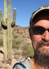
We were thwarted 2 weeks ago by weather and our group dropped from 10 to 6. This was a key swap, since I figured it would take about 8 hours to set up and rip down a shuttle. JJ, Joe, Karl started on the Davenport Wash Trail, from the west at the Wilderness border, Ken, Fan and myself from the East at the Barnhart TH.

Temps were mostly nice on the day. Starting at 55, hitting mid 80's and ending, for us, at 72. Scattered clouds and a breeze help immensely during the day.

Hawaiian Mist and the Big Kahuna Falls were flowing decently on the way up the Barnhart Trail.

Passing the campsite just west of the intersection with the Mazatzal Divide Trail, some idiot backpackers neglected to put out their campfire and left cans from their meal in the fire. We covered it the best we could with rocks to keep it contained, not knowing when we'd get to our next water source for replenishment.

On our way through Chilson Camp we stopped and chatted with the guys camping there. A few were forest service workers out enjoying the weekend.

The views West of Chilson Camp, were pretty big. Table Mountain was the prominent peak, with numerous canyons around the South Fork of Deadmans Creek and Davenport Creek, supplying interesting views.

Now the fun begins. To this point we were on established trails. The Davenport Wash Trail from Chilson Camp to Club Cabin, has some issues. With a GPS track (Highly Recommended), you can navigate your way.

Climbing out of the South Fork of Deadmans Creek, we met the easterly traveling speedsters. We chatted for a brief moment, but I could tell that JJ's motor was running. Cue smoke, speedsters gone into a cloud dust.

From East to West, the worst section for us was betwen miles 11.5 - 13.25 (5000' to 4400'). Where we hiked, was in spots, through extremely thick brush.

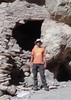
At Club Cabin we topped off our water and had some lunch. Only 12 miles to go and it was 4:45pm.

At dusk we saw 2 rattlers about 5 minutes apart from each other and then spied a fox. We had a bit of trail finding issues in the dark, but made it back to Ken's Jeep, thankfully parked at the Wilderness boundary. A long, fun, challenging day.

Thanks to Richard for being a sounding board on a few issues, and
a Big Thanks to Ken :app: and Karl :app: for driving, and JJ for the Pizza. ](*,)

Video :next: https://youtu.be/_U ... uu74

** Of Note ** HAZTracks ran for 14+ Hours (Android - Galaxy S5) before the cell phone died 1/2 mile before we finished.
Cell was also on for the two hour trip to the TH. (16+ hours total)

I think that one is out of my system now....
.....do I dare start planning the next long distance Mazzy adventure that's been bugging me the last couple of years to do? It too will probably need to be a key swap. ;)
wildflower observationwildflower observationwildflower observationwildflower observationwildflower observation
Wildflowers Observation Moderate

water 1 out of 5water 2 out of 5water 3 out of 5water less than max Big Kahuna Falls - Mazatzal Wilderness Medium flow Medium flow
Plenty to filter

water 1 out of 5water less than maxwater less than maxwater less than max Chilson Spring Dripping Dripping
Water was across the Trail, but did not climb up to check the source.

water 1 out of 5water 2 out of 5water less than maxwater less than max Club Spring - Table Mountain Quad Quart per minute Quart per minute
Plenty to filter

Also Davenport Wash had plenty of water to both the North and West of here

water 1 out of 5water 2 out of 5water less than maxwater less than max Hawaiian Mist Light flow Light flow
Plenty to filter

water 1 out of 5water 2 out of 5water 3 out of 5water less than max Red Rock Spring Gallon per minute Gallon per minute
Did not check out spring, but area downstream at Davenport Wash Trail was flowing and appears to be perennial.

water 1 out of 5water 2 out of 5water less than maxwater less than max South Fork Deadman Creek Light flow Light flow
Where we crossed at the Davenport Wash Trail, there was plenty to filter.
_____________________
There is a very fine line between "hobby" and "mental illness."
Dave Barry 🦅
 
Nov 07 2014
avatar

 Guides 4
 Routes 491
 Photos 10,890
 Triplogs 1,257

55 male
 Joined Nov 20 2012
 Phoenix, AZ
Mazatzal Divide-AZT#23 & Red Hills-AZT#24, AZ 
Mazatzal Divide-AZT#23 & Red Hills-AZT#24, AZ
 
Backpack avatar Nov 07 2014
BiFrostTriplogs 1,257
Backpack38.79 Miles 6,035 AEG
Backpack38.79 Miles3 Days         
6,035 ft AEG
 
1st trip
We wanted to do the Mazatzal Divide AZT #23 and Red Hills AZT #24 together so with that plan in mind we decided to make it 3 day backpack. However, before we could start the car shuttle had to be completed which involved dropping a vehicle at Doll Baby TH and then driving around to Peeley TH. After the long shuttle we finally started very late at 10am.

Out of Peeley TH the trail is decent with about 700 foot climb but the trail gets a lot rougher after 3.5 miles. The section between there and Bear Spring is pretty tough by AZT standards and much of it still recovering from fire damage. The trail tops out at about 7200 before dropping down to Bear Spring which we reached just before 3pm. We took a break and filled up on water with the good condition of the spring. Heading over from Bear Spring the trail definitely improved especially after Y Bar saddle near Windsor Spring. From there we headed down towards Chilson Camp for the night but with time against us we didn't arrive until almost 7pm. Regardless Chilson was a welcome sight and we really enjoyed the night and good fire.

Next morning we started somewhat earlier at 830 and headed towards Horse Camp Seep but stopped by the Deadman Falls overlook. The drainage at the overlook had several pools with good water just below where the trail crosses. We checked out Horse Camp Seep after that which had decent water as well in pools and the seep. Then it was on to Hopi Spring which is not the easiest to find with all the burn damage but it did have some cloudy water that was filterable. Later we found out that we missed Chumley and FOTG at Hopi Spring by about 40 minutes. We left shortly before they arrived and headed over to The Park were we had lunch. The Park is a great area that we didn't really have time to wander around since we had to make camp another 5 miles down trail. Now on the Red Hills section out of The Park the trail goes over a couple of climbs about 300 and 400 feet each. Trail then tops out before dropping back down into a drainage called the Seeps of the Red Hills Trail. There is a good section of pools here so we found a camp spot this time before dark:)

Another nice camping night with nearly full moon and again headed out in the morning around 830. Trail goes by some decent pools as it follows the drainage out of the bottom. Not sure how long the pools will last but some were pretty deep and would take awhile to dry up. After that we topped out and hiked across the mesa over to where it drops down to Brush Spring. Trail drops about 600 feet to Brush Spring which has some nice camp spots. The spring was a little tougher to find but it's about 200 feet above where the trail crosses the drainage. Lots of brush to fight through but assuming it's reliable the spring looked good considering how dry everything looked. We took a break before heading up the hill to the next saddle which overlooks the East Verde Valley just before dropping down. You can see the LF Ranch from this saddle but it's a long way down and over 5 miles still to go.

Another quick break and headed down the steep descent. Trail condition is rough and needs some work but appears to be the patchwork of old mine roads. After a warm descent we made the ranch a bit after 3pm. Kathy and I wanted to check out the East Verde and finish the section while the other member of our group went to see if he could score a ride to Doll Baby TH. Made it to the river and took a few pics...no problem crossing at the ford for the start of the next section of AZT. Then headed back to the road by the ranch just in time to hear a vehicle. Mary Ann the owner of the LF Ranch was gracious enough to give us a ride to Doll Baby TH. Riding the road we could see what people mentioned in previous triplogs about the hill on the road. It's an aggressive climb and would have put us at the vehicle after dark for sure. Really happy Mary Ann gave us a ride:) Awesome to get these two sections done together as a backpack!!
 Culture
 Culture [ checklist ]
[ checklist ]  Cairn

water 1 out of 5water 2 out of 5water less than maxwater less than max Bear Spring - Fisher Quart per minute Quart per minute
small pool in the concrete box but good clear water

water 1 out of 5water less than maxwater less than maxwater less than max Hopi Spring Dripping Dripping
water was cloudy but could filter if needed

water 1 out of 5water 2 out of 5water 3 out of 5water less than max Horse Camp Seep Gallon per minute Gallon per minute
good pools and seeps with plenty to filter
_____________________
  1 archive
Oct 11 2014
avatar

 Guides 37
 Routes 556
 Photos 10,872
 Triplogs 1,052

43 male
 Joined Jan 21 2013
 AZ
Barnhardt to S. Fork Deadmans, AZ 
Barnhardt to S. Fork Deadmans, AZ
 
Backpack avatar Oct 11 2014
FOTGTriplogs 1,052
Backpack26.06 Miles
Backpack26.06 Miles2 Days         
 no routes
1st trip
My fall break dedicated to hiking brought me to the Mazzies for my final two days. My only real plan was to stay at Chilson Camp and try to locate some lesser traveled trails in the area for some future back packs and mega day hikes. Karl and Kathy were late additions to hike and could only day hike in Saturday. However, it worked out perfect for my plans as Karl had an interest in the same trail and area as me.

The hike into Chilson Camp was great! The major Falls were flowing, Barnhardt Canyon was roaring, the weather was cool and we made pretty solid time considering I was lugging a slightly heavier pack. From Chilson I hung my gear and switched to my day pack for some pretty rugged "on-trail" exploring. Kathy passed on our trail finding mission and headed up the AZT Trail.

We were actually able to locate the beginnings of Davenport Trail pretty easily and were both surprised at how easy it was to follow despite being over-grown, the victim of several dead fall areas, eroded, steep and rocky. We were able to stay generally on trail until probably the final three to four tenths drop into the South Fork of Deadman's Creek. The hillside is badly overgrown with waste high grass, the footing was not so great, and it was really steep. We did locate the section of trail we had missed on way out. However, on way in the few feet we were off-trail were very rough and probably the roughest and most stressful of day. Mainly because the dogs were long over-due for a water break and I was getting frustrated by the complete lack of trail, or in hindsight my inability to find trail. But as usual the reward was well worth the small struggle as the S. Fork was flowing strong complete with cool little cascades and small swimming holes. The dogs definitely enjoyed the destination and we were both happy to knock out a seldom traveled section of the Davenport Trail.

We got back to Chilson just after three. Chatted it up a bit with Kathy and Karl and then they hit the trail; I began my regular camp routines. The only drawback was water, the dead lizard in my initial source of water eventually led to a quarter mile detour down Brody Seep where the wash was pushing some crystal clear cold rain water, a longer walk, but much better alternative.

Perfect outdoor sleeping conditions. I woke up and went down to the Falls area along the N. Fork. All of the major washes and creeks were still flowing strong along with Deadmans. I know this area is capable of holding much higher levels of water and the Falls only get nicer with more rains and snows. However, the modest amount of run-off in the Mazzies this weekend really transformed the area, a sharp contrast to my previous July visits!

After my short morning hike, my hike out was pretty uneventful. It was nice to have water the whole way for the dogs and Barnhardt felt like a highway after a day of following Karl ;)

The Mazzies capped off a very productive fall break that also included the Primitive Blue Range and Eastern Supes not exactly the easiest terrain and trail to rack up 70 plus miles. In hindsight, I may have been able to squeeze in one more trip, but no worries, Christmas break is right around the corner ;)
 Culture
 Culture [ checklist ]
[ checklist ]  HAZ - Hike HAZard
_____________________
  3 archives
Oct 11 2014
avatar

 Routes 67
 Photos 966
 Triplogs 694

51 female
 Joined Jan 05 2012
 Phoenix,AZ
Barnhardt to Deadman's Falls, AZ 
Barnhardt to Deadman's Falls, AZ
 
Hiking avatar Oct 11 2014
slowandsteadyTriplogs 694
Hiking19.61 Miles 3,119 AEG
Hiking19.61 Miles   12 Hrs   26 Mns   2.22 mph
3,119 ft AEG   3 Hrs   35 Mns Break
 
1st trip
Partners partners
BiFrost
FOTG
We had been pretty noncommittal for what our hike would be this weekend. I don't have a huge desire for offtrail route hunting but if I get to do Barnhardt and then enjoy myself in the Mazatzals, then I am in!

Barnhardt never disappoints, and seeps were runny and the falls were flowing. I like this trick of us carrying day packs and Lee carrying the heavy camping gear, then I don't feel so slow. :D Blanco kept an eye on me. I'd see him up ahead peaking around a corner at me, then he would take off to catch up to the guys.

We went down to Chilson Camp for a break and then off to our own adventures. I went back up to the Divide Trail and just lollygagged along. I hiked with my head up and enjoyed the views! At two miles from the Brody/Chilson turn off, you cross a creek. The water was flowing crystal clear. I continued on, and then thought I could hear a waterfall. I went off the trail and followed the sound heading back the way I had come. Suddenly, I realized I might be looking at Deadman's Falls. If I had just headed down that creek about a tenth of a mile, I would have found it. Perfect spot for another break.

I headed back to Chilson and used the picnic table there to eat some snacks and read my book and enjoy the afternoon. Karl and Lee returned and we exchanged tales and then Karl and I headed out. One of these times we might actually stay to enjoy the campfire!
_____________________
 
Oct 11 2014
avatar

 Guides 4
 Routes 491
 Photos 10,890
 Triplogs 1,257

55 male
 Joined Nov 20 2012
 Phoenix, AZ
Barnhardt to S. Fork Deadmans, AZ 
Barnhardt to S. Fork Deadmans, AZ
 
Hiking avatar Oct 11 2014
BiFrostTriplogs 1,257
Hiking19.99 Miles 4,209 AEG
Hiking19.99 Miles   11 Hrs   55 Mns   2.03 mph
4,209 ft AEG   2 Hrs   5 Mns Break
 
1st trip
Partners partners
FOTG
slowandsteady
We decided to do a quick recon on Davenport Trail #89 from Chilson Camp via Barnhardt TH. Lee was doing a backpack but we only had time for a day hike so we joined him for the hike in. From Chilson Lee and I tried to follow the Davenport Trail west towards South Fork of Deadman Creek. While Kathy went up the Mazatzal Divide to enjoy the falls around North Fork of Deadman Creek. Pretty sure she got the better hike but we were determined to recon the condition of Davenport Trail. First mile of the trail we could follow, but the next mile and a half was very difficult to follow. This area was burned badly by the Willow Fire in 2004 with no attempt at trail maintenance since then. We would see the occasional cairn for the trail but no evidence of one. The last 1/4 mile down to the creek is really steep and fortunately we were able to pick up remnants of the trail. After relaxing around the creek I hiked maybe another 1/2 mile past the creek to see the trail condition. First 1/4 mile is ok but after that the trail is pretty much gone again. The recon was a good first attempt with the ultimate goal getting to Club Cabin but based on trail conditions it would be a long slog for sure.

We hiked back to Chilson Camp and linked up with Kathy. She reported that the side drainages into North Fork of Deadman Creek were running strong...would have been nice to see but the recon took priority on this outing. After hanging out at Chilson with Lee for a bit we headed back down Barndhardt to the TH. Interesting to see Davenport Trail again and definitely have to go back to check out the rest of the trail to Club Cabin.
 Meteorology
 Meteorology [ checklist ]
[ checklist ]  Rain  Rainbow  Sunset
_____________________
  3 archives
Jul 13 2014
avatar

 Guides 37
 Routes 556
 Photos 10,872
 Triplogs 1,052

43 male
 Joined Jan 21 2013
 AZ
Y Bar Sandy Sandy Saddle Barnhardt Loop, AZ 
Y Bar Sandy Sandy Saddle Barnhardt Loop, AZ
 
Hiking avatar Jul 13 2014
FOTGTriplogs 1,052
Hiking18.66 Miles 4,641 AEG
Hiking18.66 Miles   8 Hrs   13 Mns   2.42 mph
4,641 ft AEG      30 Mns Break
 
1st trip
Today was just a relaxing 18 mile jaunt through the Mazzies. However, before going over details of latest venture into an area that is quickly finding itself near the top of my favorite areas to go list, I would like to give a personal thanks to Mazatzal or Richard to most I assume.

In my infancy on HAZ one day back in November I had a PM titled "Thunder Guy New Ideas." It was after I had completed my somewhat bittersweet quest to hike every mile of every trail (not counting tourist traps) in the Supes. The theme of the PM can be summed up with this quote from Richard.

you should take look at the mazatzal wilderness. It is a wonderful place and way more remote and challenging (referring to Supes) but so rewarding to those willing to do arduous backpacks.


I will be 100 percent honest the Mazatzal Wilderness was not even on my radar at that point. However, he had me sold with the use of the words "remote" and "challenging." Since his PM I have not gone crazy in the Mazzies. Yet, I feel that between Twin Buttes, the Gorge, Deadman Mesa and more recently some areas off Barnhardt I am slowly earning my Mazzie stripes. With each hike and backpack I am left wanting more, and I can't wait to really tackle this wilderness in the cooler wetter months. It was a great lead to a new hiking area for me and I am very grateful for that. I should also mention that I bother Kyle about ten times a week with questions and crazy ideas leading up to these Mazzie trips as well. He has also been a great asset and I know he shares a similar affinity for the area. We just have to get out there together for something epic Kyle, let's make that happen come Fall.

Now back to today's hike.

Going with Joe's model for this one.

Y-Bar: Great trail! Aside from waterfalls that I have yet to see I would put this above Barnhardt actually. Can't go wrong with the little ponderosa forest and trail was in great shape, easy to follow. Felt a little lethargic and fatigued early on, was still working out some lactic acid from a good leg work out on Thursday.

Mazatzal Divide Trail: Easy sailing, easy to pick up far in distance, a couple of overgrown areas near some side drainages, damn that New Mexican Locust can really swallow a trail in a hurry! I hope I am using correct term for that devil tree/plant.

Brody Seep Trail: Only mistake I made all day. I should have listened to the hike description author's suggestion of taking slightly longer route to Chilson Spring area via Mazatzal divide. However, the small silver lining is I think I have identified the starting off point for the elusive Fisher Trail.

Sandy Saddle Trail:
Thank you NONOT for that great official route! It was spot on! Not the greatest trail, but I love a little challenge, and some rumors of its demise may be slightly exaggerated. However, I would recommend pants in lieu of Nike running shorts..sigh..Sandy Saddle is main attraction, actually a nice little area, perhaps future camp site for this guy, but overall, I don't think most would want to make it a special point to do this trail.

Barnhardt Trail Joe's Falls are probably more similar to a leaking faucet right now, however, enough water to keep a guy alive, soak your hat, head, satisfy the pups or drown someone with a little effort. ;) Dark humor sorry, its an infantry thing.

Plenty of water in canyon adjacent to trail, actually flowing strong in spots, but as an ECON teacher I applied the Law of Diminishing Returns and did a little cost benefit analysis of the situation and scrambling down the steep banks for the sake of a quick swim was not worth it to me today.

No Blanco no Cup today, I think the heat and lack of water may have even got to Blanco today and he is resting up for a quick turnaround to Primitive Blue Range on Wednesday. Likewise, as much as it pains me to say, I am not so inhibited when I go solo and I can really crank out quality miles at a much quicker pace, so it was probably for the best today.

Consumed a lot of water, donated about a half a pint of blood to wilderness Gods and for a third week in a row finished to some nasty thunder and lightning. I am starting to feel like a storm chaser, except the storms are chasing me! :o

Final Note: Bring on this "Midnight Mesa Loop" I hear of...I am ready!...well I think I am anyways ;)
 Flora
 Flora [ checklist ]
[ checklist ]  Poison Ivy
 Geology
 Geology [ checklist ]
[ checklist ]  Maverick Shale
 Culture
 Culture [ checklist ]
[ checklist ]  HAZ - Hike HAZard
_____________________
  2 archives
Feb 26 2012
avatar

 Routes 67
 Photos 2,708
 Triplogs 755

89 male
 Joined Mar 28 2008
 Phoenix, AZ
North Fork Deadman Falls via Barnhardt, AZ 
North Fork Deadman Falls via Barnhardt, AZ
 
Hiking avatar Feb 26 2012
Tough_BootsTriplogs 755
Hiking19.50 Miles 4,112 AEG
Hiking19.50 Miles
4,112 ft AEG
 no routes
1st trip
Partners partners
John9L
I wanted to check out the North Fork Deadman Creek twin falls again. I figured it was a gamble since there would be a good chance they aren't flowing right now but even the view from the top is worth the hike. John hasn't hiked in the Mazzies before so he was game to get out there.

We got an early start and were at the Barnhardt TH by 7:15. We visited the falls along the trail which were flowing. I've seen them show much better but those falls are always cool. Soon we were back on the trail. There was also water in the little canyon between the Divide junction and Chilson Camp. I have no clue what its called but there's almost always filterable water in there.

We then ran into the only person we saw all day-- a solo backpacker on the Divide Trail. We talked for a few minutes and were then on our way. I would later be shocked that he was the only person we ran into all day. Barnhardt TH on a sunday?

From there on, there was a little bit of water on the trail so I was hopeful there would be some at the falls. We finally made it to Sandy Saddle wash and it appeared dry. We worked our way down to the falls and started seeing more and more clear, deep pools along the way. We made it the falls and they were both flowing! Well, it wasn't like last year when I saw them with all the HAZ folks-- but they were both flowing with nice big pools at the bottom of the canyon. It was definitely worth the hike out there. That drop is dramatic to say the least. We ate lunch and headed back.

This being John's first time out there, I fooled him into checking out the Brody Seep trail by telling him about Chilson Camp. I had never been on Brody Seep past the camp and was wanting to check it out and diversify the return hike. My plan was to take Brody Seep and hit the Divide farther south and make a little loop back to the Barnhardt Trail. The Brody Seep did exactly what I expected it might do-- it fades in and out and completely disappears in spots. The trail map overlay I have on my GPS (nonot's map)shows a trail intersecting about halfway down the Brody Seep labeled Barnhardt West. John has Garmin's maps on his GPS that shows the Brody Seep (unlabeled) but instead of showing it continue south, has it follow the same trail I have labeled Barnhardt West (if anyone has more info on this section of forgotten trail, I'd be interested).

Well, anyways... the intersection of these two trails is cairned and fairly obvious. We figured that both trails were probably going to be a total mess but we'd take Barnhardt West because at least it was more direct. After a while, that trail completely disappears and never comes back-- no cairns or nothin'! We tried to follow fairly close to our tracks for a bit and then when we realized we were getting closer to the Divide Trail, we just bushwacked the most direct route and ended up fairly close to Barnhardt/Divide junction.

We were glad to get back on a trail and we made good time back to the TH.
_____________________
 
Feb 26 2012
avatar

 Guides 6
 Routes 183
 Photos 5,612
 Triplogs 1,647

male
 Joined Mar 12 2004
 Scottsdale, AZ
North Fork Deadman Falls via Barnhardt, AZ 
North Fork Deadman Falls via Barnhardt, AZ
 
Hiking avatar Feb 26 2012
John9LTriplogs 1,647
Hiking19.50 Miles 4,112 AEG
Hiking19.50 Miles
4,112 ft AEG
 no routes
1st trip
Partners partners
Tough_Boots
Kyle pretty much summed up the entire hike in his trip report. I just want to add it felt great getting in all the miles and AEG. To make a long story short I ended up with Hernia back in late October and was out of the hiking game while I underwent surgery and started my recover. There were days in which I never thought I would do a day hike like this again. In the past six weeks I quickly regained my strength and confidence. This hike proved that I am 100% recovered and ready for anything!

This hike was amazing and the waterfalls were impressive. The view looking over the edge was a rush. I really enjoyed the solitude as well. I still can't believe we only saw one person the entire day! All in all it was another great day on the trails and I'm already looking forward to the next big hike! It's gonna be a great year!
 Named place
 Named place [ checklist ]
[ checklist ]  Deadman Canyon Falls - North Fork
_____________________
 
Mar 09 2003
avatar

 Routes 36
 Photos 2,658
 Triplogs 1,347

67 male
 Joined Jul 28 2004
 Scottsdale, AZ
Barnhardt Trail #43Payson, AZ
Payson, AZ
Backpack avatar Mar 09 2003
mazatzalTriplogs 1,347
Backpack28.00 Miles 4,160 AEG
Backpack28.00 Miles3 Days         
4,160 ft AEG
 no routes
Partners partners
jhelfers
Day 1: Barnhardt to Chilson. About 1/4 mile past Sandy Saddle junction we hit 2 feet of snow and we were postholing (mid thigh) for the next mile and a bit to the Divide - that took us almost 2 hours!

Day 2:Chilson to Davenport Wash (just past Club Cabin). We had some trouble getting across South Fork Deadman Creek due to really high flow (dangerously high with big packs) but we managed it.

Day 3: Hiked out to Davenport TH and then 7 more FR miles to the Dam.

Another great Mazzie trip :D
_____________________
  1 archive
average hiking speed 2.12 mph

WARNING! Hiking and outdoor related sports can be dangerous. Be responsible and prepare for the trip. Study the area you are entering and plan accordingly. Dress for the current and unexpected weather changes. Take plenty of water. Never go alone. Make an itinerary with your plan(s), route(s), destination(s) and expected return time. Give your itinerary to trusted family and/or friends.

helpcommentissue

end of page marker