|
| | | |
| |
|
| Hiking | 19.52 Miles |
3,612 AEG |
| | Hiking | 19.52 Miles | 10 Hrs 30 Mns | | 2.05 mph |
| 3,612 ft AEG | 1 Hour Break | 16 LBS Pack | | |
|
|
| |
| Partners |
|
[ show ]
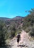
| partners | | It's been far too long since I've hiked out of Spur Cross. Especially since I live so close to it. There was a 70% chance of rain on the day, and with rain for two days previous, Cave Creek was sure to be running decently.
7:30 in the morning, and we were the first vehicle in the lot. We kept our feet dry by rock hopping the 1st and 4th crossings and going off trail to bypass crossings 2,3 5 and 6. I'd forgotten how steep it was in sections of Cottonwood #247 trail, just to get to the steeper Skull Mesa #248 trail. It was a temperate 55 degrees, but I was wringing wet and glasses fogging up from all the humidity.
Once on top of Skull Mesa, we made our way on the Skull Mesa "Trail" to the east side. The western portion is cairned and easy to follow. The eastern portion, not much to follow there. Still the rain held off, but we had periods of fog on top, and then rising fog from below as we started down.
35 seconds of sheer excitement  http://youtu.be/xii8-a... http://youtu.be/xii8-a...
The top of the mesa was pretty muddy, our shoes picking up extra weight along the way.
On the Quien Sabe #250, we decided to take a short cut to Cave Creek #4 down a wash. There some sweet geology and flora along the way. On Cave Creek #4, we got our first sprinkles of the day. Not enough to to put on the coat or break out the chrome dome.
We cut off Cave Creek #4, down to the 6L ranch area, on a spur trail. I'd never been here or read too much about the area. This is a nice area the I need to come back and check out. We stumbled upon some Glymps and Metates and it looks like there much more to see here.
Getting back from here was easier, since we no longer had to try and keep our feet dry, we just walked on through all the creek crossings
The Metate Trail and Towhee Trail are always fun to hit when in the area. Some of the biggest Saguaros in the state, mixed with all sorts of greenery |
|
Wildflowers Observation Isolated
|
|
| _____________________
There is a very fine line between "hobby" and "mental illness."
Dave Barry  |
| | |
|
|
|
 Route Editor