|
| | | |
| |
|
| Backpack | 53.12 Miles |
9,968 AEG |
| | Backpack | 53.12 Miles | 5 Days | | |
| 9,968 ft AEG | | | | |
|
|
| |
| Partners |
|
[ show ]
| partners | | Chris and Sam had a couple of cancellations on their permit and extended the invitation a month or so ago. Ignoring the manmade point in the revolution of the planet around the sun doesn't seem to phase me much. But I guess that's what the whole plan was. Turns out to be my most memorable random point-passing since that time when all the computers stopped working  ! !
The forecast was looking unsettled but we decided that we were all-in, weather-be-damned. We were hoping for the snow to clear out before we got going since we could start late with our day one just the "easy" hike down to Phantom. I had planned to drive through Ash Fork as a precaution and it turned out to be a good plan as the snow had I-17 closed at the Sedona all day.
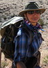
The 40 was in fine shape climbing the hill to Williams, and the only sketchy part of the drive was the last 20 miles into the park. Pockets of blue sky along the drive devolved into flurries as I packed up to get started. As the others were an hour or so behind me, I decided to get started on my own. I enlisted a local hippy to shuttle me from BA over to SK where we engaged in some shenanigans for the tourists before setting off.
Day 1 - SK to Phantom
7.47mi, 0aeg, 2:58
I set out with microspikes and a poofy as the fresh snow brought the magic of the canyon alive. The rim was socked in and drive-by tourists had no view of anything, but after dropping a couple hundred feet the canyon came into view and looked amazing. Spikes lasted until close to Hoo-hah Point which is when I was also down to short sleeves on a nice chilly day.
Below the tipoff a shower started to pelt me with graupel and I donned my skirt. A few flashes of lightning and zero-delay claps of thunder kept things spicy. Five minutes later it was nice again. Late afternoon on a snowy day made SK peaceful and deserted. I think I saw 3 groups between Hoo-hah and the ranch and took advantage with a lengthy break taking inappropriate photos for the gram. 
The others arrived after I had set up camp and sauntered up to the Cantina to enjoy a beverage.
Day 2 - Phantom to Clear Creek
9.69 miles, 2500aeg, 4:19
This was all new trail for me, and it was very enjoyable. The views from the trail down to the ranch are quickly eclipsed by the views into the inner gorge and the two bridges. The next mile traverses just below the supai in one of the great stretches of trail in the park. We endured the countless little ups and downs that add up and as we approached camp the cloudy skies began to mist a little bit. We set up camp and the nuisance mist had us all in our tents once dinner was over.
Day 3 - Clear Creek to the Colorado
13.34mi, 1500aeg, 6:32
Wednesday's storm dropped a foot of snow on the North Rim, but there was no runoff of note in any of the drainages we had seen thusfar so I assumed that Cheyava would not be flowing and decided instead to make the trip to the river. It's a long river spur, but a mostly pleasant creek to walk along. I managed to keep my feet dry with about 50 deliberate landing-spot calculations on crossings.
There's a waterfall about 3/4mi from the river that has a dicey bypass. I didn't know if I'd be able to do this one and upon arriving there I was skeptical at first. As I was by myself on this daytrip, I had a higher threshold for poor decision making, and still convinced myself that I could not only get down, but also get back up on the return. Phew!
Reaching where Clear Creek hits the Colorado, there's no "delta" or anywhere to hang out. Just a canyon straight into the river. I was able to find routes both upstream and downstream of the confluence that lead to small beaches. This is the first time I've stood on the banks of the river comfortably wearing a poofy, beenie, and gloves -- and that might not happen again!
The trip back up creek was uneventful. After getting up the waterfall climb I was able to relax and motor back to camp where the others had just recently returned from their dayhikes.
Day 4 - Clear Creek to Phantom
9.91mi, 1000aeg, 3:43
Saturday we reversed course and headed back to Phantom. It was another cloudy cool day with no rain. Some snow showers were visible near the rims, but the inner canyon was great. I took the time to access cell signal along the trail and check the weather update. We knew Sunday was supposed to be stormy with a lower snow level for the hike out. The updated forecast confirmed the previous and we planned for a suckfest hike out.
Day 4 - River Trail Loop
2.34mi, 300aeg, 1:03
First we set up camp preparing for the rain. We checked for a cancellation thinking a rainy night might be more pleasant in a cabin, but none was available. There was plenty of daylight so we took an hour to loop the River Trail crossing the two bridges. This is a great little hike out of camp if you're ever staying at Phantom.
Ranger Della stopped by camp near sunset to invite us to the scorpion drop at the ranger station. Phantom celebrates at backpackers bedtime, so somewhere around 8:04pm the scorpion was lowered down the flagpole and 50 or so folks enjoyed the festivities over hot beverages and maybe a flask or 3. A few of the folks there are recognizable names to people who frequent this place. We had a blast and polished off whatever treats were being served before settling in prepared for packing up and hiking out in the rain tomorrow.
Day 5 - Phantom to BA
10.45mi, 4,668aeg, 4:35
We were all up shortly after first light ... earlier than previous days, but we all realized the rain had not arrived and figured we should get started as soon as we could. The others had parked near SK and headed back up that way. I had never hiked BA before (  ) so I opted for the longer walk, also, mostly because that's where I parked! ) so I opted for the longer walk, also, mostly because that's where I parked!
There was a spritz of rain climbing out of Pipe Creek but otherwise it was a surprisingly pleasant hike out -- until the 3-mile resthouse. It rained and it rained hard. It was actually quite enjoyable knowing I only had to endure an hour of it rather than the 5 hours I had prepared for! Several wet rats jealously made fun of my skirt and umbrella. I laughed.
The rain had turned to snow by the lower tunnel, and spikes were required a few steps later, with several inches of new snow by the time I got to the top. It was pretty much a blizzard at this point, so I got into my truck and changed out of my hiking clothes before snowshoeing over to El Tovar for a bowl of chili at the bar.
The snowfall was intense and it made the drive home entertaining. The 40 was closed so headed to Flag to risk whatever the 17 would provide. It took 3 hours to get there, so I invited myself to stop at a friends house where I napped for a couple hours before heading down the hill around 11pm after the cluster of snow traffic was long gone and I saw only 5 other cars and a plow in the first 30 miles.
Nothin like a little winter to spice up a good backpacking trip! I might have to make this a thing. |
| _____________________
| I'm not sure what my spirit animal is, but I'm confident it has rabies. |
| | |
|
|
|
 Route Editor