username
X
password
register
for free!
help
ArticlesGuidesRoutes
 
Photosets
 
 Comments
triplogs   photosets   labels comments more
Two Spot Trail - 10 members in 14 triplogs have rated this an average 3.1 ( 1 to 5 best )
14 triplogs
login for filter options
May 12 2024
avatar

 Routes 2
 Photos 50
 Triplogs 4

36 female
 Joined Jun 24 2020
 Munds Park, AZ
Gold Digger TrailFlagstaff, AZ
Flagstaff, AZ
Hiking avatar May 12 2024
hpiet19Triplogs 4
Hiking5.68 Miles 584 AEG
Hiking5.68 Miles   2 Hrs   20 Mns   2.43 mph
584 ft AEG
 no routes
1st trip
Linked   linked  
Partners partners
OllieDood
Nice trail. Didn’t see many flowers but a lot of ponderosa pines and some oak trees. Heard a band-tailed pigeon and saw what looked like a falcon. I thought we would see more hikers or mountain bikers for a Sunday afternoon mid-May. We only saw one party with a dog. This trail is dog friendly. The views on the lake from the scenic point are great.
  1 archive
May 18 2023
avatar

 Guides 27
 Routes 518
 Photos 5,861
 Triplogs 883

72 female
 Joined Jan 21 2006
 Eagar AZ
Rogers Lake Kayaking, AZ 
Rogers Lake Kayaking, AZ
 
Kayak avatar May 18 2023
azbackpackrTriplogs 883
Kayak4.00 Miles
Kayak4.00 Miles   2 Hrs   20 Mns   2.00 mph
 
1st trip
Linked   linked  
Partners partners
Debz
Here's another lake which usually is just a damp patch or collection of puddles in the middle of a dry meadow. But right now it's a real lake! We had it to ourselves on Thursday. Judging by the appearance of the shoreline, it could actually hold more water. Maybe if we have a second really snowy winter it will fill up all the way?

I brought my folding boat, an Oru Coast XT. It's much easier to transport than my sea kayak, when I'm going with a friend.

We saw some birds: coots of course, plus mallard ducks and eared grebes, who were busy airing their grebances. The rest of us were having fun...

water 1 out of 5water 2 out of 5water 3 out of 5water 4 out of 5 Rogers Lake 76-100% full 76-100% full
_____________________
There is a point of no return unremarked at the time in most lives. Graham Greene The Comedians
A clean house is a sign of a misspent life.
  1 archive
Aug 21 2021
avatar

 Routes 7
 Photos 273
 Triplogs 234

54 male
 Joined Jul 16 2011
 Phoenix, AZ
Gold Digger TrailFlagstaff, AZ
Flagstaff, AZ
Hiking avatar Aug 21 2021
EartheistTriplogs 234
Hiking5.61 Miles 494 AEG
Hiking5.61 Miles   2 Hrs   27 Mns   2.29 mph
494 ft AEG
 no routesno photosets
1st trip
Linked   linked  
Partners none no partners
wildflower observationwildflower observationwildflower observationwildflower observationwildflower observation
Wildflowers Observation Light
_____________________
 
Aug 03 2021
avatar

 Guides 99
 Routes 1,484
 Photos 16,072
 Triplogs 1,374

male
 Joined Jan 07 2017
 Fountain Hills,
Arizona Fire Lookouts III, AZ 
Arizona Fire Lookouts III, AZ
 
Hiking avatar Aug 03 2021
DixieFlyerTriplogs 1,374
Hiking10.60 Miles 2,234 AEG
Hiking10.60 Miles
2,234 ft AEG
 
I decided to head up towards Flag and Williams and visit 4 Fire Lookouts: Woody Mountain; Turkey Butte; Summit Mountain; and Round Mountain.

Woody Mountain
I started and ended this hike at the Rogers Lake Natural Area. I too the Two Spot Trail to the Gold Digger Trail, and then took forest roads up to the summit. This was a very enjoyable hike through a nice forest.

Once on top of the mountain, I went to the Lookout Tower. The tower is 46' high with a 7X& metal cab. The first lookout on Woody Mountain was a tree stand from 1910-1921; it was replaced by a wood tower from 1922-1936, when the current tower was built. I climbed the stairs on the tower up to the trap door, which was padlocked shut.

After checking out the tower, I went NE to an obvious highpoint and located the benchmark.

Turkey Butte
After hiking Woody Mountain I drove over to Turkey Butte. Turkey Butte is just outside of the Rafael Fire closure area.

I saw several mule deer about 1/4 mile away from where I parked to go to the tower. Due to COVID, signs there prohibited going up into the tower. I walked up 2 of the 3 flights of stairs and took a few pictures before heading back down.

I enjoyed the short hike to the tower, and this is worth checking out if you happen to be in the area.

Summit Mountain
After leaving Turkey Butte, I drove to Williams and then made my way to the Summit Mountain Trail. This was a nice hike up to the summit of Summit, although the trail is a bit overgrown in places. There is an overlook at the top that has some nice views. After enjoying the views I walked about 100 yards NE of the communication towers to what I think is the highpoint of Summit Mountain.

There was never a lookout structure on Summit Mountain; instead there was a stand built in a ponderosa pine tree in 1916. At that time it was common to build a platform in a prominent tree that someone could get in and lookout for fires. In 1992 surviving trees that still had much of their lookout function were added to the National Register of Historic Places. The Summit Mountain Tree was one of these.

I had the GPS coordinates for where the lookout tree was supposed to be, but I forgot to load the waypoint on my GPS. I did not see the tree so I may have to go back out there sometime to see if I can locate it.

Views at the top were nice, and I am happy that I did the hike.

Round Mountain
I was looking forward to seeing the Round Mountain Lookout. It was originally constructed in 1934 on Saddle Mountain 8880 in the Coconino Forest, and was moved to Round Mountain in 1960. When it was moved, a side door was installed to replace the customary trap door.

After leaving Summit Mountain, I drove south on County Road 73 to FR 354, and then to FR 129 and FR 138. FR's 129 and 138 were really rocky and rutted out in places. I was on these roads for 5 miles or so, and it took me close to 30 minutes to get to FR138A, where I parked and walked up to the summit.

However, when I go to the Round Mountain summit there was no tower there. There was not even a sign that a tower was ever there. I walked around a bit and the only thing that I saw were 3 grave markers.

When I got back home I called the Williams Ranger District to fine out what happened to the tower, and was told by the Ranger answering the phone that the tower was not being used so it was taken down. She said that I was the 3rd person that had called inquiring about the tower.

Summary
I really enjoyed the Woody Mountain hike. Turkey Butte and Summit Mountain were short hikes, but I was glad that I did them. However, Round Mountain is one and done for me. It was a bit of rough ride to get there, and with the tower being dismantled, there is not much to see there.

Stats for these hikes are below. The total above is the sum of these 4.

Woody Mountain: 5.3 miles with an AEG of 984 feet
Turkey Butte: 0.8 miles with an AEG of 213 feet
Summit Mountain: 2.7 miles with an AEG of 686 feet
Round Mountain: 1.8 miles with an AEG of 351 feet
_____________________
Civilization is a nice place to visit but I wouldn't want to live there
  1 archive
Jul 07 2020
avatar

 Guides 93
 Routes 397
 Photos 4,984
 Triplogs 4,124

49 male
 Joined Jun 20 2003
 Tucson, AZ
Gold Digger TrailFlagstaff, AZ
Flagstaff, AZ
Hiking avatar Jul 07 2020
fricknaleyTriplogs 4,124
Hiking5.20 Miles 554 AEG
Hiking5.20 Miles
554 ft AEG
 no routes
1st trip
Linked   linked  
Partners none no partners
we did the gold digger/two spot loop. didn't have time to hit woody mountain. first time out here and this is a nice area. good views from the scenic overlook. would be a treat to run.

did the drive through at bearizona afterwards. the bears were really putting on a show :lol:
_____________________
hi
 
May 30 2020
avatar

 Guides 41
 Routes 1,626
 Photos 14,983
 Triplogs 2,760

69 male
 Joined Jan 20 2009
 Far NE Phoenix,
Woody Mountain, AZ 
Woody Mountain, AZ
 
Hiking avatar May 30 2020
The_EagleTriplogs 2,760
Hiking6.23 Miles 919 AEG
Hiking6.23 Miles   2 Hrs   17 Mns   2.81 mph
919 ft AEG      4 Mns Break12 LBS Pack
 
1st trip
Linked   linked  
Partners none no partners
Route Scout Route Recorded  on Route Scout | Pop | Map | Popup | MapDEX
I stopped at this one we'd done a few years ago on the way home from hike one.

All the trails to the top of woody were in great shape.

At the top of Woody, I stopped at the now camera equipped LO tower and then walked to the NE to find the other WOODY marker. Much better views over here and a great place for a short break.

The brief thunderstorm on the way down felt pretty good.
_____________________
There is a very fine line between "hobby" and "mental illness."
Dave Barry 🦅
 
Apr 25 2020
avatar

 Guides 94
 Routes 840
 Photos 22,055
 Triplogs 1,993

52 male
 Joined Sep 18 2002
 Tempe, AZ
Woody Mountain, AZ 
Woody Mountain, AZ
 
Hiking avatar Apr 25 2020
chumleyTriplogs 1,993
Hiking5.11 Miles 990 AEG
Hiking5.11 Miles   1 Hour   57 Mns   3.07 mph
990 ft AEG      17 Mns Break
 
1st trip
Linked   linked  
Partners partners
John9L
After a longer hike earlier in the day and a nap back at camp, we decided to make a run up Woody Mountain.

The combination of the two county trails are fine, but really built for mountain biking. The road hike to the summit is as nice as any fire tower road I've ever seen.

The tower was open, and the cab was still in good shape, though it is apparent that this lookout has been replaced by video surveillance. There's a benchmark under the tower, and another one only a quarter mile away. I opted for the direct route down, skipping most of the unnecessary switchbacks. There was a bit of snow on the north-facing slopes and I saw a deer on the way down before watching the sun set over Rogers.
_____________________
I'm not sure what my spirit animal is, but I'm confident it has rabies.
  1 archive
Apr 26 2019
avatar

 Guides 13
 Routes 38
 Photos 1,651
 Triplogs 577

60 male
 Joined Nov 15 2005
 Jackson, CA
Rogers Trail - Coconino NFFlagstaff, AZ
Flagstaff, AZ
Mtn Biking avatar Apr 26 2019
toddakTriplogs 577
Mtn Biking25.00 Miles 1,500 AEG
Mtn Biking25.00 Miles   5 Hrs      5.00 mph
1,500 ft AEG
 no routes
1st trip
Partners none no partners
Lovely day to mtn bike the trails in Ft Tuthill (including the Bridge and Highland trails) and out to Rogers Lake, which really is a legit lake right now after the wet winter. Trails are easy to moderate riding, often rocky but no white knuckle drops or climbs.
_____________________
 
Sep 28 2018
avatar

 Guides 116
 Routes 337
 Photos 11,399
 Triplogs 894

63 male
 Joined Dec 20 2010
 Sunnyslope, PHX
Two Spot TrailFlagstaff, AZ
Flagstaff, AZ
Hiking avatar Sep 28 2018
kingsnakeTriplogs 894
Hiking8.17 Miles 988 AEG
Hiking8.17 Miles   3 Hrs   2 Mns   2.69 mph
988 ft AEG
 no routes
1st trip
Linked   linked  
Partners none no partners
The last time I had been out to Rogers Lake was for a weekend-long Army ROTC FTX just before we were commissioned. The seniors acted as cadre, while the underclassmen were good guys and OPFOR. Unlike the previous year, when we had to EndEx before dusk for safety reasons — hypothermia, as it was low 30’s and sleeting — we went 24 hours straight, before I returned to my ghetto apartment at Franklin & Verde St. across from the old football stadium. 🏈

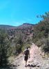
After my wife & I spent some time looking at the info displays on Rogers Lake wildlife and bird migration, life-size metal replicas of elk antlers and various critter skulls, I started walking south on Two Spot Trail.

Rogers Lake is usually dry, so I was not surprised by the lack of water. I was kind of hoping for flowers, since the lake must retain some life-giving moisture. Nada. There were tons of cattle though! 🐮

If you see some blue roofs across Rogers Lake, that is the Frontiere Ranch, which was owned by Georgia Frontiere, who finally scored when husband #6 conveniently drowned. I wonder if she's who the Gold Digger Trail is named after? 🤔

The ranch is now operated by Coconino County, though after 5+ years they still haven’t figured out what they want to do with it.

I started finding flowers along Gold Digger Trail: western yarrow, lupine and especially thistle. The thistle were deep pink-purple. Some of the prettiest thistle I’ve ever seen.

When I arrived at the fire lookout access road, I turned right towards Woody Mountain.

A few hundred yards from Gold Digger Trail, there is a gate. The vehicle gate was locked. The pedestrian gate open, with no chain. I closed it and stuck a stick where the bolt would have been.

There’s quite a bit of stuff to check out at the top of Woody Mountain — see it all in my video below! 😉 — but the highlight is obviously the fire lookout.

Woody Mountain fire lookout’s bottom section of stairs was quite wobbly. I figure because if they were solidly anchored, then the flexing of the tower in high winds would break the stairs. Even on the steadier upper sections of stairs, it was still disorienting to have that open space so close by.

Unfortunately, the observation deck was locked. Still, there were great 360° great views from the Nearly Top: A-1 Mountain, the San Francisco Peaks, Mount Elden, the U.S. Naval Observatory, Flagstaff, the airport, Mormon Mountain, etc. Not Bill Williams Mountain, though: That was obscured by smoke from the Platypus Fire controlled burn near Sycamore Canyon. (The smoke would get so bad that later in the afternoon you could not see the Peaks from downtown Flagstaff.) 🔥

Afterwards, my wife & I repaired to The Lumberyard where I had a few beers while we watched endless trains go by. (One was, no lie, 211 cars, with pusher engines not only at the end, but in the middle!) 😳

Hike Video: https://vimeo.com/495469493
Fire Lookout: https://vimeo.com/495469583
 Culture
 Culture [ checklist ]
[ checklist ]  Bridge  Cag Shot
foliage observationfoliage observationfoliage observationfoliage observationfoliage observation
Autumn Foliage Observation Isolated
Mostly near the picnic ramada.
wildflower observationwildflower observationwildflower observationwildflower observationwildflower observation
Wildflowers Observation Isolated
Still some flowers here and there. Thistle were deep pink-purple!
_____________________
http://prestonm.com : Everyone's enjoyment of the outdoors is different and should be equally honored.
  1 archive
Sep 09 2018
avatar

 Guides 21
 Routes 1,182
 Photos 36,858
 Triplogs 1,570

69 female
 Joined Feb 26 2004
 Phoenix, AZ
Gold Digger - Two Spot Trails, AZ 
Gold Digger - Two Spot Trails, AZ
 
Hiking avatar Sep 09 2018
tibberTriplogs 1,570
Hiking5.86 Miles 605 AEG
Hiking5.86 Miles   2 Hrs   57 Mns   2.39 mph
605 ft AEG      30 Mns Break
 
1st trip
Linked   linked  
Partners partners
desertgirl
We were up for AZ Trail Day at Flagstaff and since our AZT hike was canceled, I found this one. It had first peaked my interest on the ArizonaHikers Facebook site and then Joe and Bruce did it so it's my turn.

A lot of traffic on the dirt road today as there was some kind of wine event at the Arboretum but we finally made it to the TH. We geared up and crossed the road to begin our journey. It was already a little warm and the humidity was up a bit as well. Once we came to the intersection we decided to go north and do the loop clockwise. I really hadn't studied it that much but knew the elevation wasn't bad no matter which way you went. However, this is the shorter version of the up I think as the other is a steady gradual up.

Meanwhile it's a nice little steady grade here and there as you switchback your way to the top of whatever hillside we are traversing. We come to a sign that says there is a viewpoint but when I looked at RouteScout, it didn't show the route going up to it but maybe I wasn't zoomed in enough. I wasn't planning on going but Ambika wanted to see so good for her as it was probably the highlight of the trip for us as the views from the bench are pretty darn good.

Once there we fiddled around with the peakfinder app and it was a bit challenging to line up the mountains. Once I figured out the contour of Bill Williams, we were able to get it pretty close. And this weekend while I was examining it I was able to figure out the mountains and marked them on uploaded route.

From there our next destination was the aspen grove; not exactly sure if it constitutes a grove but it was nice. The area we walked thru had a little burn it looks like and there was quite a bit of lupine. We examined the ramada for a short time before heading up the hill. I assume from the road we crossed is how you would get to Woody Lookout. I think that would make a nice workout hike so plan to do it next summer in prep for Glacier Park.

We ended up walking past another marker and for some reason I decided to check out RouteScout only to discover that we should have zigged instead of zagged. I am not sure where the Rogers Trail goes but I wanted to stay on the route as we didn't want to be overly ambitious on our hike today. Once we got back on track it was downhill from here for a bit. I decided we would take a break at the four mile mark leaving us with less than a couple miles to the finish.

Once we crossed the road we headed north along the dry lake. It really is pretty as you get good views here and there toward various mountains. There's lots of bird action too and some more flora. While Rxing flora I found this great .pdf online about the area: http://www.coconino.az.gov/DocumentCent ... lan?bidId= It's quite extensive and has some interesting stuff in there. Wish all areas like this had such a plan with such wonderful information.

It had clouded up pretty good by now which was nice. When we got back to the TH we grabbed the sandwich wrap we had picked up at the Maverick station and enjoyed that while enjoying the view. Yep, it was a nice little hike but thank goodness there was some flora to keep me interested.

For the drive back I thot you could continue south and cut over to I-17 but I misread the map and Ambika suggested we turn around. You can still cut over to I-17 via FR 532 from FR 231. It looks like you could continue south and cut across on FR75 but it's a windy son-of-a-gun to 89A but then still a lot to go before you cut up to Kachina Village and back to I-17. Ours was the better route.

Working without youtube's stabilizer and am using Filmora to stabilize. I think the result is actually much better. I stabilize the video clips in Filmora and then put them into my Premiere Elements. Found a new music source too. This video has footage from our Fri night in Flagstaff, pictures from AZ Trail Day as well as the hike.
[ youtube video ]
_____________________
For me, sometimes it's just as much about the journey as the destination.
Oh, and once in awhile, don't forget to look back at the trail you've traveled.
 
Sep 09 2018
avatar

 Guides 20
 Routes 13
 Photos 3,189
 Triplogs 451

female
 Joined Mar 31 2002
 Chandler, AZ
Gold Digger - Two Spot Trails, AZ 
Gold Digger - Two Spot Trails, AZ
 
Hiking avatar Sep 09 2018
desertgirlTriplogs 451
Hiking5.86 Miles 605 AEG
Hiking5.86 Miles   2 Hrs   57 Mns   2.39 mph
605 ft AEG      30 Mns Break
 no routesno photosets
1st trip
Linked   linked  
Partners partners
tibber
_____________________
 
Jul 07 2018
avatar

 Guides 264
 Routes 2,797
 Photos 14,494
 Triplogs 5,894

55 male
 Joined Nov 20 1996
 
Gold Digger - Two Spot - Woody LO Loop, AZ 
Gold Digger - Two Spot - Woody LO Loop, AZ
 
Hiking avatar Jul 07 2018
joebartelsTriplogs 5,894
Hiking7.23 Miles 959 AEG
Hiking7.23 Miles   3 Hrs   1 Min   2.48 mph
959 ft AEG      6 Mns Break
 
1st trip
Linked   linked  
Partners partners
The_Eagle
Never gave this area west of the 89A turnoff much thought. Which is practically a suburb of Flagstaff. [ SW of Flagstaff Loop Trail :: map ]

Two Spot Trail
After a quick 0.35 miles up hang a left on Gold Digger Trail.

Scenic Lookout
Interesting 300 foot trail exactly 1 mile up Gold Digger. The lookout is scenic and a military grade bench to boot. More thought and $$ invested than remotely expected.

Aspen Grove Ramada
Odd to stumble upon this modern and well built structure. Woody Mountain road is 315 feet away but there isn't a use trail to connect and that road rarely gets used. Bruce pondered some ol' gold digger club being involved.

Woody Lookout - 1.9 mi RT
Worthy little destination once 1.5 miles up Gold Digger. Once again something isn't kosher in Coconino. Nice modern deadbolted outhouse for the lookout is vented for a burrito club. Whereas Kendrick 18 miles NNW has been stinking for a decade. The western two thirds of Kendrick is Kaibab NF, perhaps that explains.

Two Spot Trail
After an easy 2.4 miles down Gold Digger we strolled just over a mile on Two Spot. Roger's Lake was dry. Looks 4-20 feet deep is the limit of this oversized pond. Intense interpretive signs, plaques and displays at the trailhead.

Synopsis
Big pine hikes are fun. A great low key option for someone getting into hiking or interested in a forest hike. The gold diggers certainly left a mark. Someone loves(d) this area and it shows. If you hike for likes this isn't for you.
 Fauna
 Fauna [ checklist ]
[ checklist ]  Ladybug beetle
 Named place
 Named place [ checklist ]
[ checklist ]  Woody Mountain Fire Lookout

water 1 out of 5water 2 out of 5water 3 out of 5water less than max Gold Digger Tank 51-75% full 51-75% full

dry Rogers Lake Dry Dry
no water skiing unless you BYOW
_____________________
- joe
 
Jul 07 2018
avatar

 Guides 41
 Routes 1,626
 Photos 14,983
 Triplogs 2,760

69 male
 Joined Jan 20 2009
 Far NE Phoenix,
2 Spot-Gold Digger-Woody Mountain, AZ 
2 Spot-Gold Digger-Woody Mountain, AZ
 
Hiking avatar Jul 07 2018
The_EagleTriplogs 2,760
Hiking7.51 Miles 986 AEG
Hiking7.51 Miles   3 Hrs      2.59 mph
986 ft AEG      6 Mns Break12 LBS Pack
 
1st trip
Partners partners
joebartels
Not wanting to drive 320 miles RT for a 10 mile hike, I needed to find something else for a second hike to make the trip worthy.

Woody Mountain fit the bill. @Jim_h has done it off trail from the east, @azbackpackr on FR 231C from the north and @Sredfield on FR's from the west. I found and decided to try some new trails that started at Rogers Lake.

Two Spot Trail and Gold Digger Trail are well worn tracks through mixed pine and hardwood. These trails alone, would make for a great family hike, complete with a Ramada for a picnic. Part way through the Gold Digger Trail, we took the FR to the Woody Peak LO. At the top of Woody was the currently unmanned LO, a newer vault toilet, a locked building, a rustic shower and other assorted items.

We started down and it was a steady drizzle all the way to the Truck.

Highlights for me were Rogers Lake (Meadow) which is almost 2 miles across, Aspen Grove Ramada, and the Woody Mountain Lookout.
 Culture
 Culture [ checklist ]
[ checklist ]  Benchmark

water 1 out of 5water 2 out of 5water 3 out of 5water less than max Gold Digger Tank 51-75% full 51-75% full

dry Rogers Lake Dry Dry
_____________________
There is a very fine line between "hobby" and "mental illness."
Dave Barry 🦅
 
Aug 21 2016
avatar

 Guides 11
 Routes 2
 Photos 3,776
 Triplogs 334

48 male
 Joined Jun 09 2009
 Mesa, AZ
Two Spot TrailFlagstaff, AZ
Flagstaff, AZ
Mtn Biking avatar Aug 21 2016
cw50mustTriplogs 334
Mtn Biking2.50 Miles 71 AEG
Mtn Biking2.50 Miles
71 ft AEG
 
1st trip
Linked   none no linked trail guides
Partners none no partners
This was the second day of our Flagstaff weekend and we wanted to find somewhere new to us to ride the bikes. The drive out here was nice, it was cloudy all morning, and the area, at least on this day, was the opposite of crowded. The trails here are both new, and not well used so in some areas they are pretty faint, but still easy to follow. we also ran into a bunch of sheep on FR231 on our way out.
_____________________
 
average hiking speed 2.45 mph

WARNING! Hiking and outdoor related sports can be dangerous. Be responsible and prepare for the trip. Study the area you are entering and plan accordingly. Dress for the current and unexpected weather changes. Take plenty of water. Never go alone. Make an itinerary with your plan(s), route(s), destination(s) and expected return time. Give your itinerary to trusted family and/or friends.

helpcommentissue

end of page marker