|
| | | Indian Garden / Plateau Point Backpack, AZ | | | |
|
|
Indian Garden / Plateau Point Backpack, AZ
| | |
| |
|
| Backpack | 14.30 Miles |
3,900 AEG |
| | Backpack | 14.30 Miles | 2 Days | | |
| 3,900 ft AEG | | | | |
|
|
| |
| Partners |
|
none
[ show ]
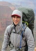
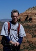
| no partners | | Took Friday off and decided to try my luck for a last-minute overnight permit at the GC with my wife and two of our kids. Our preferred location was Indian Garden. When I called the backcountry office at 8 a.m. on Friday, they said they had 4 spots left, but no guarantees they would still be there when we arrived. Regardless, it sounded like there would be other options. Arrived at the BC office at 1 pm and got the desired permit. 
We strapped on our packs and hit Bright Angel Trail about 2 pm. The forecast all week had been threatening thundershowers, so we came prepared to get wet. Turned out we never saw a drop until we driving home!
The trail was fairly crowded well past 1.5 mi. resthouse. It was hot, but not too bad, considering it's the middle of July.
Just past 1.5 mi. resthouse, I went a few hundred yards out on the "route" over to the Battleship. Hiking with family precluded me from doing the full side trip. Another time.
Shortly after getting pack on the trail, we came "face-to-butt" with a massive bighorn, who was standing in the middle of the trail, looking intently in the opposite direction and paying absolutely no attention to us as we came up from behind. He was a pretty impressive specimen. After some obligatory photos, he finally decided to let us pass.
Made it down to IG and set up camp. This was my first time camping at IG since I was a kid. Nice sites; deer all around; and amazingly clean toilets. I'm not too picky when it comes to the restroom facilities on the trail, but I was duly impressed. Kudos to the ranger staff.
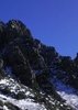
After setting up camp and having dinner, we headed out to Plateau Point for the storied views and sunset. First time out there for me. The view was as advertised. Wow! Beyond the views, I loved just listening to the roar of the river 2000 ft. below. There were a few other small groups out on the point, but--surprisingly--they all headed back before the sunset started in earnest. So, we enjoyed the awesome sunset in solitude.
It was still fairly light for most of our return trip to camp, though we donned the headlamps for the last 1/2 mile or so.
Had a little Mountain House Apple Crisp for dessert and then hit the hay for one of the worst night's camping sleep I've had. In short, it was blazing hot! Not sure why we bothered to schlep sleeping bags down there. At that point, I was more-or-less begging it to rain. We got plenty of wind, including some strong gusts, but it seemed to stay high up in the trees and didn't blow through the tent at the ground level; thus, providing little relief. I could see some flashes of lightning and a little thunder rumbling off in the distant canyon, but the threatened storm never came anywhere near. All in all, probably a good thing.
I assume everyone else in IG had the same night's sleep I did, as the camp was up and bustling with activity by 4:30 a.m. By the time we finished with our breakfast at 6 a.m., the camp was basically a ghost town.
I had my heart set on doing a little exploring before we headed out--perhaps taking the Tonto east over and down Old BA to where it intersects the current trail and looping back around to IG. But, I couldn't get any traction for the idea from the rest of the crew, so I filed that one as well in the "another time" folder, and we shouldered up our packs for the hike out.
On the plus side, our early start meant we enjoyed a fair amount of shade on the climb up. We also saw a lot of wildlife on the trip, including several deer, a rattlesnake, a frog, and about a half dozen ewes who were probably connected to the bighorn we saw the day before, going down.
Once on top, we rewarded ourselves with some ice cream and then hit the road for home. Shortly after we exited the park, we encountered the promised rain, which continued on and off through Flagstaff.
A quick trip, but very enjoyable. A nice tune up in the lead up to our Deer Creek/Thunder River trip in the fall. |
| _____________________
| | |
|
|
|
 Route Editor


 Probably the best part of the whole trip was when Margeaux and the crew threw Madi a birthday party at the river, complete with cake and singing! She loved the attention (and the cake)! What a special moment for her.