|
| | | La Barge - Battleship Overnighter, AZ | | | |
|
|
La Barge - Battleship Overnighter, AZ
| | |
| |
|
| Backpack | 15.18 Miles |
4,125 AEG |
| | Backpack | 15.18 Miles | 8 Hrs 31 Mns | | 1.93 mph |
| 4,125 ft AEG | | | | |
|
|
| |
| Partners |
|
none
[ show ]
| no partners | | Attending a friend's funeral scuttled plans for a long Saturday day hike, so we pivoted to a quick overnighter in the Supes with a mid-afternoon start.
Got on the trail from the Canyon Lake Marina around 2:30 pm. The lot there is signed as reserved for Marina slip owners, but there are 10 signed/designated spots for hikers on the south end of the lot. All 10 were full when we arrived, but we parked next to the 10, and there was plenty of parking generally. I don't recall seeing signed/designated hiker spots in my previous hikes here, so I thought I'd mention it.
Temps were in the low/mid 80s at the start. Warm, but a slight breeze kept things tolerable on the initial climb. There are two routes to the top of the initial hill. A fair amount of work has been put in to obscure/discourage use of the more direct route, though I'm not sure why.
Just past the first hill, we ran into a returning day hiker who asked where we planned to camp. When we mentioned La Barge Box, he said he was there earlier in the day and two guys were already occupying the main site next to the big pool. I was a little bummed but figured, we could manage another option.
Our day hiker also convinced us it was better to take the longer route to La Barge Box around the Battleship, rather than taking the shorter bushwhack up La Barge Creek. I've done that bushwhack before, but not with a backpack, and not with the creek running.
As we hiked and the sun went down, it lit up the westward facing cliffs and mountains with amazing colors. The abundant water provided many "reflection" photo opportunities.
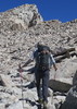
Going over the Battleship saddle is a route/adventure. A fairly developed route has developed, but it took us a little poking around to find it on the climb up.
Arriving at La Barge box, we met and talked briefly with the two guys at the main site. The large pool was full--definitely good for a swim, if desired. The two guys offered to share the site, but we opted to continue around the corner and camp on the slick rock. Not normally something I would do or recommend in this area, if there were any chance of rain. As it was, it turned out to be an excellent spot--elevated a bit above the running creek, relatively flat, and surrounded by nice pools and amazing views of the Box.
The night was a sliver moon, so tons of star-gazing opportunities. A couple of nearby owls were also hooting it up.
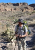
In the morning, we packed up camp and retraced our steps. At the saddle, we decided to add on a trip out to the Battleship summit. It was my wife's first time. I've been several times, but each time, it's a fun puzzle to solve. On this trip, it took us a few tries to find the right route that circumnavigates around to the final summit approach, but we eventually made it--and enjoyed complete solitude.
As always, the return trip along the spine was a breeze by comparison.
The rest of the hike out was uneventful. Didn't see anyone until we got close to the TH. It was a little warm on the climb up from La Barge creek, but not bad.
An excellent overnighter. Right now is prime season for backpacking in the Supes with plentiful water everywhere! |
| _____________________
| | |
|
|
|
 Route Editor


 because I can apparently never settle for easy (or easier). I knew to expect water in the creeks since I had just seen Boulder earlier in the week. While trying to determine who I might be able to lure out to join me, I figured I might give Wally a try. Sure enough, he seemed up for it, if perhaps slightly disappointed in the route mileage...so I offered up the suggestion of summiting battleship to add mileage and AEG - we left it on the table as a possibility to be explored when we got to the saddle.
 and plenty of wolfberries for snacking upon, should you enjoy such things.