|
| | | Grandview to South Kaibab, AZ | | | |
|
|
Grandview to South Kaibab, AZ
| | |
| |
|
| Hiking | 29.73 Miles |
5,367 AEG |
| | Hiking | 29.73 Miles | 16 Hrs 21 Mns | | 2.12 mph |
| 5,367 ft AEG | 2 Hrs 21 Mns Break | | | |
|
|
| |
| Partners |
|
none
[ show ]
| no partners | | Middle of last week, we looked at the calendar and considered our options on a free weekend. I've wanted to tackle the section of the Tonto between Grandview and South Kaibab for some time, and we just decided to go for it.
Hotels were pricey on the rim and in Tusayan (end of spring break?), but there was vacancy at the motel in Valle at half the price, so we decided to give that a try.
Drove up Friday afternoon and arrived around 8:30 pm. Checked in. Rooms are old but have been nicely remodeled. Very basic, but clean and neat. Have to ask for ice--they get it for you from the restaurant. We didn't try the restaurant.
We hit the hay by 9 pm, as we had a 2:30 am wake up planned. Slept pretty good, actually.
We were on the road to the TH at 3 am. Set up a shuttle at SK (locked up an e-bike there), and then drove over to Grandview TH. A pretty full moon was setting on the western horizon at just shy of 4 am, when we hit the trail.
Temps were pretty nice for March, with a little breeze, but we anticipated heat later on--as temps were hovering about 25 degrees above normal for this time of year. We each carried around 6 liters of water to start.
Headed down Grandview by headlamp. I've done that trail a handful of times now. No significant navigational challenges, and the trail is in decent shape compared to other trails that get little or no maintenance.
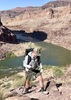
Hit Horseshoe Mesa just as it started getting light. Morning light on the eastern and northern facing walls of the canyon was magical (as always). Paid our respects to the miner's cabin, and saw a couple of red headlights out in the camping area--no doubt, a couple of campers getting up to enjoy the sunrise.
Dropped off Mesa using the trail on the western spur (rather than the more direct approach to Cottonwood Creek). We thought about heading down towards Page Spring to tag the full section of the Tonto around the Mesa, but we knew our itinerary was already pretty ambitious for a day hike, so this option allowed us to split the difference.
From that point to SK/Tipoff was all new tread for me.
No water at the point where Tonto intersects Cottonwood Creek, but clearly there was water available if you explored up or down from there. We didn't stop for water.
We stopped briefly at the obvious cairn, denoting the turn off to the Old Grandview access to the river. There was a short debate about whether to add this on (2+ miles), but I put the kaybosch on it, as we were pushing time/energy limits as it was. That said, I made a mental note to come back and do this as a Rim-to-River out and back from Grandview.
Next up: Grapevine, which is the quintessence of the Tonto--4 miles of meandering side drainage to cover less than a 1/2 mile of downriver distance. IMO, the most scenic of the drainages crossed in this section of the Tonto. Water available at both the Grapevine/Tonto crossing as well as at the marked spring on the eastern drainage, where we filtered a couple of liters.
Stopped for lunch at about the 1/2 way point at a nice overlook up river from a perch above the western arm of Grapevine. By that time, temps were in the low 90s. Luckily, a thin layer of cloud cover, and relatively consistent breeze kept things tolerable.
Rounding into Boulder Creek, we came across an abandoned backpack and trekking poles. We thought: this is not a good sign. We hollered out to see if its owner was nearby; no reply. We took a photo and wondered if we'd be making a report to the NPS later in the day. Fortunately, another 1/2 mile further on, its owner appeared--a young guy travelling in his van had camped near Boulder and decided to explore down the drainage a bit without his backpack. Not sure he had a permit (otherwise, this would not be the most scenic or water-friendly place to spend the night). He was the first human we had crossed paths with in 15+ miles.
Swinging next into Lone Tree, we met a group of retirees from Flagstaff who were doing our same hike in reverse, but over 4 or 5 days. They had spent night one in Cremation, and were leisurely spending night 2 at Lone Tree. Water was available at Lone Tree, and we once again filtered a few liters and chatted with the group for a bit about Canyon and other adventures. They were impressed (or was it, appalled?) at the ambitiousness of our one-day agenda. With another 5+ miles to go before the Tipoff, we cut off the convo and once again hit the trail.
At Cremation, we contemplated the fates of Paul Stryker and Margaret Bradley--both of whom lost their lives in this area after underestimating the unforgiving conditions of the Canyon....
After crossing Cremation, the Tonto turns very UN-Tonto-like--with two steep ups and downs, as we crossed side drainages into Cremation, followed by a what seemed to be an interminable climb up and around (FINALLY) to the Tipoff.
At that point, the sun was getting low, and after a brief bathroom break, we started the inevitable climb out.
We made quick work of the switchbacks up to Skeleton Point, but my wife's IT band began screaming at her at that point. We wrapped an ace bandage around it, took some ibuprofen, and she soldiered on. Stopping made it worse, so the order of the evening was non-stop forward movement. We donned headlamps just below Cedar Ridge, and she kept a solid pace, and we passed several struggling hikers from there to the top.
Above Cedar Ridge, the wind picked up substantially, with some serious gusts mixed in. In addition to focusing on not getting blown off the trail, we ate/inhaled a lot of swirling dust. But, at least, it wasn't hot anymore!
At Ooh Ahh Point, I knew we were about a mile from the top, which was encouraging. We continued to pass hikers and topped out a little before 9 pm. Our other friend--a strong hiker--hit the wall himself with a mile or so to go, but slogged it out and arrived just a few minutes after we did.
At that point, I hopped on the e-bike and made my way over to Grandview to retrieve our car. With the wind, it was a bit chilly but I donned my jacket and my wife thankfuly reminded me to put on my gloves!
I was back 35-40 min. later and we were finally on our way back to civilization.
Stopped in Tusayan and grabbed some dinner at the Restaurant next to Wendy's (don't recommend). Even though the food wasn't great, it was nice to get some non-trail-food calories. Afterwards, we made our way back to the motel in Valle for hot showers--and then crashed!
Sunday morning, we drove back to the Valley--another Canyon adventure in the books!
Overall, I'm glad to have done this section of the Tonto, but it's probably a one-and-done. It's the Grand Canyon, so there is a baseline level of amazing, but compared to other areas in the Canyon, I'd rank this section down the list.
The only significant section of Tonto left on my to-do list now is the Jewels area. A future backpack trip .... |
| _____________________
| | |
|
|
|
 Route Editor