username
X
password
register
for free!
help
ArticlesGuidesRoutes
 
Photosets
 
 Comments
triplogs   photosets   labels comments more
Pipeline Trail #42 - Flagstaff - 10 members in 14 triplogs have rated this an average 1.9 ( 1 to 5 best )
14 triplogs
login for filter options
Jul 10 2025
avatar

 Guides 93
 Routes 397
 Photos 4,984
 Triplogs 4,124

49 male
 Joined Jun 20 2003
 Tucson, AZ
Elden Loop from Schultz Creek, AZ 
Elden Loop from Schultz Creek, AZ
 
Run/Jog avatar Jul 10 2025
fricknaleyTriplogs 4,124
Run/Jog20.80 Miles 2,674 AEG
Run/Jog20.80 Miles   5 Hrs   13 Mns   4.26 mph
2,674 ft AEG      20 Mns Break8 LBS Pack
 no routes
1st trip
Big Loop around Mt Elden using various trails. This is a great route. It was hot but I had a water stash at mile 15 which was a life saver. Felt surprisingly good :y:
_____________________
hi
 
Sep 07 2022
avatar

 Guides 69
 Routes 37
 Photos 3,010
 Triplogs 2,387

55 male
 Joined Oct 24 2010
 Phoenix,Az
Pipeline Trail #42 - FlagstaffFlagstaff, AZ
Flagstaff, AZ
Hiking avatar Sep 07 2022
mt98dewTriplogs 2,387
Hiking11.70 Miles 158 AEG
Hiking11.70 Miles   4 Hrs   30 Mns   2.60 mph
158 ft AEG
 no routesno photosets
1st trip
Linked   none no linked trail guides
Partners none no partners
First full day of a Flagstaff vacay. I was up here a few months ago and had done some “gridding” in the Elden Environmental area. Today got to the Elden TH just before 5:30am. (Actually heard the police altercation as I was getting out of the car). Initial thought of the day was to do a trail description for the Lower Oldham trail, which is surprisingly not in HAZ. Took a roundabout route up to where the Elden trail connects to the Lower Oldham/Pipeline trail. It took me about .7 miles to reach this juncture. The Lower Oldham/Pipeline share the same trail initially. A solid single track that heads off to the west. It dances nicely through the boulders and trees losing most of its elevation in the first mile. About a mile in the trail split with a sign indicating that the Pipeline trail descended. An unnamed (assumably Lower Oldham) continued on at the current elevation. Not sure why they don’t name the trail at this juncture. Continued on this single track as it weaves along the lower slopes of Elden. When I reached the Elden Environmental area I got my first signed confirmation that I was still on Lower Oldham. As I continued west the number of user trails that interacted with Oldham began to increase. Most of them were obvious user trails, but a little after the 2 mile mark (of being on this trail) I took a wrong turn. Eventually ended up on Pipeline and took that to where it intersected the trail that came out Buffalo Park. The Lower Oldham was signed at this juncture as well and I could see it climbing above the Pipeline trail. This was my turn around point.

On the way back I followed the Pipeline trail back. Initially, coming from the Buffalo Park direction, the Pipeline is an exposed dual track. At first, though exposed, the trail is surrounded by trees on both sides, but as the trail goes east homes become a common theme on the south side. I was surprised at how much the Pipeline bounced between a dual track and single track. Guessing here. I would say it was it switched from a dual to a single track to a dual back to a single in about .8 miles increments. It was pretty much split 50-50. As I headed back east I started “gridding” the user trails that interacted with the Pipeline. Didn’t do all of them, but I got over half of them done. Most of them were less than .25 miles in length, but some “spider-webbed” quite a bit and might of added a close to a mile for that side trip.

Weather was great. Little windy early on, but that didn’t last long. Wildlife was extensive though nothing spectacular. Saw my first skunk while hiking, along with squirrels, chipmunks, lizards and a multitude of birds. Stellar blues were out in force! Flowers had a nice showing as well; yellows especially, but whites, purple and red were represented as well.
_____________________
 
Jan 15 2021
avatar

 Guides 7
 Routes 187
 Photos 2,318
 Triplogs 909

74 male
 Joined Dec 10 2016
 Gold Canyon
Pipeline Trail #42 - FlagstaffFlagstaff, AZ
Flagstaff, AZ
Hiking avatar Jan 15 2021
DaytripperTriplogs 909
Hiking5.42 Miles 617 AEG
Hiking5.42 Miles   2 Hrs      2.83 mph
617 ft AEG      5 Mns Break
 no routes
1st trip
Partners none no partners
Family trip to Flagstaff, rented an Airbnb near the Elden Lookout TH. Decided to get some exercise so we went to Buffalo Park where the dogs could roam. They drove back and I decided to hike it back to the Elden Lookout Trailhead. A few cross country runners out in Buffalo Park but not that busy despite being in the 50’s there was a strong steady cold breeze and some stronger gusts. Started along the AZT and Oldham trail then on to the pipeline trail. Initially mostly a road walk going past neighborhood use trails, a thinned out pine forest with tiny patches of snow along the way , a few people out walking their dogs from the neighborhoods. Further along after bending from south to easterly the trail became more interesting , the forest thickened , the trail became more of a one track and a bit rockier. Not sure I was on the true pipeline trail when coming across the old Elden homesite , grave and spring,info kiosks were present. Further along I was entertained by a Lindsey Stirling imitator perched on a rock ,a ways off trail , playing Celtic music on her violin :D Added some extra mileage with a wrong turn , made obvious by fences and no trespassing signs. Completed the hike on the Fatmans Loop to the parking lot where the trail became more crowded with families and runners.

dry Elden Spring Dry Dry
_____________________
Navy31 Army13
 
Apr 01 2017
avatar

 Guides 3
 Routes 202
 Photos 3,513
 Triplogs 530

male
 Joined Jan 24 2016
 Arizona
Elder CanyonFlagstaff, AZ
Flagstaff, AZ
Hike & Climb avatar Apr 01 2017
MountainMattTriplogs 530
Hike & Climb1.89 Miles 354 AEG
Hike & Climb1.89 Miles      54 Mns   2.22 mph
354 ft AEG20 LBS Pack
 
1st trip
Partners none no partners
Just got into town and needed to stretch my legs after the drive so I went to an old high school favorite.
Wether it be after school, during lunch or the occasional ditch day The Mount Elden boulders is where we would all congregate and chill 8)

I distinctly remember a time when my buddy and I scrambled up to the base of "Devils Chair" and passed by this drainage on the way, after noticing it we went back with my dog and a few others and ended up going straight down the drainage from its head until our sketchy slickrock descent came to an abrupt halt at the 100ft dryfall aka the main rappel.

With all that in mind I was hoping to possibly catch the drainage with some flow since the top of Elden still had a healthy amount of fresh snow but it unfortunately was just a trickle.

Certainly fun to reminisce and hit up the old stomping grounds!
 Named place
 Named place [ checklist ]
[ checklist ]  Elden Spring

water 1 out of 5water 2 out of 5water 3 out of 5water less than max Elden Spring Gallon per minute Gallon per minute
Healthy flow in the spring box gently flowing down into the creek bed for 25 yards or so.
_____________________
  1 archive
Jun 08 2014
avatar

 Guides 2
 Photos 1,691
 Triplogs 212

45 male
 Joined Aug 05 2004
 Peoria, AZ
Elden Lookout Trail #4Flagstaff, AZ
Flagstaff, AZ
Hiking avatar Jun 08 2014
desert_boonieTriplogs 212
Hiking6.70 Miles 2,400 AEG
Hiking6.70 Miles   6 Hrs      1.34 mph
2,400 ft AEG   1 Hour    Break
 no routes
1st trip
Linked   linked  
Partners partners
Ragnarok
Elden is a mountain I've seen a thousand times or so with each trip to Flagstaff, but for whatever reason it has never been a high on the interest list for me, mainly because of its proximity to the road. But I finally thought I would head on up and check it out, getting out of the heat for a day made it worth while and I also decided that once I was on top, I would come down the technical drainage instead of the trail.

I got Mike to come on up with me, at first I had the idea of not telling him about the descent until we would start heading down, but if I had done that he probably would have never come up with me in the first place. So up we went on the trail, running into a few people along the way, a lot of dogs on the trail as well, most of them friendly.

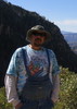
Once we got to the top, the views were pretty clear and surprisingly good of the city from an angle I haven't seen before. While getting swarmed with every bug outside for the day on top, I took a minute to toast my summit brew to John Scott. A person I never got the chance to meet in person, but definitely someone I had much respect for as he was an inspiration to me for his outdoor activities. I only hope I can accomplish a portion of what he was able to do.

After enjoying our time on top it was off to the descent. The drop in is steep on top with plenty of downed logs to negotiate in the middle of the drainage. It didn't take long to spot some movement down below, it was five deer or so wondering what the heck the two of us were doing. After a minute of enjoying them, they were off and so were we. It didn't take long to drop down the first 500ft and get into the best part of the day. The rocky scramble to the 100ft drop. The rock is steep and slick and offers a few good down climbs with some small stagnant pools to get around. Once we reached the dramatic drop we noticed three different bolt placements around the top. One was too far back, another had a terrible vector angle for the rope pull, and the last one seemed to be a perfect fit above the drop. There was some webbing here, but faded and stiff on one side so we replaced it to have a fresh anchor. This rappel is fantastic, down the top rock slope and then a good forty feet of free hang down to the bottom. The view of the rock in this area is amazing and just added to the day. Once I was down, Mike followed and he approved of the rappel as well.

From here we scrambled on down to the base of Elden and found the pipeline trail and hiked on back to the Jeep diverting from the trail the last third of a mile to make a direct line and save ourselves the horrible fact of hiking an extra quarter mile. :) A stop on Beaver Street for a fresh brew before we headed home made the day.
_____________________
"Never Satisfied"
 
May 28 2014
avatar

 Guides 14
 Routes 115
 Photos 4,830
 Triplogs 3,536

male
 Joined Oct 29 2005
 Scottsdale, AZ
Family Camp-out at Mt Eldon, AZ 
Family Camp-out at Mt Eldon, AZ
 
Car Camping avatar May 28 2014
topohikerTriplogs 3,536
Car Camping6.30 Miles
Car Camping6.30 Miles3 Days         
 no routes
1st trip
We did a family campout on the west side of MT Elden. As we drove into Flagstaff, the sky was dark with smoke from the Slide Rock fire. The smoke did clear out that night. We did a couple of hikes that included parts of Christmas Tree, Fatman’s loop, Mt. Eldon trail , Pipeline and meanderings along fence lines.
Nate originally wanted to hike to the lookout tower, but he changed his mind once we got to the Pipeline trail. We saw about 4 deer’s.
_____________________
"Everywhere is walking distance...If you have the time"
-Stephen Wright
 
Jul 05 2012
avatar

 Guides 14
 Routes 115
 Photos 4,830
 Triplogs 3,536

male
 Joined Oct 29 2005
 Scottsdale, AZ
Elden Lookout Trail #4Flagstaff, AZ
Flagstaff, AZ
Hiking avatar Jul 05 2012
topohikerTriplogs 3,536
Hiking33.32 Miles 5,428 AEG
Hiking33.32 Miles   10 Hrs   15 Mns   3.60 mph
5,428 ft AEG   1 Hour    Break
 no routesno photosets
Did a loop hike at MT. Eldon. I started at the Mt. Eldon TH and headed to the peak. I saw a forest crew doing trail maintenance on the Sunset trail. The wind was pretty cold on top, so I took the first route down, the Upper Oldham trail. The Upper Oldham is a nice single track trail. I then took the Brookbank trail. The plan was to take the Brookbank to the Sunset, to the Schultz TH. Somewhere in the Dry Lake area, there's a bunch of un-signed intersections and I took a wrong turn and wound up on the Schultz loop trail. No big deal.

Then I hiked to the Schultz TH and saw that the Little Eldon trail and Eldon Spring road are open. I went to hike the Waterline TH, but that's closed due to flood repair. So now I did plan B, the AZT # 34. I went in for about 4+ miles. About 3+ miles in, then AZT splits. I returned to the Schultz / Sunset TH(s) and had lunch. Then I took the Schultz trail to the Rocky Ridge, to the Oldham, to the Pipeline, back to the TH.

Along the way I saw the AZT connector(on the Schultz trail) from AZT 34 section. This new connector lets you cut-off about three miles by skipping the Schultz / Sunset THs. On the Pipeline trail, I explored Eldon gravesite / homestead area.
_____________________
"Everywhere is walking distance...If you have the time"
-Stephen Wright
 
Oct 30 2011
avatar

 Guides 27
 Routes 518
 Photos 5,861
 Triplogs 883

72 female
 Joined Jan 21 2006
 Eagar AZ
Pipeline Trail #42 - FlagstaffFlagstaff, AZ
Flagstaff, AZ
Hiking avatar Oct 30 2011
azbackpackrTriplogs 883
Hiking12.90 Miles 1,800 AEG
Hiking12.90 Miles   5 Hrs   48 Mns   2.69 mph
1,800 ft AEG   1 Hour    Break
 no routes
1st trip
Linked   linked  
Partners none no partners
I left a car at Buffalo Park and had a friend drop me off at Elden TH. Hiked Pipeline to Lower Oldham. Then on around to the Brookbank Trail, which took me way up to the top of the Dry Lake Hills to the dry lake, where I turned around. Then on back to Buffalo Park.

Nice day for a hike!
foliage observationfoliage observationfoliage observationfoliage observationfoliage observation
Autumn Foliage Observation Light
_____________________
There is a point of no return unremarked at the time in most lives. Graham Greene The Comedians
A clean house is a sign of a misspent life.
 
Sep 19 2011
avatar

 Guides 14
 Routes 115
 Photos 4,830
 Triplogs 3,536

male
 Joined Oct 29 2005
 Scottsdale, AZ
Elden Lookout Trail #4Flagstaff, AZ
Flagstaff, AZ
Hiking avatar Sep 19 2011
topohikerTriplogs 3,536
Hiking30.61 Miles 5,401 AEG
Hiking30.61 Miles   10 Hrs   10 Mns   3.37 mph
5,401 ft AEG   1 Hour   5 Mns Break29 LBS Pack
 no routesno photosets
I hiked over Mt. Eldon, and then returned around the base.

I parked at the Mt. Eldon TH and took the Elden Lookout trail to peak. Then I hiked the Brookbank trail,then to an un-named trail that's on my paper map(but not on the TH maps). This trail went to an un-named water tank. There's a couple of old jeep/ single track trail in this area. I followed the main trail that dropped elevation. The trail was rough in some spots with downed trees, but it looked like the mountain bikers still use it. The trail dropped into the Schultz's Creek trail. I took the Schultz Creek to the Schultz's Pass TH. The forest service posted that FFR420 (pass the TH), FR 556 and the waterline trail are closed till April 2013. I went down the new section of the AZT a bit and had lunch.

I started heading back. I took the Schultz's creek to the Sunset TH and did the Schultz's loop back to the Schultz's creek. I then took the Rocky Ridge to Easy Oldham and went to Buffalo Park. I returned and took the pipeline back to the Jeep.

This was my first time on most of these trails. The spur trails can cause some confusion. Twice I got on a spur trail and had to backtrack.

The weather was great. I felt like I was back in the mid-west on a fall day. One minute it was hot then it was chilly. It depended on the wind and the clouds.
_____________________
"Everywhere is walking distance...If you have the time"
-Stephen Wright
 
Sep 17 2011
avatar

 Guides 13
 Routes 38
 Photos 1,651
 Triplogs 577

60 male
 Joined Nov 15 2005
 Jackson, CA
Elden Lookout Trail #4Flagstaff, AZ
Flagstaff, AZ
Hiking avatar Sep 17 2011
toddakTriplogs 577
Hiking31.00 Miles 6,000 AEG
Hiking31.00 Miles   14 Hrs      2.21 mph
6,000 ft AEG
 no routes
More wandering, up and then north past Schultz Tank and on up to Doyle Saddle before heading back.
_____________________
 
May 31 2009
avatar

 Guides 73
 Routes 176
 Photos 10,174
 Triplogs 2,324

46 male
 Joined Sep 08 2006
 
Pipeline Trail #42 - FlagstaffFlagstaff, AZ
Flagstaff, AZ
Hiking avatar May 31 2009
JimTriplogs 2,324
Hiking7.80 Miles 400 AEG
Hiking7.80 Miles   2 Hrs   50 Mns   2.75 mph
400 ft AEG
 no routesno photosets
1st trip
Linked   none no linked trail guides
Partners none no partners
Fast building storm clouds prompted me to do an easy low country hike. I took the pipeline trail to the Lower Oldham trail and continued on to the start of the Brookbank trail on FR 557. We got a little wet, but it never really rained. There was some exciting lightning from a storm to the east, but it too blew away. Everything is super wet in the woods around Elden following last nights deluge.
_____________________
🍭
  1 archive
Feb 23 2007
avatar

 Triplogs 27

female
 Joined Dec 19 2006
 Tucson, AZ
Pipeline Trail #42 - FlagstaffFlagstaff, AZ
Flagstaff, AZ
Hiking avatar Feb 23 2007
shine88Triplogs 27
Hiking2.80 Miles 100 AEG
Hiking2.80 Miles
100 ft AEG
 no routesno photosets
1st trip
Linked   none no linked trail guides
Partners none no partners
_____________________
 
Jan 21 2007
avatar

 Guides 6
 Routes 6
 Photos 1,634
 Triplogs 186

58 male
 Joined Apr 04 2002
 Flagstaff, AZ
Pipeline Trail #42 - FlagstaffFlagstaff, AZ
Flagstaff, AZ
Hiking avatar Jan 21 2007
squatpukeTriplogs 186
Hiking2.80 Miles 100 AEG
Hiking2.80 Miles   3 Hrs      0.93 mph
100 ft AEG
 no routesno photosets
1st trip
Linked   none no linked trail guides
Partners none no partners
.
.
Did this hike with my wife w/about a foot of snow in most places. Started at Fat Man's Loop and ended at Buffalo where a friend picked us up. Nice day. COLD Wind.
_____________________
squatpuke@gmail.com
 
Mar 16 2004
avatar

 Routes 1
 Triplogs 15

60 male
 Joined May 20 2003
 Flagstaff, AZ
Pipeline Trail #42 - FlagstaffFlagstaff, AZ
Flagstaff, AZ
Hiking avatar Mar 16 2004
Flag_Mtn_HkrsTriplogs 15
Hiking2.80 Miles 100 AEG
Hiking2.80 Miles   1 Hour   10 Mns   2.40 mph
100 ft AEG
 no routesno photosets
1st trip
Linked   none no linked trail guides
Partners none no partners
_____________________
 
average hiking speed 2.22 mph

WARNING! Hiking and outdoor related sports can be dangerous. Be responsible and prepare for the trip. Study the area you are entering and plan accordingly. Dress for the current and unexpected weather changes. Take plenty of water. Never go alone. Make an itinerary with your plan(s), route(s), destination(s) and expected return time. Give your itinerary to trusted family and/or friends.

helpcommentissue

end of page marker