username
X
password
register
for free!
help
ArticlesGuidesRoutes
 
Photosets
 
 Comments
triplogs   photosets   labels comments more
Fay Canyon Trail #53 - 34 members in 82 triplogs have rated this an average 3.7 ( 1 to 5 best )
1, 2, 3, 4, 5  Next
82 triplogs
login for filter options
Oct 21 2024
avatar

 Routes 85
 Photos 3,718
 Triplogs 486

female
 Joined Oct 15 2002
 Rimrock, Arizona
Fay Canyon Trail #53Sedona, AZ
Sedona, AZ
Hiking avatar Oct 21 2024
cactuscatTriplogs 486
Hiking3.59 Miles 728 AEG
Hiking3.59 Miles   3 Hrs   16 Mns   1.92 mph
728 ft AEG   1 Hour   24 Mns Break
 
1st trip
Linked   none no linked trail guides
Partners none no partners
Route Scout Route Recorded  on Route Scout | Pop | Map | Popup | MapDEX
Beautiful day for a Sedona hike!
I drove past the hordes of cars lining the road at Boynton, hoping it wouldn't be such a mob scene at the Fay Canyon trailhead ... luckily, it was not. Parking area was busy, but not quite full.
The trail is easy and pretty, as advertised. It's so soft and sandy that I seriously contemplated going barefoot a few times.
Took the turn-off to the arch, and made my way up. There was one couple when I arrived, but they soon left and I had it to myself for my 15 minute stay ... I didn't encounter anyone else heading up as I descended, either.
Made my way to the end of the trail, then continued up the right fork. I really enjoy the exploration and solitude up there. I did not find the ruins - I'll have to go back with better intel- but I did see some cool stuff.
Didn't see any people until back at the end of the trail, and not too many on the return trip from there. Only about ten vehicles in the lot when I finished just after three pm.
_____________________
  1 archive
Jun 08 2024
avatar

 Routes 255
 Photos 8
 Triplogs 261

54 male
 Joined Feb 19 2015
 Phoenix
Fay Canyon Trail #53Sedona, AZ
Sedona, AZ
Hiking avatar Jun 08 2024
bjonsonTriplogs 261
Hiking3.99 Miles 400 AEG
Hiking3.99 Miles   1 Hour   16 Mns   3.19 mph
400 ft AEG      1 Min Break
 
no photosets
1st trip
Linked   none no linked trail guides
Partners none no partners
Route Scout Route Recorded  on Route Scout | Pop | Map | Popup | MapDEX
_____________________
 
Dec 29 2023
avatar

 Routes 7
 Photos 240
 Triplogs 19

male
 Joined Nov 24 2023
 Tempe, AZ
Boynton Canyon Trail #47Sedona, AZ
Sedona, AZ
Hiking avatar Dec 29 2023
overthehillsfarawaTriplogs 19
Hiking22.40 Miles 3,590 AEG
Hiking22.40 Miles   6 Hrs   42 Mns   3.34 mph
3,590 ft AEG15 LBS Pack
 no routes
1st trip
Partners none no partners
Drove up from Tempe at 4am on 3 hours of sleep with plans for a big day. Wound up doing Boynton, Fay, and Long Canyons all in one day before driving back home. Combined triplog here.

Boynton - full trail plus Subway - 7.89mi, 1296ft AEG, 2:10 elapsed
Reached Boynton trailhead at 7am about 30 min before sunrise. There were around a dozen cars there already, the lot about half full.
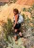
The beginning of the trail by the resort is quite "urban" :( In the interest of time I planned to jog as much of the day as possible where the trails allowed (first ultra is in 1 month!), and managed to overtake everyone else on the trail and reach the subway first so I had it to myself briefly. The turnoff to the subway is almost impossible to miss with how much traffic goes there, but I did encounter a few people later in the full trail who had missed it.
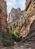
The subway ramp was steeper than I expected. I shimmied up the right-most side. Coming back down I took a far easier path that you would find to the left of the ramp, through a branched archway, that takes you right up to the ruins alcove. I would recommend using that unless you want the challenge of the ramp. Coming back to the main trail, it was easy to take a wrong turn a couple times.
I knew there were other ruins in Boyntonn but ran out of time trying to internet sleuth all my destinations before driving up, and hoped they would be a little more obvious in Boynton. Unfortunately I didn't manage to spot the others, so I plan to go back eventually.
The rest of the trail was pleasant forest trail but not particularly dramatic. The strong smell of pine was wonderful. Upon reaching the end, I once again hoped to spy some ruins from the vantage point but had no luck. Upon returning to the trailhead it was a total zoo. I would guess 200 cars up and down the street spilling out of the lot, people getting dropped at the trailhead, etc. I didn't know yet that you could park along the street, and didn't want to risk getting shut out of Fay parking and losing any spot at all, so I left my car at Boynton and after a pit stop jogged down to Fay with just my tripod in hand.

Fay Canyon - 5.42mi, 909ft AEG, 2:08 elapsed
Fay began with wide, gentle dirt paths. The turnoff to the arch is again quite obvious. I worked my way up beneath the arch for some photo ops. The arch is separated from the cliff, but the gap is narrow so it's difficult to see that from most angles. For that reason I found the pictures better from underneath the arch than on top of it. To get to the top you'll aim to ascend the slope to the right/south of the arch. I followed a well defined path going up and to the right, but it had quite a lot of prickly pear, and a spot or two that narrowed and required some attention to footing. Coming down I tried an alternate path down a rock fall. It had no exposure and no cacti, just lots of large rocks which made a little slower going, so I'd rate the paths about equal. When I reached the bottom a stranger asked if I drove a particular car. They had been at Boynton and saw me go to my car and were hoping to get my spot when they saw me jog off, so they gave up and went to Fay instead. They were good sports about it.
I returned to the main trail and headed up to the fork. I knew ruins would be on the right fork, but didn't know exactly where. I went up the wash and some areas that looked fairly well traveled, and saw plenty of footprints. I went a ways up and down the right fork twice and still found nothing, but the foliage was dense and made it hard to see much. Skipping between rocks in the wash, I managed to roll my ankle fairly hard, but fortunately it didn't catch up with me until the drive home stiffened me up. Gave up looking for the Fay ruins, but at the next canyon received a tip from a traveler about where to find them when I go back.

Long Canyon - 9.12mi, 1385ft AEG, 3:24 elapsed
The whole area was crawling with people by this point, so I parked at the Mescal trailhead and didn't bother going down to check Long Canyon trailhead. Mescal was full, but I was lucky to get a spot from someone leaving. I jogged to the large nexus intersection and briefly took a wrong turn left which I believe heads to the Birthing Cave which I didn't really have interest in.
I reached "butt rock" a couple miles in, and continued up Long trail for now according to plan. After another mile or two, I reached my first point of interest. At a rocky wash with a large pine, there was a small but fairly clear path leading off to the left and switchbacking uphill. Here the path became quite steep, but the section is short. After just a few moments you should see the ladder come into view. Reaching a fork, I headed left first, to a nice Hohokam dwelling. This one may be have been restored at some point, but it was cool nonetheless. I worked my way back to the fork and up the other direction toward the ladder and another small ruin next to it. I shimmied into a small cave behind the ladder for some photo ops.
I did not intend to go further up Long trail, so I headed back to "butt rock" and turned east this time, following a well traveled path. I was glad to encounter a couple other travelers for this stretch which involved a couple small rocky scrambles. The goal is the opening between the ice cream cone rock on the left, and the 3 sisters formation to the right. The ruins were neat, I found it difficult to get a photo angle that showed them off well, they look better in person :) Heading back down solo, I did have to search a few minutes to find the right spot back down over the long ledge.

I changed into clothes that didn't smell bad for the drive home and enjoyed the most overpriced but delicious quarter pounder with cheese in as long as I can remember.
  2 archives
May 21 2021
avatar

 Guides 4
 Routes 93
 Photos 302
 Triplogs 697

51 male
 Joined Jul 05 2008
 Gilbert, AZ
Fay Canyon Trail #53Sedona, AZ
Sedona, AZ
Hiking avatar May 21 2021
adeniumTriplogs 697
Hiking3.23 Miles 557 AEG
Hiking3.23 Miles   1 Hour   30 Mns   2.15 mph
557 ft AEG
 no routesno photosets
1st trip
Linked   none no linked trail guides
Partners none no partners
Pre-birthday day trip up to Sedona for a little hiking. This was hike number two for the day. I had originally thought about Doe Mountain, but the parking lot was packed, so I backtracked to Fay. I remember doing this as one of the first hikes I took with my (then) girlfriend (now wife) 23 years ago. Walked up to the end of the trail and followed the wash a ways until it became choked with vegetation. I had completely forgotten about the arch, and took a side trip up to see that. Neat little canyon.
_____________________
 
Feb 28 2021
avatar

 Guides 69
 Routes 37
 Photos 3,010
 Triplogs 2,387

55 male
 Joined Oct 24 2010
 Phoenix,Az
Fay Canyon Trail #53Sedona, AZ
Sedona, AZ
Hiking avatar Feb 28 2021
mt98dewTriplogs 2,387
Hiking3.25 Miles 155 AEG
Hiking3.25 Miles   1 Hour   35 Mns   2.05 mph
155 ft AEG
 no routesno photosets
1st trip
Linked   none no linked trail guides
Partners none no partners
This has been on my wife’s list for awhile and we were lucky enough to have some time in Sedona. Got up to the TH around 3pm. Cars were literally lining the road from where Boyton Pass Rd “T”d with Boyton Canyon Rd. We were lucky enough to get a parking spot at Fay Canyon TH. Little disappointed about the crowds. But the farther back we went the less it seemed to factor. Trail was nice, though pretty straight for a Sedona trail. The trail was composed of soft powdery red dirt and rose slightly as we hiked in. The canyon walls rose up as we hiked in providing some beautiful Sedona rock formations on display, though the trees and foliage obscured some of the display. Did not hit the arch, as there were several groups up there already. Reach the end of the trail.....forest service was kind enough to place a sign stating such. It was obvious that many people continued on past the sign. Looked like there were three options: straight and up, or follow the canyons to the left or the right. I was surprised and happy to fine that the wife was willing to venture up the left canyon a ways. There were some down trees and rocks that needed to be negotiated as we went back about .25 miles. She handled it like a veteran hiker and actually said she liked this more rugged aspect. Made just past where the fire hit before turning around. Nice time out with the wife. Look forward to coming back and doing a little more exploring
_____________________
 
Jan 24 2021
avatar

 Routes 175
 Photos 2,335
 Triplogs 191

44 female
 Joined Jan 21 2019
 Pine, AZ
Fay Canyon Trail #53Sedona, AZ
Sedona, AZ
Hiking avatar Jan 24 2021
jillyonanadventureTriplogs 191
Hiking3.44 Miles 564 AEG
Hiking3.44 Miles   2 Hrs   10 Mns   1.84 mph
564 ft AEG      18 Mns Break
 
1st trip
Linked   none no linked trail guides
Partners partners
jharvey33
klfranz
Route Scout Route Recorded  on Route Scout | Pop | Map | Popup | MapDEX
We had never been to Fay Canyon and decided to check it out post the Doe Mountain hike. The climb up to the arch is pretty typical Sedona steep-ish. Slippery rocks & muddy shoes made it more of an adventure! :lol: There is a small (not original) dwelling under the arch. We followed the wall up to a faint path that took us on top of the arch (not that impressive up there). It seemed like there could be more dwellings up another level, but the footing was too slippery to scramble safely up there. We headed back down and decided to see what the end of the trail looked like. This was underwhelming to say the least. We did have to direct two hikers that were scrambling up past the trail end, looking for the arch, in completely the wrong spot :? They ended up needing to follow us to the entrance of the side path because they were confused. That was our “good deed” for the day. Fay canyon isn’t my favorite canyon and wouldn’t be next on my list to return. Glad we saw the arch just once though! Next stop I didn’t record, but we headed over to oak creek for some creekside sauntering. I really do love snowdona!
_____________________
Restless between adventures...
 
Nov 27 2020
avatar

 Guides 3
 Routes 632
 Photos 8,235
 Triplogs 604

54 male
 Joined Apr 13 2011
 Gilbert, AZ
Fay Canyon Trail #53Sedona, AZ
Sedona, AZ
Hiking avatar Nov 27 2020
ddgrunningTriplogs 604
Hiking6.76 Miles 1,556 AEG
Hiking6.76 Miles   5 Hrs   13 Mns   1.50 mph
1,556 ft AEG      42 Mns Break
 
1st trip
Linked   none no linked trail guides
Partners none no partners
Route Scout Route Recorded  on Route Scout | Pop | Map | Popup | MapDEX
Took an anniversary day trip up to Sedona for a hike with my sweetheart. I was under strict instructions not to choose something not too long or crazy. Fay Canyon seemed to fit the Bill, and I had never done it before.

We arrived at the TH about 10:30. Still several parking slots available. This one understandably attracts a young crowd and is a great kid-friendly hike. But it also offers a little adventure for the non-kids, with an off-trail side trip to Fay’s Arch, and more exploring up canyon beyond the end of the official trail.

We did both. Enjoyed the arch. Beyond the trail end, we took the north/east spur of the canyon and climbed up the side drainage and back out to an excellent overlook for a great lunch spot.

After lunch, we explored a bit more up canyon for some ruins. After a little extra (and some unnecessary) bushwhacking, we found two sets, one on each side of the canyon, though they were a bit too uniform and had no mortar of other signs of habitation, so we were a bit skeptical of whether their origin was that ancient. Regardless, they were fun to visit.

Took our time on the return and cruised into town for an early dinner at Cafe Jose.

The wife declared it a perfect hike, so mission accomplished!
_____________________
 
Sep 26 2020
avatar

 Guides 33
 Routes 286
 Photos 445
 Triplogs 251

35 male
 Joined Oct 23 2017
 Tempe
Fay Canyon Trail #53Sedona, AZ
Sedona, AZ
Hiking avatar Sep 26 2020
KingLeonidasTriplogs 251
Hiking2.61 Miles 592 AEG
Hiking2.61 Miles   1 Hour   29 Mns   1.84 mph
592 ft AEG      4 Mns Break8 LBS Pack
 
no photosets
1st trip
Linked   none no linked trail guides
Partners none no partners
Hiked Fay Canyon Trail #53 with my Wife, Sister, and Dad as part of my Arizona Birthday Adventure. This was our first time hiking Fay Canyon.

We did this one in the afternoon with the intention of it being a sunset type hike. When we got there the parking lot was basically empty which was a relief given how crowded the rest of Sedona was.

The trail was pretty gradual and a bit sandy which was a relief to some people in the group who struggled earlier in the day with cathedral rock.

We opted to explore try to find the arch. There were several other groups trying to do the same with varying degrees of success. We later found an arrow of sticks and stones that points you in the correct direction from the main trial. The biggest challenge is not getting turned in the wrong direction by the myriad of interconnecting side trails in that area. The trails heading up to the arch are a bit steeper than the main trail and as before my Dad and Sister opted out of the arch side trip on account of the terrain being too steep and poor footwear.

The arch itself runs parallel to the promontory so it isn't apparent that it is an arch until you are right under it. That said, it is pretty impressive once you get there and given enough time it is probably possible to scramble up the sides to get on top of the arch. We didn't attempt that (with half the group waiting the additional excursion would have taken up too much time) but we will have to give it a shot at a later date.

The remainder of the maintained trail was similar to the beginning with the views of the red rock cliffs and the setting sun getting progressively better as time passed.

At the end of the maintained trail there was was a bit of a scramble up the cliff face a bit that gave a fantastic view of the canyon we just ascended. At sunset this was particularly spectacular as there as a mesa profiled nicely in the center of the canyon and the moon was clearly visible overhead. Fay Canyon is definitely an excellent sunset photo op!

This was a great hike, there are lots more places to explore (both at the arch and beyond the end of the maintained trail). I will definitely have to plan a return visit!

Hike video: [ youtube video ]
_____________________
 
Jul 11 2020
avatar

 Photos 5
 Triplogs 1,041

36 female
 Joined Oct 04 2012
 Phoenix, AZ
Fay Canyon Trail #53Sedona, AZ
Sedona, AZ
Hiking avatar Jul 11 2020
WaitingForRainTriplogs 1,041
Hiking2.20 Miles 155 AEG
Hiking2.20 Miles      55 Mns   2.40 mph
155 ft AEG
 no routesno photosets
1st trip
Linked   none no linked trail guides
Partners none no partners
_____________________
 
May 25 2020
avatar

 Guides 2
 Routes 25
 Photos 1,890
 Triplogs 604

41 male
 Joined Sep 13 2009
 Mesa, AZ
Fay Canyon Trail #53Sedona, AZ
Sedona, AZ
Hiking avatar May 25 2020
jochalTriplogs 604
Hiking2.20 Miles 155 AEG
Hiking2.20 Miles
155 ft AEG
 no routesno photosets
1st trip
Linked   none no linked trail guides
Partners none no partners
_____________________
 
Sep 28 2019
avatar

 Guides 4
 Routes 52
 Photos 1,303
 Triplogs 75

female
 Joined Feb 04 2017
 Sun City
Fay Canyon Trail #53Sedona, AZ
Sedona, AZ
Hiking avatar Sep 28 2019
caragrueyTriplogs 75
Hiking2.20 Miles 155 AEG
Hiking2.20 Miles
155 ft AEG
 no routes
1st trip
Linked   none no linked trail guides
Partners partners
Nate_F
Headed out for a short hike with a few friends to check out the arch and other cool things along this trail. We weren't disappointed. The arch is lovely with some pretty nice views once on top. Definitely one I'll plan to bring visiting out of towners to.
_____________________
 
May 24 2019
avatar

 Photos 28
 Triplogs 13

37 female
 Joined Jan 11 2018
 Scottsdale
Fay Canyon Trail #53Sedona, AZ
Sedona, AZ
Hiking avatar May 24 2019
GallydollTriplogs 13
Hiking2.20 Miles 155 AEG
Hiking2.20 Miles   3 Hrs      0.88 mph
155 ft AEG      30 Mns Break
 no routesno photosets
1st trip
Linked   none no linked trail guides
Partners none no partners
It was a beautiful day. I did a easy hike with my dad. We went up to the Fay Canyon Arch. There was a family of crows living on in the rocks. I didn't bring my zoom lens so I lost an opportunity to take a picture of the babies. Than we went to the end of the trail. We turned right and followed the dry wash and found some ruins at the end. We went fairly early so there was not as many people. There was no one at the ruins or the arch.
 
Dec 27 2018
avatar

 Guides 6
 Routes 183
 Photos 5,612
 Triplogs 1,647

male
 Joined Mar 12 2004
 Scottsdale, AZ
Sedona - Mescal Mt / Fay / Pumphouse, AZ 
Sedona - Mescal Mt / Fay / Pumphouse, AZ
 
Hiking avatar Dec 27 2018
John9LTriplogs 1,647
Hiking9.57 Miles 950 AEG
Hiking9.57 Miles
950 ft AEG
 no routesno photosets
1st trip
Headed to Sedona with a friend in hopes of snow and adventure. Snow was forecasted starting late morning and would build as the day progressed. We would spend the day exploring Mescal Mountain, Fay Canyon and Pumphouse Wash.

We started off at the Long Canyon TH and started a CCW loop around Mescal Mountain. We checked out a couple of alcoves and looped around. The views were nice and dark clouds were developing. We completed the loop and then drove over to Fay Canyon. We headed up that canyon and bypassed the arch, we've both been there before, and topped out near the end of the trail sign. During this time a light snow started falling.

After Fay, we ate lunch and then headed up 89A. We opted for Pumphouse Wash. At this point, this entire area had a solid dusting of snow. We parked right outside the wash and headed in. It was slow as we enjoyed this amazing canyon. We took a variety of pics and went about a mile in. At this point it was getting late in the day and we wanted to head back.

The drive home turned into an adventure. We headed north for the I-17 and snow started falling again. We hit the I-17 and found a standstill for miles and miles. We ultimately turned around and headed back down 89A and got home at least two hours later than we should have. Despite this, it was a really nice day. We were a tad early for the snow but got a small taste. This would develop into a solid storm over the next few days.
_____________________
  2 archives
Apr 07 2018
avatar

 Guides 264
 Routes 2,797
 Photos 14,494
 Triplogs 5,894

55 male
 Joined Nov 20 1996
 
Fay Canyon Trail #53Sedona, AZ
Sedona, AZ
Hiking avatar Apr 07 2018
joebartelsTriplogs 5,894
Hiking4.50 Miles 1,600 AEG
Hiking4.50 Miles   4 Hrs   30 Mns   1.29 mph
1,600 ft AEG   1 Hour    Break3 LBS Pack
 
1st trip
Linked   none no linked trail guides
Partners partners
The_Eagle
Returned to Fay 2 months shy of 20 years. Then as a stone cold tourist it registered as done, what's next? My perspective changed minutes into the overdue return. The trail albeit a smidgen sandy for the peanut gallery is wide, easy grade and surrounded by more trees than I recall.

Exploring the upper east canyon was the highlight. I didn't care for the west. The forest was scorched and I was more interested in other planned hikes. Totally wrote it off, later found a reason to return someday.

We hit the obligatory arch on the way out.
wildflower observationwildflower observationwildflower observationwildflower observationwildflower observation
Wildflowers Observation Light
nothing to write home about, best I've seen in this record bone dry year
_____________________
- joe
 
Apr 07 2018
avatar

 Guides 41
 Routes 1,626
 Photos 14,983
 Triplogs 2,760

69 male
 Joined Jan 20 2009
 Far NE Phoenix,
A day with Fay, AZ 
A day with Fay, AZ
 
Hiking avatar Apr 07 2018
The_EagleTriplogs 2,760
Hiking4.64 Miles 1,647 AEG
Hiking4.64 Miles   4 Hrs   38 Mns   1.12 mph
1,647 ft AEG      30 Mns Break12 LBS Pack
 
1st trip
Linked   linked  
Partners partners
joebartels
I'd only been to the Arch on this one.
Today we wanted to do the trail and extend it into some canyon exploration.
We passed but one couple on the way to the sign at the end of one mile, marking the end of the maintained trail.

We opted for the north canyon first. There is a decent use trail that we followed up and around to the right. When we reached the wall on the way up, we went left first, to go around the canyon, to get to the sweet view point.
:next: [ youtube video ]

Next we went right to see it the crack we saw would get us up to the top. Practicing safety first, Joe waited while I went up. There is an interesting slot that you can crawl through to get views of the Canyon you just came up. Next, I passed the Ruins and looked for the remaining route up. I found it, but thought it best to get back to Joe before he tried following... which he was trying. I slapped his nose with a newspaper.

Back, down and off to the other ruins we saw from the previous viewpoint.

Next we were checking out the westerly canyon up here, looking at a potential route to the top of Bear Mountain. From the other side of the canyon we spotted a route that looked "doable". After negotiating it for a bit with no problem, we decided it would be better attacked from above, when we were planning for a longer loop.

We headed back down canyon towards the official end of trail and went west on the use trail there. There were a lot more family type hikers on the beginning portion of this route. This has some worthy views, but is a one and done for me.

We hit the arch on the way out, because we had to.

wildflower observationwildflower observationwildflower observationwildflower observationwildflower observation
Wildflowers Observation Isolated
_____________________
There is a very fine line between "hobby" and "mental illness."
Dave Barry 🦅
  1 archive
Jan 29 2018
avatar

 Photos 326
 Triplogs 124

71 female
 Joined Jan 04 2014
 Phoenix, AZ
Fay Canyon Trail #53Sedona, AZ
Sedona, AZ
Hiking avatar Jan 29 2018
AZBeaverTriplogs 124
Hiking2.54 Miles 492 AEG
Hiking2.54 Miles   1 Hour   19 Mns   2.58 mph
492 ft AEG      20 Mns Break10 LBS Pack
 no routes
1st trip
Linked   none no linked trail guides
Partners partners
AZWanderingBear
Beautiful hike to Fay Canyon in Sedona. I so enjoyed this hike. A fun hike and the views of the forest and the peacefulness of its beauty overcomes you. We still are not sure if we actually saw the Fay Canyon Arch or not.
_____________________
 
Sep 19 2017
avatar

 Routes 22
 Photos 416
 Triplogs 67

42 male
 Joined Apr 18 2009
 Anthem, AZ
Fay Canyon Trail #53Sedona, AZ
Sedona, AZ
Hiking avatar Sep 19 2017
LostTriplogs 67
Hiking3.20 Miles 492 AEG
Hiking3.20 Miles   1 Hour   30 Mns   2.13 mph
492 ft AEG10 LBS Pack
 no routesno photosets
1st trip
Linked   none no linked trail guides
Partners none no partners
_____________________
 
Jun 01 2017
avatar

 Routes 297
 Photos 6,928
 Triplogs 552

49 male
 Joined Dec 30 2007
 Avondale,Az
Robbers Roost - SedonaSedona, AZ
Sedona, AZ
Hiking avatar Jun 01 2017
StoicTriplogs 552
Hiking7.10 Miles 1,867 AEG
Hiking7.10 Miles   9 Hrs   30 Mns   1.18 mph
1,867 ft AEG   3 Hrs   30 Mns Break
 no routes
1st trip
Linked   linked  
Partners none no partners
Day 3 of our adventure in Sedona.
We started the Robbers Roost trail around 2:30am. We hung out at the roost for a couple hours taking pictures and screwing around. The total trip time was about 3 1/2 hours. We then drove to Fay Canyon. We spend 6 hours exploring the canyon and visiting the Arch.


[ youtube video ] Part 1 Robbers Roost.
[ youtube video ] Part 2 Fay Canyon arch and Canyon Exploration.
 Culture
 Culture [ checklist ]
[ checklist ]  Balloon  Mascot
_____________________
 
Oct 02 2016
avatar

 Guides 107
 Routes 249
 Photos 2,067
 Triplogs 514

male
 Joined Nov 18 2005
 Phoenix, AZ
Doe Mountain Trail #60Sedona, AZ
Sedona, AZ
Hiking avatar Oct 02 2016
nonotTriplogs 514
Hiking15.00 Miles 2,900 AEG
Hiking15.00 Miles
2,900 ft AEG
 no routesno photosets
1st trip
_____________________
http://hikearizona.com/garmin_maps.php

Hike Arizona it is full of sharp, pointy, ankle-twisting, HAZmaster crushing ROCKS!!
Hike Arizona it is full of sharp, pointy, shin-stabbing, skin-shredding plants!
Hike Arizona it is full of striking, biting, stabbing, venomous wildlife!
  2 archives
Aug 23 2016
avatar

 Photos 23
 Triplogs 21

48 male
 Joined Jul 31 2016
 Sedona, AZ
Fay Canyon Trail #53Sedona, AZ
Sedona, AZ
Hiking avatar Aug 23 2016
emptypocketsTriplogs 21
Hiking5.03 Miles 492 AEG
Hiking5.03 Miles
492 ft AEG
 no routes
1st trip
Linked   none no linked trail guides
Partners none no partners
Hiked to back of canyon and out

dry Fay Canyon Dry Dry
_____________________
 
average hiking speed 1.76 mph
1, 2, 3, 4, 5  Next

WARNING! Hiking and outdoor related sports can be dangerous. Be responsible and prepare for the trip. Study the area you are entering and plan accordingly. Dress for the current and unexpected weather changes. Take plenty of water. Never go alone. Make an itinerary with your plan(s), route(s), destination(s) and expected return time. Give your itinerary to trusted family and/or friends.

helpcommentissue

end of page marker