username
X
password
register
for free!
help
ArticlesGuidesRoutes
 
Photosets
 
 Comments
triplogs   photosets   labels comments more
Havasu Canyon Trail - 122 members in 312 triplogs have rated this an average 4.7 ( 1 to 5 best )
1, 2, 3, 4, 5 ... 16  Next
312 triplogs
login for filter options
Oct 05 2024
avatar

 Guides 12
 Routes 192
 Photos 863
 Triplogs 356

42 male
 Joined Nov 30 2015
 Phoenix, AZ
Havasu Canyon TrailNorthwest, AZ
Northwest, AZ
Backpack avatar Oct 05 2024
ShatteredArmTriplogs 356
Backpack39.00 Miles 5,500 AEG
Backpack39.00 Miles3 Days   2 Hrs      
5,500 ft AEG
 no routes
1st trip
Partners none no partners
My sister procured a Havasupai permit at the beginning of 2020 - and finally got a chance to use it this year (although the flood in August initially threatened to delay it yet another year). I said a long time ago that I wouldn't bother with the place unless popularity some day wanes, but I saw no reason to decline an invitation.

We got to the TH at around 7:30 am on Saturday. The check-in policies have completely changed since that last time I went down there; the goal seems to be to put the kibosh on unpermitted visits.

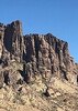
The hike in was unremarkable (although we noted there seemed to be more litter than before); shade much of the way, but it got kinda hot after we passed Supai. The campground was filled to the brim, but we found a good, relatively secluded and convenient campsite that everybody else somehow passed right by (I had the benefit of prior knowledge). The flood seems to have affected all but the ugly desert campsites, but I was expecting the damage to be worse. There was certainly debris scattered around, but the cleanup efforts seem to have been effective.

Sunday the plan was to head down to Beaver Falls, but I couldn't coax her to do the terrifying descent (despite the fact she had already been down there before), so I was on my own. Decided to take advantage and hike all the way down to the Colorado River, since I hadn't done that in ten years and who knows if I'll ever have another chance... The trail past Beaver Falls was easier to follow than I remembered, and I was even able to jog parts of it. Saw a giant rafting party at the confluence, topped off water, then after a 10 minute or so break, headed back up. On the way back up from Beaver, I saw many of the same people I had seen on the way down. I found the climb up the chains to be far more comfortable after waiting for the trail to clear out so I can go at the pace I want.

Monday we headed up to Fifty Foot Falls, which we had to ourselves for the better part of an hour, surprisingly. The new Navajo Falls looked unrecognizable from what I remembered from previous trips. On the way there a bunch of Supai were out clearing the rocks from the trail up from Havasu Falls. Soaked in the pool below Havasu Falls for awhile, then headed back for lunch.

Got up bright and early for the hike out, leaving at around 4:45am. Only had to deal with about a half mile of direct sunlight, so the temperatures were not bad.

It was nice seeing the place again after a really long absence, but with the crowds, it's not quite the same as it used to be. Still wasn't hard to find seclusion, though.
_____________________
  1 archive
Feb 04 2023
avatar

 Routes 6
 Photos 31
 Triplogs 21

26 female
 Joined Jun 21 2022
 Tempe, AZ
Havasu Canyon TrailNorthwest, AZ
Northwest, AZ
Backpack avatar Feb 04 2023
ktcrossTriplogs 21
Backpack25.00 Miles 2,995 AEG
Backpack25.00 Miles
2,995 ft AEG45 LBS Pack
 no routes
1st trip
Linked   none no linked trail guides
Partners none no partners
Grateful to have enjoyed Havasu. Evidence of flooding from 2020 in the area; lots of debris and unstable ground. Some people at the campground mentioned they didn't start prepping for the campers until last week of January. They are working through a lot of controlled burning. Had to hitch a ride off the I-40 with friends to make it to check-in. Did you know Hyundai had an engine recall? Wish I knew.

Must check-in before noon of arrival date (day before is fine), no camping at trailhead.
.

Day 1: Hike in - 11.25 miles to site at 4 hrs 15m.
Day 2: To Beaver Falls - 8 miles took all day
Day 3: To Supai twice to talk to Pep Boys(Friends went to the confluence)
Day 4: Hike out - 5 hours of pain
 Fauna
 Fauna [ checklist ]
[ checklist ]  Bighorn Sheep
_____________________
It is how you live it.
  2 archives
Nov 08 2019
avatar

 Routes 26
 Triplogs 282

39 male
 Joined Apr 14 2019
 Phoenix, AZ
Havasu Canyon TrailNorthwest, AZ
Northwest, AZ
Backpack avatar Nov 08 2019
richvoskoTriplogs 282
Backpack10.30 Miles 2,700 AEG
Backpack10.30 Miles
2,700 ft AEG
 no routesno photosets
Linked   none no linked trail guides
Partners none no partners
 
Nov 05 2019
avatar

 Routes 26
 Triplogs 282

39 male
 Joined Apr 14 2019
 Phoenix, AZ
Havasu Canyon TrailNorthwest, AZ
Northwest, AZ
Backpack avatar Nov 05 2019
richvoskoTriplogs 282
Backpack10.30 Miles 500 AEG
Backpack10.30 Miles
500 ft AEG
 no routesno photosets
Linked   none no linked trail guides
Partners none no partners
 
Mar 28 2019
avatar

 Routes 27
 Photos 279
 Triplogs 56

39 male
 Joined Aug 06 2009
 Phoenix, AZ
Havasu Canyon TrailNorthwest, AZ
Northwest, AZ
Hiking avatar Mar 28 2019
nathanbriskTriplogs 56
Hiking20.52 Miles 3,310 AEG
Hiking20.52 Miles
3,310 ft AEG45 LBS Pack
 
Linked   none no linked trail guides
Partners none no partners
Good hike in and out of the Havasupai campground. We hiked in Thursday and out Sunday.

The mules--as always--showed no signs of abuse.
_____________________
 
Nov 22 2018
avatar

 Routes 386
 Photos 49
 Triplogs 792

43 female
 Joined Jun 23 2015
 Phoenix, AZ
Havasu Canyon TrailNorthwest, AZ
Northwest, AZ
Backpack avatar Nov 22 2018
emilystardustTriplogs 792
Backpack24.00 Miles 2,995 AEG
Backpack24.00 Miles3 Days         
2,995 ft AEG
 no routesno photosets
Linked   none no linked trail guides
Partners none no partners
_____________________
 
Nov 12 2018
avatar

 Routes 137
 Photos 1
 Triplogs 105

44 female
 Joined Oct 21 2016
 Tempe, AZ
Havasu Canyon TrailNorthwest, AZ
Northwest, AZ
Backpack avatar Nov 12 2018
MAPTriplogs 105
Backpack10.20 Miles 17 AEG
Backpack10.20 Miles
17 ft AEG
 
no photosets
1st trip
Linked   none no linked trail guides
Partners none no partners
November is much colder up north then us Phoenicians realize! We pulled up to the trailhead in the morning and I think the temp was about 28 deg F. I kept telling myself I could do it despite a huge lingering fear that I might freeze to death even though I was well prepared for camping in the cold (just a little dramatic). The hike down was beautiful. I can only imagine what it was like before hoards of people started coming. It was definitely difficult seeing the injured overworked horses carrying the excess people insist on having down there. If you are reading this and thinking of going, please pack your own stuff in and out. It is a hike to a remote area and people seem to treat it as if it should be a resort stay.

The campground is a little piece of paradise with blue-green streams flowing through. We brought a water filter. There is water everywhere and also people everywhere soooo better safe then sorry. :sk: You can camp anywhere and there are buildings with composting toilets throughout the campground. Since we were in a canyon, the temp was a few degrees higher than on top of the canyon so the nighttime lows were about 34 deg. My camping gear and clothing did what it was supposed to do and I was actually very comfortable during the nights. We hiked almost to the confluence with the Colorado River the 2nd day. The waterfalls are beautiful of course but the hike downstream from Mooney Falls truly feels like being transported to some secret fairyland that you may just be dreaming of. I'm grateful to have had the opportunity to experience this place but don't have an interest to go back again. The rest of my group was better able to take in the beauty and ignore that every single person we saw there had a camera in their hand and most were treating the place as simply a backdrop for their personal photo sessions. Arizona has so many incredible places and I think I'll stick with the less traveled ones.
_____________________
 
Nov 03 2018
avatar

 Routes 27
 Photos 279
 Triplogs 56

39 male
 Joined Aug 06 2009
 Phoenix, AZ
Havasu Canyon TrailNorthwest, AZ
Northwest, AZ
Backpack avatar Nov 03 2018
nathanbriskTriplogs 56
Backpack11.54 Miles 3,720 AEG
Backpack11.54 Miles   8 Hrs   27 Mns   1.76 mph
3,720 ft AEG
 
Linked   none no linked trail guides
Partners none no partners
The pack animals have not been seriously abused, and that is a serious accusation that shouldn't be leveled against the Havasupai Tribe lightly.
_____________________
  2 archives
Oct 29 2018
avatar

 Photos 104
 Triplogs 47

32 female
 Joined Oct 17 2016
 Phoenix
Havasu Canyon TrailNorthwest, AZ
Northwest, AZ
Hiking avatar Oct 29 2018
peculiargalexyTriplogs 47
Hiking19.10 Miles 2,995 AEG
Hiking19.10 Miles
2,995 ft AEG
 no routesno photosets
1st trip
Linked   none no linked trail guides
Partners none no partners
Got invited as a last minute attendee on this trip. Only got to stay for one night but this place absolutely blew my mind. The water really is that blue. It was such a cool experience and my first backpacking trip. Having slept for four hours the night before I was not the happiest at being awake at 5 am and hiking down into the canyon. But along the way we ran into some people that my friend new and ended up sticking with them through the whole trip and boy was I glad that we did. Turns out I don't know anything about backpacking and now I know a lot more.

We arrived at the village around 9 am and got our wristbands. After grabbing some food in the cafeteria and waiting forever for it to be cooked we finally headed down to the campsite. It was truly something else. Catching our first glimpse of the river halfway there we stopped to take pics and marvel at the water. Then we made it to Havasu falls and I stood there in awe of this huge roaring waterfall. First time I've ever seen a "big" waterfall. Finally made it down to choose the best campsite right by the top of Mooney falls. Set up camp and ate a snack before heading down to Mooney and getting to see the most famous Arizona waterfall. The hike down was awesome- slick and wet and slippery. But those caving skills came in handy again and I wasn't nervous. We hiked down past the falls into a side canyon where we enjoyed a steak cooked over a jetboil. Most delicious meat I've ever eaten.

Afterwards we headed back to camp for dinner before going out and checking out Havasu falls. As it grew dark we went to explore this abandoned mine. The rock inside was absolutely beautiful and getting to check out the mine made my caver side happy. Afterwards we sat under the stars admiring them against the glare of the full moon before finally heading to bed.

In the morning we packed a breakfast and headed to Beaver Falls to see the famous waterfalls. I managed to get in the cold water and waded deeper upriver to explore. Saw some of the most unique beautiful scenery. The hike to Beaver Falls was one of my favorite. It was like being in a jungle...in the bottom of a canyon. So amazing :D

Did about 30 miles in two days. Blew my mind that my body was strong enough to do that with a 35 lb pack but it was pretty amazing and I definitely cannot wait to do more backpacking trips!

Need trail info? PM me.
_____________________
  1 archive
Sep 26 2018
avatar

 Photos 5
 Triplogs 1,041

36 female
 Joined Oct 04 2012
 Phoenix, AZ
Havasu Canyon TrailNorthwest, AZ
Northwest, AZ
Hiking avatar Sep 26 2018
WaitingForRainTriplogs 1,041
Hiking11.00 Miles 2,995 AEG
Hiking11.00 Miles   5 Hrs      2.20 mph
2,995 ft AEG
 no routesno photosets
Linked   none no linked trail guides
Partners none no partners
_____________________
  2 archives
Sep 24 2018
avatar

 Photos 5
 Triplogs 1,041

36 female
 Joined Oct 04 2012
 Phoenix, AZ
Havasu Canyon TrailNorthwest, AZ
Northwest, AZ
Hiking avatar Sep 24 2018
WaitingForRainTriplogs 1,041
Hiking11.00 Miles 2,995 AEG
Hiking11.00 Miles   4 Hrs      2.75 mph
2,995 ft AEG
 no routesno photosets
Linked   none no linked trail guides
Partners none no partners
_____________________
 
Jul 05 2018
avatar

 Guides 33
 Routes 286
 Photos 445
 Triplogs 251

35 male
 Joined Oct 23 2017
 Tempe
Havasu Canyon TrailNorthwest, AZ
Northwest, AZ
Hiking avatar Jul 05 2018
KingLeonidasTriplogs 251
Hiking13.50 Miles 1,543 AEG
Hiking13.50 Miles   4 Hrs   42 Mns   2.90 mph
1,543 ft AEG      3 Mns Break31 LBS Pack
 no routesno photosets
1st trip
Linked   none no linked trail guides
Partners none no partners
I got a last minute invite to join a party of four friends on a 3-day 2-night Havasupai trip. I immediately jumped on the opportunity given how difficult and expensive it is to get permits. We started our trip the evening of the 4th of July and drove up to Seligman where we stayed in a motel for the night and consolidated our gear for the next morning's departure.

The drive from Seligman to the trailhead was quite interesting. We woke up at 4 in the morning so that we could beat the sun to the bottom of the canyon. We were one of the first people up and the road to the trailhead offered unparalleled wildlife viewing. We saw just about every conceivable type of fauna on the way in. Cows, elk, javelinas, rodents, rabbits, lizards, and birds of all types were all along the roadway and occasionally in it. On the way in we also passed the Grand Canyon Caverns and Campground. Given how questionable the lodgings in Seligman were we may opt to stay there next time and check out the caverns.

After a quick pit stop we started down the trail into the canyon. We were one of the first groups to set off that morning but the parking lot was still full, the hikers coming out had not reached the top yet and their vehicles occupied most of the available spaces. The descent was moderately steep and rugged or the first mile or so but soon levelled out to a nearly flat walk for the remaining eight miles.

We stopped regularly to take in the striking contrast between the red canyon walls in the piercing blue sky. The otherwise quiet hike was occasionally broken up by mule trains going past at a rapid pace. We stepped off the trail several times to allow them to get by. As we approached Supai Village we could also see helicopters going in and out for about an hour in the morning.

Supai village was still pretty sleepy when we passed through. There were several general stores but only one of them and the camping office where open at 8:30 when we arrived. We stopped in the office, picked up our wristbands, and checked in before continuing on to the campsite. We caught our first views of Navajo and Havasu falls on the way past.

As one of the first groups to arrive we had our pick of the campsites. We selected a well shaded spot near Fern Spring which is the only drinking water source available in the campsite that does not require purification. The sheltered location proved to be a good one with the temperature continuing to rise as the morning went on. Taking stock after the descent we found that we averaged a speed of 3 miles an hour. This good time was partly the result of effective trip planning and relatively light weight packs but mostly due to the group leader's tendecy to go at rapid pace. On the descent everyone in the party consumed around 3 liters of water even with the early start.

Having selected our campsite and pitched our tent we moved on to the problem of food storage. In the short time it took us to pitch our tent we already saw one of our neighbor's unsupervised packs get raided for food buy an opportunistic squirrel. We brought monofilament fishing line for hanging food bags but found that it was of inferior quality and could not bear anywhere near it's rated load limit. Fortunately five gallon buckets and coolers were available for food storage. These were able to defeat even the most ambitious rodents although it was necessary to place rocks on top of the lids to keep them out. Vigilance was required at all hours of the day and night with mice making attempts on the food stores at times when squirrels were asleep.

Having staked our claim and relaxed a while we were ready for a bit of adventure. We decided to check out the nearer waterfalls by first heading south and hitting Havasu, Navajo, and the like and later heading north through the campsite and doing Mooney before calling it a day. Our first stop was Havasu.

Havasu Falls were very impressive and they're probably the most photographed of the lot as they are the easiest to get to. The base of the falls was deep enough for swimming and the rapid flow allowed for an endless pool type of experience. You could swim as fast as you liked but never reach the point where the falls hit the water, one of our party tried his hardest and managed to get very close. There is a series of travertine basins in the immediate vicinity of the falls and they make great spots to relax and soak tired limbs after the hike in.

Photography was somewhat difficult at this fall and indeed at all of the falls. The mist and spray from moving water tended to coat camera lenses and make all the shots blurry. The scuba diver's trick of using saliva to coat the lens did allow for the GoPro lens cover to remain clear enough, long enough, for most shots. I did end up having to use vinegar to get the calcium deposits off the lens after the trip. Water and a soft cloth could not remove the residue from multiple days of spray exposure.

We didn't get to try this but our neighbors at the campsite mentioned that it is possible to take an inner tube and ride lazy river style from Havasu Falls all the way to the camp. We did not bring any inner tubes with us but there was no shortage of floaties abandoned by other hikers prior to hiking out. The natives ought to set up an inner tube rental program; they could make a bundle and spare themselves considerable clean-up efforts! We saw a wide variety of pack lightening attempts from individuals hiking out. The funniest was probably the group that ran their camping stove for an hour with nothing on it to burn off all the fuel and reduce their pack out weight.

Having got our fill of Havasu Falls and a bit of Nutella and honey fry bread from one of the huts we continued heading south up the canyon. Two of the party had done a Havasupai trip before and were familiar with the more common sites. One of them had heard of a "Hidden Falls" that apparently had a spot for cliff jumping. We went in search of the spot.

The "Hidden Falls" were true to their name and required some bushwhacking to get to. Heading south up the trail from Havasu Falls there are several river access points on the right hand side. We took one that had a small thatched awning near it. After reaching the river we begin wading upstream and rock hopping where there was no trail to follow. The path forward was not too difficult but definitely not obvious unless you knew what you were looking for.

After rounding a bend the "Hidden Falls" came into view. Of the waterfalls we visited they were my favorite. The pool at the base was deep and very wide which made cliff jumping fun and easy. The elevation of the cliff available was moderate. It was probably taller than The Crack at Wet Beaver Creek: lower cliff but was definitely lower than the upper cliff at that location.

In addition to the cliff jumping, the "Hidden Falls" also had a grotto behind the waterfall that could be reached by clambering along the right hand side using the rocks to pull yourself along against the current. The grotto was big enough for the group to sit in comfortably and be completely obscured from the outside world. We exited the grotto the way we came in. None of us were brave enough to go out the fast way by plunging directly into the falls without scuba gear. We thoroughly enjoyed our time at the "Hidden Falls" and research after the trip found them to be called the Lower Navajo Falls or Rock Falls. Their location was mapped via GPS and a pin for them added to Hike AZ.

At this point we were starting to get tired and were glad to find that Navajo Falls were not far head. Navajo Falls were accessible at both the top and the base. At the top the water was generally shallow and one could walk right up to the edge in many places. Navajo Falls were not as tall as Havasu and had less space to swim at the base. That said, they did offer a fantastic view from the bottom as they wrap around the basin in a semicircle. Placing yourself in the middle of that semicircle affords an extraordinary panorama. There were also sections along the right-hand side of the falls where one could walk under the falling water. The water was probably low flowing at the time we were there so this opportunity may not always be present.

It was well into to the afternoon at this point and we could feel the heat radiating off the sand and dirt through our water shoes. We retraced our steps to and through campsite and arrived at the top of Mooney Falls.

I am glad we saved this waterfall for last as it was far more impressive than Havasu Falls being much taller and having a larger pool at the base. However in some ways the excitement of discovering Money was overshadowed by the thrilling approach. To get from the top to the base of the falls one must climb down a path of extremely steep rock that is perpetually wetted and slippery due to spray from the falls. As protection there were chains and pallet ladders covering the more vertical sections.

Even with the protective equipment the going was quite slow and was single file for much of the way. The descent is not for the faint of heart or for those afraid of heights. A rescue basket sat at the bottom as evidence of regular panic attacks on the part of unprepared participants. Having done some rock climbing myself I would have felt more comfortable rappelling down the side then using the questionable chains and ladders. We gradually got used to the idea and we made the passage four times over the course of the trip.

The base of Mooney Falls is quite large, so large that there are a few picnic tables, some actually in the water, for hikers to rest at and have their lunch. There is also the rope swing that was so heavily featured on social media and caused the most recent boom and Havasupai popularity. Having arrived there late in the day we were able to monopolize the rope swing for quite a while. We stayed at the bottom of Mooney Falls until it started to get cold at which point we climbed back up the treacherous path and return to our campsite for the night.

Over our dinner of pea soup and a cup of sangria from the bladder I had been discreetly chilling in the river all day we discussed tomorrow's plans. We contemplated doing a hike to the confluence of the Colorado River and Havasu Creek and decided to go for it tomorrow morning. We planned to hit Beaver Falls along the way. A round of hearts finished off the night and the weather which had been cooling steadily as the evening progressed took a strange turn. The wind changed direction shortly before we went to bed and the temperature increased almost instantly by what felt like 10 or 15 degrees. It went from cool and refreshing to sweltering in under a minute. This hot condition would persist the entire night and the second night a similar phenomenon would occur. I do not know if this is normal in Havasupai or if it presaged a coming storm. It is possible it was the latter; the week following our trip there was severe flash flooding in Havasupai campgrounds which we were fortunate enough to miss.

I went into this trip with high expectations given all the hype and popularity. Havasupai did not dissapoint and would reward us with an even greater adventure on our second day...

Link to topographical maps and field notes: https://plus.google.com/u/0/photos/1166 ... sSuk7iMpwE

Link to trip video: [ youtube video ]

A gear list is available in "my packs" on Hike AZ: see Havasupai 3D 2N (personal gear) and Havasupai 3D 2N (shared gear)


water 1 out of 5water 2 out of 5water 3 out of 5water less than max Fern Spring - Havasu Gallon per minute Gallon per minute
This is an odd spring. It is a PVC pipe sticking out of the canyon wall with no valve (it runs continuosly). We were told that it does not require purification and no one in the group has gotten sick the last 2 trips so it must be ok.

water 1 out of 5water 2 out of 5water 3 out of 5water 4 out of 5 Havasu Falls Heavy flow Heavy flow
Roaring, made a nice endless pool!

water 1 out of 5water 2 out of 5water 3 out of 5water 4 out of 5 Lower Navajo Falls Heavy flow Heavy flow
Flowing rapidly. Had to clamber along the rocks on the right hand side to reach the grotto. Deep and a good spot for cliff jumping.

water 1 out of 5water 2 out of 5water 3 out of 5water 4 out of 5 Mooney Falls Heavy flow Heavy flow
Roaring and throwing enough spray to keep the approach wet and slippery

water 1 out of 5water 2 out of 5water 3 out of 5water 4 out of 5 Navajo Falls Heavy flow Heavy flow
calf deep at the top but swimmable at the bottom. The entire semicircle was flowing
_____________________
 
May 06 2018
avatar

 Guides 59
 Routes 1,100
 Photos 1,176
 Triplogs 1,290

male
 Joined Jan 01 2023
 Arizona
Havasu Canyon TrailNorthwest, AZ
Northwest, AZ
Backpack avatar May 06 2018
pseudalpineTriplogs 1,290
Backpack10.13 Miles 2,699 AEG
Backpack10.13 Miles
2,699 ft AEG
 no routesno photosets
Linked   none no linked trail guides
Partners none no partners
  2 archives
May 04 2018
avatar

 Guides 59
 Routes 1,100
 Photos 1,176
 Triplogs 1,290

male
 Joined Jan 01 2023
 Arizona
Havasu Canyon TrailNorthwest, AZ
Northwest, AZ
Backpack avatar May 04 2018
pseudalpineTriplogs 1,290
Backpack10.14 Miles 419 AEG
Backpack10.14 Miles
419 ft AEG
 no routesno photosets
Linked   none no linked trail guides
Partners none no partners
 
Apr 15 2018
avatar

 Photos 326
 Triplogs 124

71 female
 Joined Jan 04 2014
 Phoenix, AZ
Grand Canyon River Running, AZ 
Grand Canyon River Running, AZ
 
Hiking avatar Apr 15 2018
AZBeaverTriplogs 124
Hiking25.00 Miles
Hiking25.00 Miles
 no routes
1st trip
This is my 4th Colorado River rafting trip with Hatch River Expeditions,through the Grand Canyon--12 glorious days below the rim! I went with my sister, Rita, and best friend Linda Brady. We traveled from Lee's Ferry all the way to Whitmore Wash, 188 miles down the Colorado River taking in both the Upper and Lower Canyon. These motor rigs are 35' in length and 16' wide powered by a 30-horsepower, four-stroke motor. They have two tubes on the sides which you can ride in rapids if you want a great thrill! There were only 14 passengers and 2 crew and one boat this time. I highly recommend saving your $$ for this trip of a life time. It's not cheap, but worth every penny if you are adventurous, love to hike fairly difficult hikes and don't mind camping on the beach every night. You'll get to HATE SAND! But, heck, it's only sand. I keep saying "this will be the last time I go on this trip", but I already miss it. Never say never! If any of you are thinking of going on this trip and want a few good tips, message me.
_____________________
  1 archive
Apr 14 2018
avatar

 Photos 71
 Triplogs 3

56 male
 Joined Apr 17 2015
 Goodyear, AZ
Havasu Canyon TrailNorthwest, AZ
Northwest, AZ
Backpack avatar Apr 14 2018
aviedelsonTriplogs 3
Backpack19.10 Miles 2,995 AEG
Backpack19.10 Miles
2,995 ft AEG35 LBS Pack
 no routes
1st trip
Linked   none no linked trail guides
Partners none no partners
Silvia and I car-camped at Hualapai Hilltop Thursday night.
Cold evening (low of 43 F) ... woke up at 6:30 went outside the vehicle and found some hikers outside standing/looking/commenting about my passenger rear tire (flat)... So the trip began with a little repair work.

Made the mistake of not printing the reservations and phone would not get signal at the reservation shack - Lady there told us "just go down and they'll get your emailed reservations in town below." Thoughts of being turned around at the bottom entered my head, for a moment.

Headed down.

Found camping just after the first restrooms by the creek - beautiful! Broke out the tent and hung up the food (as the forums instruct). Went exploring downstream to the cave entry at Mooney - then came back and hit the hay.

Up Sat am and prepped a day pack - about to leave and noticed a slightly better campsite, so last moment decided to move camp.
Got to Mooney tunnel at 9:30am (line of about 30... VERY slow)... watched other late comers stack up behind us and figured we could have beat this if we got here at 8am ... (next time).

Was quite surprised at how risky the descent was - lots of mist and very slippery chains and ladders. The down-climb is a very cool side experience to this canyon.

Below Mooney was an absolutely beautiful flat, whitemud, shallow lagoon - absolute heaven.
Further down towards Beaver, another fantasy lagoon opens up through a triangle shaped tunnel - immediately to the right a ladder climb. This place is surreal!

Got to Beaver for a swim and exploration. . . Then back upriver to the campsite. At Mooney, we got an opportunity to climb out with no wait - 120 seconds later at the top - exhilarating.

3pm and the Frybread stand opened... huge line. 1 hour wait for the food after ordering - helicopter landing was a hilarious spectacle seasoning everyone's frybread with the talcum-like canyon sand while hiker diners covered their eyes. The helo was for gear delivery - - hikers' Bags dropped into piles of mule dung - See, folks you are better off carrying your stuff in and out.

Next morning, 7am start. Chasing Silvia with all my strength - At Hualapai at 11:55. 3 days is the way to go. Next time, going to try for the confluence. Definately going to reorder my pack and try to knock off 10 lbs. Maybe a hammock.
Loved this hike! Loved it!!


_____________________
 
Apr 01 2018
avatar

 Guides 6
 Routes 183
 Photos 5,612
 Triplogs 1,647

male
 Joined Mar 12 2004
 Scottsdale, AZ
Havasu Canyon TrailNorthwest, AZ
Northwest, AZ
Backpack avatar Apr 01 2018
John9LTriplogs 1,647
Backpack35.00 Miles 5,000 AEG
Backpack35.00 Miles3 Days         
5,000 ft AEG
 no routes
Partners none no partners
I made the trip here 7 months earlier and had no plans on returning anytime soon. That all changed when my friend Sabine had a trip fall through. She wanted to go and I needed little convincing. We were both following a Facebook Group and permits frequently went on sale. We got lucky and scored two permits from a great group out of SoCal. We made the arrangements and were on our way a few days later.

We drove up on Saturday night and headed through Prescott. It was a nice drive because there was no rush. I generally took my time and had quite the adventure on the final 60 miles to the Hilltop. Along the way we found an Elk in the middle of the road and a baby cow trotting farther down. I kept to a reasonable speed and didn’t have any issues. Please drive this road in care, especially at night. We arrived at the Hilltop at 10pm and slept in the jeep.

Our first full day had us up around 6am. The plan was for us to start around 7am and the rest of the group will be about an hour behind. We hit the trail a few minutes late and headed down. I wanted to set a slow and comfortable pace for Sabine. She has never backpacked before and I don’t want her to hate it. We divided the gear beforehand & I was carrying roughly 43lbs vs Sabine carrying 23lbs. This was a good ratio. For the most part, I let her set the pace as we worked our way down canyon. We made good time as we took a variety of pics and talked to groups hiking out. After a few hours we arrived at the village and headed for the permit office where we got comfy and waited for the permit holder.

A short time later our group leader walked into the village and handed out the permits. From there, we headed down canyon and took a short break by Fiftyfoot falls and Navajo Falls. After that, we headed down to the campground and picked a site off to the side. Most of the good sites along the creek were already taken. The rest of the afternoon was spent exploring the general area and I treated myself to some fry bread smothered in Nutella. Was so yum!

We woke on day two and left fairly early to head down canyon. We descended the Mooney Chains and then headed down canyon. We went at a moderate pace and I kept us on track. With much effort, we reached the Confluence and took a long break there. There were roughly a dozen hikers there and no rafters. We really enjoyed the area! After we had our fill, we headed back up canyon. It was sunny and warm as we took our time. The first few miles were slow going and I was happy to arrive at Beaver Falls. Once there we took another break and took a variety of pics. After that, we returned to camp and settled in for the night.

We woke early on day three and packed up and started out. I let Sabine set the pace as we took our time. We took a variety of breaks along the way and went slow and easy. The final 1.5 miles to the top were especially slow going but we made it. Once up top, we packed up and started the drive home. We devoured some Mexican Food in Prescott and were back in Phoenix around mid-afternoon. Was a really fun trip!
_____________________
  2 archives
Mar 31 2018
avatar

 Routes 27
 Photos 279
 Triplogs 56

39 male
 Joined Aug 06 2009
 Phoenix, AZ
Havasu Canyon TrailNorthwest, AZ
Northwest, AZ
Hiking avatar Mar 31 2018
nathanbriskTriplogs 56
Hiking9.99 Miles 2,981 AEG
Hiking9.99 Miles   5 Hrs   19 Mns   2.09 mph
2,981 ft AEG      32 Mns Break
 
Linked   none no linked trail guides
Partners partners
Elavelle
_____________________
 
Mar 28 2018
avatar

 Routes 27
 Photos 279
 Triplogs 56

39 male
 Joined Aug 06 2009
 Phoenix, AZ
Havasu Canyon TrailNorthwest, AZ
Northwest, AZ
Hiking avatar Mar 28 2018
nathanbriskTriplogs 56
Hiking8.20 Miles 585 AEG
Hiking8.20 Miles   4 Hrs   22 Mns   2.00 mph
585 ft AEG      16 Mns Break
 
Linked   none no linked trail guides
Partners partners
Elavelle
_____________________
 
Sep 22 2017
avatar

 Guides 94
 Routes 840
 Photos 22,055
 Triplogs 1,993

52 male
 Joined Sep 18 2002
 Tempe, AZ
Havasu Canyon TrailNorthwest, AZ
Northwest, AZ
Backpack avatar Sep 22 2017
chumleyTriplogs 1,993
Backpack22.14 Miles 3,430 AEG
Backpack22.14 Miles3 Days         
3,430 ft AEG
 
Linked   none no linked trail guides
Partners partners
Jabreme
John9L
Jane texted me a few weeks ago to tell me she had a couple of extra permits to Havasupai. Perfect! It had been forever since I had been down there, and while I'm not one for the CF that this place has become, I hadn't previously made it to the Colorado and I decided this would be a good opportunity to do so without putting effort into the whole permitting process. Since we had friendmooned with her a year ago in Kauai, it was no problem for 9L to take the other permit spot.

Jane's 68 year old father :app: , 9L, and I were the only ones in the group who had been to Supai before, so it was fun to watch the others experience it for the first time. It's hard to believe it was 22 years ago when I first visited this amazing place! :o (and 16 years since the last visit!)

We met up with the others at our rental house at Grand Canyon Caverns Thursday night and headed out separately on Friday morning. We caught up with them in the village before 11 after a 2.5 hour hike to town. It was an extra 35 minutes until we got to camp. After setting up we set out to explore whatever all the upstream falls are called now. I also managed to find the old Navajo Falls and got a picmimic of how they look now.

Saturday we dayhiked to the Colorado and back (separate triplog) and Sunday morning we headed out at about 7, making it to the "hilltop" -- I like how that name makes it sound like you're not actually hiking out of the Grand Canyon-- in under 3.5 hours.

Wanting to avoid Sunday traffic on I-17, we took an alternate route home. Google said it was only 2 miles longer. West on Route 66 past Peach Springs and then south on Hackberry Road / CR141 which is 19 miles of nicely graded dirt road that connects to US93 north of Wikieup then down through Wickenburg. I think this is an excellent alternative that skips Prescott Valley and the I-17 weekend BS.

Good to see @nathanbrisk at the campground and another car parked at the TH with a HAZ sticker.

Random notes: The bathrooms are surprisingly nice now. The cops are militarized, driving around in OHVs fully-decked out in body armor and carrying weapons and radios-- strangely, I thought this was a positive improvement from past trips. The negative was the organized groups. They use the horses to haul huge coolers of food, stoves, propane, etc. to the campground and then all gather together in close proximity. We spoke to some who had spent THOUSANDS of $$ to visit. Part of the organized groups included yoga and massage tables at the base of the falls. That part of it just seemed ridiculous to me. The line for people waiting get on a helicopter in the morning was 30 deep before first light. Many could have made it out faster by hiking ... if they wanted to!

All in all, it wasn't nearly as bad of an experience as I expected it to be. The scenery is of course unmatched, and the whole thing seems to be managed about as well as you could hope for.
 Fauna
 Fauna [ checklist ]
[ checklist ]  Ringtail
 Culture
 Culture [ checklist ]
[ checklist ]  Cag Shot  HAZ PicMimic

water 1 out of 5water 2 out of 5water 3 out of 5water 4 out of 5 Fern Spring - Havasu Gallon + per minute Gallon + per minute
Nice flow from the pipe. I didn't see anybody filter. Tasted great.

water 1 out of 5water 2 out of 5water 3 out of 5water less than max Fiftyfoot Falls Medium flow Medium flow

water 1 out of 5water 2 out of 5water 3 out of 5water less than max Havasu Falls Medium flow Medium flow

water 1 out of 5water 2 out of 5water 3 out of 5water 4 out of 5 Havasu Springs Gallon + per minute Gallon + per minute
Didn't see the spring source, but the creek is running like it usually is!

water 1 out of 5water less than maxwater less than maxwater less than max Hualapai Canyon Pools to trickle Pools to trickle
Dry except for some pools where the trail crosses it about half a mile up from the end of the canyon

dry Navajo Falls Dry Dry

_____________________
I'm not sure what my spirit animal is, but I'm confident it has rabies.
  1 archive
average hiking speed 2.28 mph
1, 2, 3, 4, 5 ... 16  Next

WARNING! Hiking and outdoor related sports can be dangerous. Be responsible and prepare for the trip. Study the area you are entering and plan accordingly. Dress for the current and unexpected weather changes. Take plenty of water. Never go alone. Make an itinerary with your plan(s), route(s), destination(s) and expected return time. Give your itinerary to trusted family and/or friends.

helpcommentissue

end of page marker