|
| | | |
| |
|
| Hiking | 6.80 Miles |
626 AEG |
| | Hiking | 6.80 Miles | 2 Hrs 5 Mns | | 3.26 mph |
| 626 ft AEG | | | | |
|
|
| |
| Linked |
|
none
[ show ]
| no linked trail guides |
| Partners |
|
none
[ show ]
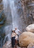
| no partners | | Stayed in Camp Verde for the night, so I had an easy drive to Sedona for this first hike. I got to the Huckaby TH around 6am. I was a little ginger starting out. I had developed blisters on my toes on both feet from my Kendrick hike and my feet were not as excited as I was about doing this hike. At first, this trail is unimpressive as you drop into and climb out of Bear Wallow Canyon. The trail is more of a road and is very unimaginative as it negotiates the canyon. But as it climbs out of the canyon it turns into a single track and becomes much more engaging. At about .75 miles, there is a bench with a nice overlook of Sedona. For about the next mile it maintains the elevation gained, following the contours of the rim of the canyon. Some nice views along the way, especially as the morning sunlight begins to highlight the Sedona peaks. At about 1.8 miles the trail drops into Oak Creek Canyon. The trail hugs the canyon wall, so even though you can hear the water, you don't see it. As you go along the trail, there are numerous side trails that branch off and head to the water. I didn't explore any of these, as I was on a time limit, and wanted to finish the trail. I reached the water soon enough. (I didn't look at my Garmin, but I'm guessing about 2.5 miles in). For a desert rat the water seemed to be flowing fairly strongly, though I imagine it is much worse during winter melt. This crossing was actually doable by rock hopping, which I am proud to say I was able to negotiate slip free. There was a short expanse of land before I reached the next crossing. Here, the rocks weren't as helpful and after much deliberating I ended up barefooting it across. I ended up only getting my feet wet once and it is quite possible that I might have been able to get across dry, but I was wearing a brand new pair of shoes and didn't want to risk "baptizing" them in the "mystic" waters of Sedona. After reshoeing, it was a short climb to the Midgely Bridge. Nice! I have driven over this a half dozen times, but never stopped to take in the views. Due to time constraints, I ended up jogging the trail back. The river crossings that easily had taken 10+ minutes to do I did in under 2. On the last one, where I had gone barefoot, I took advantage of a fallen tree and "simply" walked across. It was a near drenching, but the balancing act was a success. This turned out to be a very nice hike. Good views, near and far, and engaging trail with water crossings.
Only met 2 people on the hike. A local with his 4 dogs, who just finishing as I was starting. They were off leash, but on GPS so he new where they were at all times. Kind of cool. And one other hiker, who was dressed for winter, he was wearing parka and gloves. I thought the weather was great. Clear skies with temps in the mid 50's to start. |
| _____________________
| | |
|
|
|
 Route Editor