|
| | | |
| |
|
| Hiking | 6.26 Miles |
2,367 AEG |
| | Hiking | 6.26 Miles | 3 Hrs 16 Mns | | 2.11 mph |
| 2,367 ft AEG | 18 Mns Break | | | |
|
|
| |
| Partners |
|
none
[ show ]
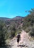
| no partners | | Tackled this one from First Water Road because of an earlier start possible, instead of waiting on Lost Dutchman Park to open. I've recently scoped the McKellips TH, but it seemed sketchy. When I left, it was 95 in Tempe, but 84 in AJ, so it didn't seem that bad. They're building a new informational sign at the first parking area where the crosscut for Jacob's Crosscut begins. On the traverse over, there were these weird birds (single white spot on each wing) chirping and lurch flying very low all around me and the dry bushes and grass were already active with lizards. The trail was empty on the ascent up Siphon Draw, in fact, I didn't see anyone else on this hike. After leaving Siphon Draw, I thought the gully ascent was quite tame by Supes bushwhack standards. You could tell a great many hikers have crashed through here, perhaps misguided Flatiron hikers. There were a few areas that could use a slight prune. The temperature at the summit of 4175 was breezy nice, plus by then a good cloud cover had established. The original goal was to just return the same route, but after downing some early liquid courage, the northern descent began to strongly draw. I peered over the edge and thought of Ms. Hogan's recent quote in AzHighways, "Oh, it goes".  I knew the Motherlode route was directly below, so all that had to be done was get to it and the rest would be easy-peasy. I hadn't worn my gaiters to the summit, but now put them on and dropped in. You basically descend directly north from Peak 4175. The dry grasses are very slippery, almost slicker than when they're green and wet. There are a few steep shelves to downclimb here and there and were a few cairns, but for the most part, one can descend and link into the Motherlode route, then the Treasure Loop to Praying Hands route back to Jacob's Trail. There were three deer on the last section of the crosscut. I headed over to finish off Silly Mountain afterwards since I was in the neighborhood. I knew the Motherlode route was directly below, so all that had to be done was get to it and the rest would be easy-peasy. I hadn't worn my gaiters to the summit, but now put them on and dropped in. You basically descend directly north from Peak 4175. The dry grasses are very slippery, almost slicker than when they're green and wet. There are a few steep shelves to downclimb here and there and were a few cairns, but for the most part, one can descend and link into the Motherlode route, then the Treasure Loop to Praying Hands route back to Jacob's Trail. There were three deer on the last section of the crosscut. I headed over to finish off Silly Mountain afterwards since I was in the neighborhood. |
| | |
|
|
|
 Route Editor


 It was good to get out! Thanks for the hike Wally! Like HAZ, you rock!