username
X
password
register
for free!
help
ArticlesGuidesRoutes
 
Photosets
 
 Comments
triplogs   photosets   labels comments more
La Barge Lowest Loop - 17 members in 33 triplogs have rated this an average 3.8 ( 1 to 5 best )
1, 2  Next
33 triplogs
login for filter options
Apr 27 2024
avatar

 Routes 1
 Photos 356
 Triplogs 31

43 male
 Joined Nov 23 2007
 Tempe, AZ
La Barge Lowest LoopPhoenix, AZ
Phoenix, AZ
Hiking avatar Apr 27 2024
bballardTriplogs 31
Hiking6.30 Miles 900 AEG
Hiking6.30 Miles
900 ft AEG
 no routes
Linked   none no linked trail guides
Partners none no partners
Including your 3-year old son and the dog on a fairly straightforward itinerary can certainly up the ante! The water was quite high this day compared to other times I've visited this canyon. There were a few swimmers and obstacle navigations that made our time very interesting! Took a shortcut out of the canyon and the trail all the way back. Otherwise a great time and memorable experience.
_____________________
 
Jan 05 2024
avatar

 Guides 59
 Routes 1,100
 Photos 1,191
 Triplogs 1,290

male
 Joined Jan 01 2023
 Arizona
Supes Walkabout, AZ 
Supes Walkabout, AZ
 
Hiking avatar Jan 05 2024
pseudalpineTriplogs 1,290
Hiking24.88 Miles 4,069 AEG
Hiking24.88 Miles   10 Hrs   40 Mns   2.46 mph
4,069 ft AEG      32 Mns Break
 
1st trip
  8 archives
Dec 17 2023
avatar

 Routes 80
 Photos 149
 Triplogs 78

male
 Joined May 23 2016
 Tempe, AZ
La Barge Lowest LoopPhoenix, AZ
Phoenix, AZ
Hiking avatar Dec 17 2023
chrisbjohnsonTriplogs 78
Hiking4.39 Miles 954 AEG
Hiking4.39 Miles   2 Hrs   58 Mns   1.63 mph
954 ft AEG      16 Mns Break
 no routes
1st trip
Linked   none no linked trail guides
Partners none no partners
At 2.88 miles hiking in from the tailhead, I couldn’t get through the end of the trail because there was a big pond. It’s about 2 to 3 feet deep water in a narrow portion of the canyon. Just before that, there was a large thick of tall grass. It’s hard to get through the grass. The way through is actually around it against the canyon wall on the east.

This trail isn't a trail, but a hike through a rocky creek bed. It is a great challenge in remote country with no one around.
_____________________
  2 archives
Feb 11 2023
avatar

 Guides 94
 Routes 840
 Photos 22,055
 Triplogs 1,993

52 male
 Joined Sep 18 2002
 Tempe, AZ
La Barcaza, AZ 
La Barcaza, AZ
 
Hiking avatar Feb 11 2023
chumleyTriplogs 1,993
Hiking15.05 Miles 2,861 AEG
Hiking15.05 Miles   7 Hrs   10 Mns   2.25 mph
2,861 ft AEG      28 Mns Break
 no routes
1st trip
This one was John's plan but I was at least reasonably intrigued as the last time I tried to do the upper loop I got flashed out by post-fire mud flow. Having never hiked out via the lower creek, I penciled that in for the day as well.

It was insanely cold and windy to start as we took 103 up the hill. Dropping down to the creek we dodged water all the way upstream to Cavalry -- save for one poor choice -- before cutting across to Boulder Canyon. Here we saw our only people on the day, a group of likely human traffickers in town for the game, though the girls did not blink twice when we prompted them to, so on we went.

We cut the corner taking the short stretch along Boulder before meeting up with La Barge again. Any attempts to stay dry ended here, but it was an absolutely great stretch of canyon, and one I'm sorry its taken so long for me to explore. I'll be back!

After a short break at the lake, we pieced together some use trails up to 103 and back to the car for the typically annoying 88 drive back to AJ. Great day!
_____________________
I'm not sure what my spirit animal is, but I'm confident it has rabies.
 
Jan 18 2019
avatar

 Routes 2
 Triplogs 5

76 male
 Joined Dec 13 2018
 Litchfield Park,
La Barge Lowest LoopPhoenix, AZ
Phoenix, AZ
Hiking avatar Jan 18 2019
Robbie38Triplogs 5
Hiking7.51 Miles 1,326 AEG
Hiking7.51 Miles   5 Hrs   14 Mns   1.63 mph
1,326 ft AEG      37 Mns Break
 
no photosets
1st trip
Linked   none no linked trail guides
Partners none no partners
Route Scout Route Recorded  on Route Scout | Pop | Map | Popup | MapDEX
My daughter, Amy, and I completed a 7.5 mi loop, starting at the Canyon Lake trailhead. We followed the La Barge Creek through Boulder Canyon to the Boulder Canyon Trail. The La Barge Creek Route is a lot of boulder hopping and therefore much slower than an established trail. There was only one spot where we had to squeeze through a slot between the canyon wall and large boulders to get around a large pool of water. We stopped for lunch at the Indian Paint Mine, before returning to the Canyon Lake trailhead via the Boulder Canyon trail. As usual, there were spectacular views of Battleship Mountain, Weavers Needle and Canyon Lake from the higher elevations on the Boulder Canyon Trail.
 
Feb 25 2018
avatar

 Photos 1,217
 Triplogs 206

68 male
 Joined Aug 04 2006
 Mesa, AZ
La Barge Lowest LoopPhoenix, AZ
Phoenix, AZ
Hiking avatar Feb 25 2018
hikemonkTriplogs 206
Hiking6.30 Miles 900 AEG
Hiking6.30 Miles
900 ft AEG12 LBS Pack
 no routes
Linked   none no linked trail guides
Partners none no partners
Had lots more photos but they had other hikers in them and I try to the greatest extent possible, to not post photos with people in them, for multiple reasons.
_____________________
 
Apr 16 2016
avatar

 Routes 189
 Photos 7,236
 Triplogs 1,740

57 male
 Joined Apr 25 2011
 Goodyear, AZ
La Barge - Battleship Saddle LoopPhoenix, AZ
Phoenix, AZ
Hiking avatar Apr 16 2016
NightstalkerTriplogs 1,740
Hiking13.40 Miles 2,678 AEG
Hiking13.40 Miles   8 Hrs   31 Mns   1.97 mph
2,678 ft AEG   1 Hour   42 Mns Break16 LBS Pack
 no routes
1st trip
Partners none no partners
Decided to follow bensondk's description from Jan 2013. Trail was easy enough to follow up until the trail split over to Boulder Canyon. Rock hopped up La Barge Canyon up to the box with some moderate route finding. The box section is spectacular! The trail up to the saddle from the campsite was easy to find and follow. Dropped down off the saddle to Boulder Creek, trail was easy to follow up to the La Barge split. We rock hopped and bushwacked for a half mile further down Boulder Creek until we found the route impassable with overgrowth and deep, dark, murky water. The sound of a rattlesnake in the tall, thick grass sealed the deal and we returned to the La Barge split and followed that trail past the old mine and returned the rest of the way we came. This choice added many additional miles and AEG! We were beat! Cold drinks and some grub at the marina were the perfect finish to a long hard hot hike!
wildflower observationwildflower observationwildflower observationwildflower observationwildflower observation
Wildflowers Observation Moderate
Plenty of cactus blooms.

water 1 out of 5water 2 out of 5water 3 out of 5water less than max Boulder Canyon Medium flow Medium flow
Deep pools!
_____________________
 
May 16 2015
avatar

 Guides 1
 Routes 447
 Photos 4,407
 Triplogs 938

68 male
 Joined Mar 09 2012
 Gilbert, AZ
Boulder Canyon Labarge Creek Loop, AZ 
Boulder Canyon Labarge Creek Loop, AZ
 
Hiking avatar May 16 2015
rayhustonTriplogs 938
Hiking10.32 Miles 2,085 AEG
Hiking10.32 Miles   5 Hrs   49 Mns   2.11 mph
2,085 ft AEG      56 Mns Break12 LBS Pack
 
1st trip
Partners none no partners
Another ridiculously cool day in May, so another hike in the Supes. Yay!

With temps projected to top out in the low 70's, there was no reason to rush. Went for a 2+ mile walk around the neighborhood with Rhonda, had breakfast, then headed out to Canyon Lake. Started the hike a few minutes after 11am. Wow, that's really late, but temps were still in the 60's.

With the exception of the initial 3 miles on the Boulder Canyon trail, most of this hike is in creek beds, fun stuff if you like boulder hopping. First time hiking in La Barge Creek. I lost the trail just before La Barge Box and had to climb over some rather large boulders before landing back on the trail. Or maybe that was the trail. Route finding skills are needed along La Barge Creek during the return to Canyon Lake. The scenery through this area is awesome. I was very happy I took this route back.

A mostly cloudy morning gave way to beautiful afternoon sunshine. Saw (and heard) one person standing on the stern of Battleship, just above the alcove, as I was crossing the saddle. He was commenting to an unseen person how nice it was "...up here." I passed a group of backpackers at Boulder/2nd Water junction, resting before heading up the hill to Garden Valley. I was mildly surprised I didn't see more people out.

Good workout hike on what turned out to be a gorgeous day after the skies cleared. Very enjoyable hike.
 Named place
 Named place [ checklist ]
[ checklist ]  Geronimo Head  Indian Paint Mine
_____________________
  2 archives
Nov 29 2014
avatar

 Routes 1
 Photos 356
 Triplogs 31

43 male
 Joined Nov 23 2007
 Tempe, AZ
La Barge Lowest LoopPhoenix, AZ
Phoenix, AZ
Hiking avatar Nov 29 2014
bballardTriplogs 31
Hiking6.00 Miles 925 AEG
Hiking6.00 Miles   6 Hrs      1.00 mph
925 ft AEG
 no routes
Linked   linked  
Partners none no partners
Another wonderful day in the Supes. Have never hiked from the Canyon Lake trailhead, so figured this loop involving the off-trail La Barge Canyon and Boulder Canyon trail would be perfect. This is very close to trip 35 of Carlson's Guide to the Superstition Wilderness- it is the longer alternate to Paint Mine direct through the canyon.

A warm day and beautiful magical moments in the creek- plenty of water and glimpses of incredible remote Superstition wilderness. There were times when the water appeared to be non-existent, but around the corner we would find large pools and small streams. Some very deep areas, but nothing was continuously connected top to bottom. Just when you think you have a path figured out to one side, it would become overgrown and blocked by water. So, very slow going through the canyon, but once we reached Boulder Canyon Trail things were much easier.

water 1 out of 5water 2 out of 5water 3 out of 5water less than max Boulder Canyon Medium flow Medium flow
Good amount of water intermittently throughout.

water 1 out of 5water 2 out of 5water 3 out of 5water less than max Boulder Creek at #103 / #236 Jct Medium flow Medium flow
Good amount of water if you hunt around for the right spot.

water 1 out of 5water 2 out of 5water 3 out of 5water less than max La Barge Creek Medium flow Medium flow
Good amount of water intermittently throughout.
_____________________
 
Nov 22 2012
avatar

 Guides 48
 Routes 510
 Photos 9,555
 Triplogs 578

79 male
 Joined Dec 28 2006
 Scottsdale, AZ
La Barge Lowest LoopPhoenix, AZ
Phoenix, AZ
Hiking avatar Nov 22 2012
GrasshopperTriplogs 578
Hiking6.90 Miles 1,721 AEG
Hiking6.90 Miles   6 Hrs      1.53 mph
1,721 ft AEG   1 Hour   30 Mns Break
 
1st trip
Linked   linked  
Partners partners
Trishness
:D Thanksgiving Day 2012 !! :D

On this unseasonably warm Turkey Day 2012, Trish and I picked this first time Western Superstition loop hike for some needed exercise to later justify consuming her planned evening dinner feast for four.

Our planned hike for this loop was per the hike description writeup with the exception of a planned return back to the Canyon Lake TH on TR#103.

We did not care at all for this lower off-trail hiking section of La Barge Creek nor this hikes lower off-trail hiking section of Boulder Canyon.. just too many large, never ending creek rocks to negotiate, too much overgrowth in some sections, and not enough scenic views. We did enjoy the views south heading north up the Boulder Canyon Trail but the very warm :sweat: afternoon uphill on this Trail #103 was a little too much for the two of us on this unseasonably warm Turkey Day 2012.
 Fauna
 Fauna [ checklist ]
[ checklist ]  Grasshopper
 Culture
 Culture [ checklist ]
[ checklist ]  HAZ Gear
 Named place
 Named place [ checklist ]
[ checklist ]  Canyon Lake  La Barge Creek
foliage observationfoliage observationfoliage observationfoliage observationfoliage observation
Autumn Foliage Observation Moderate

water 1 out of 5water less than maxwater less than maxwater less than max La Barge Creek Pools to trickle Pools to trickle
Very few water pools which were approaching stagnant status;
_____________________
(Outside.. "there is No Place Like It!!")
 
Nov 22 2012
avatar

 Guides 14
 Photos 720
 Triplogs 187

66 female
 Joined May 21 2003
 Apache Junction,
La Barge Lowest LoopPhoenix, AZ
Phoenix, AZ
Hiking avatar Nov 22 2012
TrishnessTriplogs 187
Hiking6.90 Miles 1,500 AEG
Hiking6.90 Miles   6 Hrs      1.31 mph
1,500 ft AEG      45 Mns Break
 no routesno photosets
1st trip
Linked   none no linked trail guides
Partners partners
Grasshopper
Did Navig8tor's Lowest Labarge Loop with return on Boulder Canyon #103

As Fritski's title said, "Do it just to say you did it". This is my first time doing this hike in Lower Labarge. Headed out from Canyon Lake TH this Thanksgiving morning after telling my family we would be back by 3-3:30. Located the spur trail and headed down into the canyon. Let the bouldering begin! The canyon was rather pretty with some pools of water here and there....nothing much else to comment about here. At first it was fun but after the first mile I realized that bouldering is not high on my list of "fun things" to do. Some of the boulders were difficult to maneuver on/over due to my short legs and there was one particular section that was really tough for me to navigate. Thankfully Hank lent me a hand getting by this. :thanx: It was very slow moving for me through the boulders and I managed to torque my ankle numerous times, fell once and got pinned by a cholla. We finally got to the intersection of Boulder Canyon trail and I was already exhausted but elated that we were on a trail! I looked at hanks and said "WHO picked this hike?" Oh yeah, it was me. :--: Let me mention that it was unseasonably warm today with temps in the 80's. We took off up Boulder Canyon Trail and started hiking out. This was such an off day for me and I could barely hike a quarter mile and had to stop. I was sweating profusely, drinking tons of water but not feeling hydrated, had a racing heartbeat and felt weak and lightheaded. I knew I was experiencing signs of dehydration and the beginnings of heat exhaustion which kind of scared me. :--: We finally topped off and could see Canyon Lake knowing that it was all downhill and a short distance left. Hank was terrific as I was clearly having problems and told me "do what you need to do and go the speed you can go". We saw 4 people heading out in the AM and two people on the trail all day. We were over an hour late getting out. Probably bit off a bit more today than we should have.

Would I do this trail again? Probably not......bouldering is really not my forte. But I did it once!

As soon as we got to the parking lot I turned the AC on in the X and immediately started feeling better. We were a hour and a half later than expected so dinner was going to be late OH WELL! Drove back to AJ and enjoyed a sumptuous feast! Turkey, stuffing, mashies and all the good things that go with Thanksgiving.
_____________________
Trish-Kabob

"May your trails be crooked, winding, lonesome, dangerous, leading to the most amazing view. May your mountains rise into and above the clouds" Ed Abbey
 
Jan 23 2012
avatar

 Guides 4
 Photos 542
 Triplogs 573

46 male
 Joined Oct 19 2010
 Mesa, AZ
La Barge Lowest LoopPhoenix, AZ
Phoenix, AZ
Hiking avatar Jan 23 2012
Charger55Triplogs 573
Hiking7.40 Miles 925 AEG
Hiking7.40 Miles   3 Hrs   10 Mns   2.34 mph
925 ft AEG
 no routesno photosets
Linked   linked  
Partners none no partners
Three weeks ago I did LaBarge as an out and back. I came back today to complete the loop. There wasn't nearly as much water in the creek this time around.
_____________________
"I've driven across deserts, driven by the irony, that only being shackled to the road could ever I be free"
- Frank Turner "The Road"
 
Jan 03 2012
avatar

 Guides 4
 Photos 542
 Triplogs 573

46 male
 Joined Oct 19 2010
 Mesa, AZ
La Barge Lowest LoopPhoenix, AZ
Phoenix, AZ
Hiking avatar Jan 03 2012
Charger55Triplogs 573
Hiking6.20 Miles 925 AEG
Hiking6.20 Miles   3 Hrs      2.07 mph
925 ft AEG
 no routesno photosets
Linked   none no linked trail guides
Partners none no partners
Impromptu trip! I wanted to hike past Tortilla Flat but Tortilla Creek was flowing across the Trail. In a high clearance vehicle I wouldn't have thought twice. In my midget car I was a little reluctant. So I turned around and went back to the marina. Without any route info I did this as an out and back to just past the point where Battleship Mountain comes into view. I see now I wasn't far from where Boulder Canyon Trail connects with LaBarge Canyon. I may come back next week and complete the loop.
_____________________
"I've driven across deserts, driven by the irony, that only being shackled to the road could ever I be free"
- Frank Turner "The Road"
 
Dec 31 2011
avatar

 Guides 1
 Photos 484
 Triplogs 64

58 female
 Joined May 27 2006
 Apache Junction,
La Barge Lowest LoopPhoenix, AZ
Phoenix, AZ
Hiking avatar Dec 31 2011
DanaLee67Triplogs 64
Hiking3.11 Miles 925 AEG
Hiking3.11 Miles   1 Hour   50 Mns   1.70 mph
925 ft AEG
 no routes
1st trip
Linked   none no linked trail guides
Partners none no partners
Did an out and back into the canyon with my friend. Would have done the 6 mile loop but someone kept mentioning that we had to make our way back out of the canyon and that she is older than me...out of shape...blah blah blah...not mentioning any names though! :)

Just in over a mile and a half and enjoyed it thoroughly! It is such a beautiful canyon! Used one of the GPS route downloads but don't know if it was really necessary. If you don't pass the spur trail that leads down into the canyon, then you have it made! Okay, I admit..I passed it and had to go back down to it! But I found it! I thought it was further up by where you hook it left on the main trail. My bad!

Not a soul in site....until we were about out of the canyon. Just the way I like it :)
_____________________
 
Dec 10 2011
avatar

 Routes 85
 Photos 3,718
 Triplogs 486

female
 Joined Oct 15 2002
 Rimrock, Arizona
La Barge Lowest LoopPhoenix, AZ
Phoenix, AZ
Hiking avatar Dec 10 2011
cactuscatTriplogs 486
Hiking6.00 Miles 925 AEG
Hiking6.00 Miles
925 ft AEG
 no routesno photosets
1st trip
Linked   none no linked trail guides
Partners none no partners
foliage observationfoliage observationfoliage observationfoliage observationfoliage observation
Autumn Foliage Observation Substantial
_____________________
 
Nov 21 2011
avatar

 Guides 1
 Routes 38
 Photos 3,193
 Triplogs 467

55 male
 Joined Jul 26 2008
 San Tan Valley,
La Barge Lowest LoopPhoenix, AZ
Phoenix, AZ
Hiking avatar Nov 21 2011
TheNaviG8RTriplogs 467
Hiking7.40 Miles 1,503 AEG
Hiking7.40 Miles
1,503 ft AEG
 
1st trip
Linked   none no linked trail guides
Partners none no partners
What a great Morning to get out and stretch the legs. This is a great hike and a must do.
 Flora
 Flora [ checklist ]
[ checklist ]  Cattails  Saguaro
 Named place
 Named place [ checklist ]
[ checklist ]  Canyon Lake
_____________________
  1 archive
Nov 20 2011
avatar

 Routes 69
 Photos 3,135
 Triplogs 1,853

72 male
 Joined Jul 24 2009
 Mesa, AZ
La Barge Lowest LoopPhoenix, AZ
Phoenix, AZ
Hiking avatar Nov 20 2011
trailzrusTriplogs 1,853
Hiking7.19 Miles 925 AEG
Hiking7.19 Miles
925 ft AEG
 no routes
1st trip
Linked   none no linked trail guides
Partners none no partners
 Named place
 Named place [ checklist ]
[ checklist ]  Canyon Lake
_____________________
 
Feb 21 2011
avatar

 Guides 7
 Routes 19
 Photos 3,021
 Triplogs 191

67 male
 Joined Jun 01 2010
 Mesa, AZ
La Barge Lowest LoopPhoenix, AZ
Phoenix, AZ
Hiking avatar Feb 21 2011
paulhubbardTriplogs 191
Hiking6.00 Miles 925 AEG
Hiking6.00 Miles   4 Hrs      1.50 mph
925 ft AEG
 no routes
1st trip
Linked   none no linked trail guides
Partners partners
kplumaz
Saw this loop and it looked fun for a dayhike. It was fun, albeit a lot of rock-hopping! Wear your stiff soled shoes for this one! Keeping this one in the queue for springtime when it's nice and green.
 Culture
 Culture [ checklist ]
[ checklist ]  Throwing a Wendy
_____________________
Good judgement comes from experience. Experience comes from bad judgement.
 
Feb 20 2011
avatar

 Guides 3
 Routes 4
 Photos 8,687
 Triplogs 931

46 male
 Joined Mar 28 2005
 Gilbert, AZ
Battleship Mountain - SuperstitionsPhoenix, AZ
Phoenix, AZ
Canyoneering avatar Feb 20 2011
VapormanTriplogs 931
Canyoneering11.40 Miles 2,200 AEG
Canyoneering11.40 Miles   7 Hrs   15 Mns   1.57 mph
2,200 ft AEG
Canyon Hiking - Non-technical; no rope; easy scrambling; occasional hand use
A - Dry or little water; shallow or avoidable water; no wet/dry suit
III - Normally requires most of a day
 no routes
Partners none no partners
So I've always had my own version of Battleship by doing some variation of a figure 8 loop from the Boulder Canyon trail, hit Battleship, drop down and hit La Barge Box, and then back out via the trail or the canyon. Oddly enough today's loop came out to about 11+ mile also... :sweat:

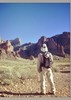
The wet Supes is one of my fav wilderness smells and I definelty wan't going to miss out on that during another of our few winter storms (Thanksgiving, New Years, and now President's Day weekend) this season. :D I started from Boulder Canyon on that overcast morning with rain jacket in my pack and was braking it out a couple miles in when the first wave of rain hit. The rain broke and it was clear by the junction with second water trail, so I continued up Boulder Canyon and decided to make a run on Battleship. The rock was a little wet but not too bad and it also helps that exposure doesn't affect me much though the wind didn't help while balancing across those narrows saddles. I got to the summit of Battleship but wasn't able to stay long due to spotting another wall of rain over Canyon Lake and headed my way fast. :o I got about 2/3 back along the spine when it started to hail & heavy rain, so I sought shelter for a few minutes along a cliff face while I let the worse of it pass while putting on my rain jacket. Dropped off of the bow and headed for the saddle and then down the northside to the Box. La Barge wasn't flowing at all except at the Box, so I decided to forgo my usual running up the Calvary trail and dropping in up there and just dropped in right at the Box. ;) La Barge Box was as sweet as ever and definitely much calmer than when I visited it last winter during a huge flood... So I'm not the only one crazy enough to hike in the middle of a rainstorm with seeing two backpackers up on the Battleship and another two entering the Box while I was exiting. :) La Barge is much easier to travel when it's not flowing despite all the wet rocks, so I decided to follow the canyon downstream instead of taking the trail back since I hadn't done this variation last winter due to the crazy flow. The confluence of La Barge & Boulder Canyon is always a sweet one with big trees in the 'narrows', towering Rhyolite walls, and cool pools to bypass despite all the rain & wet rock hopping. :GB: Soon enough I reached the lake (too bad I didn't have my packraft ;)) and took the use trail back up to the main trail. Hmm, looks like the storm broke and it turned into a beautiful sunny afternoon with loads of puffy clouds. :DANCE:
_____________________
Yea, canyoneering is an extreme sport... EXTREMELY dramatic!!! =p
 
Feb 07 2011
avatar

 Routes 28
 Photos 1,221
 Triplogs 27

71 male
 Joined Jan 14 2009
 Kodiak, AK
Marsh Valley LoopPhoenix, AZ
Phoenix, AZ
Backpack avatar Feb 07 2011
mr_squishyTriplogs 27
Backpack28.00 Miles 3,540 AEG
Backpack28.00 Miles3 Days         
3,540 ft AEG
 no routes
1st trip
I hiked in from the Canyon Lake TH on the Boulder Canyon Trail 103; when it crosses LaBarge Creek, I turned left and followed LaBarge all the way to its intersection with Marsh Valley. It was my first time through the Box and it was magnificent!! I saw two frogs among other critters in the Box. I also saw two hikers up on the summit of Battleship Mtn. Bravo! LaBarge after the Box involves a bit of bushwacking until you reach Cavalry.
I camped in the Marsh Valley area, Monday and Tuesday nights, finding small pools of water.
Tuesday, I day hiked up to Black Mtn via Cavalry to Lost Dutchman to Peter's trails, out and back. I saw a white tail deer in the Black Mtn area.
Wednesday, I returned via Cavalry Tr to Boulder Canyon TR to LaBarge Creek, then back to Boulder Canyon Tr for last little bit. Someone had flagged the connector trail from LaBarge back up to the Boulder Canyon Trail with orange surveyor tape.
A superb trip and beautiful country.
Water: isolated pools in lower LaBarge, running in the Box, isolated pools in upper LaBarge, plenty near Charlebois Spring, small pool on Peter's Mesa where trail crossed a small drainage just before it drops down to Lost Dutchman Tr.
_____________________
Posted from my turquoise Princess rotary dial phone.
 
average hiking speed 1.79 mph
1, 2  Next

WARNING! Hiking and outdoor related sports can be dangerous. Be responsible and prepare for the trip. Study the area you are entering and plan accordingly. Dress for the current and unexpected weather changes. Take plenty of water. Never go alone. Make an itinerary with your plan(s), route(s), destination(s) and expected return time. Give your itinerary to trusted family and/or friends.

helpcommentissue

end of page marker