|
| | | Snoopy & Airport Loops Sedona, AZ | | | |
|
|
Snoopy & Airport Loops Sedona, AZ
| | |
| |
|
| Hiking | 11.70 Miles |
1,900 AEG |
| | Hiking | 11.70 Miles | | | |
| 1,900 ft AEG | | | | |
|
|
| |
| Partners |
|
[ show ]
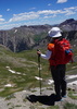
| partners | | angela found a route posted by @pbaenzig from years ago that made a loop off margs draw trail, going along the south side of the snoopy rock formation
we thought we could combine that loop with airport loop for a decent scenic day in sedona
got going around 0900 just as parking was filling up at munds wagon trailhead
took margs draw to the end, then found our use trail on the way back
this segment was quite overgrown with sticker bushes for a good half mile
we also got off trail crossing a wash, resulting in a blair witch circle 
eventually we came to a nice flat bedrock area, similar to the cow pies trail bench
quick snack break at the east end of it, then headed west along the base of the rock formations
much of the trail was on nice red rock and reminded us of the hangover trail
we saw some guys up on a high bench and then found another use trail that switchbacked up to it
the trail continued to a saddle above that offered fantastic views of chimney rock, thunder mountain and wilson mountain
we dropped down and linked up with margs draw to finish the loop
great views the entire hike
would recommend a simple out and back on the most scenic parts [ gps route ]
can't think of any reason to do the lower leg of the loop
never did see the snoopy resemblance until angela texted me a photo sunday night
took an appetizer break at the olde sedona bar & grill
drove over to airport mesa
no parking below, so paid $3 to park at the overlook, adding a half mile each way to airport loop
this included a nice climb back out at the end 
went to the overlook points first, then clockwise on the loop
nice views to the southeast of cathedral rock, courthouse butte and bell rock, along with oak creek
angela knew i wanted to hit table top, so she generously waited for me while i did the out and back
the west side isn't as scenic, but we had a good breeze and eventual views of doe, bear, chimney rock, thunder and wilson mountains as we circled back to the start
i had done this hike a few years ago, and enjoyed seeing it again
airport mesa is an interesting high point
we saw a few small planes taking off, some of them pretty close
finished uphill then set off for the valley, making good time without much traffic
always a good day in tibber mode; it had been awhile since our last hike and we both like sedona
thanks for driving, angela
we even hit double digits for the day  |
| _____________________
| | |
|
|
|
 Route Editor


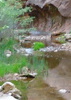


 Headed out below Snoopy on the Marg's Draw Trail walking south. I was pretty impressed by the artistic metalwork on the trail sign. The trail is a typical rolling Sedona hike with agaves, junipers, pinons, prickly pear, the works. There was a trickle of water flowing off a waterfall along the trail, in what I assume is Marg's Draw proper. The trail is close to the city, so noise pollution was radiating into my ears for three quarters of Marg's Draw. Views to the west of all the Sedona landmarks were decent, but much of the city was also in view. About halfway down Marg's Draw Trail, there's a junction to a smaller trailhead back in a neighborhood, or a small social trail that heads up toward Mund's Mountain...and it looks tempting. Some other day. About this point the views to Mund's are very open and welcome.