username
X
password
register
for free!
help
ArticlesGuidesRoutes
 
Photosets
 
 Comments
triplogs   photosets   labels comments more
Massacre Falls - 92 members in 377 triplogs have rated this an average 3.4 ( 1 to 5 best )
1, 2, 3, 4, 5 ... 19  Next
377 triplogs
login for filter options
Feb 15 2025
avatar

 Routes 44
 Photos 2,133
 Triplogs 82

female
 Joined Dec 09 2024
 
Massacre and Canyon of the Waterfalls loop, AZ 
Massacre and Canyon of the Waterfalls loop, AZ
 
Hiking avatar Feb 15 2025
DesertNymphTriplogs 82
Hiking7.97 Miles 1,981 AEG
Hiking7.97 Miles   5 Hrs   20 Mns   1.66 mph
1,981 ft AEG      32 Mns Break
 
1st trip
Partners none no partners
Wanted to get out and check see if there was any evidence of recent rains that had been advertised in the weather forecasts. Sadly, it seems like the forecasts were overly optimistic early in the week and by the end of the week, most of the rain fizzled.

The trails definitely looked like they had been rained on (they bore speckled patterns from landing raindrops) but by the early morning when I got started, the trails were completely dry.

Knowing that I was planning on hitting some extremely popular trails, I aimed for a 7am start out of the trailhead. On arrival, there were only a handful of cars and I saw one couple with their pup hit the trail ahead of me while I was pulling my things together. What a difference day of the week makes...heading up trail, I could hear the dull roar of traffic on 88 interspersed with the much more pleasant sounds of cactus wren and quail.

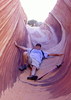
The Massacre Falls trail is a veritable highway, showing significant wear and erosion, likely due to its popularity with the hordes in addition to equestrian traffic. Encountered numerous folk hiking out as I was hiking up, lapped one couple, and got lapped by one couple. There really wasn't any evidence of any rain found aside from the water droplet pits on the trail surface obscuring footprints from visitors prior to the rain falling. After checking out the falls, I headed back down the trail, looking for a use path and cairn that would get me on the cutover trail towards Canyon of the Waterfalls / the Praying Hands loop. The use path I hopped on turned out to be a dud, disappearing into the tall grasses - I realized should have stayed on the Massacre Falls trail a bit longer before cutting over as I found myself on top of a cliff band. It was easy enough to walk cross country to eventually meet up with the fairly well established use trail to cut over towards Canyon of the Waterfalls / Praying Hands loop.

Once I regained established trails, weekend hiker traffic became more evident, with numerous other hikers spotted. The hike up to Canyon of the Waterfalls (the waterfall at in Weekes Wash) was appreciably easier for me compared to the first time I hiked it back in November when I was just getting back into hiking - was nice to actually feel a difference in my ability, though I'm still ridiculously slow on inclines 😆 ah well, it's not a race. Managed to check out the dryfall area quickly before others who had been yelling up canyon arrived. The pool at the base of the falls has been replenished by the recent rainfalls, but I anticipate it won't last long as the weather heats up.

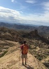
On a whim, I decided to widen my return route, and headed towards praying hands, where a climbing group had been working on summiting - when I was heading up towards Canyon of the Waterfalls, they were at approximately the equivalent to the first knuckle on the index finger, and by the time I hit praying hands, they had summited and at least one climber was rapelling down. Praying hands marked the beginning of the absolutely bonkers weekend hiking traffic complete with train horns and booms from the Goldfield Ghost Town down the way on 88. I had forgotten how horribly braided the trail is and was glad to break free of the bulk of the weekend visitor traffic once I hit the crosscut turnoff.

Wildlife: a few lizards, a ground squirrel (too fast for me to identify), cactus wren, quail, and various other birbs.

It was nice to get out in the morning for a quick-ish hike, though I'll have to check my sanity next time I decide to do a popular trail during the weekend! 😆
 Flora
 Flora [ checklist ]
[ checklist ]  Ocotillo
wildflower observationwildflower observationwildflower observationwildflower observationwildflower observation
Wildflowers Observation Isolated
Some ocotillo are putting out blooms (no leaves though!)

water 1 out of 5water less than maxwater less than maxwater less than max First Water Creek Falls Pools to trickle Pools to trickle
Pool at the bottom of the falls replenished by recent rain, no flow observed.


_____________________
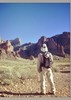
Happier when hiking....I may not move fast (and I'm often distracted by wildflowers), but I'll get there eventually 😆
  3 archives
Mar 30 2024
avatar

 Routes 9
 Photos 490
 Triplogs 20

female
 Joined May 20 2016
 AZ
Massacre FallsPhoenix, AZ
Phoenix, AZ
Hiking avatar Mar 30 2024
WildForAZTriplogs 20
Hiking6.79 Miles 1,874 AEG
Hiking6.79 Miles   5 Hrs   45 Mns   1.18 mph
1,874 ft AEG
 no routes
1st trip
Linked   none no linked trail guides
Partners none no partners
Went out for a hike in the Superstitions. I thought I might be in trouble getting a parking spot at the Crosscut TH on a Saturday at 10:30am, but I lucked out when two different spots were available. A lot of people were doing this hike.

There was a very nice breeze that got stronger as the day went on. The falls were trickling, and you could hear it hitting the ground from a couple hundred feet away. After visiting the falls, I went off trail around Massacre Grounds to explore some of the small caves around there. The views of the Superstition Wilderness from this area are amazing.
 Geology
 Geology [ checklist ]
[ checklist ]  Natural Arch  Tafoni
wildflower observationwildflower observationwildflower observationwildflower observationwildflower observation
Wildflowers Observation Moderate
Brittlebush, Rock Echeveria, Phacelia, Desert Phlox, Blackfoot Daisy, Senna, Nightshade, Texas Betony
_____________________
 
Feb 09 2024
avatar

 Guides 69
 Routes 37
 Photos 3,010
 Triplogs 2,387

55 male
 Joined Oct 24 2010
 Phoenix,Az
Massacre FallsPhoenix, AZ
Phoenix, AZ
Hiking avatar Feb 09 2024
mt98dewTriplogs 2,387
Hiking7.90 Miles 2,096 AEG
Hiking7.90 Miles   4 Hrs   6 Mns   1.93 mph
2,096 ft AEG
 no routes
Linked   none no linked trail guides
Partners none no partners
First hike of the day. With all the weather we’ve had over the last several days I felt it was a great time to visit the “falls”. Driving out to the Supes I was thinking primarily of Canyon of Waterfalls, but it turned into a multiple “falls” hike. I’ve been to the “Canyon” several times and I am amazed that I can’t find this hike in HAZ. Am I missing it? Is it described under some other hike? My intent today was two fold : to take notes about this hike so I could add it to the HAZ data base on the off chance that it needs to be added. And also, to explore a use trail that I had bypassed several times.

Got to the Massacre Falls TH around 6:30. Fourth car in the lot. :) I was pleasantly surprised at how nice the road was to the TH. The days of rain hadn’t hurt it at all. I was also surprised at all the beat up campers, cars and debris that line SR 88 and the surrounding area. The closure of the Goldfield area seems to have caused a migration. :(

From the TH head toward Jacob’s Crosscut. Instead of making a right (west) on Jacob’s Crosscut, turn east. This well defined trail will quickly turn south and merge into an even larger trail. Initially, this trail is very wide (5 ft) and rises gradually, but around 1.1 mile it will pass fencing remnants. At this point the trail narrows considerably with surrounding brush hemming the trail. It also does quite a bit of twisting as it weaves through the surrounding foliage. At around 1.6 miles the trail reaches the base of a large rock formation. The climb up this rock formation isn’t obvious, because of the rockiness. The trail starts on the eastern edge and works its way up in a westward direction, before switchbacking. There are patches of dirt along the way that will help illuminate the trail. The trail is climbing up between two large pillars. The goal is to end up on the backside of the pillar to the east. From here the trail cuts to the west side of the ridge. In a few tenths of a mile be looking for a trail that cuts back (east) up the slope. This will bring you to another ridge. If the rains have been decent, you will start to hear the sound of flowing water.

Follow the trail southeast as it drops down into a wash. You need to go up the wash about 20 yards to find where the trails crosses to the other side. There are a couple of rocks on top of a large boulder to identify where the trail exits. The brush is high and thick at this point, but the trail is obvious and exits quickly back into the wash. To your south and west there will be a 15 ft ledge which may have some small seasonal falls. Go right a few yards to the west to climb a steep slope to the next shelf. The trail will continue south and do a steep climb up the western bank. At about 2.4 miles you will reach a large rock outcropping. The falls are just around this outcropping. The shelf around this outcropping is small, so some rock hugging is required. (The drop off is only about 6 feet so there are other ways to handle this section). At 2.5 you have reached the falls! :D Today was well worth it. Water was flowing down sections of walls that I hadn’t seen before. Shared the falls with one woman, before heading back. Within the first half mile passed 19 people heading in!

My second goal of the day was to follow a user path that I passed several times over the years. I retraced my steps to the bottom of the above mentioned rock formation. There is a large cairn located at the base. From this cairn there is a trail that heads off to the east. The trail is fairly obvious until it crosses a wash. At the wash you need to go down stream about 10 yards to pick up the trail exiting to the east. The trail became much fainter on this wash, but it is cairned and had just enough activity that I was able to follow it as it continued east. The trail went for about .8 miles before connecting to the Massacre Falls Trail. I believe I had to hike another .6 miles to reach the falls. Checked out the falls and the view from the escarpment. Returned via the Massacre Falls Trail.

This was only my second time visiting Massacre. This fall is definitely more powerful and dramatic than Canyon of Waterfalls, but there is something to be said about the tiered aspect of the “Canyon”. The crowds definitely seem to prefer Massacre. I didn’t bother counting, but it was well over 70. No wildlife. Great weather!! The Supes and Four Peaks (and beyond) were gorgeous with dustings of snow highlighting their rugged features. The trails were in amazing shape. Going in at 7am the cold temperatures made for solid footing. I was surprised to find that ice was an issue on the Massacre Trail. I had one little slip, but no fall. The trails were a little muddy on the return trip, but easy to avoid. Parking lot was a madhouse when I got back to my car at 11am. People were lining up waiting for parking and the dirt road out was lined with cars. It’s good to be early. :D

If anyone know a better place to post my Canyon of Waterfalls hike please let me know. I would love to get this posted under the right description.
_____________________
  1 archive
Jan 21 2024
avatar

 Guides 5
 Routes 27
 Photos 189
 Triplogs 26

70 male
 Joined Dec 06 2002
 Phoenix, AZ
Massacre FallsPhoenix, AZ
Phoenix, AZ
Hiking avatar Jan 21 2024
MoovyoazTriplogs 26
Hiking1.50 Miles 620 AEG
Hiking1.50 Miles
620 ft AEG
 no routes
1st trip
Linked   none no linked trail guides
Partners none no partners
I've hiked a lot in the Superstitions, but never to Massacre Falls. The forecast was 80% chance of rain, but I took the gamble anyway. Glad I did; there was only a slight drizzle which made the trail sparkle, with low clouds over the mountain. Not enough for the falls though. Never complain about rain in the desert!
_____________________
A drunkard's dream if I ever did see one
 
Jun 28 2023
avatar

 Guides 59
 Routes 1,100
 Photos 1,191
 Triplogs 1,290

male
 Joined Jan 01 2023
 Arizona
Massacre Falls Loop - First Water THPhoenix, AZ
Phoenix, AZ
Hiking avatar Jun 28 2023
pseudalpineTriplogs 1,290
Hiking10.13 Miles 1,697 AEG
Hiking10.13 Miles   3 Hrs   52 Mns   2.84 mph
1,697 ft AEG      18 Mns Break
 
1st trip
Route Scout Route Recorded  on Route Scout | Pop | Map | Popup | MapDEX
Ten by nine. The ridges were warm, the valleys cool and then it just got hot. As for bushwackiness, this route was relatively low-key by Supes standards. I've definitely done scratchier hikes within this wilderness. The official route was somewhat weird, but good enough to suggest the general way. Leaving Dutchman, we mostly stayed in the wash at first, which seemed much easier than 'literally' following the wacky black-dashed line. Also added on AZLumberjack's Peak 2891 Saddle for poos and giggles. : wink : Not too shabby.
  7 archives
Mar 17 2023
avatar

 Guides 177
 Routes 249
 Photos 10,213
 Triplogs 2,215

74 male
 Joined Feb 12 2002
 Gold Canyon, AZ
Massacre FallsPhoenix, AZ
Phoenix, AZ
Hiking avatar Mar 17 2023
AZLOT69Triplogs 2,215
Hiking6.10 Miles 1,297 AEG
Hiking6.10 Miles
1,297 ft AEG
 no routesno photosets
Linked   none no linked trail guides
Partners none no partners
Water flowing, trails crowded, fun day with brother!
_____________________
It's best for a man to remain silent and be thought a fool, than to open his mouth and remove all doubt.
--Mark Twain
 
Mar 16 2023
avatar

 Routes 386
 Photos 49
 Triplogs 792

43 female
 Joined Jun 23 2015
 Phoenix, AZ
Massacre FallsPhoenix, AZ
Phoenix, AZ
Hiking avatar Mar 16 2023
emilystardustTriplogs 792
Hiking5.67 Miles 1,271 AEG
Hiking5.67 Miles   2 Hrs   56 Mns   2.18 mph
1,271 ft AEG      20 Mns Break
 
no photosets
Linked   none no linked trail guides
Partners none no partners
Route Scout Route Recorded  on Route Scout | Pop | Map | Popup | MapDEX
_____________________
 
Feb 26 2023
avatar

 Guides 1
 Routes 148
 Photos 9,928
 Triplogs 3,655

63 male
 Joined Apr 02 2005
 Mesa, AZ
Massacre FallsPhoenix, AZ
Phoenix, AZ
Hiking avatar Feb 26 2023
Tortoise_HikerTriplogs 3,655
Hiking4.70 Miles 979 AEG
Hiking4.70 Miles   2 Hrs   51 Mns   1.65 mph
979 ft AEG
 no routes
Linked   none no linked trail guides
Partners partners
wallyfrack
Wally and I started from this trailhead and were the last truck in the first row. Surprising for the weather. Late start as the rain was supposed to be done around 10:00am.
A little wet out there but the rain had stopped.
Let the exploring begin! The brush didn’t get us as wet as we thought so we pushed on with just a scratch here and there. It did hail on us a time or two but the exploring was rewarding and the views were awesome! It did start to drizzle for the last 10 minutes of our hike. The dirt road out was getting a little slippery and we had a five minute downpour around Apache. Great views, wandering, and company! Thanks Wally. Like HAZ, you rock!
_____________________
Tortoise Hiking. Stop and smell the Petrichor.
  1 archive
Feb 26 2023
avatar

 Routes 93
 Photos 7,758
 Triplogs 1,694

64 male
 Joined Mar 11 2003
 AZ
Massacre FallsPhoenix, AZ
Phoenix, AZ
Hiking avatar Feb 26 2023
wallyfrackTriplogs 1,694
Hiking4.70 Miles 979 AEG
Hiking4.70 Miles   2 Hrs   51 Mns   1.65 mph
979 ft AEG
 no routes
Linked   none no linked trail guides
Partners partners
Tortoise_Hiker
A hike with the turtle to look for a cabin ruin. We used massacre trail but that wasn't the best route. The breeze was blowing early on and we did get some hail but the conditions were nice. The off trail was more than expected but the brush wasn't as wet as we thought it may be. Denny pressed on an eventually we found the site. The hike out was mostly trail and about half the distance. We stopped off for chili dogs afterwards.
_____________________
 
Feb 20 2023
avatar

 Guides 2
 Routes 6
 Photos 105
 Triplogs 23

47 male
 Joined Dec 11 2003
 Phoenix, AZ
Massacre FallsPhoenix, AZ
Phoenix, AZ
Hiking avatar Feb 20 2023
ChapmanTriplogs 23
Hiking5.50 Miles 1,187 AEG
Hiking5.50 Miles
1,187 ft AEG
 no routes
1st trip
Linked   none no linked trail guides
Partners none no partners
Enjoyed a good hike on Presidents’ Day with my son Zane. The falls were flowing enough to cool off and relax with few people around . Last time I did this hike was over 20 years ago with Preston Sands!
_____________________
 
Jan 23 2023
avatar

 Guides 59
 Routes 1,100
 Photos 1,191
 Triplogs 1,290

male
 Joined Jan 01 2023
 Arizona
Reverse FlatironPhoenix, AZ
Phoenix, AZ
Hiking avatar Jan 23 2023
pseudalpineTriplogs 1,290
Hiking9.02 Miles 3,651 AEG
Hiking9.02 Miles   4 Hrs   22 Mns   2.10 mph
3,651 ft AEG      4 Mns Break
 
1st trip
Completed the Reverse Flatiron in reverse, so essentially a forward Flatiron. :-k
Because everyone who loves the desert, should occasionally just wander around in it.
 Fauna
 Fauna [ checklist ]
[ checklist ]  Cardinal
  8 archives
Jan 22 2023
avatar

 Guides 2
 Routes 208
 Photos 93
 Triplogs 205

male
 Joined Aug 08 2020
 Phx az
Massacre FallsPhoenix, AZ
Phoenix, AZ
Hiking avatar Jan 22 2023
ScaredyCatTriplogs 205
Hiking9.84 Miles 1,889 AEG
Hiking9.84 Miles   4 Hrs   59 Mns   2.28 mph
1,889 ft AEG      40 Mns Break
 
no photosets
1st trip
Partners none no partners
Route Scout Route Recorded  on Route Scout | Pop | Map | Popup | MapDEX
With the recent rain in the Supes, decided to post Massacre Falls+ to Meetup. People came out for this 1. Trying to keep group together as they wish to proceed at varying speeds.

Were pleased to find a small waterfall flowing at the end of this trail. Most then bolted upon arriving back to the TH. One person proceeded with me for the second phase. Thrilled to show the beauty of the Supes to others.
 
Nov 19 2022
avatar

 Guides 27
 Routes 670
 Photos 12,111
 Triplogs 857

56 male
 Joined Jul 05 2006
 Mesa, AZ
Massacre FallsPhoenix, AZ
Phoenix, AZ
Hiking avatar Nov 19 2022
DarthStillerTriplogs 857
Hiking8.91 Miles 1,348 AEG
Hiking8.91 Miles   4 Hrs   34 Mns   1.95 mph
1,348 ft AEG
 
Linked   none no linked trail guides
Partners none no partners
I kind of made this hike up as I went along. There's a horse trail from the Massacre Grounds trail that heads over to First Water. I hiked that and then had the idea to do a loop hiking up to the cliff and then make my way over to the trails in Lost Dutchman Park. On my way back from First Water I heard some gunshots and at one point noticed a hunter in blaze orange. Glad I had my bright yellow on to be visible. Fortunately didn't have any close calls, but I was also glad I didn't see any deer near me.

After the trip to First Water, I made it up to the cliff and then found where I had hiked over from the LDSP in Jan. 2021. It's a cairned route. I remember it as being a kind of a rough trail, but today it seemed like a pretty rough tread over rocks. The cairns are still there, but no discernable trail of any sort. Already nearing the 7 mile mark, I decided to just hike back down the main trail and call it a day.

Very cool and breezy weather throughout. Lots of gusty winds at the cliff, making peering over the edge a little dicier than usual.
_____________________
 
Feb 13 2022
avatar

 Guides 2
 Routes 127
 Photos 1,478
 Triplogs 129

male
 Joined May 07 2019
 Tempe, AZ
Reverse FlatironPhoenix, AZ
Phoenix, AZ
Hiking avatar Feb 13 2022
mikemcgTriplogs 129
Hiking9.20 Miles 3,376 AEG
Hiking9.20 Miles   5 Hrs   35 Mns   1.76 mph
3,376 ft AEG      21 Mns Break
 no routes
1st trip
Did my first Reverse Flatiron on my birthday. After celebrating the night before, we started around 0800. Weather was a little chilly but sun felt good. Went off trail a couple times to explore a cave and some interesting rocks. The ascent was more straightforward than expected; the cairns were helpful to keep us on route. It was also really green with some wildflowers and a lot of great views. I should have taken more pictures. We stopped on Peak 5024 to check out the views, then headed down. We stopped at the plane crash site (first time) to pay our respects, which felt like the most precarious part of the day with all the slippery loose rocks. We then headed down the Siphon draw trail. As usual, going down was slower than going up. The last couple miles back to the trailhead were nice, pleasant, sunny, and warm. We encountered no people until the plane crash memorial, then probably 100 on the descent. Overall a great experience, much more picturesque than I expected.
 Named place
 Named place [ checklist ]
[ checklist ]  The Flatiron
wildflower observationwildflower observationwildflower observationwildflower observationwildflower observation
Wildflowers Observation Light
  4 archives
Feb 04 2022
avatar

 Photos 1,217
 Triplogs 206

68 male
 Joined Aug 04 2006
 Mesa, AZ
Massacre FallsPhoenix, AZ
Phoenix, AZ
Hiking avatar Feb 04 2022
hikemonkTriplogs 206
Hiking5.50 Miles 1,187 AEG
Hiking5.50 Miles
1,187 ft AEG30 LBS Pack
 no routes
Linked   none no linked trail guides
Partners none no partners
Starting to add pack weight in preparation of a GC backpacking trip mid-March.
_____________________
 
Dec 31 2021
avatar

 Guides 7
 Routes 187
 Photos 2,318
 Triplogs 909

74 male
 Joined Dec 10 2016
 Gold Canyon
Massacre FallsPhoenix, AZ
Phoenix, AZ
Hiking avatar Dec 31 2021
DaytripperTriplogs 909
Hiking8.36 Miles 1,400 AEG
Hiking8.36 Miles   5 Hrs   8 Mns   1.74 mph
1,400 ft AEG      19 Mns Break
 
Linked   none no linked trail guides
Partners none no partners
Route Scout Route Recorded  on Route Scout | Pop | Map | Popup | MapDEX
Plan to finish the year with a hike in the rain from Lost Dutchman Park to check out local waterfalls, the heavy am rain didn’t materialize and by time I had reached the turnoff for canyon of the waterfalls I was out of gas.Took Crosscut over to the Crosscut Trailhead noticed a couple of memorials behind Weekes Wash ,not sure what they are about. Slow pace today due to babying some right Achilles pain plus bush wacking cross country toward praying hands, should have downloaded an old route,not necessarily recommending following today’s. Massacre Falls trail was popular, did hear a few Happy New Years along the way. Falls were only a trickle :( with no pool at the base when I arrived, 3 people already there and another half dozen arriving , light rain all day glad I still have my all weather coat I used in Scotland. The rain picked up quite a bit on the way home might see better water flow in the am. Happy New Year to all HAZ members.

water 1 out of 5water 2 out of 5water less than maxwater less than max Massacre Falls - at Massacre Grounds Light flow Light flow
_____________________
Navy31 Army13
 
Dec 27 2021
avatar

 Photos 26
 Triplogs 3

52 male
 Joined Apr 20 2012
 Gilbert, AZ
Massacre FallsPhoenix, AZ
Phoenix, AZ
Hiking avatar Dec 27 2021
DupreefriscoTriplogs 3
Hiking5.61 Miles 1,187 AEG
Hiking5.61 Miles   2 Hrs   43 Mns   2.35 mph
1,187 ft AEG      20 Mns Break
 no routes
1st trip
Linked   none no linked trail guides
Partners none no partners
My first trip to Massacre Falls. Pretty good crowd for a Monday afternoon. Solid traffic going both ways. As a novice hiker, this trail definitely got my heart pumping - a few of the inclines were worthy of respect. Once I got to the "falls", I waited for a 10-person group to vacate and then I had the place to myself for about 10 minutes. Water was falling enough to stand under and get your hair wet if you wanted.

Upon leaving, I took a quick detour on the rock overhang just past the falls (on your right as you are leaving/left if you are approaching). Pretty good views from here - you can see the tip of Weavers Needle. One stomach turning drop if you look over the edge (@_@).

Passed by dozens more on my way back to the parking lot. I felt fortunate to have that isolation at the falls. Good hike - will do again immediately following the next big rain so I can see more of a water flow.

water 1 out of 5water 2 out of 5water less than maxwater less than max Massacre Falls - at Massacre Grounds Light flow Light flow
Someone left the water hose on...
_____________________
  1 archive
Dec 14 2021
avatar

 Photos 1,217
 Triplogs 206

68 male
 Joined Aug 04 2006
 Mesa, AZ
Massacre FallsPhoenix, AZ
Phoenix, AZ
Hiking avatar Dec 14 2021
hikemonkTriplogs 206
Hiking5.50 Miles 1,187 AEG
Hiking5.50 Miles
1,187 ft AEG12 LBS Pack
 no routes
Linked   none no linked trail guides
Partners none no partners
_____________________
 
Dec 06 2021
avatar

 Photos 1,217
 Triplogs 206

68 male
 Joined Aug 04 2006
 Mesa, AZ
Massacre FallsPhoenix, AZ
Phoenix, AZ
Hiking avatar Dec 06 2021
hikemonkTriplogs 206
Hiking5.50 Miles 1,187 AEG
Hiking5.50 Miles
1,187 ft AEG12 LBS Pack
 no routes
Linked   none no linked trail guides
Partners none no partners
Been waiting all summer for the temps to cool off. Got my wish today as it was 51 degrees when I exited the car at the trailhead. Interestingly enough, a woman and her dog where beginning at the same time and she was wearing a skirt. Did I mention it was 51 degrees? Now it's not that I've never seen a woman hiking in a skirt before (although I haven't) it was the skirt and the brisk nature of the morning that I found surprising. (And like a baby, I had my hands in my pockets trying to keep warm :oops:). Great hike and a great morning. While exiting on first water road, I saw not 1 but 3 coyotes crossing the road. I have certainly seen coyotes before but they were always solitary and seemingly in need of a meal. These 3 were obviously traveling together and robust, looking more like healthy German Shepherds than coyotes. Of course, I stopped the car and tried to grab a photo but they were too fast for me.
_____________________
 
Oct 20 2021
avatar

 Guides 7
 Routes 187
 Photos 2,318
 Triplogs 909

74 male
 Joined Dec 10 2016
 Gold Canyon
Massacre FallsPhoenix, AZ
Phoenix, AZ
Hiking avatar Oct 20 2021
DaytripperTriplogs 909
Hiking5.93 Miles 1,153 AEG
Hiking5.93 Miles   3 Hrs   10 Mns   1.99 mph
1,153 ft AEG      11 Mns Break
 
Linked   none no linked trail guides
Partners none no partners
Route Scout Route Recorded  on Route Scout | Pop | Map | Popup | MapDEX
Only one other vehicle in the Cross Cut Trailhead lot at 0700, First Water Road is in good condition. Once you get up near the falls the views are as enjoyable as ever but you hike through significant fire damaged areas. Did end up seeing 5 other hikers today, the fire damaged desert made for unobstructed views but no wildlife noted. Of course no water flow at the falls, despite this the views are worth the effort.
_____________________
Navy31 Army13
 
average hiking speed 1.95 mph
1, 2, 3, 4, 5 ... 19  Next

WARNING! Hiking and outdoor related sports can be dangerous. Be responsible and prepare for the trip. Study the area you are entering and plan accordingly. Dress for the current and unexpected weather changes. Take plenty of water. Never go alone. Make an itinerary with your plan(s), route(s), destination(s) and expected return time. Give your itinerary to trusted family and/or friends.

helpcommentissue

end of page marker