username
X
password
register
for free!
help
ArticlesGuidesRoutes
 
Photosets
 
 Comments
triplogs   photosets   labels comments more
Granite Mountain Peak 7626 - 19 members in 38 triplogs have rated this an average 3.9 ( 1 to 5 best )
1, 2  Next
38 triplogs
login for filter options
Mar 21 2024
avatar

 Routes 30
 Photos 893
 Triplogs 28

male
 Joined Oct 14 2021
 Tucson, AZ
Granite Mountain Peak 7626Prescott, AZ
Prescott, AZ
Hiking avatar Mar 21 2024
BubbaJuiceTriplogs 28
Hiking9.88 Miles 2,291 AEG
Hiking9.88 Miles   5 Hrs   15 Mns   2.06 mph
2,291 ft AEG      27 Mns Break
 
1st trip
Linked   linked  
Partners none no partners
This hike was pretty fun, but I didn't really know what to expect at first. There was a very alive bee colony in a dead tree next to the trail which was cool. A lot of the stream crossings (and even the minor ones up on the switchbacks) had water, probably because of the recent rains but if it's like that year round that's really nice. What I thought was interesting was the peregrine falcon area and we ended up seeing one soaring around and calling by the cliffs from the switchbacks. The sun was a bit harsh on the switchbacks but thankfully a breeze came once we started getting close to the saddle.

The view from the saddle was spectacular and I knew it would just get better from there. Now that the trail had started to level out, the turn off for the peak came fast. We continued on the social trail following the creek and cairns until we got off track. Well we didn't really want to back track so we bushwhacked through some manzanita and navigated boulders until we got to a more manageable section of trail following a different creek. We still didn't really know where we were going so we followed the tracks more closely. From the creek, we continued up a scrubby, rocky slope and once we crested the ridge, it was a little flat area that was relatively open. We followed what seemed like the most trafficked route and then started heading up using our intuition because we lost track of the route. We generally followed the creek that was covered in giant boulders until it seemed the peak had appeared right in front of us. We whacked up to a relatively clear social path going up to the peak. This part was one that I feared a bit from the satellite image but it was actually pretty easy.

Up at the ridge, tons of ladybugs appeared. We saw some lower down but there were tons up here. Almost every rock we grabbed into for support had them under our fingers. There was a bit of snow in the shadows and I would not trust standing on it one bit. Up at the true summit was the summit register in an ammo can, some wooden debris, possibly belonging to an old sign, and the USGS benchmark. The views from the top were spectacular. You could see so far in every direction. The reference mark was pretty visible and a bit of precarious positioning to get a top down picture. The CGS station mark was on the second highest summit and was next to a big drop. We headed back down to a flatter area before all of the rocks to eat lunch.

After that, we headed down. Now, I forgot my watch to record the track so I am using my hiking partner’s and he diverged from the easiest route right at the beginning but got back onto it right after. It was so much easier to find the path going down and there was almost a clear path the whole way down. And the interesting thing is the path that we took up vs. down was very similar, despite the difference in effort and time. We tried to set up cairns along the way but definitely missed a few spots. We found the key point where the optimal path continued and we followed the wrong one. There is a little rocky part that rises up from the creek and the clear path follows the creek. We took the clear path when it really leads you nowhere. We laid some sticks over the wrong way and set up some puny cairns the right way. The hike down to the trail seemed to fly along and ended up being about 10 minutes faster. Along the way we saw many cairns, some dictating different routes to the top but ultimately route finding skills are necessary for most of the route if you get off track even a tiny bit.
 Fauna
 Fauna [ checklist ]
[ checklist ]  Ladybug beetle

water 1 out of 5water less than maxwater less than maxwater less than max Alkali Spring Dripping Dripping
Didn't look for the spring but there were a few streams in the area lightly flowing

water 1 out of 5water 2 out of 5water 3 out of 5water 4 out of 5 Granite Basin Lake 76-100% full 76-100% full
_____________________
Check out my benchmarks website :D : https://bubbajuice.github.io/benchmarks WIP!
 
Oct 02 2022
avatar

 Routes 174
 Photos 471
 Triplogs 184

51 male
 Joined Mar 16 2019
 Phoenix
Granite Mountain Peak 7626Prescott, AZ
Prescott, AZ
Hiking avatar Oct 02 2022
AugustWestTriplogs 184
Hiking10.60 Miles 2,329 AEG
Hiking10.60 Miles   5 Hrs   2 Mns   2.24 mph
2,329 ft AEG      18 Mns Break
 no routesno photosets
1st trip
Great summit and really unique trail. Luna wins the day for making it within 10’ of the summit. The first steep chute up she wasn’t having it, but I moved around to the East and found a way up that she could handle.

It’s a little brushy but nothing poking really. No one best way up or down but I think it would be hard to cliff out. I only found a single choke point that required just a little backtracking. I did get rained on for my final 2 miles in the trees. Plenty of afternoon lightening and thunder that was close to me after 11:30.

I was buzzed by a chopper for most of the final summit ascent. I found out on the way down that they are looking for someone who has been missing for 4 days.
_____________________
Wildflower seed in the sand and wind
May the four winds blow you home again
 
Sep 11 2022
avatar

 Guides 2
 Routes 207
 Photos 93
 Triplogs 204

male
 Joined Aug 08 2020
 Phx az
Granite Mountain Peak 7626Prescott, AZ
Prescott, AZ
Hiking avatar Sep 11 2022
ScaredyCatTriplogs 204
Hiking11.15 Miles 2,761 AEG
Hiking11.15 Miles   9 Hrs   58 Mns   1.39 mph
2,761 ft AEG   1 Hour   55 Mns Break
 
no photosets
1st trip
Linked   linked  
Partners none no partners
Route Scout Route Recorded  on Route Scout | Pop | Map | Popup | MapDEX
Dont follow my track as I got lost. Luckily it was on the way back so I still made it to the summit. Cairns were helpful on the way up but contributed to me getting lost on the way back. Finished later than anticipated. Dont underestimate this bad boy.
 
Nov 14 2021
avatar

 Guides 99
 Routes 1,484
 Photos 16,072
 Triplogs 1,374

male
 Joined Jan 07 2017
 Fountain Hills,
Granite Mountain Peak 7626Prescott, AZ
Prescott, AZ
Hiking avatar Nov 14 2021
DixieFlyerTriplogs 1,374
Hiking9.84 Miles 2,390 AEG
Hiking9.84 Miles   5 Hrs   35 Mns   2.53 mph
2,390 ft AEG   1 Hour   42 Mns Break
 
1st trip
Linked   linked  
Partners none no partners
This hike had been on my list for a while so I decided to go for it.

It was a cold start to the hike -- the car thermometer read 30 degrees, but it warmed up quickly.

We hiked on Granite Mountain Trail #261 most of the way, then went off-trail to the Granite Mountain 7626 summit.

On the off-trail portion, I mostly used GPS tracks from @chumley and @john9l. I was following some cairns on the early part of the trail, and noticed that the cairns were leading further south than I intended to be; so I had to loop back around to get closer to the GPS tracks.

There was a good bit of boulder hopping and rock scrambling on the way up, but we never encountered anything sketchy. The trek was a bit more brushy than I expected, but I have seen a whole lot worse.

We made our way to a saddle that is to the right of the summit as you are looking up, and then looped around a bit to the NE of the peak. From there, it was basically an easy walk to the summit.

We descended pretty much the same way that we came up, but my descent route was better I think.

It was a fun hike to bag this peak. I am not sure if it is best described as a rock-scrambling bushwhack, or a bushwhacking rock-scramble. There are some route finding issues to deal with, and I was glad to have a GPS track to show the general direction that we needed to go.
 Fauna
 Fauna [ checklist ]
[ checklist ]  Grasshopper
 Meteorology
 Meteorology [ checklist ]
[ checklist ]  Smoke
_____________________
Civilization is a nice place to visit but I wouldn't want to live there
 
May 26 2021
avatar

 Routes 154
 Photos 1,505
 Triplogs 266

31 male
 Joined Jun 02 2019
 Phoenix, AZ
Granite Mountain Loop, AZ 
Granite Mountain Loop, AZ
 
Hiking avatar May 26 2021
LJWTriplogs 266
Hiking26.53 Miles 4,047 AEG
Hiking26.53 Miles   9 Hrs   8 Mns   3.16 mph
4,047 ft AEG      45 Mns Break
 
1st trip
Route Scout Route Recorded  on Route Scout | Pop | Map | Popup | MapDEX
Granite Mountain up, down, and around. Not sure how I settled on this one, I guess the no-fee Wednesdays help. Cloudy weather, 80 in Prescott, with a short-ish drive. Started at the Granite Basin Rec Area a little after 6am and went clockwise.

Granite Mountain Trail probably the best trail of the day. Not for the sparse pines lower down but for the climb through the granite up the mountain. Went to 7185 first. Nice lookout over Granite Basin. Not something I'd climb, and I'd skip it for the high point coming back. The most beautiful part of the mountain was probably the 7626 spur jct. Maybe the campsite down the trail. Not many pines left, whole lot of rocks. Light bushwhack and scramble up to the summit. Lots of spur trails add confusion. Final climb was super fun, the views top tier for the area.

Back down to White Rock Spring. Nice views toward the mountain. Cedar Springs is a single track to Red Hill Tank. After that a decent road covered in blue wildflowers. West side of the mountain no traffic, but not as scenic as the East side. Lonely forest of juniper and brush. North Granite is also a double track that leads up and around the mountain. Not much of interest besides some mines at the Almosta jct.

Tin Trough was a breath of fresh air. Well maintained single track with good views and forest higher up. Second favorite trail of the day. Some folks out for a walk below the Baby Granite Trail jct. Mint Wash another trail in great shape. Up on the hillside to the North with good views toward Granite Mountain, down into the beautiful wash to the South. Back to the lake and through the open pine forest around the Rec Area via West Lake and Metate Connector.
wildflower observationwildflower observationwildflower observationwildflower observationwildflower observation
Wildflowers Observation Light
Good on Granite Mountain 261 and Cedar Springs

water 1 out of 5water 2 out of 5water less than maxwater less than max Granite Basin Lake 26-50% full 26-50% full

water 1 out of 5water 2 out of 5water less than maxwater less than max Red Hill Tank 26-50% full 26-50% full
  2 archives
Nov 26 2020
avatar

 Routes 1
 Photos 130
 Triplogs 25

37 female
 Joined Feb 13 2016
 Prescott, AZ
Granite Mountain Peak 7626Prescott, AZ
Prescott, AZ
Hiking avatar Nov 26 2020
MadCheshire13Triplogs 25
Hiking9.15 Miles 2,241 AEG
Hiking9.15 Miles
2,241 ft AEG13 LBS Pack
 no routesno photosets
1st trip
Linked   none no linked trail guides
Partners none no partners
Wonderful hike up Granite Mountain, the weather was perfect! I got out to the trail about 9 o’clock in the morning and finished about four or five going along at a leisure pace. Saw a tree that had been used as a scratching post by either a big cat or a bear which was interesting to see. I won’t lie it did make me a bit nervous!
_____________________
:DANCE: Positively Niki :DANCE:
 
Jul 01 2020
avatar

 Guides 1
 Routes 447
 Photos 4,407
 Triplogs 938

68 male
 Joined Mar 09 2012
 Gilbert, AZ
Granite Mountain Trail #261 and Peak 7626, AZ 
Granite Mountain Trail #261 and Peak 7626, AZ
 
Hiking avatar Jul 01 2020
rayhustonTriplogs 938
Hiking11.00 Miles 2,500 AEG
Hiking11.00 Miles   10 Hrs   21 Mns   1.34 mph
2,500 ft AEG   2 Hrs   8 Mns Break
1st trip
Partners partners
outdoor_lover
"Be careful, it's a jungle out there!"

Aside from from hiking with Pam on three of the great New Years Day hikes that she has organized for nine years running, Pam and I haven't hiked together. We've tried on occasion, but it didn't work out for one reason or another. We fixed that today and left the trailhead with a goal that we should hike together more often.

We agreed on a 6am meetup at the Playa Parking area and got started about 10 minutes after we arrived. It was cool at the start but warmed up nicely once we were found sunlight a mile or so into the hike. We spent the early part of the hike looking for photo ops. We had a few, but you'll have to wait for Pam's photo set for those.

The hike up the switchbacks was at a nice easy pace with a few stops for photos. When we reached the shady junction with the peak trail, we opted to check out the overlook before heading to the summit. Glad we did. I probably would not have gone if we did the peak first. More on that later.

The overlook was awesome. Great views under stellar skies. A pair of Perigrine falcons provided entertainment while we took a break. Pam was working overtime to get some shots as those two falcons put on a show. It was such a great time that I could have stayed there for hours. Alas, we had a peak to summit.

I've been to the summit before with @The_Eagle. I don't remember it being this difficult. Route finding was difficult, everything seemed more overgrown than before, and going uphill through the scrub or up and over boulders was harder than I remember. Older is much more likely.

We did make it, but not without a fair amount of wandering. Cairn placement was inconsistent with the route we loaded. We often split up in search of a way up (same going down). Pam was far more successful than I. She had the right idea. Keep it simple and "look for dirt." At the top, neither of wanted to get on top of the highest boulder. The wind was gusting and it didn't seem worth the risk to either of us.

After getting back down much the same way we went up, we had lunch under the pines at the shady junction. We took a nice long rest before heading down.

We had the trail to ourselves until the last mile of the hike when we passed a couple walking a dog. As we were going down the switchbacks, we saw a hiker taking the very, very steep and rocky drainage east of the switchbacks. Talk about a shortcut. He was flying. Pam joked that it might be @wallyfrack, but this guy had trekking poles. Before we got another quarter mile, he was working his way south around the base of the cliffs. It was humbling to watch a person move that fast.

I was warm and tired at the end. Exhausted by the time I got home. If I ever do this again, it will only be trail #261, an out and back to the overlook, which was magnificent and doesn't take that long.

Pam, it was great hiking with you. Let's do it again!
_____________________
  1 archive
Jul 01 2020
avatar

 Guides 7
 Routes 72
 Photos 14,456
 Triplogs 627

62 female
 Joined Aug 19 2011
 Scottsdale, AZ
Granite Mountain Trail and Peak, AZ 
Granite Mountain Trail and Peak, AZ
 
Hiking avatar Jul 01 2020
outdoor_loverTriplogs 627
Hiking11.50 Miles 2,600 AEG
Hiking11.50 Miles
2,600 ft AEG
 
1st trip
Partners partners
rayhuston
Hike to an Overlook, a Peak, and in the end, a small lap around a Pond in tennis shoes. Amazing Wildlife, tons of Granite, a bit of thorns and lily pad heaven.

Ray had mentioned this Hike a few weeks ago, but knowing what Granite Mountain looked like, I knew that it would be pretty warm in the heat of the day this time of year. I told him thanks, but no thanks, due to the heat. Then we got a cold front this week and it seemed like a window opened to do it. So we planned it.

I'd never been in that area before although I'd always wanted to check out the little pond. I was surprised to see all the Pine Trees, I didn't realize how high the TH Elevation was. It was a nice surprise and at 6:00 A.M., it was refreshingly cool as well. 50 Degrees at the start was delightful.

Nice Trail and as soon as the Sun started hitting the trees, the birds got active. It didn't take Ray long to play along. In fact, he became the designated spotter, as he was in the lead and doing a much better job at finding the cool birds than I was. I was finding ordinary Flycatchers and Woodpeckers, but Ray was, well, all about Raptors and only the best in the Sparrow Family! :y:

It wasn't long and we hit the Switchbacks and started the first long ascent. I put the Camera away mostly, but Ray kept spotting cool Wildlife, so we enjoyed the Birds and Lizards along the climb. We get out to the Overlook and although the Route we followed wants to take you to the very top, Ray showed me a really nice slab of Rock that was perfect for a break. Great Views and a serious Peregrine Falcon Show ruled here. If this had been our only destination, those Birds would have kept us there way longer. But we still had places to go and a Peak to bag, so after a long break, we got back to the main event.

Bagging the Peak was interesting from start to finish. Off-Trail mostly with just some use trail and some game type trail thrown in to help occasionally. And some Cairns to either help or confuse, deptending on whether you were actually trying to stay on the GPS Track or not. :sweat: I seemed to find a theme halfway up and all the way down and it involved dirt. If you could find dirt, it was as good as finding a Trail, with the dirt areas being the paths of least resistance. Still it took us quite awhile to get up to the last saddle before the Peak itself. We split up at times, just trying to find the best routes. By the time we hit the saddle, the wind had come up and was blowing quite hard. We finished the ascent up to the Peak in pretty short order, but where we thought the Peak was, I was not about to stand up to get on that rock, much less stand on that rock itself. Too sketchy for me on this day. I was content just to see the Benchmark from a rock away. :sweat: We ended up hitting all three of the high points up there before heading back down. I had mowed through a patch of Locust, so there was a bit of blood loss involved up there. I was kind of dreading the "down", just because the up seemed difficult, but following my "dirt" theory got us down pretty quickly and seemed less painful somehow. It took less time than I thought to get back to the overlook junction. But when we got there, we were ready for another break for sure. We had a late lunch before heading back down the switchbacks. It was mid to late afternoon and getting pretty warm, so the Pines at the end were most welcome. Got back to the Vehicles and parted ways, with Ray having another appointment in Prescott to get to.

After a long break at the truck, I decided to finally check out the Pond. I had changed into my Tennis Shoes, which weren't ideal, but managed to find a Trail all the way around the Pond. The Lily Pads were in full bloom, so there was some Camera time, even though the birds were still scarce this time of day. It was a nice way to wind down before the drive home. I'd like to keep this pond on my list for wintertime and see what water birds come in for it.

It was a good day and I'm glad to get this one in, after admiring it from a distance for so long. Thanks for the Invite and putting this one back on my Radar Ray! Good to hike with you again and looking forward to the next adventure! :D
wildflower observationwildflower observationwildflower observationwildflower observationwildflower observation
Wildflowers Observation Light
Some Penstemon along the Trail and another Flower that I can't remember, but all in all, light for the Flowers on this Hike.

water 1 out of 5water 2 out of 5water 3 out of 5water 4 out of 5 Granite Basin Lake 76-100% full 76-100% full
_____________________
Life is not a journey to the grave with the intention of arriving safely in a pretty & well preserved body, but rather to skid in broadside, totally worn out & proclaiming, "Wow What a Ride!"
 
Jun 20 2020
avatar

 Routes 386
 Photos 49
 Triplogs 792

43 female
 Joined Jun 23 2015
 Phoenix, AZ
Granite Mountain Peak 7626Prescott, AZ
Prescott, AZ
Hiking avatar Jun 20 2020
emilystardustTriplogs 792
Hiking11.00 Miles 2,241 AEG
Hiking11.00 Miles
2,241 ft AEG
 no routesno photosets
1st trip
Linked   none no linked trail guides
Partners none no partners
I've done the first part of Granite Mountain up to the saddle/lookout a few times, so glad to head over to the peak this time! I was looking for something that we could take an alternate driving route in case the 17 was too crowded from weekend folks going up north, since the 87 was closed. So this one worked out pretty well. There are a ton of cairns all over the place, many leading to not ideal paths to the summit. So that last part took us a bit longer from following cairns and then rerouting pretty consistently. But we made it to the top and found the three survey markers, which was cool for me. Other folks didn't care so much. Only a tad warm, but overall nice hike and saw very few people.
_____________________
 
Jun 26 2016
avatar

 Guides 1
 Routes 209
 Photos 1,231
 Triplogs 196

male
 Joined Mar 14 2015
 Phoenix, AZ
Granite Mountain Peak 7626Prescott, AZ
Prescott, AZ
Hiking avatar Jun 26 2016
astrobrewerTriplogs 196
Hiking9.84 Miles 2,341 AEG
Hiking9.84 Miles   7 Hrs   42 Mns   1.88 mph
2,341 ft AEG   2 Hrs   28 Mns Break
 
1st trip
Linked   linked  
Partners none no partners
I hiked trail #261 by myself a few weeks ago to the lookout. This time Bruce came along and we decided to go for the peak. We used @John9L's route but skipped the lookout. It was a warm and sunny day, but clouds came in from time to time and cooled things off a little. The initial section of the route after branching off #261 wasn't hard to follow. Pink ribbons in the tree branches were easy to spot as well as cairns. Then the trail starts going up. It was boulder hopping with a fair amount of underbrush to push through, and often what looked like the easy way to go was blocked by burnt tree branches. We went to the right of the route up the first steep pitch to the plateau below the peak then went back to the trail.

On the final steep section we somehow ended up to the left of the route and had a steeper climb than we could have, but once we figured out we weren't on the route we were committed. There were cairns even on our crappy route which convinced me that the whole peak has cairns randomly scattered all over it and not just on the easy trail. We came up directly from the South of the peak and followed an overgrown chute to the top coming up just to the West of the peak. It wasn't pretty, but we made it. There were bushes filled with gnats just below the top. To get to the top we had to brush against them and a cloud gnats would appear and cover my arms. At the top there was enough breeze to keep them away, so we sat for a while and enjoyed the view.

The way down was much easier. We went down the East side of the peak and followed the ridge line. We saw some cairns but there was lots of brush and burnt trees that made the climb down tough. When it looked like we were almost down to the plateau we found ourselves at an impassable drop off and had a fun time getting down the last few feet. After all that boulder hopping and bushwhacking it was a huge relief to get back to the actual trail again.

This was a challenging hike, but very rewarding.
 Culture
 Culture [ checklist ]
[ checklist ]  Benchmark  HAZ - Selfie
 Named place
 Named place [ checklist ]
[ checklist ]  Granite Mountain
_____________________
 
May 08 2016
avatar

 Guides 28
 Routes 199
 Photos 7,422
 Triplogs 188

female
 Joined Nov 07 2015
 
Granite Mountain Peak 7626Prescott, AZ
Prescott, AZ
Hiking avatar May 08 2016
AZHiker456Triplogs 188
Hiking10.66 Miles 2,874 AEG
Hiking10.66 Miles   5 Hrs   6 Mns   2.60 mph
2,874 ft AEG   1 Hour    Break
 
1st trip
Linked   linked  
Partners none no partners
Originally I was planning a trifecta [7626’, 7185’, & 7295’] and hoping to log 12-15 miles. For multiple reasons, I fell short of the mark, [hitting only the highpoint (7626’) & logging only 10.66 miles]; but I still thoroughly enjoyed myself.

After struggling for a good five minutes to pay the parking fee, [or should I say getting the envelope with my money through the narrow slot... [ photo ] enough said! :D], I kicked things off from the Metate TH. Before setting off to bag the peaks, I decided to take a stroll around Granite Basin Lake, which was just beautiful. I saw at least 7 species of birds and was not even attempting to ‘bird watch’; I can’t imagine the number of species a “birder” w/ binoculars would find.

After looping around the lake via an unofficial but extremely well beaten route, I reconnected with the Granite Mountain Trail #261, [which is in excellent condition compared to many of the super rocky trails I’m used to]. The first 1-2 miles of this practically flat trail has almost no rocks. Given that I’ve had an exhausting several weeks, [and am not quite in the great shape I was in at the end of March before taking time off], I thoroughly enjoyed the easy start.

Around Blair Pass, the trail begins to ascend steeply for about 1.3 miles, at which point beautiful views open up as Granite Mountain Saddle is reached. Sidetracked by the amazing views, I inadvertently strayed off trail down a very well beaten in path. When the path rather suddenly petered out, I realized I was off trail, consulted Route Scout topo, and opted for a short bushwhack over retracing my steps to get back on track. While the bushwhacking was easy and visibility was excellent, there were a few freaky moments when I suddenly heard ANGRY buzzing and saw a swarming bee a few feet away. It sounded just like the angry bee that stung me one week earlier… luckily, this bee respected the fact that I immediately hauled pumpkin away from it, and a few seconds later the sound of buzzing was gone and the bee did not pursue.

Shortly after rejoining the trail, I passed the turn for 7185’, [which is summit that the official trail goes to]. Wanting to knock off the higher [and likely more challenging] 7626’ first, I continued onward, [at this point following a fairly well beaten route]… although given that the mountain has many 7,000’ summits / prominent points, [and that there are multiple routes leading not only to the highpoint but to these other peaks/prominent points as well], I was extremely thankful that Route Scout topo did not act up!

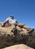
The initial route to 7626' is relatively flat, but after a few minutes, you'll arrive at the base of the boulders that lead to the peak. At this point, [with the many possibilities/route options for reaching 7626'], it turns into a boulder hopping free-for-all. 8) My final approach to the highpoint was from the East, [which I don’t recommend if you have a fear of heights/exposure and/or have never done a Class 4 climb or consider Class 3 to be anything other than 'extremely easy']. Bouldering is my forte, so I had a blast and did not feel out of my comfort zone… however, there were a couple of moments where I found myself strictly adhering to the ‘3 points of contact’ rule… which usually translates to “no f’ing dice!” for the average hiker.

As I neared the summit and suddenly had clear views to the North, thoughts of exploring some of the other 7,000’ peaks/boulder crags went out the window. Despite blue skies overhead, a dark ‘patch’ of virga that was very close was moving in fast from the North; and in the distance, [both to the North and in several other directions], dark clouds loomed.

I signed the registered, took some photos, and admired the views very briefly before getting the hell out of Dodge. Given the weather conditions, the more challenging route I had opted for on the ascent lost it’s appeal, but based on the many signatures in the register, I knew there had to be an easier way down. I noticed a much more beaten in route from the other direction and was on it!

Since enjoying the scenery is usually a top priority, I don’t often kick things into high gear... but with the dark clouds closing in, I hauled pumpkin down! Midway down the bouldering portion, the cloud cover slammed the mountain. Preparing to get drenched and freeze my tail off the rest of the way back, I almost laughed out loud as I got hit with hail instead of rain.

Given that: 7626’ gave me a decent enough pumpkin kicking, I still had more personal biz to attend to, AND the skies did not look like they were clearing up any time soon, I decided to pack it in and head back to the TH. The Granite Mountain area is a beautiful, boulder hopper’s paradise, and I will definitely be back to get 7185’, 7295’, and explore the many other awesome looking peaks/prominent points. No trifecta this time, but I still had a hella good time!
wildflower observationwildflower observationwildflower observationwildflower observationwildflower observation
Wildflowers Observation Light
Sorry, I'm not good with flower names.. see my photoset; I tried to capture one of every color. :)
_____________________
God save the Prom Queen, cuz [reality check!] AEG's King...!
 
Feb 20 2016
avatar

 Photos 188
 Triplogs 163

43 female
 Joined Oct 26 2011
 Tempe, AZ
Granite Mountain Peak 7626Prescott, AZ
Prescott, AZ
Hiking avatar Feb 20 2016
clairebearTriplogs 163
Hiking13.30 Miles 3,117 AEG
Hiking13.30 Miles
3,117 ft AEG
 no routesno photosets
1st trip
I'm glad I had the chance to hike and get this mountain. The lower trails were a breeze and we easily made good time which came to a screeching halt as we entered the higher trails and the summit came into view. Awesome views at the top, but also lots of lady bugs hanging out which is fine, however I was grossed out because I didn't want to crush any of them and at some spots it was difficult. The bushwhacking to the summit was tougher than I anticipated but we still made really good time and were back at the car in the early afternoon. The trails were also fairly empty which was a surprise.
_____________________
 
Feb 20 2016
avatar

 Guides 6
 Routes 183
 Photos 5,612
 Triplogs 1,647

male
 Joined Mar 12 2004
 Scottsdale, AZ
Granite Mountain Peak 7626Prescott, AZ
Prescott, AZ
Hiking avatar Feb 20 2016
John9LTriplogs 1,647
Hiking13.47 Miles 3,190 AEG
Hiking13.47 Miles   6 Hrs   42 Mns   2.40 mph
3,190 ft AEG   1 Hour   5 Mns Break
 
We headed back out to Granite Mountain in Prescott. Kyle and I hiked to the peak a few years ago and decided to return. This time we started with the Little Granite Mountain Loop. We made quick time as we traversed around this side peak. We took a break before we started the hike up the Granite Mountain Trail. We made steady progress as we hiked up the trail. Once up top we opted to head directly for the peak skipping the viewpoint. The going was relatively easy for the first half mile. There were some sporadic cairns that helped but you can’t rely on them and I referred to Route Scout to keep us on track. The climb to the summit went well as we fought our way up. The entire off trail portion of this hike is burned out. I had lots of ash on my hands and clothes.

We topped out and signed the register and took our lunch. The summit is covered in Ladybugs. You had to be careful where you stepped because there were clusters of hundreds of them. After our break we made our return which went really well. We descended from the peak and Lily, Kyle’s dog, did great although I don’t recommend taking dogs to the summit. Once back on trail we flew down and were back to the car around mid-afternoon. It was a nice day in Prescott.
_____________________
  3 archives
Feb 20 2016
avatar

 Routes 67
 Photos 2,708
 Triplogs 755

89 male
 Joined Mar 28 2008
 Phoenix, AZ
Granite Mountain Peak 7626Prescott, AZ
Prescott, AZ
Hiking avatar Feb 20 2016
Tough_BootsTriplogs 755
Hiking13.30 Miles 3,117 AEG
Hiking13.30 Miles
3,117 ft AEG
 no routes
Good hike but the summit was way tougher than I remembered. It could have been the "alternate" route we took up :D We were all pretty ready to be down from there quickly. I couldn't believe the summit was already swarming with ladybugs-- seems early. Lily did really well-- though I wouldn't recommend taking dogs up to the true summit. She loves that kind of climbing but had to find a couple work-arounds on the way down (she never needed to be picked up lowered). Even though she's done more mileage and almost double that aeg in a day-- I would consider this the most challenging hike she's done. It was my first time doing the Little Granite Mtn Loop and that was really enjoyable :D
_____________________
  1 archive
Apr 04 2015
avatar

 Guides 1
 Routes 447
 Photos 4,407
 Triplogs 938

68 male
 Joined Mar 09 2012
 Gilbert, AZ
Granite Mtn 7185 & 7626 via Williamson Valley, AZ 
Granite Mtn 7185 & 7626 via Williamson Valley, AZ
 
Hiking avatar Apr 04 2015
rayhustonTriplogs 938
Hiking20.34 Miles 3,494 AEG
Hiking20.34 Miles   10 Hrs   17 Mns   2.48 mph
3,494 ft AEG   2 Hrs   5 Mns Break15 LBS Pack
 
1st trip
I went soaring with The Eagle along and atop Granite Mountain near Prescott. The trip to the meetup at Happy Valley PNR included a view of a blood moon in the western sky. Thanks for pointing that out, Bruce.

Although this was a single 10 hour hike, you could easily break this down into three separate hikes rated as easy, moderate and somewhat strenuous. The first loop on the route is easy, but not as scenic (suburbs on the east side). The Willow Creek Loop, about nine miles in all, is moderate due to length, mostly flat, and is a gem. It's beautiful all along the route, which includes a side trip to some ruins on the east side and a nice creek (nice flow right now) on the west side. I plan to bring my wife up here first chance I get.

The featured hike today was the Granite Mountain Trail and the Granite Mountain peaks. Most of the elevation gain is along this route. The final ascent is fairly steep along a cairned route. With the exception of the ascent to Peak 7626, the trails are in good shape with nice switchbacks as you ascend the Granite Mountain trail. There are some burn areas along the way, but not too bad. I had a few char marks on my hat and clothes from the final ascent to peak 7626, but I'm not the most graceful hiker. Bruce didn't have a mark on him.

Fabulous 360 degree views from the top. Visibility was as far as the eye can see. It was a wee bit windy on the summit; I nearly lost my hat. Bruce signed the summit log for us. There were no other HAZers noted in the current log.

This was a very enjoyable hike on a gorgeous day. Thanks for the invitation, Bruce. I had a great time!
 Flora
 Flora [ checklist ]
[ checklist ]  Parry's Agave
 Named place
 Named place [ checklist ]
[ checklist ]  Granite Mountain
_____________________
  1 archive
Apr 04 2015
avatar

 Guides 41
 Routes 1,626
 Photos 14,983
 Triplogs 2,760

69 male
 Joined Jan 20 2009
 Far NE Phoenix,
Granite Mtn 7185 & 7626 via Williamson Valley, AZ 
Granite Mtn 7185 & 7626 via Williamson Valley, AZ
 
Hiking avatar Apr 04 2015
The_EagleTriplogs 2,760
Hiking21.56 Miles 3,563 AEG
Hiking21.56 Miles   10 Hrs   16 Mns   2.52 mph
3,563 ft AEG   1 Hour   43 Mns Break15 LBS Pack
 
1st trip
On the way to meet Ray and until the sun began to rise, the Blood Moon was the focal point in the sky. Quite a ghostly red glow.

I did the Granite Mountain Trail and 7626 a few years back with the Turtle, but didn't get to see much through the rain and at times, zero visibility. I wanted to see what I missed the first time, plus add some other trails I'd never been on before.

We started from the Williamson Valley Parkway TH on the Willow Trail #347. The eastern most portion of this trail is just a means to get to the better stuff and allowed us to cruise and warm up from the 36 degree starting temperature. It starts getting a bit roller coastery after you pass the Mint Wash Traill. We took a short side trip to check out the large set of ruins on top of a mound, next to the trail. It had some pretty tall walls in areas. The Willow Trail led us to, Chimbley Water Trail #348 and then to the West Water Trail #351, that took us to the Granite Basin Area. Both of these trail were in great shape and were in tall pines for the most part.

The Granite Mountain Trail #261 follows one of the flowing small creeks that feeds the Granite Basin for 1.5 miles to Blair Pass. The burn from 2 years ago becomes visible just before here. The burn extends to the West, North and East up Granite Mountain.
The climb starts at Blair Pass. We took #261 to it's end and enjoyed the views to the South.

Next it was off trail up to Peak 7626'. We found a cairned route that took us up a little more direct than the last time. It worked out quite well. We passed a group of 4 that were on their way down from 7626. We checked the top for Fliver Disks and the Peak Register. We found one triangulation marker and 2? triangle peak markers, 30' apart. The wind was blowing 40+ mph , so we signed the Register and started down.

The Mint Wash Trail #345 was another pleasant surprise. This trail starts right behind the Granite Basin Dam and follows a pretty little flowing creek until you meet back up with the Willow Trail intersection. It then climbs out of the creek area and gives you some great views of the riparian area below.

A fun day with some perfect weather (after it warmed up).

Thanks for joining me and driving Ray!

Granite Mountain Views :next: https://youtube.com ... A7Ng
 Fauna
 Fauna [ checklist ]
[ checklist ]  Gopher Snake
wildflower observationwildflower observationwildflower observationwildflower observationwildflower observation
Wildflowers Observation Isolated

water 1 out of 5water less than maxwater less than maxwater less than max Alkali Spring Dripping Dripping
Water in the area, but no spring in the Topo location.

water 1 out of 5water 2 out of 5water 3 out of 5water 4 out of 5 Granite Basin Lake 76-100% full 76-100% full
Lots-o-water. But there's faucets available to fill from

water 1 out of 5water 2 out of 5water 3 out of 5water less than max Mint Spring Gallon per minute Gallon per minute
Nothing at the spring location, but Mint Creek flowing all the way.

water 1 out of 5water 2 out of 5water 3 out of 5water less than max Mint Wash Waters Gallon per minute Gallon per minute
Flowing
_____________________
There is a very fine line between "hobby" and "mental illness."
Dave Barry 🦅
  3 archives
Jan 05 2015
avatar

 Routes 297
 Photos 6,928
 Triplogs 552

49 male
 Joined Dec 30 2007
 Avondale,Az
Granite Peaks-Snow hike, AZ 
Granite Peaks-Snow hike, AZ
 
Hiking avatar Jan 05 2015
StoicTriplogs 552
Hiking14.40 Miles 3,893 AEG
Hiking14.40 Miles   9 Hrs   37 Mns   1.62 mph
3,893 ft AEG      45 Mns Break15 LBS Pack
 
1st trip
I started my hike around 6:25am. The gates didn't open to the trailhead until 7am, so I had to start further back. This added 1.5miles to the hike. The hike started out great. The weather wasnt to bad and the trail was easy to follow. By 7:30am, I had already taken off my jacket. 4 miles into the hike, I went off trail to bag 7295. From this point I didnt see any footprints. The first half mile went smooth. The last 1/4 mile was rough. Bushwhacking and climbing boulders in the snow. I stayed a couple minutes then went on my way. I went down a different way to try to cut out some of the bushwhacking. This worked out well. There where more boulders and less bushes. I headed back to trail #261. I then took trail 261 to the end. I climbed up some boulders as far as I felt comfortable. I was about 10 feet from the highest point. I then backtracked 261 about 1/2 mile. Here I started for Granite Peak 7626. There where no trails past trail 261. Some occasional cairns, but no distinctive trail. 1/4 mile later, I ran out of footprints to follow. I was on my own. It took me 90 minutes to go the next 1.1 miles. I didnt stay up here to long, maybe 10 minutes.
Overall a great hike, with perfect weather. Im guessing mid-high 40s at the top, with a cool breeze. It was a full body workout. My upper body from all the climbing and my lower legs from all walking in snow. I am feeling it today (2 days later)
 Culture
 Culture [ checklist ]
[ checklist ]  Summit Register Log
_____________________
  1 archive
May 28 2012
avatar

 Guides 10
 Routes 673
 Photos 7,281
 Triplogs 4,660

67 female
 Joined Nov 17 2008
 phoenix, az
Granite Mountain Peak 7626Prescott, AZ
Prescott, AZ
Hiking avatar May 28 2012
trekkin_geckoTriplogs 4,660
Hiking10.55 Miles 2,700 AEG
Hiking10.55 Miles   5 Hrs   23 Mns   2.31 mph
2,700 ft AEG      49 Mns Break
 no routes
1st trip
Linked   linked  
Partners partners
johnlp
john and i have been trying to find a day to get up to prescott
we both wanted to hike granite mountain trail, which i've done before, but also get peak 7626
left the valley early this morning and were on the trail before 7:00
granite mountain trail is very nice, with good footing, great scenery, and the smell of pine needles on a cool morning
easy uphill to the intersection with little granite mountain trail, then a more moderate climb
reached the point where the summit trail splits off from the viewpoint trail and then the fun started
the first part of this is easy enough and well marked
the scramble is fun, but it's easy to get off route even with a gps track and cairns
gps joe's track didn't always match the cairned route, but we were always able to reconcile the two
had to tip-toe through quite a few blooming manzanita patches, buzzing with bees
lots of bees
the summit was cool, with great views, a benchmark and a register
bugs weren't bad, although some recent triplogs mentioned that they were quite annoying
headed down, following both the track and cairns, then four mistakes happened - all mine
1. got slightly off trail, and i wasn't paying attention, so that became way off trail
2. didn't immediately return to the last known spot, thinking we could pick our way back to the trail
3. i don't have my breadcrumb tracking activated on my gps, so i couldn't even backtrack correctly
4. in stepping over a flock of agave, my foot slipped, resulting in a stab wound into the muscle on the inside of my left knee :o
that hurt, still does, and i can now barely bend my knee or put weight on my left leg
guess i will ride my bike tomorrow
bushwhacked our way back to trail 261 and went up to the viewpoint
easy trip back down, actually hiking on a trail
i love this hike, especially the pine trees and all the boulders
i liked the climb to the summit - enjoy scrambling
thanks john, for tackling this one with me, and sorry about that bushwhack :? : rambo :
cost us a good 30 minutes or so
also made us change our plans for our second hike
 Culture
 Culture [ checklist ]
[ checklist ]  Benchmark
_____________________
hazhole
 
May 28 2012
avatar

 Guides 1
 Routes 14
 Photos 7,202
 Triplogs 5,208

68 male
 Joined Mar 16 2008
 chandler,az
Granite Mountain Peak 7626Prescott, AZ
Prescott, AZ
Hiking avatar May 28 2012
johnlpTriplogs 5,208
Hiking10.55 Miles 2,700 AEG
Hiking10.55 Miles   5 Hrs   23 Mns   2.31 mph
2,700 ft AEG      49 Mns Break
 no routes
1st trip
Linked   linked  
Partners partners
trekkin_gecko
Fun hike with trekkin gecko. Got a little off the route on the way down from the peak to the trail, but eventually ran across the trail. Went to the viewpoint then back down to the trailhead. Nice trail.
wildflower observationwildflower observationwildflower observationwildflower observationwildflower observation
Wildflowers Observation Light
_____________________
“Good people drink good beer.” Hunter S Thompson
  1 archive
May 13 2012
avatar

 Guides 6
 Routes 183
 Photos 5,612
 Triplogs 1,647

male
 Joined Mar 12 2004
 Scottsdale, AZ
Granite Mountain Peak 7626Prescott, AZ
Prescott, AZ
Hiking avatar May 13 2012
John9LTriplogs 1,647
Hiking10.60 Miles 2,800 AEG
Hiking10.60 Miles
2,800 ft AEG
 
Linked   linked  
Partners partners
Tough_Boots
It was another great day out on the trails! Originally Kyle and I were planning on hiking in the eastern Supes but the temps were a little on the warm side. I wanted to find a hike that had some elevation hoping it would be a little cooler. After seeing Juan Jaime's pics from Granite Peak last week, this looked like the perfect hike.

We started our hike around 9am and made quick time heading up the trail and up the switchbacks. We took a short walk over to the main viewpoint and enjoyed the views and a quick snack. From there we headed back and picked up the spur trail that leads to Granite Peak. The first half mile is very easy going. There were plenty of cairns to follow and we both had GPS with a track preloaded from one of our fellow HAZ members. This helped tremendously.

The "trail" then starts climbing and this is where things get interesting. You have to scramble up a draw and we were constantly looking for the next cairn. It really helped having both of us route finding because it was easy to wander off the path. The second person could scan for the next marker. This kept us on track. We went back and forth as the leader. The scramble is definitely a challenge and was a lot of fun! After considerable effort we reached the summit. We had a look around and found the trail register. The gnats were extremely annoying so we quickly signed the register and dropped down a little bit to have lunch in some shade.

After lunch we started our descent. It was much easier going down. We retraced our steps and were back on level ground in no time. The rest of the return flew by and we were back at the car in no time. This was an excellent hike that I would definitely do again someday.

On the ride home, we had a good look at the Gladiator Fire burning near Crown King. It looked really bad and is an ominous sign for the start of the fire season.
 Culture
 Culture [ checklist ]
[ checklist ]  Summit Register Log
_____________________
 
average hiking speed 2.13 mph
1, 2  Next

WARNING! Hiking and outdoor related sports can be dangerous. Be responsible and prepare for the trip. Study the area you are entering and plan accordingly. Dress for the current and unexpected weather changes. Take plenty of water. Never go alone. Make an itinerary with your plan(s), route(s), destination(s) and expected return time. Give your itinerary to trusted family and/or friends.

helpcommentissue

end of page marker