|
| | | |
| |
|
| Canyoneering | 3.00 Miles |
1,000 AEG |
| | Canyoneering | 3.00 Miles | | | |
| 1,000 ft AEG | | | | |
|
|
| | |
| Linked |
|
none
[ show ]
| no linked trail guides |
| Partners |
|
none
[ show ]
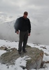
| no partners | | | Found this hike on HAZ , thanks are due to previous trip-log contributors. Not too far out of town, secluded location and great views. Lots of animal sign but only seen one whitetail deer on top. Too fast for a picture. The hike up to the saddle is loose and steep in places but not really bad and does keep the hike restricted to those that don't mind a little sweat. Once on top it's a walk in a park. Of course we were not there to attempt the technical part of this hike, it was only an out and back to the drop off. |
| _____________________
| | |
|
|
|
 Route Editor