|
| | | |
| |
|
| Hiking | 17.40 Miles |
4,609 AEG |
| | Hiking | 17.40 Miles | 8 Hrs 50 Mns | | 1.97 mph |
| 4,609 ft AEG | | | | |
|
|
| |
| Linked |
|
none
[ show ]
| no linked trail guides |
| Partners |
|
none
[ show ]
| no partners | | Wow! .... Did I forget to say ...Wow!! What a beautiful day for a hike. I got a bit of a late start, 7:50, I was shootin' for 7:00, but oh well. This trail has a very gradual incline, often seeing the switchback a stones throw below, 100 yards from the turn, but steadily climbing the whole time. Big pines at the start, giving way to a mix with aspen and grasses, lupine, various other flowers and ground cover. A great start for a long hike.
About a mile up the trail you come to a fork, the Weatherford angles left, Three hikers behind me went right, I met them on the trail about a mile and a half later. I highly recommend this cut-off trail, I took it on the way back. This trail goes through the Aspen Spring meadow area, a beautiful aspen filled valley, well worth the short-cut.
I found my way to Doyle Saddle after about 2 hours 10 minutes, from there you can see Humphreys, Agassiz and the trail cutting across the snow pack. Black dots, hikers were visible crossing the snow a few miles ahead, time to get movin'. A mile or so later the trail turns up through a tree lined area with at least 7 or 8 downed trees, which require you to step or climb over them, some still in the snow. This area would be challenging for short legged hikers.
You soon pass Freemont Saddle, the 11,000 foot mark and work your way above tree line and the around the back of Agassiz. From here you can see most of Flagstaff below, a snow pack ahead and Humphreys still in the distance. Crossing the snow was fun, but a slip and fall would land you far below, with good speed, right on the rocks, so watch your step.
Agassiz Saddle was next and the first view down the Snow Bowl side to the parking lot and Humphreys TH, which I found was quite crowded as I headed down to the Humphreys Saddle, oh my .... look at all those people. It was a bit like Piestewa Peak, well, down to the saddle and up to the peak with all the people. I found this part a bit more taxing on the body then last years hike, I think it was having almost 8 miles on the legs and 12,000 feet might have something to do with it 
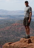
At the summit! After 4 hours 40 mins, it's time to sit ..Woo Whoo! It was easy to find one of the 20 -30 people to take a picture by the summit sign. Oh yea, talk about bugs... there were swarms of bugs all over the top, I guess with minimal wind, about 70 degrees and lots of sunshine, their has to be a down side.
The view was spectacular, I ate lunch drank water and rested for about 20 minutes, then I thought to my self .... as I looked across the Inner Basin ....... Wow! .... now I have to go back
Yea .... I'd do it again |
| _____________________
| | |
|
|
|
 Route Editor


 After a discussion & giving my info, I got a pass

