|
| | | |
| |
|
| Hiking | 8.50 Miles |
1,273 AEG |
| | Hiking | 8.50 Miles | 2 Hrs 57 Mns | | 2.88 mph |
| 1,273 ft AEG | | | | |
|
|
| |
| Linked |
|
none
[ show ]
| no linked trail guides |
| Partners |
|
none
[ show ]
| no partners | | Warmed up quick! Solitude type of hike, almost got lost a handful of times.
First time on this trail (hike/jog)...yes I took the right trail this time! Started at the Huckaby Trailhead (I believe) which is the trail head for Mund's Wagon Trail, Marg's Draw and Huckaby.
Went in a clockwise from Mund's Wagon to Hangover Trail to Cow Pies back to Mund's Wagon.
The trail was well marked but it does require crossing the road then hopping back on to the trail, which is confusing for me (got lost on the way back).
Munds Wagon trail is an easy stroll to the trail marker for Hangover. Nice cool weather early in the day, streams were flowing (not yet dry). After going up short switchbacks at Hangover I think I may have gotten lost because it was a steepish scramble up. I followed the white paint markings, there was one mountainbiker going down the same path so I thought I was going the right way. Once I finished scrambling up, I turn to a corner where I saw those white pain markings again, which may be the correct path (i am not describing this well lol).
After that section the trail was easy to follow again. Narrow, well groomed path. I would suggest to be on high alert because at any time there could be a mountain biker racing the opposite direction and once slip could send you rolling downhill.
I was the loner hiker from Mund's Wagon-Hangover intersection until I got to highest point of Hangover. There were 3 groups of hikers at the top, I am guessing they took Schnebly Hill to Cow Pies. I had to ask someone where the trail was going to down to make a loop (i.e. how to get to Cow Pies). He pointed me in one direction and I had to go back up to the mesa and just follow the white paint marks going down. Found Cow Pies and stayed on Mund's Wagon but must have taken a wrong turn (this is what happens when I run downhill) and ended up at Schnebly Hill road at a point where it says there is an equestrian bypass. had to ask a mountain biker for directions, when I started running back up the hill he hollered and said i should be going down the canyon.  So I then took the 'equestrian bypass' and ended up running along side Pink Jeeps on Schnebly Hill. I saw a trail runner (looked like the owner of the local running store, he had been going up Hangover while I was starting back down) who directed me back to Mund's Wagon and I was able to make my way back to the trailhead at that point. So I then took the 'equestrian bypass' and ended up running along side Pink Jeeps on Schnebly Hill. I saw a trail runner (looked like the owner of the local running store, he had been going up Hangover while I was starting back down) who directed me back to Mund's Wagon and I was able to make my way back to the trailhead at that point.
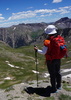
Views were absolutely gorgeous! If you are looking for a less busy hike I would highly recommend Hangover. (just be on the lookout for bikers  ). ). |
| _____________________
| | |
|
|
|
 Route Editor


 Took the 2nd to the last parking spot when i go to the trail head.


 There was certainly no water in the 'tank', it also looked like the area was burned at some point..the tree was burnt and split in half.

