|
| | | |
| |
|
| Hiking | 4.50 Miles |
1,350 AEG |
| | Hiking | 4.50 Miles | 2 Hrs 10 Mns | | 2.08 mph |
| 1,350 ft AEG | | | | |
|
|
| |
| Linked |
|
none
[ show ]
| no linked trail guides |
| Partners |
|
none
[ show ]
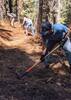
| no partners | | Wanted to check out the Wet Canyon re-route being completed by the Fort Grant Prison Crew that has been in progress on and off since Sept 2021. The re-route seems to be about 80% complete. For the first time since before the 2017 Frye Fire; one can reasonably hike down to the creek and back up to the other side in their attempt climb or descend Arcadia NRT! Photos in my photo set. Amazing work done by the Fort Grant Prison Crew.
Beyond Wet Canyon volunteer and prison crew maintenance was performed between Nov 2020 and Sept 2021. Work consisted of clearing overgrown brush and removal of downed trees blocking the trail corridor. The very wet monsoon of 2021 and the winter season have brought back some overgrowth and per the usual post winter scenario more down trees.
The lower 2.5 miles of trail is in reasonable shape except for some thorny locust bushes starting about 1 mile in. The locust tends to be in exposed areas vs. the piney areas. After the intersection with the remnants of the Noon Creek Ridge Trail, which is also near the 2.5 mile mark the trail, piney debris and down trees start to become more frequent. I did not make it beyond this point.
In general, between the Noon Creek Ridge and the Heliograph trail intersections, on Arcadia, you will encounter dead fall, debris and locust in the burn scar. Based on work done in September 2021 the trail should be passable all the way up to Shannon once the snow melts out fully. Though, I would caution that it could be very slow going depending on down trees, navigating thorny bushes and baby aspen growing into the tread as you get above 8000ft.
The plan for fall 2022 is to get this trail fully clear and open for multi-use However, starting April 1st power tools cannot be used until Sept 1st due to Mexican Spotted Owl nesting season. Power tools for all intents and purposes are required for any level of reasonable productivity in clearing downed trees. Some of these trees are over 3ft in diameter.
SDMB, a multi-use trails advocacy organization, based in in Tucson, has a volunteer agreement, in place with the USFS for maintenance on Arcadia Trail and others: Ladybug, RTM, Noon Creek, Shake Trails. There are plans to have volunteer work days on Arcadia scheduled for this summer with camping at Arcadia and Shannon Campgrounds.
Want to get involved with trail work?
↓ See my signature below ↓ |
| _____________________
Sonoran Desert Mountain Bicyclists
Mt Graham Volunteer Trail Work Coordinator
Want to volunteer? Email: communications@sdmb.org
Instagram @sdmb_mtb |
| | |
|
|
|
 Route Editor