 Route Editor

| Guide | ♦ | 35 Triplogs | 0 Topics |
details | drive | permit | forecast | 🔥 route |
stats |
photos | triplogs | topics | location |
| 246 | 35 | 0 |
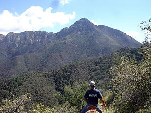
Sweet Alternative by fricknaley   This is a very nice loop hike in the Santa Ritas - a favorite range of mine. A short drive south of Tucson, and you're in pine forests. The trail is a great loop, with a very tough beginning, just excellent scenery the rest of the way. When you start, you may think that this will be too much, but after about two miles, it becomes pretty easy, and the rest of the way is just about incredible southern Arizona mountain scenery. The whole trail is well signed, well maintained, and very easy to follow. This is a very nice loop hike in the Santa Ritas - a favorite range of mine. A short drive south of Tucson, and you're in pine forests. The trail is a great loop, with a very tough beginning, just excellent scenery the rest of the way. When you start, you may think that this will be too much, but after about two miles, it becomes pretty easy, and the rest of the way is just about incredible southern Arizona mountain scenery. The whole trail is well signed, well maintained, and very easy to follow.Start on Old Baldy Trail #372 out of the parking lot and very quickly come to the official signed break-off point for the old baldy trail (to your left). Continue on the signed Vault Mine Trail #77 and immediately start climbing. Climb along the canyon floor and creek for a while, then the trail gradually breaks off left and starts climbing through low forest. Shortly you come to another signed intersection about 0.8 miles in or so. The new Carrie Nation Trail #78 goes ahead, and the Vault mine trail breaks off slightly to your right. Just follow the signs to vault mine. Now comes the challenging part of this hike. The next mile or so is pretty darn steep but persevere, take breaks and enjoy the ever-improving scenery, and before too long, you come to another intersection, where the vault mine intersects/dead-ends into the Agua Caliente Trail #140.
After about 2.2 miles or so, you come upon the signed Josephine Saddle - a major intersection in this area. Your choices back include Old Baldy at about 2-2.5 miles or the Super Trail #134 at about 4. I took the Super Trail for the easy trip back down. There are great views of Mt. Hopkins on the way down with its telescope occasionally visible. Shortly enough, you are back in the parking lot where you started. Coronado FS Details Agua Caliente Trail #140 and Very Steep/Vault Mine Trail #77 These two trails provide access to the upper slopes of Mt. Hopkins, the second most prominent peak in the Santa Ritas. The Agua Caliente Trail winds along Hopkins' north slopes through a cool forest of conifers, oaks, and aspens, providing good views of the Multiple Mirror Telescope on the mountain's summit as well as the upper reaches of Madera Canyon and Mt. Wrightson's rocky prominence across the canyon. Off in the distance, the Santa Cruz Valley and the Santa Catalina and Rincon Mountains stretch toward the horizon. There are three main ways to approach this scenic area, the most direct and most demanding of which is via the Very Steep/Vault Mine Trail out of Roundup Picnic Area at the end of Madera Canyon Road. This trail earned its descriptive name from the fact that it climbs 1,400 feet in a distance of a little over one-half mile. This heart-thumping climb leads from upper Madera Canyon to the vicinity of Agua Caliente Saddle, where that trail branches off toward Josephine Saddle and a number of other trails that crisscross the upper slopes of the Santa Ritas. Agua Caliente's trailhead is located in a canyon of the same name on Mt. Hopkins' western flank. From that point, accessible via Mt. Hopkins Road, the trail proceeds up a remote desert canyon toward the mountain's forested upper slopes. If you arrange a shuttle in advance, a trip that stretches between this trailhead and the VS/VM trailhead in Madera Canyon makes a good long day. A loop that doesn't require a shuttle takes you up the VS/VM trail to Agua Caliente Saddle, then northeast to Josephine Saddle, and back to the Roundup parking area via the lower end of either Old Baldy or Super Trail. Attractions: Access to Mt. Hopkins, Great views, streamside to desert diversity & Physically challenging Access: Very Steep/Vault Mine: Leave Interstate 19 at the Continental Exit/Madera Canyon Road. Turn east and follow the Madera Canyon road (FR 62) about 13.5 miles to the Roundup Picnic Area entrance then turn left into the trailhead parking lot. Agua Caliente: Leave Interstate 19 at the Canoa Road Exit. Take the east frontage road 3 miles south to Elephant Head Road and turn east 1.6 miles to Mt. Hopkins Road. Drive 4.5 miles to FR 183. Turn north on this dirt road about 2.4 miles to the trailhead at the canyon. Notes:1.5 miles of the Very Steep/Vault Mine Trail and 4.7 miles of the Agua Caliente Trail are within the Mt. Wrightson Wilderness. Motorized and mechanized vehicles and equipment, including mountain bikes, are not permitted in Wilderness. Check out the Official Route and Triplogs. Leave No Trace and +Add a Triplog after your hike to support this local community. | ||||||||||||||||||||||||||||||||||||||||||||||||||||||||||||||||||||||||||||||||||||||||||||||||||||||||||||||||||||||||||||||||||||||||||||||||||||||||||||||||||||||||||||||||||||||||||||||||||||||||


