| |
| West Fork Pinto Creek - Cuff Button Loop, AZ | | -
| 1 label | 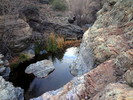 |
|
|
-
| 1 label | 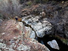 |
|
1 |
-
| |  |
|
2 |
-
| 1 label | 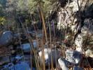 |
|
|
-
| 1 label | 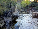 |
|
1 |
-
-
| |  |
|
1 |
-
-
-
-
| |  |
|
2 |
-
-
| 1 label | 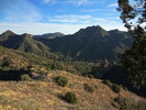 |
|
2 |
-
-
| 1 label |  |
|
|
|
| | West Fork Pinto Creek - Cuff Button Loop, AZ | | | |
|
|
West Fork Pinto Creek - Cuff Button Loop, AZ
| | |
|
| Hiking | 17.80 Miles |
2,549 AEG |
| | Hiking | 17.80 Miles | 10 Hrs 10 Mns | | 1.89 mph |
| 2,549 ft AEG | 45 Mns Break | 12 LBS Pack | | |
|
|
| |
| Partners |
|
[ show ]
| partners | | Bruce's Nonesuch Rocks - Pinto Creek Loop back in April was such a gem I had been itching to get back into the mighty scenic Pinto. A while back I threw this loop together "my style" in a couple minutes. Finally managing to push it through after countless vetoes. The shocking part was slipping it past his audit stage. Bruce's hallmark of superior planning really helps keep me sane managing HAZ operations. Yet it was kind of cool to have that clueless feeling today tackling today's loop.
What is Cuff Button? It's a horrible trail. The triplogs do not lie. Yet I still wanted to get out and experience the horror myself.
How bad was it? Pretty bad in spots. If not for a Hikebot route pieced together from Stiller / r4gl7q / Kanode ( each of which has excellent triplogs I might add ) this would be one ridiculous time consuming route finding adventure. Bruce's arms looked a bit bloodied by the end. I fared better under the "push the runt in front" tactic.
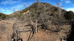
Would I do it again? Probably. It comes down to nice weather, nice views and I enjoy the area as a whole. Going through one thirty foot impossible-to-find without-gps section got my attention. Old and older cuts where fellow hikers have laboured to keep this trail alive displays the adventure we share. Perhaps hate it enough to swear it off. Okay, whatever. IMO this trail is a mini-trophy few acquire in the mighty overrun wilderness. This isn't Twin Peaks or Mound via Campaign bad, it just requires some patience. I will say the camping options on #276 proper looked bleak but there are a few "in a pinch" options.
The unexpected show!
It had been awhile since I threw this together. We didn't even know the name of the creek we followed heading towards Horrell @ 7:30am. One thing for sure, it was special. The sycamore shrine was narrow in spots requiring high exits. A running creek likely due to the recent rains. Rock formations, spires and Mazzie undertones. While we bitched and got concerned on the slow travel it was best not to rush West Fork Pinto Creek. |
|
Autumn Foliage Observation Light
Pretty much in the toast phase, I'd guess a good 10 days after prime. Note: this year ran a few days early statewide for future reference. |
|
  |
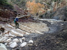
Horrell Creek |
Light flow |
Light flow |
| | | A light flow pretty throughout. Note: now a week after a 3 inch rainfall |
|
West Fork Pinto Creek |
Light flow |
Light flow |
| | | Light flow near Miles. Dry near Horrell. I joked with Bruce about filtering this with a bandana cowboy style. In all honesty I wouldn't drink this water filtered through my ceramic pump unless in a pinch. The area is overrun by cows. | | _____________________
| | |
|
|
|
|
|
| |
 Route Editor


