| | -
-
-
| 3 labels | 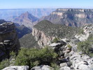 |
|
|
-
-
| 1 label | 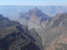 |
|
|
-
-
| 1 label | 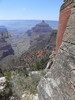 |
|
|
-
-
-
-
| |  |
|
2 |
-
| 2 labels | 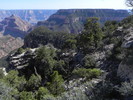 |
|
|
-
-
|
| | |
|
| Hiking | 18.75 Miles |
3,999 AEG |
| | Hiking | 18.75 Miles | 11 Hrs 15 Mns | | 1.67 mph |
| 3,999 ft AEG | | | | |
|
|
| |
| Linked |
|
none
[ show ]
| no linked trail guides |
| Partners |
|
[ show ]
| partners | | We were looking for a higher, cooler adventure this weekend. This seemed to be the ticket, but we hit this on a hot day. That seems to be a recent theme in Shiva's summit log.
The walk through the North Rim forest is long, but easy. Navigation with a GPS is quite helpful from the Tiyo Point road junction to Shiva Point. From there, the route down to Shiva Saddle is relatively straight-forward, as there are bits of trails and routes here and there. We stayed on or near the main ridgeline from the point down to the saddle, for the most part. The lower part through the Coconino is steeper, looser, and less shaded, but is over quickly.
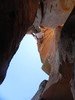
After crossing Shiva Saddle, staying on the ridgeline towards Shiva was the ticket to the base of the Coconino. A very Isis-esque Hermit Shale gully traverse appears, and the climbing starts after that. It was pretty straight-forward and fun scrambling. After topping out in the Coconino, we made our way to the final Kaibab barrier. An annoying, exhausting sidehill came next, but at least we were in the shade under cool pines! Steep, loose final climb to the top brought us to the famous jugs! A stroll (and a brew) on the south edge was the reward.
Hot day - even up this high. Highs were well into the 90s down at Shiva Saddle. Went through over 5L of fluids and would have drank more if it were available. Back on the rim by mid afternoon and enjoyed the pines and aspens on the relaxing walk out. |
| _____________________
| | |
|
|
|
|
|
| |
 Route Editor


