| | -
-
-
-
-
-
-
-
| 2 labels | 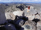 |
|
1 |
-
-
| 2 labels | 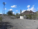 |
|
|
-
-
|
| | |
|
| Hiking | 6.50 Miles |
1,700 AEG |
| | Hiking | 6.50 Miles | | | |
| 1,700 ft AEG | | | | |
|
|
| |
| Linked |
|
none
[ show ]
| no linked trail guides |
| Partners |
|
none
[ show ]
| no partners | | Turned out to be a great day, despite the foreboding forecast. Eric and I parked a couple miles north of Belmont, made our way across the desert, and spied a ridge leading from the desert floor on the north side straight to the summit. It was most certainly steep, but not as bad as it looked from afar. Route-finding was easy, but involved some cliff-dodging (and, occasionally, climbing  ) Atop the Belmonts, we signed in and enjoyed the view, wanting to extend the day. ) Atop the Belmonts, we signed in and enjoyed the view, wanting to extend the day.
We descended via the airy and rugged northwest ridge, which took much longer to descend than our route took to climb, and this deposited us near Beer Bottle Well (great name!) just off the main dirt road. We could have just walked the road back to the CR-V, or....We looked at the time and saw we still had plenty, and went after Peak 2340. She turned out to be a surprise - who knew such a small mountain could pack such a wallop? Jalapeno, at least, on the spice scale. As one of the two people to have signed the summit register said (last signed in 2004), "It was a sporty climb!" Indeed. Recommended if you're in the area!
We dropped off the northeast side of Peak 2340 as a thunderstorm made its way across the valley to the north, but never threatened us. |
| _____________________
| | |
|
|
|
|
|
| |
 Route Editor


