| | -
-
-
-
-
| |  |
|
2 |
-
-
-
-
-
-
| |  |
|
1 |
-
-
|
| | |
|
| Hiking | 4.26 Miles |
1,509 AEG |
| | Hiking | 4.26 Miles | 3 Hrs 28 Mns | | 1.36 mph |
| 1,509 ft AEG | 20 Mns Break | 28 LBS Pack | | |
|
|
| |
| Linked |
|
none
[ show ]
| no linked trail guides |
| Partners |
|
none
[ show ]
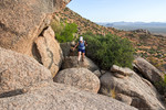
| no partners | | Heather and Dave joined me for a hike of the Hog Heaven Loop in the McDowell Mountains.
We hiked Tom's Thumb to the Mesquite Canyon Trail and then turned left on Feldspar for a short ways. We took the climber's access trail past the Girlie Man Wall, then past at least one of the Sven Towers on our way up to the pass at the top of Mesquite Canyon. From there, we proceeded on to Hog Heaven. When I had last done this route in April, I got slightly lost in the tall grass. That wasn't a problem on this hike. There was a clear trail through the now much shorter grass. You do still have to look for single stone cairns in the rocky sections, however.
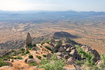
Anyway, we continued up to Hog Heaven and then past it to the Thumbnail Pinnacle. Dave and Heather rested in the shade of the pinnacle as I took a few photos. It was a warm day, so I took fewer than normal.
We continued up past the Thumbnail Pinnacle to the ridge that leads to Hog Heaven. I know of two good ways to do this ridge. The first, which I don't like as well starts on the left (SSW) side of the ridge and then goes up to the NNE side of the ridge. The other way to start the ridge is to stay on the NNE side of the ridge. Although the trail is not obvious - since it goes over a number of granite boulders - it feels easier and more straightforward to me. There is less loose gravel and fewer bushes to push past. However, on my visit in February, I noticed a lot of bees on the NNE side of the ridge, so opted for the route with fewer bees. On this particular hike, I didn't see any bees at all.
Regardless of which way you start, the route goes WNW along the NNE side of the ridge and then crosses over to a 20 foot (or so) loose and steep descent on the SSW side of the ridge. From there it traverses somewhat below the top of the ridge, eventually coming to the fenced in radio repeater just below the East End Summit.
We summitted and then headed down to Tom's Thumb Trail. The day was warm enough that we chose not to do either of the other two (more fun) options for getting back to the trailhead.
As we neared the trailhead, we met a fellow who was testing a prototype of a personal mister system. It seemed quite effective as I felt a bit of the evaporating mist from his gizmo has he passed me. Very cool! - Literally! |
| _____________________
| | |
|
|
|
|
|
| |
 Route Editor


