| | -
-
-
| 1 label |  |
|
1 |
-
| 1 label | 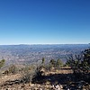 |
|
2 |
-
-
|
| | |
| |
| |
| Partners |
|
[ show ]
| partners | | My previous attempt at this summit was plagued by probable fever in February of 2019. During that attempt I reached the first ridgeline and quit at the unique geographic formation that includes flat rocks which at the time were pleasant to rest on.
Today there was no stopping @LindaAnn and I making it to the 7,449' summit.
The trail and off-trail tracks here are both steep once the trail leaves Mineral Creek. The on-trail portion is characterized by steep, slippery gravel. The off-trail portion is steep with slippery shale from trail #24 to the higher portions on the shoulder of North Peak. Approximately 600 vertical feet from the summit the off-trail turns into more of a scramble which was a lot of fun and a highlight of the day.
The summit was perfect. The skies were clear and the weather was perfect. The views to the rim, Lake Roosevelt, San Francisco Peaks and points beyond were incredible. I haven't ever seen such visibility looking out from the Mazzies.
Getting to the trailhead was smooth sailing. The steepness of the trail was a lot more fun than last time. Great company, perfect weather and we didn't see anyone all day. |
| _____________________
Wildflower seed in the sand and wind
May the four winds blow you home again |
| | |
|
|
|
|
|
| |
 Route Editor


