| | -
-
-
-
-
-
-
-
-
| |  |
|
1 |
-
-
-
-
|
| | |
|
| Hiking | 9.44 Miles |
738 AEG |
| | Hiking | 9.44 Miles | 4 Hrs 21 Mns | | 2.21 mph |
| 738 ft AEG | 5 Mns Break | | | |
|
|
| |
| Linked |
|
none
[ show ]
| no linked trail guides |
| Partners |
|
none
[ show ]
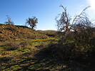
| no partners | | I didn't do the loop, just the first part of it to the ovens. Then I took the unmarked horse trails to the north. I saw these trails on the satellite photos and had a loop mapped out going to the east. But when I got to the end of what I mapped, there was still a trail to follow. I followed it until it faded away, then wandered that area and found another one, plus several other junctions for spur trails. I was at 4 to 5 miles when I ran out of trails, so I just ended up hiking back, getting in close to 10 miles for the day, good enough.
At the north end, several horses were seen in the distance on the hills. I wasn't very far from the Bush and Beeline Highways at my turnaround spot, but I couldn't see either of them due to the terrain. Had a very remote look to it.
Didn't see any other hikers until I got all the way back to the trail by the river, then it was pretty busy. Very chilly to start in the morning before the sun came up. Still stayed cool enough to be comfortable and not need much water. There are more horse trails to explore here, but the part of the trail by the river that goes under the eroding cliff with the boulders in the dirt gives me the heebee-geebees. |
| _____________________
| | |
|
|
|
|
|
| |
 Route Editor


