| | -
-
-
-
-
-
-
-
| |  |
|
3 |
-
-
-
-
| |  |
|
1 |
-
-
|
| | |
|
| Hiking | 10.85 Miles |
2,509 AEG |
| | Hiking | 10.85 Miles | 5 Hrs 28 Mns | | 2.00 mph |
| 2,509 ft AEG | 3 Mns Break | | | |
|
|
| |
| Partners |
|
none
[ show ]
| no partners | | I haven't done the Prospector Loop, Lost Ranch or Gila Trails in 14 years (back when one was called Bees Knees). once I found the new trailhead, I started on the Bursera to the Gila, then up Lost Ranch, down the west trail of the Prospector Loop, then immediately back up the east trail of the Prospector Loop, then west on the National Trail and took the Gila Trail back to the trailhead.
The two ascents early on made for a nice workout. On the way up Lost Ranch it was starting to feel hot already, but then up on the National the breezes cooled me off very quickly. Taking the east part of the Prospector loop gave me a little more shade with the sun still kind of low. By the time I was done, it was getting a little warm.
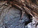
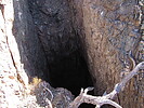
Lots of prospects and abandoned mine shafts along the way. I discovered a new one that looks pretty dangerous. It's still cool to see these, but I'm always surprised there aren't more injuries from curious hikers.
Only saw a few people on those steep trail, most were on the National or Gila. the last mile before the trailhead had the most foot traffic. This one took a little longer with the elevation gain, but made for a nice workout hike. |
| _____________________
| | |
|
|
|
|
|
| |
 Route Editor


