|
| | | |
| |
|
| Backpack | 32.82 Miles |
7,645 AEG |
| | Backpack | 32.82 Miles | 2 Days 21 Hrs 15 Mns | | |
| 7,645 ft AEG | | | | |
|
|
| |
| Linked |
|
none
[ show ]
| no linked trail guides |
| Partners |
|
none
[ show ]
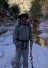
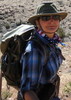
| no partners | | Was originally going to do this Memorial Day weekend, but had to reschedule due to Covid closures. Probably a good thing; October is prime time for North Bass. The plan was to hike down to Shinumo Creek via the lower White Canyon detour, camp there two nights, and hike around Shinumo Creek in the interim, before hiking up to Mauv Saddle for a 3rd night and short hike back to the car.
Friday
Things got to a rocky start when I (probably) strained a muscle in my lower back positioning my pack in my Jeep. Then we wasted about 20 minutes trusting google for directions to the TH; when I realized it was wrong, there was no coverage, so I had to rely on faint years-old recollections to finish the job. But we got there.
Made pretty good time down to the bottom of the Redwall, then the nightmarish vegetation in the middle White Creek narrows slowed progress considerably. We took a break at the little slickrock section before the trail temporarily exits. After the bypass, we were back in the wash, and this was officially further I had ever been down this trail (made it through the narrows on a day hike 3 years ago).
I was getting slightly worried about daylight; it was 4pm or so when we got to the location where the trail exits White Creek for good, and while the narrows section would be a much shorter distance, I wasn't sure what to expect as far as vegetation and obstacles. But I missed the trail and we found ourselves at the start of the narrows, so decided to just go with it. This section actually turned out to be much easier going than the wash portion of the creek, and more enjoyable than any part of the actual North Bass trail. We had to take packs off just once to lower them down a 4ft pour-off, but overall the few obstacles were very easy. Got to the campsite at Shinumo and White confluence with a full hour of daylight to spare.
After setting up camp, and sitting for half an hour or so, my back reminded me, with a vengeance, that I had tweaked it. For a minute there I was worried about how I would get out of the canyon, but it loosened up, and for the rest of the trip would just be non-acute soreness.
Saturday
Headed down the creek in the morning towards the Colorado. Lots of creek crossings, but all pretty easy. Visited the old Shinumo Camp site, and there's not much left there, just the old equipment stash along the trail and a few foundations. Headed up and over the saddle and back down to the river, and chilled on a nice beach for a bit.
On the way back, we decided to try and find the route over to the lower part of Shinumo Creek. Turned out to be pretty easy, with a barely marked junction before the trail starts climbing, and another one shortly after that leads down to a nice beach. We stayed up high, passed by another old foundation, and easily found our way to the trail to Shinumo. The descent back down to the creek was a lot of fun, and so was the creek. At one point I think we accidentally stumbled onto Bass's old route up Burro Canyon. The lower part of Shinumo Creek is definitely worth checking out, and more interesting than the section of North Bass that bypasses it.
Got back to camp at 1pm, took a short nap, and then I ventured up Shinumo Creek by myself. Followed this route all the way to a little upstream from Flint Creek, where there is a narrow section with a pool and waterfall that would require swimming to bypass (unless there's a way around that involves exiting the channel, possibly in Flint Creek). This little trek was one of the highlights, and a worthwhile diversion if you're down there.
Sunday
Decided to take the actual North Bass trail up, and got the climb out of the way before it started getting hot. The wash section wasn't as miserable as expected, as there were little shady areas here and there to take short breaks. The redwall climb was steeper than I remembered from a couple days earlier, but once up there, it was easy going until back in the wash. The upper White Creek section just seemed to go on and on and on, but once at the climb, I could see the light at the end of the tunnel. Filled up all our containers at the spring for the dry camp at the cabin, where there was actually not much room to camp. Didn't want to stay inside the cabin due to worries about potential airborn rodent diseases, but the weather was actually beautiful up there. Wasn't cold like I expected.
Monday
Quick one mile hike out with light packs (opted to just carry 16oz of water, which I only drank half of). Beers in my Jeep were still cold. Long drive home.
We saw a grand total of three other groups on the trail, which is 1-2 more than I expected. Overall I liked this area, particularly Shinumo Creek, although it's a major pain to get there. I might explore the possibility of pack rafting across from South Bass if I want to visit again in the future. |
  |
Queen Anne Spring |
Quart per minute |
Quart per minute |
| | | Not a ton of flow, but managed to fill up 5L or so in about 10 minutes. |
|
Shinumo Creek |
Light flow |
Light flow |
| | | I'm going with "Light flow" because, while there is plenty of water, the crossings are all very easy, rarely more than knee deep. |
|
White Creek |
Pools to trickle |
Pools to trickle |
| | Upper section (Supai): dry
Middle narrows (below Redwall): intermittent
Lower narrows (below Tonto): intermittent, decent flow in places.
Dry at Shinumo confluence | | _____________________
| | |
|
|
|
 Route Editor


](https://hikearizona.com/dex2/images/smilies/eusa_wall.gif "Brick wall") )
)

