username
X
password
register
for free!
help
ArticlesGuidesRoutes
 
Photosets
 
 Comments
triplogs   photosets   labels comments more
Bryce Canyon National Park Trails - 8 members in 25 triplogs have rated this an average 4.6 ( 1 to 5 best )
1, 2  Next
25 triplogs
login for filter options
May 03 2025
avatar

 Guides 16
 Routes 81
 Photos 1,269
 Triplogs 1,145

51 male
 Joined Apr 30 2008
 Tucson, AZ
Bryce Canyon National Park TrailsSouthwest, UT
Southwest, UT
Hiking avatar May 03 2025
azdesertfatherTriplogs 1,145
Hiking7.41 Miles 1,473 AEG
Hiking7.41 Miles   3 Hrs   31 Mns   2.19 mph
1,473 ft AEG      8 Mns Break18 LBS Pack
 no routesno photosets
1st trip
Started at Sunset Point, a clockwise loop on Rim Trail to Sunrise Point, then Queen’s Garden Trail to Tropic Trail to Peekaboo Loop Trail to Peekaboo Loop Connector Trail to Under the Rim Trail back to Rim Trail at Sunset Point.
_____________________
"I went to the woods because I wished to live deliberately, to front only the essential facts of life, and see if I could not learn what it had to teach, and not, when I came to die, discover that I had not lived." — Henry David Thoreau
 
Oct 25 2017
avatar

 Guides 10
 Routes 673
 Photos 7,281
 Triplogs 4,660

67 female
 Joined Nov 17 2008
 phoenix, az
Bryce Canyon National Park TrailsSouthwest, UT
Southwest, UT
Hiking avatar Oct 25 2017
trekkin_geckoTriplogs 4,660
Hiking7.50 Miles 1,600 AEG
Hiking7.50 Miles
1,600 ft AEG
 no routes
1st trip
Partners none no partners
second visit to bryce
started the day with a mile stroll through red canyon
easy to bypass but worth investigating
moved on to sunset point in the park
we did this figure eight last time, along with fairyland and bristlecone loops
picked this one to do again for the variety of trails and views, but fairyland is a good one, too
down queen's garden, the connector to peek-a-boo, up the two bridges part of navajo (saw wall street last time)
great hoodoo scenery and plenty of ups and downs on peek-a-boo
had a snack at inspiration point, scored a cool coffee cup at the visitors center and headed for escalante
stayed in a small cabin at escalante outfitters
they have a gear store and café with wifi, so we spent some time relaxing there
 Named place
 Named place [ checklist ]
[ checklist ]  Thors Hammer
_____________________
hazhole
  3 archives
Sep 20 2017
avatar

 Routes 189
 Photos 7,244
 Triplogs 1,742

57 male
 Joined Apr 25 2011
 Goodyear, AZ
Bryce Figure 8 Combination, UT 
Bryce Figure 8 Combination, UT
 
Hiking avatar Sep 20 2017
NightstalkerTriplogs 1,742
Hiking7.50 Miles 1,987 AEG
Hiking7.50 Miles   3 Hrs   41 Mns   2.57 mph
1,987 ft AEG      46 Mns Break15 LBS Pack
 no routes
1st trip
Started hike about 30 minutes before sunrise from the Sunset parking area. Took the Rim Trail over to Sunrise point which was already crowded with eager beavers looking to catch the morning rays. I caught the sunrise from below the rim on Queen's Garden trail. Took the side trip to see the Queen, but even with my rampant imagination, just saw a pile of rocks. Really didn't see any other hikers until I got on Peek-a-boo (should be Peek-a-horse-poop) trail. Lots of elevation gain and loss on this loop. After completing the loop I headed up the Wall Street side of Navajo Loop, which was absolutely fantastic. Once at the top I dropped down the other side of Navajo Loop to snap some pictures of Thor's Hammer. In my opinion, the best hike in the park. If you only have one day to hike Bryce Canyon, this is the one for you!
_____________________
 
Sep 05 2017
avatar

 Guides 6
 Routes 183
 Photos 5,612
 Triplogs 1,647

male
 Joined Mar 12 2004
 Scottsdale, AZ
Bryce Canyon National Park TrailsSouthwest, UT
Southwest, UT
Hiking avatar Sep 05 2017
John9LTriplogs 1,647
Hiking19.58 Miles 5,639 AEG
Hiking19.58 Miles
5,639 ft AEG
 
1st trip
I started my trip off at Bryce Canyon. I scored a campsite in the North Campground and got myself situated. I would hike a variety of trails over two days in the park and then move on towards Zion. This is my first time in Bryce.

Navajo Loop / Peakaboo Loop
It was late morning by the time I started this multi-loop hike. I headed down the narrow wall section which I really enjoyed. The trail is in excellent condition as it switches down. All of the trails in the park were in amazing condition. I headed down and then detoured to the Peakaboo Loop. The trail makes a respectable climb and then loops around under Bryce Point. The views are just breathtaking. The formations are incredible and the hoodoos are plentiful. I continued on and took a variety of pics as I completed the loop and started heading for Sunrise Point. I made a quick stop at the Queens Garden and then made the final climb out.

Viewpoints & Misc
I spent the evening with a couple of quick stops at Inspiration Point and Bryce Point. There were lots of people out but it wasn't overly crowded. I also took a shower at the General Store ($3 for 8 minutes and then settled in for the evening in my camp.

Fairyland Loop
On day two, I walked right out of my camp and headed for the Fairlyland Loop. I was planning on doing a counter-clockwise loop and wanted to be done around noon. I wasn’t sure what to expect with this trail. I didn’t do any research. I just had GPS routes to follow. So I headed down and cruised to magnificent views that only got better. I continued down and took the short detour over to Tower Bridge which is an impressive formation. From there the trail makes a solid climb as it wraps its way to the NE towards Fairyland Canyon. This section blew me away. The formations are stunning and the colors are vibrant. Every turn brought a new perspective and I was in heaven. This stretch goes on for several miles and then I started my ascent back to the rim. Once up top I admired the section I just hiked through. It’s one of the most visually stunning sections of trail I’ve ever hiked! I would highly recommend! The rest of the hike along the rim was easy going as I looked down on the area I just hiked. A short time later I walked back into my camp to relax. I have a couple more hikes planned for the afternoon.

Mossy Cave
After taking my lunch in camp, I headed north and drove over to the Mossy Cave Trailhead. This is a short hike with a nice waterfall. There were several cars at the TH when I started hiking. The trail parallels a creek in Water Canyon. I walked over to the Mossy Cave which had a steady trickle of water pouring out. After that I headed over to the waterfall which is solid. It’s roughly 20 ft high and had a solid flow of water coming over. After admiring the waterfall I continued a bit up canyon and then turned around and made the hike out. I wanted to drive to the south end of the park and that would take some time.

Bristlecone Pine Loop
The drive to the south end of the park is very pleasant. It’s just under 20 miles with a variety of viewpoints along the way. I arrived and made a loop around the Bristlecone Pine Loop trail. The going is very easy and there are several viewpoints that look down on the valleys below. I was really glad I spent the time driving down here.

I would return to camp and spend one final night and then move on to NW Zion. I greatly enjoyed my time in Bryce and made good use of the time. This park is stunning and the hiking is easy going with incredible views. I highly recommend Bryce!
_____________________
  2 archives
Jun 09 2017
avatar

 Guides 2
 Routes 25
 Photos 1,890
 Triplogs 604

41 male
 Joined Sep 13 2009
 Mesa, AZ
Queen's Garden TrailSouthwest, UT
Southwest, UT
Hiking avatar Jun 09 2017
jochalTriplogs 604
Hiking3.00 Miles 500 AEG
Hiking3.00 Miles
500 ft AEG
 no routesno photosets
1st trip
The trail that goes to Two Bridges was closed for trail damage. Otherwise, good hike.
_____________________
 
Jan 14 2017
avatar

 Guides 9
 Routes 118
 Photos 1,079
 Triplogs 118

35 male
 Joined Mar 06 2016
 Salt River Valle
Bryce Canyon National Park TrailsSouthwest, UT
Southwest, UT
XC Skiing avatar Jan 14 2017
arizona_waterTriplogs 118
XC Skiing4.67 Miles
XC Skiing4.67 Miles   3 Hrs   2 Mns   1.72 mph
 no routes
1st trip
Linked   linked  
Partners none no partners
It was white-out snowing as my sister and I drove from Mt. Carmel Junction to Bryce. There were two inches of snow on the ground by the time we arrived at the entry gate. Ten minutes later, we parked at the sunrise point TH and the snowfall ceased. Five minutes after that, the clouds broke. Fresh snow and sunshine at Bryce is glorious.

We skied from the Fairyland viewpoint to Bryce Point. Most of the trails had been well-worn in from from snow shoes and boots, but we did have some extended sections of fresh powder, as well. I highly recommend cross country skiing on the rim trail. There's some nice, gentle elevation changes and incredible views.

I had been to Bryce once before, but it was in the summer and super crowded. Never again. If you haven't visited Bryce in winter, move it up your list :)
_____________________
- there's nothing like finding Water in the Desert -
  3 archives
Aug 16 2016
avatar

 Guides 73
 Routes 176
 Photos 10,174
 Triplogs 2,324

46 male
 Joined Sep 08 2006
 
Bryce Canyon National Park TrailsSouthwest, UT
Southwest, UT
Hiking avatar Aug 16 2016
JimTriplogs 2,324
Hiking6.00 Miles 1,400 AEG
Hiking6.00 Miles   4 Hrs      1.50 mph
1,400 ft AEG10 LBS Pack
 no routes
1st trip
Linked   none no linked trail guides
Partners none no partners
I did a loop, but not what was planned. Hiked down the Wall Street part of the Navajo Loop, took the western part of the Peek a Boo loop, became disgusted with the copious amounts of foul smelling horse urine and piles, and piles, and piles of manure, and so bailed on the remainder of the loop, and hiked up to Bryce Point. Bryce Point was closed for improvements, so I hiked around it to observe the letter, but not the spirit of the closure, and I then took the rim trail back to the trailhead. I ended up basically poaching the closed section of the Rim Trail, but who knew? I enjoyed this part of the hike best.

From 2010 to today, visitation is up dramatically, and many people are walking below the rim. Solitude, peace and quiet are no longer found in summer, at Bryce. Maybe I got lucky 6 years ago? My experience was very different, and though still scenic, I am not eager to run right back here. That said, I enjoyed my time here.
 Fauna
 Fauna [ checklist ]
[ checklist ]  Uinta Chipmunk
 Named place
 Named place [ checklist ]
[ checklist ]  Powell Point
_____________________
🍭
 
Jun 20 2016
avatar

 Guides 11
 Routes 2
 Photos 3,776
 Triplogs 334

48 male
 Joined Jun 09 2009
 Mesa, AZ
Bryce Canyon National Park TrailsSouthwest, UT
Southwest, UT
Hiking avatar Jun 20 2016
cw50mustTriplogs 334
Hiking1.50 Miles
Hiking1.50 Miles
 no routes
1st trip
Linked   none no linked trail guides
Partners none no partners
This was part of our Mighty Five trip 2016. We did 5 parks in 5 days in Utah.

Day 2 Bryce Canyon National Park. There are a lot of overlooks and view points in Bryce that aren't really trails so I'm putting mine all here. Several of them are from the drive out to Rainbow point, But we also did hike the rim Trail from Inspiration point down to Sunset point. The views at Inspiration point are awesome.
_____________________
 
Oct 11 2015
avatar

 Routes 1
 Photos 29,248
 Triplogs 1,448

45 female
 Joined Jan 18 2011
 In the Wild
Bryce Canyon National Park TrailsSouthwest, UT
Southwest, UT
Hiking avatar Oct 11 2015
LucyanTriplogs 1,448
Hiking8.70 Miles
Hiking8.70 Miles
 no routes
Linked   none no linked trail guides
Partners none no partners
foliage observationfoliage observationfoliage observationfoliage observationfoliage observation
Autumn Foliage Observation Light
_____________________
 
Aug 21 2015
avatar

 Guides 110
 Routes 2,248
 Photos 8,982
 Triplogs 2,602

45 female
 Joined Dec 24 2007
 Ahwatukee, AZ
Bryce Canyon National Park TrailsSouthwest, UT
Southwest, UT
Hiking avatar Aug 21 2015
LindaAnnTriplogs 2,602
Hiking6.72 Miles 1,482 AEG
Hiking6.72 Miles   3 Hrs   53 Mns   2.02 mph
1,482 ft AEG      33 Mns Break12 LBS Pack
 no routes
1st trip
Linked   none no linked trail guides
Partners partners
The_Whit
First hike of the day. We started from Sunset Point, walked over to Sunrise Point, then down the Queens Garden trail. At the Queens Garden/Navajo intersection, we took the connector to the left and made a clockwise loop of Peek-a-boo Trail. Once back at that same intersection, we headed back up to the top via the Wall Street side of Navajo Loop. We started pretty early, so the only section of the trails that really had crowds was the Navajo portion.
_____________________
Stop crying and just go do the hike.
  1 archive
May 06 2015
avatar

 Guides 9
 Routes 473
 Photos 8,433
 Triplogs 626

79 male
 Joined Dec 07 2010
 Phoenix, AZ
Bryce Canyon National Park TrailsSouthwest, UT
Southwest, UT
Hiking avatar May 06 2015
Oregon_HikerTriplogs 626
Hiking3.00 Miles
Hiking3.00 Miles
 no routes
1st trip
Linked   none no linked trail guides
Partners none no partners
We were on a day trip to Bryce Canyon National Park from St. George so used up half of the day driving to the park and back to St. George. Not having much time, we opted to do a car tour driving south on HW63 through the park. This road follows the rim of Bryce Canyon and provides quick access to a series of view points along the canyon rim. Took a short hike along the rim from Sunset Point to Inspiration Point and stopped at a number of other points for the views on the way down HW63. This is truly an incredible place.
_____________________
  2 archives
Apr 11 2015
avatar

 Photos 99
 Triplogs 872

male
 Joined Mar 18 2012
 Goodyear, AZ
Under-the-Rim TrailSouthwest, UT
Southwest, UT
Hiking avatar Apr 11 2015
MikeSTriplogs 872
Hiking28.90 Miles 5,170 AEG
Hiking28.90 Miles   9 Hrs   23 Mns   3.91 mph
5,170 ft AEG   2 Hrs    Break
 no routesno photosets
1st trip
Partners none no partners
Had a great time exploring Bryce Canyon by doing the Under the Rim trail. Statically similar to GC R2R but more difficult because 1) doing it in mid April, the first 12 miles has large sections covered by snow and ice, if you slip you fall until a tree impales you. 2) Large sections of the trail have been washed away by monsoons storm so route finding is difficult in parts. We added 3 extra miles getting lost multiple times trying to find the trail. 3) Unreliable water, I had called ahead on Tuesday to asked water sources and was told there was water by NPS at a point half way through the hike that did not have water. We found water 4 miles later but we were getting nervous. Overall though a great hike with great views. Whereas with a R2R hike you would see 100s of people, we saw 2 all day.
_____________________
Subscribe to my adventure videos at: [ youtube video ]

Follow my adventures on Instagram at: adventures_az
  5 archives
Nov 29 2014
avatar

 Routes 1
 Photos 29,248
 Triplogs 1,448

45 female
 Joined Jan 18 2011
 In the Wild
Bryce Canyon National Park TrailsSouthwest, UT
Southwest, UT
Hiking avatar Nov 29 2014
LucyanTriplogs 1,448
Hiking8.70 Miles
Hiking8.70 Miles   4 Hrs      2.18 mph
 no routes
Linked   none no linked trail guides
Partners none no partners
_____________________
 
Sep 15 2014
avatar

 Guides 7
 Routes 79
 Photos 2,440
 Triplogs 652

34 male
 Joined Jan 10 2010
 Pomona, CA
Bryce Canyon National Park TrailsSouthwest, UT
Southwest, UT
Hiking avatar Sep 15 2014
PatrickLTriplogs 652
Hiking1.90 Miles 100 AEG
Hiking1.90 Miles
100 ft AEG
 no routes
1st trip
Linked   none no linked trail guides
Partners none no partners
Left home around 3am and made my way to the park with a few stops along the way. I parked at the shuttle station and took the bus to Bryce Point where I secured some prime real-estate at the edge of the lookout. Waited maybe 15 minutes and then the sound of camera shutters filled the air as the sun shone into the amphitheater. I planned on heading down Navajo Trail and Peek-A-Boo, but daylight was running low and I still had a two hour drive ahead of me so I opted to take the Rim Trail back to Inspiration Point where I'd pick up the shuttle again. This quick hike was extremely scenic. I'll be sure to return with Bryce being my destination instead of a side-trip.
 Culture
 Culture [ checklist ]
[ checklist ]  Benchmark
_____________________
  1 archive
May 31 2014
avatar

 Guides 71
 Routes 98
 Photos 9,967
 Triplogs 1,009

65 male
 Joined May 14 2003
 Ahwatukee, AZ
Utah/Arizona Strip Trek - May/June 2014, UT 
Utah/Arizona Strip Trek - May/June 2014, UT
 
Backpack avatar May 31 2014
Randal_SchulhauserTriplogs 1,009
Backpack33.01 Miles 1,820 AEG
Backpack33.01 Miles4 Days         
1,820 ft AEG
 no routes
1st trip
Utah/Arizona Strip Trek – May/June 2014

Bryce Canyon NP (BRCA) & Zion (ZION) NP
Kodachrome Basin SP & Coral Pink Sands SP
Pipe Springs (PISP) NM & North Rim Grand Canyon (GRCA) NP

Utah/Arizona Strip Trek - Three National Parks, Two State Parks, One National Monument, Four Days, Three Nights, almost 1000 images, and 24 HAZ trails...

Prelude: Believe it or not but I’ve never been to Bryce Canyon or Zion. With 2 strikes already against me having previously attempted a trip in April (snowed out) and October (snowed out again), Lynn, the dogs and I made a late May attempt battling off strike three!
_______________________________________
DAY 1 - Saturday May 31st
7.44 miles hiking and 390 AEG (39 floors) on FitBit
442 miles on F-150

With business visitors Friday evening, we couldn’t hit the road until early Saturday morning. Made good time and stopped for lunch at the Page AZ Burger King before crossing the Glen Canyon Dam into Utah :next: [ Glen Canyon Dam ] . Once in Utah, we passed some familiar sights in the Paria River Valley. Sad to hear the movie set from Clint Eastwood’s “The Outlaw - Josie Wales” was vandalized and burned to the ground :next: https://www.amwest-travel.com/awt_oldparia.html . Don’t know if I was one of the last to capture images before the set was burned to the ground :next: [ Paria Movie Road ] and [ Paria Movie Road ]

Eventually drove past Moqui Cave just north of Kanab UT :next: https://utahcaves.blogspot.com/2008/06/moqui-caves.html . I’ve always wondered if this was a structure incorporating original Anasazi ruins. A little online research says definitely not…

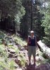
We turned off SR89 and onto Utah Scenic Highway 12 :next: https://www.scenicbyway12.com/ . This was a treat for the first time (finally). Red Canyon gave us a hint of the “eye-candy” yet to come. Stopped at one of the pull-outs along SR12 and hiked the Red Canyon Loop :next: [ photoset ] and a section of Golden Wall Trail :next: [ Golden Wall - Castle Bridge - Buckhorn Loop ] plus some connector trails (Red Canyon Tunnel Trail and Photographers Trail) :next: https://www.utah-trails.com/Tunnel-Trail and https://www.utah-trails.com/Golden-Wall ... orn-Trails

We eventually wandered into our “pet friendly” basecamp at the Best Western Ruby's Inn in Bryce Canyon City located just north of the park entrance :next: https://www.rubysinn.com/ and https://www.rubysinn.com/bryce-canyon-h ... hotos.html . This certainly was an international gathering of German, French, and Japanese tourist! After fixing a quick dinner at our basecamp hotel room, needed to stretch those legs around the Lake Loop :next: [ Ruby's Inn Lake Loop ] .
_______________________________________
Sunday June 1st
10.71 miles and 780 AEG (78 floors) on FitBit
84 miles on F-150

Bryce Canyon NP :next: https://www.nps.gov/brca/parknews/uploa ... 14-web.pdf

Pets in Bryce Canyon NP :next: https://www.nps.gov/brca/planyourvisit/pets.htm
"Pets are only permitted in campgrounds, parking lots, paved roads, paved viewpoint areas, and on the paved trail between Sunrise Point and Sunset Point"

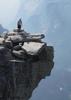
We knew the limited hiking with dog options within the national parks before we left for Bryce and Zion. Undeterred, the Bryce “eye-candy” made up for any missed opportunities :next: [ Bryce Canyon National Park Trails ] . The Sunrise Point to Sunset Point Rim Trail :next: [ Sunrise Point to Sunset Point Rim Trail ] offered our first glimpse of the Amphitheater Region. Lynn and I then took turns minding the dogs up on top of the rim to give us each a chance to hike the Navajo and/or Queen’s Garden Loops. See :next: [ Navajo Loop ] and [ Queen's Garden Trail ] .

Bryce Amphitheater Region map :next: https://www.nps.gov/brca/planyourvisit/ ... er-web.pdf
Fairyland Point
Sunrise Point
Sunrise to Sunset Point paved connector trail is dog friendly Sunset Point Inspiration Point Bryce Point

Bryce Southern Scenic Drive viewpoint map :next: Swamp Canyon, Whiteman Bench, Natural Bridge, Agua Canyon, Ponderosa Canyon, Black Birch Canyon, Rainbow Point & Yovimpa Points

I had scouted up the Bristlecone Loop :next: [ Bristlecone Loop ] that connects Rainbow Point and Yovimpa Points as a “photo op”. Unfortunately the trail was closed…

On the drive back from the southern reaches of Bryce Canyon, we stopped at Fairyland Point. Lynn and the dogs stayed at the rim top while I ventured down the Fairyland Loop Trail :next: [ Fairyland Loop Trail ]

With the hour approaching 6pm and knowing we still had a couple of hours daylight left, we agreed to head the F-150 over to Kodachrome Basin SP :next: https://stateparks.utah.gov/park/kodach ... state-park located 7 miles off Highway 12 near Cannonville on Cottonwood Canyon Road :next: https://stateparks.utah.gov/sites/state ... erview.png . I had previously viewed Kodachrome Basin from the south on an approach heading north up Cottonwood Canyon Road. On that occasion we had to abort our trip due to slick mud. This time I had an opportunity to view Kodachrome Basin from within the basin – nice! Pre-trip suggestions indicated Angels Palace or Shakespeare's Arch as highly recommended destinations :next: https://stateparks.utah.gov/sites/state ... ochure.pdf and https://www.trailpeak.com/trail-Kodachr ... le-UT-5584 . Hiked Angel’s Palace Trail :next: [ Angel's Palace Trail ] followed by an aborted attempt of Shakespeare’s Arch :next: [ Shakespear Arch ] prior to a sundown picnic dinner at TH parking lot. Arrived back at Ruby's Inn basecamp to catch Hawks-Kings game and Game of Thrones...
_______________________________________
Monday June 2nd
6.61 miles and 150 AEG (15 floors) on FitBit
245 miles on F-150

Zion NP :next: https://www.nps.gov/zion/index.htm
1hr 44min drive per Google Maps from Ruby's Inn to Zion Lodge
Zion 2014 park map and guide :next: https://www.nps.gov/zion/planyourvisit/ ... MG2014.pdf

Once again we knew the limited hiking with dog options within the national parks before we left for Bryce and Zion. Dogs are allowed on Pa'rus Trail :next: [ Pa'rus Trail - Zion ]
Trail connects Canyon Junction and Zion Visitor Center. Prior to entering the 1.1 mile long Zion – Mt Carmel tunnel on SR9, it was recommended to us to make a stop at the Canyon Overlook Trail :next: https://www.zionnational-park.com/zion- ... -trail.htm and https://www.utah.com/nationalparks/zion ... erlook.htm and [ Error H NAME ] Once near the Zion Visitor Center, I managed to grab the last available parking spot and we headed out along the Pa’rus trail as mid-morning temperatures hit the mid-80’s. With the scene reminding us too much of Sedona (the bad, not the good), we agreed to head up into the mountains and cooler climate along a back road I had scouted up as “Plan B”. Kolob Terrace Road was identified as an alternative since Zion Canyon can only be accessed by shuttle vehicles (no dogs allowed) :next: https://www.takemytrip.com/07zion/07_08a.htm .
We had a pleasant lunch up at Lava Point :next: https://www.nps.gov/zion/planyourvisit/ ... ground.htm and [ Lava Point Overlook - Zion NP ] before checking out the West Rim TH :next: https://www.nps.gov/zion/planyourvisit/ ... -trail.htm and Kolob Reservoir :next: https://wildlife.utah.gov/hotspots/deta ... 1154730183 and [ Kolob Reservior Loop Trail ] .
_______________________________________
Tuesday June 3rd
8.25 miles and 500 AEG (50 floors) on FitBit
572 miles on F-150

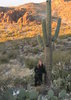
“Getaway Home Day” via a natural curiosity, Coral Pink Sand Dunes State Park :next: https://stateparks.utah.gov/park/coral- ... state-park and https://stateparks.utah.gov/sites/state ... alpink.jpg and https://www.zionnational-park.com/sdhike.htm and [ Coral Pink Sand Dunes ] . We discovered colonies of rare Tiger Beetles (only 600-3000 total population of beetles) while hiking the dunes :next: https://stateparks.utah.gov/sites/state ... ochure.pdf and were also treated to a fascinating display of late spring flowers while hiking the Nature Trail :next: https://www.duneguide.com/sand_dune_gui ... l_pink.htm . South Fork Indian Canyon Pictographs - Located 4 miles northeast of the dunes in the Mosquith Mountain Wilderness Study Area (WSA) :next: [ Mosquith Mountain WSA Trails ] . From Hancock Road – Yellow Jacket Road intersection, drive 3.5 miles passing the Ponderosa Campground until you reach the intersection of Hancock Road and the 4WD Sand Spring Road on the right. A 4WD vehicle allows travel within .5 mile of the pictographs. If your vehicle will not make it on the soft sandy roads, walk from the "T" in Hancock Road and Sand Dune Spring Road. It is 4 miles, one way, to the pictographs. Take Sand Springs Route to first intersection. Then a little less than 2 miles the trail ends and hiking trail to pictographs and petroglyphs begins. From the parking area, walk northeast to locate a path of use through the sand. Continue the gradual descent down the obvious trail. The trail soon becomes obvious as it continues east and then switches direction after a small drop down through the rocks. Continue descending and then traversing the hillside beneath the cliff band on hikers left. Shortly you will arrive at the (chain-link fence protected) South Fork Indian Canyon Pictographs. The distance from the parking lot to the pictographs is about .5 mile and the descent is about 150'. The pictographs sit at the back of a large alcove and pictures must be taken from behind the fence 30' away :next: https://www.zionnational-park.com/moquith-mountain.htm and https://www.zionnational-park.com/image ... ndex32.htm . This area is a unique hidden gem – highly recommended (and no HAZer has visited this place before?)!

Pipe Springs National Monument :next: https://www.nps.gov/pisp/index.htm and [ Ridge Trail - Pipe Springs ] .

North Rim of Grand Canyon :next: https://www.nps.gov/grca/planyourvisit/cg-nr.htm and https://www.nps.gov/grca/planyourvisit/ ... im-Map.pdf

Prior to our visit we knew about limited options hiking with dogs at the Grand Canyon North Rim; “Dogs on the North Rim; are not allowed other than the Bridle Trail (Greenway) that connects the lodge with the North Kaibab Trail and the portion of the Arizona Trail that continues north from there to the park entrance.”

Bridle Trail on HAZ :next: [ Bridle Trail ]
Bright Angel Point Trail on HAZ :next: [ Bright Angel Point Trail ]
Transept Trail on HAZ :next: [ Transept Trail ]

Made a stop at the Marble Canyon Navajo Bridge and found “condor city” :next: [ Marble Canyon Overlook at Navajo Bridge ] before stopping in Flagstaff for a late dinner. Arrived back home just before midnight…
___________________________
HIKING SUMMARY
7.44 miles, 390 AEG Saturday
10.71 miles, 780 AEG Sunday
6.61 miles, 150 AEG Monday
8.25 miles, 500 AEG Tuesday

TOTAL = 33.01 miles, 1820 AEG, 24 HAZ trails
141 images on iPhone
310 images on Canon Rebel XT
438 images on Canon 6D
61 images on Canon 7D

TOTAL = 950 images on 4 cameras...
F-150 SUMMARY
442 miles driving Saturday
84 miles driving Sunday
245 miles driving Monday
572 miles driving Tuesday

TOTAL = 1343 miles on F-150 (20.8 mpg). Assuming $3.80 per gallon average, that’s 64.5 gallons consumed for a trip cost of $245.35…
EDITORIAL COMMENT; Coffee in Utah sucks. Maybe that’s too rash since I didn't stop and try the Cafe Adobe/Expresso Rock Shop in Hatch UT... Took a Starbucks “fix” in Flagstaff to return me to equilibrium!

That NPS annual pass comes thru again for $25 entry into Bryce, Zion, Grand Canyon, plus $8 for Pipe Spring...

Aiming for Fall colour redux at Bryce Canyon Lodge the 1st week of October (looks like only Oct 4-6 or Oct 18-21 availability)? Cabin rentals are $212 per night plus multiple convenience fees and surcharges. Want to get some sunrise/sunset "golden hour" images...

PS - I see this trip tripped me over the 3K distance line for miles logged on HAZ :y:

LINKED HIKES;

Glen Canyon Dam :next: [ Glen Canyon Dam ]
Paria Movie Set :next: [ Paria Movie Road ]
Red Canyon Loop :next: [ photoset ]
Golden Wall :next: [ Golden Wall - Castle Bridge - Buckhorn Loop ]
Ruby’s Inn Lake Loop :next: [ Ruby's Inn Lake Loop ]

Bryce Canyon NP Trails :next: [ Bryce Canyon National Park Trails ]
Sunrise Point to Sunset Point Rim Trail :next: [ Sunrise Point to Sunset Point Rim Trail ]
Navajo Loop :next: [ Navajo Loop ]
Queen’s Garden Loop :next: [ Queen's Garden Trail ]
Bristlecone Loop :next: [ Bristlecone Loop ]
Fairyland Loop Trail :next: [ Fairyland Loop Trail ]
Angel’s Palace Trail :next: [ Angel's Palace Trail ]
Shakespeare Arch Trail :next: [ Shakespear Arch ]

Canyon Overlook Trail, Zion NP :next: [ Error H NAME ]
Pa’rus Trail :next: [ Pa'rus Trail - Zion ]
Lava Point Overlook, Zion NP :next: [ Lava Point Overlook - Zion NP ]
Kolob Reservoir Loop :next: [ Kolob Reservior Loop Trail ]

Coral Pink Sand Dunes State Park :next: [ Coral Pink Sand Dunes ]
South Fork Indian Canyon Pictographs :next: [ Mosquith Mountain WSA Trails ]
Pipe Springs NP Trails :next: [ Ridge Trail - Pipe Springs ]
Bridle Trail, Grand Canyon North Rim :next: [ Bridle Trail ]
Bright Angel Point Trail :next: [ Bright Angel Point Trail ]
Transept Trail, Grand Canyon North Rim :next: [ Transept Trail ]
Navajo Bridge, Marble Canyon :next: [ Marble Canyon Overlook at Navajo Bridge ]

Sent from my iPad
:)
 Geology
 Geology [ checklist ]
[ checklist ]  Sand Dune
 Culture
 Culture [ checklist ]
[ checklist ]  HAZ Gear  HAZ Rides
wildflower observationwildflower observationwildflower observationwildflower observationwildflower observation
Wildflowers Observation Moderate
Concentrated around Bryce Canyon NP and Coral Pink Sand Dunes SP
_____________________
 
May 25 2014
avatar

 Routes 29
 Photos 1,548
 Triplogs 1,802

49 male
 Joined Jan 25 2009
 Phoenix, AZ
Bryce Canyon National Park TrailsSouthwest, UT
Southwest, UT
Hiking avatar May 25 2014
Dave1Triplogs 1,802
Hiking16.04 Miles 1,800 AEG
Hiking16.04 Miles
1,800 ft AEG
 no routesno photosets
1st trip
Partners none no partners
_____________________
 
Jun 25 2013
avatar

 Routes 1
 Photos 29,248
 Triplogs 1,448

45 female
 Joined Jan 18 2011
 In the Wild
Bryce Canyon National Park TrailsSouthwest, UT
Southwest, UT
Hiking avatar Jun 25 2013
LucyanTriplogs 1,448
Hiking8.70 Miles
Hiking8.70 Miles   3 Hrs      2.90 mph
 no routes
Linked   none no linked trail guides
Partners none no partners
_____________________
 
Oct 16 2012
avatar

 Photos 31
 Triplogs 24

female
 Joined May 15 2008
 Phoenix, AZ
Bryce Canyon National Park TrailsSouthwest, UT
Southwest, UT
Hiking avatar Oct 16 2012
technologyTriplogs 24
Hiking
Hiking
 no routesno photosets
1st trip
Linked   none no linked trail guides
Partners none no partners
Views are amazing!
_____________________
We are what we believe we are.
C. S. Lewis
 
Mar 27 2011
avatar

 Guides 1
 Routes 11
 Photos 691
 Triplogs 94

45 female
 Joined May 14 2008
 Tucson, AZ
Bryce Canyon National Park TrailsSouthwest, UT
Southwest, UT
Hiking avatar Mar 27 2011
SaraeTriplogs 94
Hiking3.50 Miles
Hiking3.50 Miles   1 Hour      3.50 mph
 no routes
1st trip
Linked   none no linked trail guides
Partners none no partners
A quick side trip to see a bit of Bryce Canyon in the snow. Slipped and slid down the trail, saw the sites, tried to create little tiny avalanches, took lots of pictures, and had a bunch of fun in general. Sunset to Sunrise and back via Queens Garden.
_____________________
In every walk with nature one receives far more than he seeks. ~John Muir
 
Sep 05 2010
avatar

 Photos 18
 Triplogs 38

46 female
 Joined May 13 2010
 Scottsdale, AZ
Bryce Canyon National Park TrailsSouthwest, UT
Southwest, UT
Hiking avatar Sep 05 2010
Daydreamer21Triplogs 38
Hiking1.50 Miles
Hiking1.50 Miles   1 Hour      1.50 mph
 no routesno photosets
1st trip
Linked   none no linked trail guides
Partners none no partners
Short hike along the rim from Sunset Point to Inspiration Point and back. Twilight in the amphitheater was pretty impressive. The pictures I took don't do it justice.
_____________________
 
average hiking speed 2.07 mph
1, 2  Next

WARNING! Hiking and outdoor related sports can be dangerous. Be responsible and prepare for the trip. Study the area you are entering and plan accordingly. Dress for the current and unexpected weather changes. Take plenty of water. Never go alone. Make an itinerary with your plan(s), route(s), destination(s) and expected return time. Give your itinerary to trusted family and/or friends.

helpcommentissue

end of page marker