username
X
password
register
for free!
help
ArticlesGuidesRoutes
 
Photosets
 
 Comments
triplogs   photosets   labels comments more
Cienega Spring Trail #145 - 9 members in 25 triplogs have rated this an average 3.6 ( 1 to 5 best )
1, 2  Next
25 triplogs
login for filter options
Sep 24 2023
avatar

 Guides 107
 Routes 249
 Photos 2,067
 Triplogs 514

male
 Joined Nov 18 2005
 Phoenix, AZ
Cienega Spring Trail #145Globe, AZ
Globe, AZ
Hiking avatar Sep 24 2023
nonotTriplogs 514
Hiking18.00 Miles 4,000 AEG
Hiking18.00 Miles
4,000 ft AEG
 no routesno photosets
1st trip
Spent an enjoyable weekend in the Sierra Anchas.

Cienega trail is a good warmup before the climb up to McFadden Horse Mountain. I enjoyed the prime pine forest up top and wandered all the way to the overlook. Unfortunately a great deal of fog and low hanging clouds disrupted the scenic view. I spent time wondering whether the Native Americans that lived in the fort had any fear of heights.

Nobody seems to report the number of easily accessible/explorable mines along the Cienega trail. I peeked into a few but they all looked very mazelike, and a few had collapsed areas, so I didn't explore very far.

The McFadden Horse Mountain trail appears to get so little use that there is no discernable trail up top on the forest floor, but the Forest service appears to have constructed hundreds of cairns to try to keep you on track. While I thought at first the cairns were excessive, I still managed to lose the trail several times, usually where fallen trees had covered the cairns, so I appreciated all the effort they had put in.

The next day I headed up Reynold's creek and summited Center mountain and did a good deal of the way down the other side towards Lucky Strike, but turned around due to time concerns before reaching the intersection. I also wandered to the Dry Tank near the top of the mountain, and true to name, it was basically dry except a little mud in the middle.

On the way back I took the "other" Center mountain trail back to the Reynold's Creek trail. Both Center Mountain trail options have drawbacks. The lower trail is significantly overgrown. The upper trail is eroding and has several enormous fallen trees that completely block the trail. I can't recall both limboing while doing a monkey bar traverse before, but that is what it took to get through one section.

More flowers were observed along Reynold's creek trail than others.
wildflower observationwildflower observationwildflower observationwildflower observationwildflower observation
Wildflowers Observation Light

water 1 out of 5water 2 out of 5water less than maxwater less than max Cienega Spring Quart per minute Quart per minute
Maybe 2 liters per minute. The hose to the tank appears clogged but the tank itself had a bit of water in it, and the entire ground around was soaked. The spring cistern at the source was overflowing.

water 1 out of 5water less than maxwater less than maxwater less than max Reynolds Creek Falls - Sierra Ancha Pools to trickle Pools to trickle
A trickle flowing over the falls. Below the falls there were a few stagnant pools as the water appeared to go underground.

water 1 out of 5water 2 out of 5water less than maxwater less than max The Switchbacks Spring Quart per minute Quart per minute
A slight flow was observed in the creekbed. Maybe a liter per minute.
_____________________
http://hikearizona.com/garmin_maps.php

Hike Arizona it is full of sharp, pointy, ankle-twisting, HAZmaster crushing ROCKS!!
Hike Arizona it is full of sharp, pointy, shin-stabbing, skin-shredding plants!
Hike Arizona it is full of striking, biting, stabbing, venomous wildlife!
  1 archive
Jun 08 2022
avatar

 Guides 44
 Routes 162
 Photos 24,784
 Triplogs 2,417

75 male
 Joined May 04 2004
 Mesa, AZ
Cienega #145 McFadden Horse #146, AZ 
Cienega #145 McFadden Horse #146, AZ
 
Hiking avatar Jun 08 2022
CannondaleKidTriplogs 2,417
Hiking8.10 Miles 2,416 AEG
Hiking8.10 Miles   4 Hrs   45 Mns   1.80 mph
2,416 ft AEG      15 Mns Break20 LBS Pack
 no routes
1st trip
Partners partners
trixiec
Hike #4 of 4 from our Sierra Ancha 2022 camping/hiking trip.

The original plan before our trip was to hike the McFadden Horse Trail all the way to Elephant Rock overlook as we did 6 years ago.

However, since we had just pulled up stakes from our camp up at Billy Lawrence we figured we'd just stop at the Cienega Trail/Forest Road #145 intersection and hike the same route we last hiked just a week shy of 7 years ago. With the added distance from Cienega we decided to skip the trip out to Elephant Rock and just hit summit and return.

Of course, by following this route along FR #145 (which is now open to vehicular travel again) we would get another chance to visit the uranium mines along the way. Looking at my photos from 7 years ago very little of the mines has changed, the most notable being only one piece left of the original half-dozen rusted corrugated metal sheets which had been covering the largest of the mine entrances.

As usual, Tracey waited outside while I went in solo. Just inside a couple adits I was greeted by the sound of what appeared to be a swarm bees but was just a bunch of flies, which thankfully just moved away without bothering me. Being almost scrupulously clean there really wasn't anything worthy to highlight other than my EMF meter sounding a warning at the entrance to one mine.
(In later research , as long as one did not spend days and days in the same location the milliGauss readings were not high enough for any long-term danger... I hope)

Moving on...
Now on McFadden Horse Trail we began the slog to the top. After while on the ascent Tracey wondered aloud why there weren't any switch-backs... only for a few to appear, not that it made things much easier. But no matter, soon it eased off and we were in the shade for most of the way to the summit. We found a nice viewpoint just west of the summit with a nice view of Jack Mountain as well as the more distant Boneyback and Greenback peaks. With shade, a scenic view and a breeze we had the perfect lunch spot.

On the return trip we stopped by the only mine we had missed on the way up... how we missed it was a mystery to both of us as it was actually the largest, where the corrugated sheets used to be.

Back to the trailhead Tracey wandered over to the Cienega Creek water tank to rinse her out her neckerchief and called over for me to "check this out!" and sure enough it was worthy of another 100 foot walk to get a few photos of three spotted toads hanging around the tank. One was perched on the pipe Tracey had just rinsed her neckerchief in the water running from it without disturbing the toad.

And that wraps up our 2022 trip into the Sierra Ancha.

At four years since our last camping trip in the Sierra Ancha we both felt it had been too long so hopefully we won't wait that long again, but at a time a bit cooler than this trip... it was getting into the warm end for Tracey, but for me, heck I'm out in the triple digits almost every day. As long as the humidity single-digits/teens with a breeze and I'm wearing wicking gear from head-to-toe and keep everything damp it's all good.
 Fauna
 Fauna [ checklist ]
[ checklist ]  Red Spotted Toad
_____________________
CannondaleKid
 
Apr 24 2021
avatar

 Guides 99
 Routes 1,487
 Photos 16,091
 Triplogs 1,377

male
 Joined Jan 07 2017
 Fountain Hills,
Horsing Around in the Sierra Ancha, AZ 
Horsing Around in the Sierra Ancha, AZ
 
Hiking avatar Apr 24 2021
DixieFlyerTriplogs 1,377
Hiking10.20 Miles 2,897 AEG
Hiking10.20 Miles
2,897 ft AEG
 
I decided to go horsing around in the Sierra Ancha Wilderness yesterday, and what better place to horse around than McFadden Horse Mountain!

I first did an out-and-back hike by taking the McFadden Horse Mountain Trail all the way to its end at a scenic overlook. Along the way I went off trail for a short distance to the McFadden Horse Mountain Highpoint.

There had been some trail maintenance done since I was out there a year ago -- there is no more deadfall on the trail from the TH to the McFadden Horse Trail-Cienega Spring Trail Junction. There were 3-4 downed trees on the trail as I headed up the mountain, but the fallen trees were small ones that were very easy to step over. The trail is easy to follow and there are lots of large cairns along the trail.

Once on the top of the mountain, the trail is very delightful to hike on as there are hardly any rocks and you are walking on soft pine needles for the most part. Views at the summit are obstructed so there is not much to see. I do not believe that there is a benchmark disk at the summit.

The best part of the hike is from the summit to the overlook. There is some nice geology and great views at the overlook. I thought about trying to go from the overlook to Elephant Rock Arch, but decided against it as I wasn't sure how far I would have to descend to make my way over to the arch. I may go to the Arch from the other direction on a future hike, and explore getting from the arch to the overlook.

The descent down the mountain was nice because there were nice views of the Mazzies in front of you all the way down.

I enjoyed this hike and I will have to do it again.

On the way back to Phoenix we turned on FR 487 and hiked up to Aztec Peak. I started to drive all the way to the top, but decided to park a half mile or so before getting to the summit, and at least make a little bit of a hike out of it. It was a nice day and we enjoyed the views at the summit.

Mileage and elevation gain for the 2 hikes is below.
McFadden Horse Mountain: 8.7 miles; AEG of 2,602 feet
Aztec Peak: 1.5 miles; AEG of 295 feet

Stats above are the sum of the two
_____________________
Civilization is a nice place to visit but I wouldn't want to live there
 
Oct 25 2019
avatar

 Guides 48
 Routes 510
 Photos 9,555
 Triplogs 578

79 male
 Joined Dec 28 2006
 Scottsdale, AZ
Cienega Spr Tr #145 Explore - Sierra Ancha, AZ 
Cienega Spr Tr #145 Explore - Sierra Ancha, AZ
 
Hiking avatar Oct 25 2019
GrasshopperTriplogs 578
Hiking3.00 Miles 750 AEG
Hiking3.00 Miles   5 Hrs      0.60 mph
750 ft AEG
 no routes
1st trip
Linked   linked  
Partners partners
Oregon_Hiker
Sometimes it's nice to have a day of hiking with no end result in mind.
Today was one of those fun and easy hike days
.. and ..
doing so we had time to chat with ideas to solve a couple of the worlds greatest problems
:D
 Named place
 Named place [ checklist ]
[ checklist ]  Cienega Spring

water 1 out of 5water 2 out of 5water less than maxwater less than max Cienega Spring Quart per minute Quart per minute
_____________________
(Outside.. "there is No Place Like It!!")
  4 archives
Oct 25 2019
avatar

 Guides 9
 Routes 473
 Photos 8,433
 Triplogs 626

79 male
 Joined Dec 07 2010
 Phoenix, AZ
Cienega Spring Explore - Sierra Ancha, AZ 
Cienega Spring Explore - Sierra Ancha, AZ
 
Hiking avatar Oct 25 2019
Oregon_HikerTriplogs 626
Hiking3.00 Miles 750 AEG
Hiking3.00 Miles   5 Hrs      0.60 mph
750 ft AEG
 
1st trip
Linked   linked  
Partners partners
Grasshopper
Grasshopper and I went on this hike out of Camp GH on FR235 to explore the area around Cienega Spring. We hiked a half mile down FR235 to the spring from our camp and then went a short distance up the Cienega Spring Trail #145 which follows an old mining road, FR145. We explored off trail up a couple of drainages that flow down off the south facing slope of McFadden Horse Mtn in to a small basin on their way down to Reynolds Creek. Then we returned to the old mining road and hiked along it to check out 5 of the 12 adits of the in-active Rosa Asbestos mining claims strung out along FR145.

The Rosa Asbestos mining claims were originally located in the 1920s. The claims passed through several owners. No productions figures are available but as of 1956 productions had been minor. No production is known since 1956. (Info from US Bureau of Mines Report - Mineral Investigation of the Sierra Ancha Wilderness ...). We only found one of the 5 adits we were looking for but weren't real motivated because these were more like small prospects to look for asbestos rather than active mines.

While we were hiking on the old mining road, FR145, we were passed by a group of several large side-by-side ATVs. They never returned so I assume they were able to drive on FR145 all the way from Cienega Spring to HW288. That surprised me because it appeared on Google Earth that this road was washed out in at least one area after the Juniper Fire which started in May 2016.
_____________________
 
Nov 12 2017
avatar

 Photos 1,217
 Triplogs 206

68 male
 Joined Aug 04 2006
 Mesa, AZ
Cienega Spring Trail #145Globe, AZ
Globe, AZ
Hiking avatar Nov 12 2017
hikemonkTriplogs 206
Hiking6.40 Miles 1,614 AEG
Hiking6.40 Miles
1,614 ft AEG12 LBS Pack
 no routes
1st trip
Linked   none no linked trail guides
Partners none no partners
Interesting day. Walked right by a trail sign that was partially hidden by a bush and ended up missing the intended hike and doing a different hike along some old jeep or mining roads. Found these very interesting mines and climbed around in them a bit, all the time wondering what anyone could have been pulling out of them. Got home and did some research... apparently, they were asbestos mines... I hate it when that happens :-( ... I did however, trip across the interesting rock pictured with this photo set, which first caught my attention as it protruded from the ground and at first glance, resembled a vertebrae. (had a great dinner at Antlers Restaurant in Young!)
_____________________
  1 archive
Sep 18 2017
avatar

 Photos 356
 Triplogs 44

62 male
 Joined Apr 11 2011
 Mesa, AZ
Cienega Spring Trail #145Globe, AZ
Globe, AZ
Hiking avatar Sep 18 2017
CraigbhikinTriplogs 44
Hiking3.20 Miles 807 AEG
Hiking3.20 Miles
807 ft AEG
 no routes
Linked   none no linked trail guides
Partners none no partners
Did not have much time to hike the trail, I manly went up for spring water for a beer I want to brew. I first stopped at Workman Creek area and picked 40 pounds of apples for some jelly. I got to the spring to find very little water coming out of the hose. In trying to get water for my next beer, I needed to find a good water source. I found the problem, the hose was broken about 25 feet up from the tank. Someone before me patched it up with some first aid tape and a small tube, but the tape was all coming off. All I had was electrical tape, so I did the best I could to patch it up.
_____________________
Craigbehikin
  1 archive
Aug 27 2017
avatar

 Guides 6
 Photos 346
 Triplogs 225

69 male
 Joined May 13 2002
 Tempe, AZ
Cienega Spring Trail #145Globe, AZ
Globe, AZ
Hiking avatar Aug 27 2017
hikeazTriplogs 225
Hiking3.20 Miles 807 AEG
Hiking3.20 Miles   1 Hour   40 Mns   1.92 mph
807 ft AEG
 no routesno photosets
1st trip
Linked   none no linked trail guides
Partners none no partners
Apt description... Done as a shuttle. North parking is at MP 288 of SR288. McFadden sign is small and nondescript, be alert.
Took a Geiger counter but was dismayed how few 'hot' rocks we found - even in/around the mines. :?
wildflower observationwildflower observationwildflower observationwildflower observationwildflower observation
Wildflowers Observation Light
_____________________
"The censorship method ... is that of handing the job over to some frail and erring mortal man, and making him omnipotent on the assumption that his official status will make him infallible and omniscient."
George Bernard Shaw
 
Jun 02 2017
avatar

 Photos 356
 Triplogs 44

62 male
 Joined Apr 11 2011
 Mesa, AZ
Cienega Spring Trail #145Globe, AZ
Globe, AZ
Hiking avatar Jun 02 2017
CraigbhikinTriplogs 44
Hiking3.20 Miles 807 AEG
Hiking3.20 Miles
807 ft AEG
 no routes
Linked   none no linked trail guides
Partners none no partners
Another trip up to Cienega Spring just to get out, and enjoy a nice day. Also get more water to brew beer. Just a thought to other hikers, would it seem too much to take my jeep along this road? There are lots of 4X4 trails already, and I have second thoughts of blasting through here making another.
_____________________
Craigbehikin
 
Apr 29 2017
avatar

 Guides 94
 Routes 842
 Photos 22,068
 Triplogs 1,994

52 male
 Joined Sep 18 2002
 Tempe, AZ
McFadden Horse Trail #146Globe, AZ
Globe, AZ
Hiking avatar Apr 29 2017
chumleyTriplogs 1,994
Hiking8.96 Miles 2,644 AEG
Hiking8.96 Miles   4 Hrs   21 Mns   2.21 mph
2,644 ft AEG      18 Mns Break
 
1st trip
Linked   linked  
Partners partners
John9L
Karl told me we could see Elephant Rock Arch from this side. Well, maybe not.

Fire had taken its toll on the ascent, but the top of the mountain was either untouched or looked the way a managed burn should look with no crowning. We took the time to find the actual highpoint despite there being no benchmark. The summit area is quite flat and the highest point marked on the topo is not the highest when you're there. No sign of a cairn or anything to signify the high point either. Oh well.

The views off the rim are worth the price of admission. It's great up here.

On the descent it started snowing on us. I didn't believe it at first. It wasn't that cold. It had been 47 when we started and was 58 when we finished. I'd guess it was in the low 50s when the flurries hit. Probably the warmest I can recall for seeing falling snow. It was very light and only lasted a couple of minutes. Still cool.

Drove over to Aztec to see the falls and the summit. The tower is officially closed to visitors now with a nice fence and shiny new razor wire. Two day use sites were hosting large group campouts. If I had to guess, these are the people who will start the next fire.

water 1 out of 5water 2 out of 5water less than maxwater less than max Workman Creek Falls Light flow Light flow
water report recorded in the field on our app Route Scout
_____________________
I'm not sure what my spirit animal is, but I'm confident it has rabies.
 
Apr 29 2017
avatar

 Guides 6
 Routes 183
 Photos 5,612
 Triplogs 1,647

male
 Joined Mar 12 2004
 Scottsdale, AZ
McFadden Horse Trail #146Globe, AZ
Globe, AZ
Hiking avatar Apr 29 2017
John9LTriplogs 1,647
Hiking8.96 Miles 2,644 AEG
Hiking8.96 Miles
2,644 ft AEG
 no routesno photosets
1st trip
Linked   linked  
Partners partners
BrunoP
chumley
Headed out to the Sierra Ancha with Chumley and BrunoP. We planned on car camping and wanted to do a couple of hikes over the weekend. We made the drive up Saturday morning and started with McFadden Horse Mountain. I've seen pics of this one and thought it looked interesting. This turned out to be a solid hike with amazing views!

We parked off Hwy 288 and started the hardy climb up the Cienega Spring Trail. The old road climbs and climbs as you make your way through the forest. There are several large sections of burn. We continued on and connected onto the McFadden Horse Trail. This trail continues climbing through a burn section. With much effort we topped out and took a short break to water Bruno. Views were wonderful!

Once up top it's very easy going along the mostly flat mesa as you head through the unburnt forest following a series of large cairns. We both really enjoyed this section and cruised through as we wrapped around and headed north. The views are impressive as we arrived at the viewpoint for the hilltop ruin. It's recessed off McFadden and looks difficult to access. From scoping it out there is a route down on the left(west) side of the mesa. You then need to traverse and climb the NW corner. Looks very intriguing! Maybe another time.

After lunch we started our return and cruised back. Along the way we detoured to the high point but couldn't find a summit cairn. This mountain doesn't need one. From there we started our descent down the switchbacks. The trail is in good condition with minimal deadfall. It's easy going as long as you watch your step. In time we arrived back at the truck and headed out in search of a campsite.

This was a great hike that I'm glad we hit. It's quality hiking with solid views. The hilltop ruin looks very cool and I'd love to return to see it up close.
_____________________
  1 archive
Apr 22 2016
avatar

 Photos 356
 Triplogs 44

62 male
 Joined Apr 11 2011
 Mesa, AZ
Cienega Spring Trail #145Globe, AZ
Globe, AZ
Hiking avatar Apr 22 2016
CraigbhikinTriplogs 44
Hiking3.20 Miles 807 AEG
Hiking3.20 Miles
807 ft AEG
 no routes
Linked   none no linked trail guides
Partners none no partners
In the area exploring, and thought I would check out the trail. Did not finish it, but plan to go back again and make a day of it. Nice hike with great views of Reynold’s Creek, a must do. Brought back spring water for a beer I want to brew.
 Culture
 Culture [ checklist ]
[ checklist ]  HAZ Decal  HAZ Rides
 Named place
 Named place [ checklist ]
[ checklist ]  Cienega Spring  Reynolds Creek
wildflower observationwildflower observationwildflower observationwildflower observationwildflower observation
Wildflowers Observation Light
_____________________
Craigbehikin
 
Apr 15 2016
avatar

 Routes 1
 Photos 150
 Triplogs 35

58 male
 Joined Nov 03 2008
 QC AZ
McFadden Horse Trail #146Globe, AZ
Globe, AZ
Hiking avatar Apr 15 2016
Carioca43Triplogs 35
Hiking12.00 Miles 2,184 AEG
Hiking12.00 Miles
2,184 ft AEG
 no routes
Partners none no partners
It was good to get out on a backpacking trip again. I picked up a pretty serious bronchial infection in February and it really slowed me down.

I did this with my Scout Troop 838 We are prepping for a Grand Canyon Trip so we keep building miles and difficulty. I really love Elephant Rock so this fit the bill I had 3 adults and 12 kids.

The steep beat me up I was the last to make to camp on the top of the Mcfadden Horse MT. In the morning we got up early and booked it out to the Rock. I love the hike on top then to meet the spectacular views of the Cherry Creek Wilderness. Kids did pretty good I had some first timers that I actually beat out but the more experienced ones are learning and doing great. Will post photoset later, just trying to catch up on logs
_____________________
  4 archives
Sep 19 2015
avatar

 Guides 264
 Routes 2,799
 Photos 14,514
 Triplogs 5,896

55 male
 Joined Nov 20 1996
 
McFadden Super Loop, AZ 
McFadden Super Loop, AZ
 
Hiking avatar Sep 19 2015
joebartelsTriplogs 5,896
Hiking20.40 Miles 4,300 AEG
Hiking20.40 Miles   10 Hrs   18 Mns   2.19 mph
4,300 ft AEG   1 Hour    Break14 LBS Pack
 
1st trip
Redo of Bruce's masterpiece plus Cienega #145.

McFadden Horse Trail
Most will rate this lower due to the steep approach. The forest up top, eastern and Elephant Butte views win me over.

Elephant Rock Arch
Bridged the gap connecting McFadden to Elephant Rock. Shorts are fine, took under a half hour. We stopped above the arch then headed down. 1 class four downclimb. Ironically I climbed up it last time out of curiosity. I couldn't figure out the downclimb last time so I jumped 10? feet. Got the twist move on the first try this time then did it again for fun. Fairly certain you could backtrack a bit to avoid the obstacle.

McFadden Peak
Just a road walk up. Impressive views of the thick mogul berber carpet of pines.

Park McFadden Trail #55
Majority of this is an old road down to Circle Ranch. Without using Hank's track I would have missed where it leaves the road for awhile. The cairns at each end are faint and the trail is faint for that segment. Found a tank and added to the map. From Circle Ranch down it's a nice trail. The upper isn't bad but most would prefer the lower part.

Cienega Spring Trail #145
Just a road. A little closer and personal views such as from McFadden Peak.
 Fauna
 Fauna [ checklist ]
[ checklist ]  Teva
 Named place
 Named place [ checklist ]
[ checklist ]  Elephant Rock Arch - Sierra Ancha

water 1 out of 5water 2 out of 5water 3 out of 5water 4 out of 5 Cienega Spring Gallon + per minute Gallon + per minute
water report recorded in the field on our app Route Scout Super fresh clear

_____________________
- joe
 
Sep 19 2015
avatar

 Guides 4
 Routes 491
 Photos 10,890
 Triplogs 1,257

55 male
 Joined Nov 20 2012
 Phoenix, AZ
McFadden Super Loop, AZ 
McFadden Super Loop, AZ
 
Hiking avatar Sep 19 2015
BiFrostTriplogs 1,257
Hiking20.48 Miles 4,391 AEG
Hiking20.48 Miles   10 Hrs   18 Mns   2.20 mph
4,391 ft AEG   1 Hour    Break
 no routes
1st trip
Joe put together a great loop that was derived from an earlier trip to Elephant Arch. We hiked up McFadden Horse Trail from Hwy 288 to get to the arch gaining 1600 feet right from the start. Once on top we had excellent views traversing out to the arch with this area definitely the highlight of the loop. Just the approach to the arch was half the fun negotiating the rocky cliffs and great views. We took a nice break at the arch before heading downhill and another traverse towards McFadden Peak.

On the road to McFadden Peak the views again were excellent and the tower was in good shape. Spent some time checking it out with birds eye view of the entire range. Coming off the top we picked up the Park McFadden Trail and followed this down several miles to Circle Ranch and Reynolds Creek area. Lots of shade on the way down with impressive stands of ponderosa and large oaks. We crossed Hwy 288 and headed up another road following Reynolds Creek for a few miles.

We finished off the day looping around to Cienega Spring which was nice surprise. The spring box was feed by a pipe with very clean looking water and cool meadow area. From there we followed Cienega Spring Trail to close the loop from where we started early in the morning.
 Geology
 Geology [ checklist ]
[ checklist ]  Natural Arch
_____________________
  2 archives
Sep 05 2015
avatar

 Routes 268
 Photos 2,969
 Triplogs 541

66 male
 Joined Aug 16 2009
 Mesa,AZ
McFadden Loop, AZ 
McFadden Loop, AZ
 
Hiking avatar Sep 05 2015
hikerdwTriplogs 541
Hiking11.79 Miles 2,717 AEG
Hiking11.79 Miles   5 Hrs   39 Mns   2.54 mph
2,717 ft AEG   1 Hour    Break
 
1st trip
Nice hike in the Sierra Ancha's. Started from the Reynolds TH and headed out on trail #55, then went off-trail to pick up FR 2770, then uphill on trail #146 where we enjoyed lunch and then took a walk to the high point of McFadden Horse Mountain. From there we headed back down the hill where we picked up trail #145 which took us by a few old mines. Checked out Cienega spring which was flowing very nice, and then closed out the loop with a nice stroll along FR's 235/410.

Highlights were the blackberries we enjoyed on trail #55 just a .25 mile from the start, the top of McFadden Horse Mountain, and trail #146. Heck, I enjoyed the entire hike :D

water 1 out of 5water 2 out of 5water 3 out of 5water less than max Cienega Spring Gallon per minute Gallon per minute
Very nice flow from the pipe and the trough was over flowwing.
_____________________
Expect to self rescue
 
Jul 20 2014
avatar

 Guides 27
 Routes 670
 Photos 12,111
 Triplogs 857

56 male
 Joined Jul 05 2006
 Mesa, AZ
Reynolds Center Lucky 235 410, AZ 
Reynolds Center Lucky 235 410, AZ
 
Hiking avatar Jul 20 2014
DarthStillerTriplogs 857
Hiking10.70 Miles 2,200 AEG
Hiking10.70 Miles   6 Hrs      1.78 mph
2,200 ft AEG
 no routes
1st trip
We did the Center Mountain Trail from the Reynolds Creek TH and decided to go back on the forest roads 235 and 410 instead to make it a loop instead of an out-an-back. I also wanted to scope out FR235 to see what condition it's in to drive to the Billy Lawrence TH.

The Center Mtn. Trail is really very nice. :y: Starts out with ponderosa pines and then climbs to the top of Center Mtn, giving really nice views of Cherry Creek. We saw the trail to Murphy Ranch on the way to the top. Funny that there's a trail marker there and no trail is shown on any maps. Looks like a plan for a hike for another day. :wrt:

At the Billy Lawrence TH, we saw 2 guys who drove up to there and arrived at the same time we did. I asked them about the condition of FR235 and they told it was pretty brutal. Our hike down it gave us a very different impression. Still not sure if they were just being sarcastic with us. :-k

On the way back down FR235 to FR410, we decided to hike the one section of the Cienega Trail we didn't finish last summer on our McFadden Horse Trail Hike :bdh: . alex recognized a spot he was sure we walked thru. Once I got home and downloaded the track, we were 9 yards short of completing the whole trail :tt: ](*,) Oh well :oplz: . Close enough.

Finished up the hike by 3pm and got back home before 6pm. Long drive home :zzz: . temps were nice, hotter than the forecast, but still cooler than Phoenix. Shade and breezes helped out alot.
 Culture
 Culture [ checklist ]
[ checklist ]  Mine Shaft
 Named place
 Named place [ checklist ]
[ checklist ]  Elephant Rock
_____________________
 
Jul 12 2014
avatar

 Guides 44
 Routes 162
 Photos 24,784
 Triplogs 2,417

75 male
 Joined May 04 2004
 Mesa, AZ
McFadden Horse Trail #146Globe, AZ
Globe, AZ
Hiking avatar Jul 12 2014
CannondaleKidTriplogs 2,417
Hiking8.30 Miles 2,516 AEG
Hiking8.30 Miles   5 Hrs   13 Mns   1.67 mph
2,516 ft AEG      15 Mns Break25 LBS Pack
 no routes
1st trip
Partners partners
trixiec
Monsoon season be damned, Tracey wanted to go somewhere a bit cooler than the Valley so we headed off to the Sierra Ancha. A quick scan through all my GPS routes of future hikes along with some we had already done, we figured we'd hike McFadden Horse Mountain out to the Elephant Rock ruin overlook, which we did last year from Cienega Spring, only this time we'd hike it from the trailhead on AZ 288. This route would save about 3 miles of hiking at the expense of a very steep climb right from the beginning.

An early 2 hour drive and even with my usual messing around we were on the trail shortly after 8 am. While the temperature was mid-70's, the early morning humidity made it feel more like 120°, and within a mile I was drenched with sweat from head to toe. We would be almost to the summit before I could walk more than a few hundred yards without having to stop and wring out my skullcap due to sweat running into my eyes.

Thankfully there was a light breeze along the ridge so this part of the hike became a breeze. Along the ridge we came across an area where everything had been cut close to the ground with chainsaws cordoned off with pink tape, which gave me the feeling it had been an emergency helicopter landing zone.

At the end of the ridge we took the usual photos of the ruin on Elephant Rock. We wandered around a bit and dropped down to see if there was a possible route across, but alas, having neither the right equipment or rock climbing skills, we realized it was past our capabilities. Between that and the requisite Sierra Ancha afternoon thunderstorm moving in we had to hit the trail. Ok, so we had a quick PB&J lunch to provide enough energy for the return trip.

On the way back, instead of following the trail in the wide arc near the summit we cut across where I had drawn a track of what had been a trail probably some 50+ years ago. While we only found a few spots where there may have been a trail, most of the time we followed game trails.

While the ascent had been brutal with the high humidity, the descent was even worse, at least for me. My left knee was still ailing but even using hiking poles and taking it slow, the jolting eventually radiated the pain into my hip and the last mile or so down to the trailhead were agony. I would much rather climb a steep ascent than descend at the end of a hike when I'm tired and weary.

But we made it back just in time for the thunderstorm to roll in, building and following us on the drive back toward Globe. We had just turned onto 188 from 288 when we got hit with waves of rain almost horizontal across, threatening to blow us off the road. It was bad enough Tracey wondered if I should pull off the road (I was driving her Honda Fit) but with it looking even worse we continued. Then the hail hit. Thankfully the hail wasn't big enough to cause any damage. As we approached the north exit to Wheatfields Road the rain stopped abruptly but the wind picked up and Wheatfields wash area was completely engulfed in a dust storm which continued all along the drive into Globe.

From there our trip home was uneventful,which was a good thing because early this morning on the drive out the 60 past Peralta we hit a monstrous crow that either wanted to commit suicide or was too old to take off fast enough to avoid being hit. It didn't break the large (and expensive) headlight lens assembly, but the shock broke the filaments in the turn signal and the running bulbs, one below and the other above the headlight, which made it through unscathed.
 Flora
 Flora [ checklist ]
[ checklist ]  Century Plant
 Fauna
 Fauna [ checklist ]
[ checklist ]  Ladybug beetle
_____________________
CannondaleKid
 
Aug 17 2013
avatar

 Guides 4
 Photos 12
 Triplogs 3

39 male
 Joined Jul 25 2011
 Superior, AZ
Cienega Spring Trail #145Globe, AZ
Globe, AZ
Hiking avatar Aug 17 2013
bmbeardTriplogs 3
Hiking3.20 Miles 807 AEG
Hiking3.20 Miles   3 Hrs      1.07 mph
807 ft AEG
 no routesno photosets
1st trip
Linked   none no linked trail guides
Partners none no partners
I did this hike with 2 dogs from the Cienega Spring side hiking north to the junction with McFadden Trail. The spring provides the opportunity to get the dogs wet at start and end of the hike. Pretty easy gradient and nice views, but I decided to turn around for the heat on the dogs, as there are some exposed stretches in full sun. The mines along this old road are asbestos mines from the Rosa Group, not uranium. The adits are in the Mescal Limestone.

This would be a great trail run. Fairly wide, smooth trail, easy to run with others, and the spring.
_____________________
 
Jun 30 2013
avatar

 Guides 27
 Routes 670
 Photos 12,111
 Triplogs 857

56 male
 Joined Jul 05 2006
 Mesa, AZ
McFadden Horse Trail #146Globe, AZ
Globe, AZ
Hiking avatar Jun 30 2013
DarthStillerTriplogs 857
Hiking10.10 Miles 2,500 AEG
Hiking10.10 Miles   5 Hrs   30 Mns   1.84 mph
2,500 ft AEG
 no routes
1st trip
Linked   linked  
Partners partners
Alex
This hike probably has some of the best views of any hike I've done in the Sierra Anchases. Ted and Alex joined me for this one. I used to hike with Ted a lot more back in the days before I discovered HAZ and GPS, and subsequently our old hiking stories involve getting lost and other various misadventures that could have easily resulted in either one of our deaths. But I digress....

We started from the beginning of the McFadden Horse Trail off 288 just before 8am. This starts off the bat very steep. There are a few semi-less steep spots, but soon enough the loose rock keeps it interesting. We reached the trail junction quickly enough, and in fact almost walked past it since it's a little offset from the steady vegetative wall along the McFadden Horse/Cienega Trails.

After the trail junction we continued up McFadden Horse trail and it only gets steeper and looser, which brought back some PTSD memories of Leisure Canyon http://hikearizona.com/photoset.php?ID=17543. We pretend to take quick breaks to take pictures of the scenery as we ascended, but soon enough, we all stopped to breathe after awhile without pretenses of youth and physical fitness. We were all drenched in sweat and when we checked our thermometers thinking it would show how hot it already was even at this elevation, we saw that it was only 74 degrees.

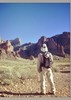
Soon enough it leveled off and the hike became much more pleasant. We had a level trail, shade, and a breeze. Things swung in the opposite direction very quickly. After a little while, the trial started to descend quite a bit until it leveled off again until we reached the endpoint, which was spectacular. We spent a good 20 minutes there taking pictures and taking in the scenery. I took out my NatGeo map at one point and we tried to identify some of the peaks we saw. A breeze almost blew my map away, so that didn't last too long. The rock outcroppings and cliffs at this point are many, and it's kind of dicey making your way around. a lot of the rocks have big cracks in them, making us all very apprehensive to not pull a Wile E. Coyote while trying to get that magic picture. At one point I wedged my walking stick into a crack in the rock and actually moved the one part of the rock, so while it looks pretty solid for the most part, we weren't taking anything for granted.

Our original plan was to try to also hike the Cienega Spring Trail, depending on time, temp, etc. Once we got back to the trail junction, Ted told us he was definitely not trying the extra 5 miles. I had the idea of giving him my car keys and having him meet us at the other TH. We had it all worked out until he informed us that he hasn't driven a standard transmission for over 30 years. oh well. instead, we decided to hike about a mile in on the Cienega Trail and head back. we got to the first uranium mine when Ted decided he was done. Alex and I hiked a mile in according to our odometers, which underestimate mileage. The final mileage for the hike was 10.1. Alex and I saw 3 mines total. After the extra "mile" mark, we both felt the heat kicking in and I could tell I was running low on water. We made it back to the car without incident and headed home.
 Named place
 Named place [ checklist ]
[ checklist ]  Elephant Rock
_____________________
 
average hiking speed 1.7 mph
1, 2  Next

WARNING! Hiking and outdoor related sports can be dangerous. Be responsible and prepare for the trip. Study the area you are entering and plan accordingly. Dress for the current and unexpected weather changes. Take plenty of water. Never go alone. Make an itinerary with your plan(s), route(s), destination(s) and expected return time. Give your itinerary to trusted family and/or friends.

helpcommentissue

end of page marker