username
X
password
register
for free!
help
ArticlesGuidesRoutes
 
Photosets
 
 Comments
triplogs   photosets   labels comments more
Grand Canyon Corridor Loop - 9 members in 16 triplogs have rated this an average 4.3 ( 1 to 5 best )
16 triplogs
login for filter options
Oct 21 2023
avatar

 Guides 59
 Routes 1,100
 Photos 1,191
 Triplogs 1,290

male
 Joined Jan 01 2023
 Arizona
Grand Canyon Corridor LoopNorthwest, AZ
Northwest, AZ
Backpack avatar Oct 21 2023
pseudalpineTriplogs 1,290
Backpack47.16 Miles 10,311 AEG
Backpack47.16 Miles3 Days         
10,311 ft AEG
 
1st trip
Route Scout Route Recorded  on Route Scout | Pop | Map | Popup | MapDEX
Yaki Point to Cottonwood Campground, The Transept (lower), Upper Ribbon Falls, Old Bright Angel Trail (SRim), BM 3702 and The Battleship area.
 Named place
 Named place [ checklist ]
[ checklist ]  Ribbon Falls
  7 archives
Jul 30 2023
avatar

 Guides 2
 Routes 21
 Photos 64
 Triplogs 7

male
 Joined Oct 30 2024
 Kenilworth, NJ
R2r2r, AZ 
R2r2r, AZ
 
Backpack avatar Jul 30 2023
ckoss_Triplogs 7
Backpack54.16 Miles 11,311 AEG
Backpack54.16 Miles2 Days   9 Hrs   50 Mns   
11,311 ft AEG20 LBS Pack
 
1st trip
The 2nd of 3 Grand Canyon backpacking trips for 2023.

Preface
As college students, the best time for vacation was during the summer, which can be brutal in the canyon. My hiking partner was only available in late July for their first trip to GC. I previously did a R2R in 2017. We decided on South Kaibab - North Kaibab - Bright Angel with 2 nights at Cottonwood Campground. We had 2 interesting encounters in the early morning of Day 3.

Day 1 - Lemonade and Ribbon Falls
The first Hikers' Express shuttle arrived arrived at 4 AM to take us to the South Kaibab TH. Today was ~14 miles from the TH to Cottonwood. We topped off our water and headed down the canyon by headlamp. The shelter at the Tipoff enticed us to stop and have a quick break, followed by crossing the black bridge. We made it to the Canteen right at 8 AM and enjoyed a few cups of lemonade before entering the Box section of North Kaibab. We also collected out passport stamps at the Ranger Station. After an hour or so in the Box, we decided to cool off in the Bright Angel creek by laying down in a shallow section and it was very relieving to escape the intense heat. Around noon we crossed the creek to visit Ribbon Falls before arriving to camp. We thought about visiting Upper Ribbon Falls, but we were content with our time with the lower falls. We arrived at Cottonwood at 1 PM and collected our passport stamps and above us was a thermometer in the shade reading 102F. We spend the rest of the day eating food and enjoying the creek.

Day 2 - North Rim
The plan for today was to keep our tents and other non-essential gear at our campsite at Cottonwood as we ascend to the North Rim and visit the Visitor Center for the passport stamps. We started down the trail at 5 AM followed by a quick break at Manzanita to fill up water and sketch a doodle on the chalk board. We had to wait for the bathrooms to be finished cleaning before using them. It was fascinating seeing all of the equipment to perform the trail repairs due to the rock slides earlier that year. There were several steel cables spanning across the canyon nearby. We also spotted a fresh pipeline fracture across the canyon from North Kaibab trail where the water was gushing out spraying against the canyon wall. As we were nearing the final ascent to the Coconino Overlook, a nearby horse escaped a tour group and the wrangler shouted to us to grab it, which we were able to stop it! We made it to the TH at 11 AM and debated on stopping at the gas station store or just to proceed to the lodge and visitor center. There is no shuttle on the North Rim like the South Rim and we debated on asking to hitch-hike, but being from NJ we have never done that, so we just followed the path to the lodge. We collected our stamps, enjoyed the views, inhaled lunch at the deli, and started back down North Kaibab at 4 PM. I have not been to the North Rim since 2017 and I completely forgot the powerful moment of seeing the San Francisco Peaks above the South Rim. I thought it was interesting that visitation to Roaring Springs is off limits now as I remember in 2017 that we could take the side trail to the base of the springs. Luckily it was partly cloudy today so the temperature at Cottonwood was only 90F when we arrived back at 7 PM.

Day 3 - Strange Encounters
Since this was the first time for my hiking partner to visit the corridor trails, I splurged and reserved breakfast at the Canteen for late seating (6:30AM) so we woke up at 3 AM to complete the ~7 miles to make it on time. The moon was very bright and lit up the canyon, but we still hiked with headlamp. On the way to Phantom Ranch, we observed a skunk on the side of the trail, a first for me. Soon after, we had another encounter. This time, a woman in a white dress was approaching us in the opposite direction with no headlamp. When we crossed paths, she appeared to have no pack or gear. We were very confused and we asked if she was okay and where she was heading. We do not remember exactly recall, but I remember being confused because she said something along the lines of going to a meadow, which does not make sense to me. We arrived at the Canteen by 6AM, but the staff was able to feed us early since it was just the 2 of us for breakfast. My partner and I really enjoyed the meal and felt it was worth the money to receive all of the fresh food and calories considering our relatively aggressive itinerary for the time of the year. We crossed Silver Bridge at 7AM and making it to Havasupai Gardens before 10AM. Side note, we passed a mother/daughter descending North Kaibab on Day 2, they passed Cottonwood around 8PM with the plan to hike R2R through the night. We passed them again on the way to Havasupai Gardens and they looked exhausted. We took quick breaks at the 2 rest houses and made it to the TH at 2:30PM. Until next time in November.

water 1 out of 5water 2 out of 5water 3 out of 5water less than max Bright Angel Creek Medium flow Medium flow

water 1 out of 5water 2 out of 5water less than maxwater less than max Phantom Creek Light flow Light flow

water 1 out of 5water 2 out of 5water less than maxwater less than max Ribbon Falls Light flow Light flow

water 1 out of 5water 2 out of 5water 3 out of 5water 4 out of 5 Roaring Springs Gallon + per minute Gallon + per minute

water 1 out of 5water 2 out of 5water less than maxwater less than max Wall Creek Light flow Light flow
 
Jan 29 2022
avatar

 Routes 27
 Photos 279
 Triplogs 56

39 male
 Joined Aug 06 2009
 Phoenix, AZ
Grand Canyon Corridor LoopNorthwest, AZ
Northwest, AZ
Hiking avatar Jan 29 2022
nathanbriskTriplogs 56
Hiking14.77 Miles 4,357 AEG
Hiking14.77 Miles   9 Hrs   39 Mns   2.18 mph
4,357 ft AEG   2 Hrs   53 Mns Break
 
no photosets
1st trip
Partners none no partners
Route Scout Route Recorded  on Route Scout | Pop | Map | Popup | MapDEX
Not too much ice, but there was an icy wind. SK to Tonto to BA
_____________________
 
May 16 2021
avatar

 Routes 61
 Photos 1,008
 Triplogs 224

44 male
 Joined Aug 19 2009
 The Basin
Grand Canyon Corridor LoopNorthwest, AZ
Northwest, AZ
Hiking avatar May 16 2021
survivordudeTriplogs 224
Hiking19.50 Miles 4,975 AEG
Hiking19.50 Miles   10 Hrs   3 Mns   2.77 mph
4,975 ft AEG   3 Hrs    Break
 
Solo dolo down SK, 2.5 hours to the river. Swim at the beach for an hour. The canyon runner population has exploded. I love the river trail, its so easy going. Hot slog up to IG for about an hour break/siesta. Lots of wildlife. About 3 hours up to the top. Good to see all the youth out enjoying the outdoors. Quads were toast at the Coconino. Definitely slower than my last time up BA, but I did go to the river this time and it was a longer hike, so there's that. I enjoyed taking my time with this one.
 Named place
 Named place [ checklist ]
[ checklist ]  Grand Canyon National Park
_____________________
“There is nothing that exists outside the thought of the immediate moment.”
 
Aug 23 2019
avatar

 Routes 137
 Photos 1
 Triplogs 105

44 female
 Joined Oct 21 2016
 Tempe, AZ
Grand Canyon - Inner Gorge - AZT #38Northwest, AZ
Northwest, AZ
Hiking avatar Aug 23 2019
MAPTriplogs 105
Hiking20.50 Miles 6,688 AEG
Hiking20.50 Miles2 Days   13 Hrs   48 Mns   
6,688 ft AEG
 
no photosets
1st trip
Day 1: First in line for the hikers' express shuttle at the Bright Angel Lodge by 3:45 am! One other person ended up showing at that stop. :lol: Different experience from the past (maybe because it's August). On SK trail by 4:40 am. Sunrise, around an hour later, was indescribable. Got to Phantom Ranch around 9 am and took a quick snack break. First time up North Kaibab and we were immediately blown away with the extreme beauty when we entered "the box". It was warm but actually a pretty perfect temperature at that time. We took another break at one of the creek crossings to filter cold creek water and cool down. Met the 2nd park ranger of the day who was giving hikers heat-hiking advice. Those rangers must deal with a lot. :-k We continued on and hit the Ribbon Falls creek trail sign around 11:30 am. It was getting pretty darn hot at that point and Ribbon Falls was the PERFECT oasis to cool down at. The hike to the falls took us about a half-hour. The distance is super short but there are many trails and some are more reasonable than others to follow. Ribbon Falls is out of this world beautiful! We had the place completely to ourselves for two hours while we played in the little cave and relaxed behind the falls. With our water bladders filled and our body temps cooled, we decided to head out and break at each of the (approximately) mile and a half spaced campgrounds ahead. There were a couple other waterfalls we stopped at to make use of the cold water and one with a great freezing cold pool close to the Manzanita Ranger Station. Waived hello to Roaring Springs falls around 5 pm and kept plugging away up the ever increasing grade. From here the side canyon we were heading up, paralleling the rock outcropping the north rim lodge sits on, kept getting prettier and prettier. As the sun went down the colors reflected in the canyon seemed to continuously change. The final few miles of N Kaibab are RELENTLESS! :sweat: Holy moly! Darkness was lovely and I had little bat friends flitting around to keep me company as the vegetation turned to forest forest. I made it to the top around 8:30 pm thinking my two friends were close behind. It was freeeeezing at the top and I immediately put on every piece of clothing I had. My friends arrived about a half hour later and one was feeling pretty bad & ended up throwing up. Unfortunately she had stopped consuming electrolytes once the sun went behind the canyon walls and didn't think about how much she was still sweating. I convinced her to eat some of my saltstick chewables and we made it to the lodge. :y:

Day 2: Woke up in our adorable little cabin feeling surprisingly good! We spent the day leisurely walking around the north rim and of course hitting up the lodge for food food and more food. Loved all the delicious vegan options offered for all three meals at the lodge! :DANCE: Our one friend who experienced heat exhaustion the previous evening ended up securing a spot on the shuttle for the return trip the next day instead of hiking back with us. We were grateful she had that option at the last minute and happy she was feeling better.

Day 3: We got to the N Kaibab TH at 4 am and started our decent. It was cool but more pleasant than the evening of our arrival. We got to the bridge around 5:30 am and light was starting to really expose the canyon colors. Stopped briefly to appreciate the colors in the caves area but no breaks this time around. I'm not going to lie...my calves were tight and my knees were screaming pretty loudly during the entire decent. Up is definitely my preference! We entered "the box" around 10 am (an hour later than our way in) and felt the heavy humid air sucking the energy out of me fo sho. Got to Phantom Ranch around 11:30 am and bought some cups of ice to add to our bladders and took our first break. Stayed for about a half hour and headed out with the intention of stopping at each resthouse area to cool down. Next stop was the beautiful little beach near the Colorado River Resthouse. We met a large family who hiked down just for the day to cook out & hang. They had multiple grills, leftover onions, potatoes, etc. They had packed it in and they were packing it all out (as we all should but unfortunately people don't always). Impressive! Now for the final stretch. We stopped at Indian Gardens around 3 pm and filtered cold water for the last time and cooled down. Heading up Bright Angel...I will never get over that view with the light streaming in and illuminating the angel. No words. The Bright Angel switchbacks feel like cake compared to the North Kaibab switchbacks. Still, our bodies were pretty exhausted at this point and we were moving pretty slowly. It's fun encountering tourists who have only hiked down a mile and a half and don't seem to understand they are blocking the entire trail for exhausted hikers who can't deal with navigating them right now. :lol: My friend made it to the top just before me and was treated to the sight of two mountain goats standing on a rock with a ray of light shinning on them! I saw the picture but missed the goats. Still, I was extremely happy for her to have had such a special treat!
_____________________
  1 archive
May 18 2019
avatar

 Routes 61
 Photos 1,008
 Triplogs 224

44 male
 Joined Aug 19 2009
 The Basin
Grand Canyon Corridor LoopNorthwest, AZ
Northwest, AZ
Hiking avatar May 18 2019
survivordudeTriplogs 224
Hiking19.44 Miles 4,973 AEG
Hiking19.44 Miles   10 Hrs   10 Mns   2.42 mph
4,973 ft AEG   2 Hrs   8 Mns Break
 
_____________________
“There is nothing that exists outside the thought of the immediate moment.”
 
Sep 11 2015
avatar

 Guides 8
 Routes 12
 Photos 1,918
 Triplogs 662

39 female
 Joined Dec 02 2009
 Grand Canyon
Grand Canyon Corridor LoopNorthwest, AZ
Northwest, AZ
Hiking avatar Sep 11 2015
HippyTriplogs 662
Hiking47.00 Miles 5,975 AEG
Hiking47.00 Miles   36 Hrs      1.31 mph
5,975 ft AEG
 no routesno photosets
1st trip
Rim to Rim to Rim
SK to skeleton PT, down old Miners to the Tonto platform, down the kickass tapeats break to the river trail, across black bridge to Phantom, lemonade, down to the silver bridge, up and over "the kiva route" to the lower section of Utah Flats Route, back to Phantom, more lemonade, up NK to the rim, 4 hour nap, down NK to Cottonwood, 2 hour nap, no lemonade :( , down to Ribbon Falls, back to Phantom Ranch, still no lemonade!! It's dark, they're closed...on we March... Cross silver bridge, up old corkscrew, cross new BA at granite pools, up old BA to the Tonto, sneak into Indian Gardens, nap 2 hours? near Creek, up BA to Kolb Seep, left trail on "Kolb Route", intersect Upper Old BA aka Cameron Route, emerge just east of upper tunnel, quazi nap right there, crawl to original Trailhead beside Kolb Studio... No margaritas... Taxi took forever to get us home.

Sleeping for the next three weeks...except work at 8am tomorrow.... Meeehhhhhh
_____________________
Canyon Freak Adventures!
 
May 23 2015
avatar

 Routes 29
 Photos 1,548
 Triplogs 1,802

49 male
 Joined Jan 25 2009
 Phoenix, AZ
Clear Creek Trail - GCNPNorthwest, AZ
Northwest, AZ
Backpack avatar May 23 2015
Dave1Triplogs 1,802
Backpack45.00 Miles 11,400 AEG
Backpack45.00 Miles3 Days         
11,400 ft AEG
 no routes
Saturday: Hiked down South Kaibab then took the Clear Creek Trail over to CC. Light rain on/off all day.

Sunday: Hiked up to Cheyava Falls (dry) and a little beyond. Checked out some other side canyons and did a little bit of exploring. Light rain at times.

Monday: Hiked out from CC. Rain in the morning. Sunny and hot by the time we got to Phantom Ranch. Hiked out Bright Angel.
_____________________
 
Oct 26 2012
avatar

 Photos 1,217
 Triplogs 206

68 male
 Joined Aug 04 2006
 Mesa, AZ
Grand Canyon Corridor LoopNorthwest, AZ
Northwest, AZ
Backpack avatar Oct 26 2012
hikemonkTriplogs 206
Backpack25.00 Miles 5,350 AEG
Backpack25.00 Miles4 Days         
5,350 ft AEG
 no routes
1st trip
Partners none no partners
_____________________
 
Oct 03 2011
avatar

 Triplogs 3

57 male
 Joined Aug 13 2011
 Chandler, AZ
Grand Canyon Corridor LoopNorthwest, AZ
Northwest, AZ
Backpack avatar Oct 03 2011
PrizbullTriplogs 3
Backpack30.00 Miles 11,498 AEG
Backpack30.00 Miles3 Days   30 Hrs      
11,498 ft AEG45 LBS Pack
 no routesno photosets
1st trip
Spent 3 Days backpacking Grand Canyon via South Kaibab to Bright Angel Campgropund on Thursday morning. Very steep trail that I was not prepared for and over packed with close to 50 pounds. Took close to 7 hours to reach campsite. Rested that evening at Phantom Ranch with a couple beers. Friday morning headed out to Ribbon Falls up North Kaibab Trail. Great photos along the way (soon to come)and at the falls. Somewhat remote locate to reach falls so still in good condition and not abused by tourists. That added 12 miles to our excursion. Saturday morning packed up before sunrise and headed out over silver bridge and up Bright Angel. This was easier to me even though it was farther. I would rather use muscles on Bright Angel than joints on South Kaibab. It took us 12 hours breaking regularly but great scenery and photo ops. Totaled 29 miles in 30 hours over 3 days. This was an adventure of a lifetime and we are planning again for the same time of year cause the weather was perfect. South rim was high 78 and low of 45. Phantom Ranch was high 93 and low of 66. Mostly cloudy at bottom so the sun was not beating on us constantly. Loved the trip and met a lot of great people along the way.
_____________________
 
Apr 17 2011
avatar

 Guides 22
 Routes 6
 Photos 512
 Triplogs 466

34 male
 Joined May 17 2007
 CA
Grand Canyon Corridor LoopNorthwest, AZ
Northwest, AZ
Hiking avatar Apr 17 2011
rally_toadTriplogs 466
Hiking16.00 Miles 5,749 AEG
Hiking16.00 Miles
5,749 ft AEG
 no routesno photosets
1st trip
Linked   none no linked trail guides
Partners none no partners
Great canyon trip. Stayed in the bunkhouse at Phantom for 2 nights, relaxed, enjoyed the river, played volleyball, enjoyed great meals, and even showered at the bottom of the canyon. The best of both worlds.

Great time catching up with some old friends and meeting new ones!!
_____________________
"Who are you guys??!!" -Farnsworth
 
Nov 17 2010
avatar

 Triplogs 17

48 female
 Joined Jun 15 2010
 Phoenix, AZ
Grand Canyon Corridor LoopNorthwest, AZ
Northwest, AZ
Hiking avatar Nov 17 2010
tiffhikerTriplogs 17
Hiking35.20 Miles 5,749 AEG
Hiking35.20 Miles
5,749 ft AEG
 no routesno photosets
1st trip
Linked   none no linked trail guides
Partners none no partners
_____________________
 
Nov 12 2010
avatar

 Guides 20
 Routes 13
 Photos 3,189
 Triplogs 451

female
 Joined Mar 31 2002
 Chandler, AZ
Grand Canyon Corridor LoopNorthwest, AZ
Northwest, AZ
Backpack avatar Nov 12 2010
desertgirlTriplogs 451
Backpack35.20 Miles 5,749 AEG
Backpack35.20 Miles4 Days         
5,749 ft AEG
 no routes
1st trip
Linked   none no linked trail guides
Partners none no partners
Friday 12th Nov: Hike down as part of loop backpack. Nice day to enjoy the crisp fall weather. Good to be out in the canyon ...
Sat 13th Nov: Day hike from the Ranch after BF. Easy hike - forded the creek to get to the Ribbon Falls ...hung out for about an hour in the cool spray ( got cold once the sun was gone). Beautiful place. On the way back we hit the bridge and looked for the trail to Upper Ribbon Falls, looks to be a fairly straightforward ramp to the saddle -- next time!
Monkey flowers are done ....beautiful fall colors in the drainage (Bright Angel). The area right before ribbon falls was full of fall color and some late blooming flowers ( mostly yellow!)
Sun 14th Nov: BF at the ranch & mosseyed up to Indian Gardens for camp ... skipped Garden Creek ( something to look forward to the next time I head down or up..). After catching some muchies at camp headed out for a quick turn to Plateau Point for catcing teh sunset. Met an interesting bird man along the way and saw some bush birds ...and traded tales of what to do in Clear Creek area.
Mon 15th: Up and out - The clouds finally showed up to make for some nice accents to the blue skies ...Indian Garden -- fall was just begining. Surprisingly warm ..... Fun to see the deer congregate on the bathroom deck in the wee hours of the morning. The clear skies made for some great star gazing at 3:00 am
 Fauna
 Fauna [ checklist ]
[ checklist ]  Bighorn Sheep
 Culture
 Culture [ checklist ]
[ checklist ]  Throwing a Wendy
foliage observationfoliage observationfoliage observationfoliage observationfoliage observation
Autumn Foliage Observation Light
wildflower observationwildflower observationwildflower observationwildflower observationwildflower observation
Wildflowers Observation Isolated
_____________________
 
Nov 12 2010
avatar

 Guides 21
 Routes 1,182
 Photos 36,858
 Triplogs 1,570

69 female
 Joined Feb 26 2004
 Phoenix, AZ
Grand Canyon Corridor LoopNorthwest, AZ
Northwest, AZ
Backpack avatar Nov 12 2010
tibberTriplogs 1,570
Backpack35.50 Miles 5,749 AEG
Backpack35.50 Miles4 Days         
5,749 ft AEG
 
1st trip
Partners partners
bigfoot
desertgirl
tiffhiker
writelots
We drove up late Thursday afternoon and met up with most of the group for a late Thursday dinner. The next morning, we got up to a crsipy temperature... you know, the credit card scraping of the windshield kind. After a nice warm breakfast, we went to the Backcountry Office, got the permit, loaded on the shuttle and we were off around 8:45AM.

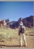
SOUTH KAIBAB is all its cracked up to be. At the top the trail was dusted with snow on the sides for the first mile or so and it was a bit nippy. However, I was glad to finally be heading down that big ditch everyone talks about. There were nine of us happily hiking down to the bottom stopping at each vista to share in the glorious views of the canyon. :DANCE: I do have to say, I was glad when we finally got to where the sun was shining and even tho we didn't have any Fraleys, the colors seemed intense and beautiful.

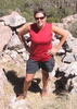
We encountered a trail crew just above Cedar Ridge. That's quite the process they have going on there plus they have to climb back out every day. However, what a place to have to spend your time earning your wage. Cedar Ridge really is lovely especially with O'Neill Butte in the foreground. We spent a little time here goofing around and enjoying the environs. Getting down to Skeleton Point was lots of fun as we switched back and forth. Along the way I encountered a group of squirrels including a very entertaining one right next to the trail.

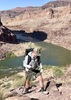
Once we got to Skeleton Point it was a bit windy and almost immediately Wendy calls out to me to come to where she is as she points out the mighty Colorado below and gave me some more information about the GC. Just before we started back down the trail to TipOff I said to Wendy, "I think I've done pretty good on this steep part of the trail." Wendy says, "but Angela, we haven't made it to the steep part yet". :o I gulped loudly and got very wide-eyed. Uh, oh.

Once again as we got toward the bottom of those switchbacks I was struck by the beauty of what I call the Grand Canyon plain, the Tonto Plateau. I was struck by its spaciousness as well as its simplistic beauty. Once we made it to the TipOff rest stop several folks put their packs down by where the mules are tied. I didn't like the idea of having to lift my pack all the way from the ground to my back so I went a little further and joined up with a couple of the guys who had found some nice rocks to sit on that were above the ground giving me a little more leverage to lift the pack on my back. The last couple days of the hike, I would get a lot better at the pack lifting. I was forgetting to use my knee to balance my pack before throwing it up on my back; that really helps.

From TipOff it is 1.8 miles to the Suspension Bridge with that last mile containing the steepest part of the 1,470 foot elevation drop. The initial part of the trail down the TipOff is pretty nice especially as you come on to Panorama Point. I even did a little movieing as I came out on the Point. Not too far from there, Karen spotted a couple Mountain Sheep (a mother and her young 'un) up on the canyon side just below a spire. They entertained us for awhile and even granted us an incredible photo opportunity as the mom stood high on a big rock on the cliff and looked down on us. Karen even got a photo of the young one as it jumped from one rock to the other. We considered ourselves very lucky to enjoy such a moment. :A1:

It was good to finally get to the Bridge. We took the obligatory "bridge" photos and made our way to the other side where the rest of the group was waiting not too far from there. Clyde had hiked ahead to get us the group site with the building structure. It was a great campsite... if it just hadn't been so cold. I was happy about the very nice restrooms with running water and of course, you can't go wrong with the Canteen.

RIBBON FALLS is even better in person; however it was not my original destination when I started hiking Saturday morning. I had planned to meet up with 2 other of the group and explore Phantom Falls but I decided it was too cold for that plus I was making excellent time so I continued down this amazing and easy trail along the creek anxiously waiting for the sun to get above the canyon walls. I wasn't sure what my goal was for this hike whether it was going to be time or mileage but I ultimately decided since I was rolling along pretty good, I would turn around at the 6.5 mile point so that I could claim my longest hike ever.

This hike takes you through some incredible terrain including a couple marshes. I was quite surprised by this. You hike near the creek or near the canyon walls or both crossing 4 bridges and from narrow to wide paths. I was delighted to eventually run into some fall color too. I stopped to have a little lunch before heading back and also shed some of my layers as the sun was now shining very nicely and of course the views were stunning. I had encountered about a dozen hikers coming and going. I was just so impressed with the fact that I, "tibber", was on the infamous North Kaibab trail at the bottom of the GRAND CANYON :D .

As I was just starting back, I saw Ambika in the distance. I hardly got to say hello and she says I'm going to Ribbon Falls with them as it's not too far away. I didn't put up much of a fuss 'cuz now that I knew how easy the trail was, I thot perhaps I could indeed make it to Ribbon. She and Guru took me under their wing and off we went. It's nice to hike by yourself but it's so much more fun to share this experience with others :) . After all, it IS the :worthy: GRAND CANYON.

We made good time and decided to try the creek crossing. After investigating a couple different possibilities, we went back to the first one. Guru crossed first and dropped his pack and cameras before coming back for the shorter-legged Ambika as a couple of the rocks were a bit far apart. Luckily, another hiker came along and provided an assist. He and his wife were from Canada. We sat next to them at breakfast the next morning. They were a delightful couple. Apparently they are working on her bucket list.

The trek to Ribbon once you cross the creek is fairly quick and as we got to the bottom of the Falls we encountered Wendy, Gary and Karen having their lunch. We had a quick bite to eat and then did our climb up and around the back and to the side of the Falls. Altho the light isn't the most cooperative, the Falls are really photographic. It was also nice to sit and just enjoy the scene for a few minutes while Ambika & Guru finished off their photography. We did our last glamor shots ;) and headed back around 1:45.

This time we opted for the bridge. The hill coming up from the bridge is not so bad. The rest of the hike was lots of fun as we enjoyed the amazing geology, flora including fall colors and the weather as well as each others company. We took a very leisurely pace arriving back at sunset (5:30ish). It was pretty neat to see a deer next to the Phantom Ranch sign. I was treated to a "wendy" special dinner when I got back to camp after completing my longest hike :gun: (16 miles according to Scout from campsite to Ribbon and back).

INDIAN GARDENS The next morning we didn't get on our way until 10:15. I was happy to have done Ribbon Falls the day before because now my muscles didn't seem so tight. --(Ambika gave me a very helpful hint and suggested toward the end of a hike - take nice big steps so that you can stretch your muscles. I ended up doing this a couple times and my muscles seemed to relax a little)-- The first thing out of the gate is crossing the Silver Bridge over the massive Colorado. It really is magnificent. I took a movie along the way. And then it was a matter of following the river for awhile before heading in the direction of the South Rim.

Not too long after we headed south, we saw a backpack and Tiffani informed us that Clyde was across the way at Garden Falls. After a very brief encouraging discussion 8-[ from Wendy, all 3 of us took off our packs and made our way down across the creek and up to the bottom of the Falls. Tiffani tried to go up the way Clyde had but wasn't none too pleased by the slick rock bed. Meanwhile Wendy had found a way up to the right and we gladly headed that way and made the short scramble up to the area where Clyde was waiting for us. This was a worthy short side trip as you got a lot of bang for your buck :budrose: . We hung out for about 1/2 hour or so before heading back to the trail.

Awh yes, the Devil's :x Corkscrew and all those steps was our next task. Clyde decided we should count each screw. There are 8 or 9 depending on where you consider the top.... anyway that made it fun and the time went by a little faster and before you knew it, we joined the group gathered along the trail near the top of Garden Falls. If you look to the Northeast from this area you can see one of those upward geological masses (rather than the horizontal lineage) that shows the lift in this particular part of the canyon. It really is cool looking.

We had a quick snack before making our journey through the incredible tree-lined creek of the Great UnConformity layer. What a layer! It really is something. There was a touch of fall color and some most impressive Cottonwoods along the way as you head up toward Indian Gardens campground. You also cross the creek a few times. The campsite is very nice and we pitched our tents under a large tree dressed for autumn.

PLATEAU POINT The mile and a half hike for sunset started at 4 o'clock. We moved at a pretty good pace and as usual, a couple of the hikers seemed like they sprinted to the Point as the rest of us hung back and grabbed some photos including of some deer along the way. The hike seems longer than 1.5 miles but fortunately the trail is pretty nice. We took tons of pictures of the Canyon, the River, the Landmarks, and each other before we sat down for our snacks, supper and/or beverages. Wendy sang us a couple songs and shortly after that, we made our way back to camp and finished off the nite with some libations (butterscotch schnapps and/or hot chocolate or oozo) :STP: and talk about the water table in Phoenix.

BRIGHT ANGEL TRAIL Ok, the part of this adventure we all didn't look forward to other than the scenery and reward at the top. I think we started around 8:30ish, others had left earlier, and made our way up the first mile and a half. About 1/2 way during this starting section I realized I was clippin' along pretty good and not feeling too wasted yet. Wendy, Guru, Ambika, Karen and I met up at the 3 mile house. I was pleased to know I had : rambo : conquered Jacob's Ladder in a satisfactory fashion. Some say that can be the worst part of this hike out so I'm thinkin', "not bad, not bad".

However, the last 2/3rds weren't any piece of cake. The steps seems like they are higher and the trail seems steeper. I didn't mind the mule trains from time to time either. The toughest part of the haul up to me was between the tunnels as now you hit some elevation and the trail is going up at more of an incline. I would have to take a couple more breaks ](*,) here as now the 40lb pack seemed to be getting heavier and this 3/4 mile trek seemed to go on forever. I couldn't stop very long though cuz my calves would start cramping. I guess this was a good thing as it kept me moving plus knowing we were so close to the top you could feel it.

It was glorious at the end just like it was in the beginning. :y: I was tired but exhilarated. I was pleased I FINALLY got to experience the Canyon like so many of the rest of you. I was always so envious. It's everything everyone says it is. I'm still feeling the soreness in my calves but I said to myself, the pain :yuck: would not matter on this one. We walked to get Tonto at the Backcountry Office and drove over to Bright Angel Lodge where we met up with the rest of the crew in the lounge and then had lunch shortly thereafter before our parting group photo outside of the lodge overlooking the canyon.

THOUGHTS: The ONLY lo-light were the nippy evening temperatures. I am making a little more progress about dealing with the cold like turning my buff into a hat, using the skinny car visor on the benches and below my sleeping bag and of course the sleeping bag liner.

Some Highlights - seeing the mom and kid mountain sheep above the S Kaibab; what a treat,
crossing both of those bridges I've seen so many times in photos,
walking along Bright Angel Creek and seeing Ribbon Falls in person,
getting over to Lower Garden Falls,
enjoying Plateau Point at sunset,
and last - completing the 8 miles in and 100 out :wlift: . I was glad we had cool temps for the climb out as I can only imagine how much harder it would have been with heat.

This was billed as a Beginners Backpack. Wendy :thanx: , as usual, was a great trip leader : queen : . I think it was wonderful to have several experienced backpackers along; especially those that had spent time in the Canyon as they could share so much and answer almost any question you might have plus they knew when to point out landmarks or would know if you were almost there yet :lol: .

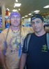
It was fun to hang out at the Canteen during the evening hours where we played Yahtzee (I shook a few, Wendy shook one on a "demo" but never during the games and Tiffani... well [-( ). Clyde : king : had the bestest booze as usual. The prime tequila made Wendy's renown Mango Tango cocktails even better. EVERYONE loved them.

I'm glad I have been able to do this and I do look forward to my next foray into the Grand Canyon. At the same time, I am saddened by the news of this week regarding GPSJoe. It kind of takes the edge off.

I will be adding short movie links in the next week. Heh I got them done this week:
Day One: South Kaibab Trail http://www.youtube.com/watch?v=NnmWHeuqIuQ
Day Two: N Kaibab Trail - along Bright Angel Creek to the 6.5 mile mark from the group campsite at Phantom Ranch toward Ribbon Falls http://www.youtube.com/watch?v=VsGPBUKy_ZI
Ribbon Falls and back to the group campsite at Phantom Ranch http://www.youtube.com/watch?v=deSxvEjQ-2w
Day Three & Four: Bright Angel Trail including walking across the Suspension Bridge, a trek over to Lower Garden Falls http://www.youtube.com/watch?v=uZ9l6o4XMOo
Plateau Point and a quick flick of a mule passenger train coming down Bright Angel: http://www.youtube.com/watch?v=jdFjAU8rv6w

The photos... well, that will be awhile.
 Flora
 Flora [ checklist ]
[ checklist ]  Sumac
 Meteorology
 Meteorology [ checklist ]
[ checklist ]  Moon
foliage observationfoliage observationfoliage observationfoliage observationfoliage observation
Autumn Foliage Observation Light
_____________________
For me, sometimes it's just as much about the journey as the destination.
Oh, and once in awhile, don't forget to look back at the trail you've traveled.
 
Nov 12 2010
avatar

 Guides 19
 Routes 40
 Photos 5,624
 Triplogs 341

52 female
 Joined Nov 22 2005
 Tucson, AZ
Grand Canyon Corridor LoopNorthwest, AZ
Northwest, AZ
Backpack avatar Nov 12 2010
writelotsTriplogs 341
Backpack38.20 Miles 5,749 AEG
Backpack38.20 Miles4 Days         
5,749 ft AEG
 no routes
1st trip
Partners partners
desertgirl
tibber
Took Angela (Tibber) along with 3 other canyon newbies and 4 experienced hikers on a fun little hike through my favorite giant hole in the ground. This trip was almost exactly a month after my Royal Arch adventure, and was SO remarkably different and still quite wonderful. Each day was filled with hiking, but it was always relaxing and comfortable - even in spite of the cold weather which blew in just a few days before our departure.

Once again, I was impressed by how nice the South Kaibab trail is without mules. It's the prettiest of the corridor trails, anyhow, but without the mules, it's pure delight! I hope they smart up and keep it this way (ha - like that'll happen).

Watching the faces of the newbies as they realized not only how massive the canyon is from the inside, but also how strong their own skills were has hikers was my favorite part. Everyone did amazingly well - I hardly had any babysitting to do at all. All but one of the newbies made it out to Ribbon Falls. In fact, Karen, Gary and I left Ribbon at 1:15pm and made it back to the canteen in time for 2 beers! I couldn't believe my watch when it said 3:20 -I don't ever think I've made that kind of time without feeling like I was trying! (Shows what a beer with a closing time at the end of the trail will do).

The campground and lodge were both full, but thanks to the weather turn the trails were never really crowded. I told Angela that I was sorry that her experience of the Canyon was less than complete - you really haven't hiked Bright Angel until you've had to fight off hordes of turons in flip flops! She seemed to think that she could live without that.

We got to spend time doing things I haven't gotten to do on many canyon trips - like exploring Garden Falls, eating dinner at Plateau Point and hitting BOTH happy hours at the Phantom Canteen. This slower pace and relaxed itinerary were just perfect not only for beginners, but for canyon die-hards who just need a little more time to love their favorite place.

Now... Lets see...when can I go back?
 Culture
 Culture [ checklist ]
[ checklist ]  Throwing a Wendy
_____________________
-----------------------------------
Change will not come if we wait for some other person or some other time. We are the ones we've been waiting for. We are the change that we seek.- Barack Obama
 
Jul 04 2008
avatar

 Routes 29
 Photos 1,548
 Triplogs 1,802

49 male
 Joined Jan 25 2009
 Phoenix, AZ
Rim to RimNorthwest, AZ
Northwest, AZ
Hiking avatar Jul 04 2008
Dave1Triplogs 1,802
Hiking45.00 Miles 11,000 AEG
Hiking45.00 Miles
11,000 ft AEG
 no routes
_____________________
 
average hiking speed 2.17 mph

WARNING! Hiking and outdoor related sports can be dangerous. Be responsible and prepare for the trip. Study the area you are entering and plan accordingly. Dress for the current and unexpected weather changes. Take plenty of water. Never go alone. Make an itinerary with your plan(s), route(s), destination(s) and expected return time. Give your itinerary to trusted family and/or friends.

helpcommentissue

end of page marker