|
| | | Round Valley Large Loop, AZ | | | |
|
|
Round Valley Large Loop, AZ
| | |
| |
|
| Hiking | 10.20 Miles |
1,487 AEG |
| | Hiking | 10.20 Miles | 3 Hrs 55 Mns | | 2.60 mph |
| 1,487 ft AEG | | | | |
|
|
| |
| Partners |
|
none
[ show ]
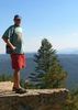
| no partners | | Looking for things to do in Payson, I hit on the idea of hiking the ridge line from the Phoenix St water tank to Gibson Peak, then returning on the jeep trail souhwest of the ridge line. The satellite view makes the first half look relatively brush free, while the second half would appears much denser. Topo view makes the southwest slope appear rather steep (about 800 feet in a half mile). So, before doing that hike, I thought I would research it by hiking out to the southeastern limit of the jeep trail, next to Gibson Peak's less dense southwest slope, then make a big loop of it by travelling down an old burn spur to Round Valley, then up some washes to the edge of the rez, then back to the TH, just for extra miles.
The drive up at 0600-0730 was very little traffic, as was the drive back from 1330-1500. I was surprised, as even on other week days, at the same time, traffic is heavier. (Though not as heavy as on weekends.) Maybe Wednesday is the best day for Payson travel?
The "trailhead" is a small road spur next to the Phoenix St water tank. There's no "no parking" signs, so I imagine it is legal to park there. You could get two cars in the space.
After passing through the fence, I climbed up HIll 5207, which showed evidence of many lightning strikes. (Burnt trees that did not start larger fires.) As elsewhere in the vicinity, underbrush was very mild and easily navigated.
After 5207, I dropped down to the main jeep trail, heading southeast. Despite the Payson to Round Valley Loop ( http://hikearizona.com/decoder=16287 ) description, I would not want to MTB it: Think of it as Elephant Mountain Trail with trees. (It is that rocky.) I continued down the jeep trail for several miles, through four up & down wash crossings, until reaching the burned spur. The jeep trail turned grassy, indicating lack of recent use.
The lower slope of Gibson Peak did not look steep at all. I shot some video ( http://youtu.be/lfdq6Ziq6nA ), then headed back to the burned spur.
I thought I would have to negotiate the sparse burn brush, but I actually found a jeep trail down. It finally stopped drizzling as I headed down the spur. It looks like the jeep trail goes all the way to the paved road, but I turned northwest across the top of the housing area. Holy cow, there is a ton of deer scat on the north slope of Hill 4954. I saw a couple of deer, but did not get a decent photo. After a mile of x-country travel, I hooked up with a jeep trail and basically followed that / a wash up towards the Tonto Apache rez.
Just south of the rez, by Noah's abandoned inboard ark, is a large meadow just stuffed with flowers. It was beauty and the beast, as there were also a lot of shotgun shells on the trail, and a garbage dump near the wood line.
I thought I was supposed to follow a jeep trail back, but there was a fence between me and it. I crossed over just before the open dirt area, which looked kind of like a park, as there were picnic tables, rough cabana and, oddly, a couple of wikiups (despite being off rez land, according to the topo). When I travelled far enough to see the Phoenix St water tank, I was on the wrong side of the fence. I must have missed whatever trail it was that would have kept me on the correct / south side of it.
-----
Long story short, Gibson Peak would not be unduly difficult, at least slope-wise, if you took the jeep trail up from Round Valley, then climbed the southwest slope. The Stewart Ridge ( http://hikearizona.com/decoder=16282 ) description claims the ridge route would require chaps, but based on my other hikes in the area, I'd have to see it to believe it, so travelling the ridge line also appears a viable option. |
|
Wildflowers Observation Light
|
|
| _____________________
| http://prestonm.com : Everyone's enjoyment of the outdoors is different and should be equally honored. |
| | |
|
|
|
 Route Editor


 ) Turned out to be about 3x that in AEG -- plus an extra 1.5 miles, but that was expected due to wandering and exploring.

