username
X
password
register
for free!
help
ArticlesGuidesRoutes
 
Photosets
 
 Comments
triplogs   photosets   labels comments more
P-Bar Lake Trail #326 - 5 members in 21 triplogs have rated this an average 3 ( 1 to 5 best )
1, 2  Next
21 triplogs
login for filter options
Jul 26 2025
avatar

 Guides 37
 Routes 556
 Photos 10,872
 Triplogs 1,052

43 male
 Joined Jan 21 2013
 AZ
Foote Creek Trail #76Alpine, AZ
Alpine, AZ
Hiking avatar Jul 26 2025
FOTGTriplogs 1,052
Hiking6.55 Miles 1,005 AEG
Hiking6.55 Miles   2 Hrs   54 Mns   2.34 mph
1,005 ft AEG      6 Mns Break
 
1st trip
Linked   linked  
Partners none no partners
Route Scout Route Recorded  on Route Scout | Pop | Map | Popup | MapDEX
I went back to the Foote Creek Trail to check on how far the trail had been cleared since recently discovering some trail maintenance east of P-Bar Lake.

Unfortunately, the trail was only cleared for about a half mile more than what I had hiked the previous week. The forest is not necessarily devastated where the trail maintenance ends, but the tread is very tough to find and there were no blazes. I only walked a short portion past the cleared trail before turning around and heading back. I did pass a few cairns and found some longer sections of tread on my way back. I was really hoping the trail maintenance had made it to the spring that I believe might mark where Foote Creek starts flowing, but it comes up a little short. Nevertheless, it was still an excellent little hike and I will probably come back to explore more of the uncleared trail one day. I have attached the route with the end of the trail maintenance marked.

water 1 out of 5water less than maxwater less than maxwater less than max P Bar Lake 1-25% full 1-25% full
_____________________
  1 archive
Jul 17 2025
avatar

 Guides 37
 Routes 556
 Photos 10,872
 Triplogs 1,052

43 male
 Joined Jan 21 2013
 AZ
P-Bar Lake Trail #326Alpine, AZ
Alpine, AZ
Hiking avatar Jul 17 2025
FOTGTriplogs 1,052
Hiking5.09 Miles 657 AEG
Hiking5.09 Miles   1 Hour   59 Mns   2.57 mph
657 ft AEG
 
Linked   linked  
Partners none no partners
Route Scout Route Recorded  on Route Scout | Pop | Map | Popup | MapDEX
I was only going to hike into P-Bar Lake before driving out this morning, but I realized the Foote Creek Trail had been cleared past the, "lake." I hiked in a total of 2.5 miles from the trailhead and the trail was in excellent shape for the portion of the Foote Creek Trail we hiked. I am eager to get back and see how far this trail has been cleared. Even if it is only cleared to the perennial Foote Creek, it opens up a lot of new country in the Blue Range and more backpacking and hiking opportunities.

water 1 out of 5water less than maxwater less than maxwater less than max P Bar Lake 1-25% full 1-25% full
_____________________
 
May 26 2025
avatar

 Routes 43
 Photos 2,120
 Triplogs 81

female
 Joined Dec 09 2024
 
Pbar - Grant - Paradise Lolly, AZ 
Pbar - Grant - Paradise Lolly, AZ
 
Hiking avatar May 26 2025
DesertNymphTriplogs 81
Hiking11.12 Miles 2,526 AEG
Hiking11.12 Miles   7 Hrs   34 Mns   1.58 mph
2,526 ft AEG      31 Mns Break
 
1st trip
I'm not ready for my hiking season to wind down, but getting to the higher elevations definitely makes things more challenging. Taking advantage of the long weekend to get further afield seemed like a good idea...the difficulty being selecting a location that wouldn't be overrun with others. Was glad for the invitation to join J for a trip to the eastern ranges - an area that I've spent very little time in, even when I was hiking more extensively.

We set out the previous day on the long drive to take us to our destination. The drive was timed to allow us to find and set camp before the sun went down - which also allowed us to drive 191 during daylight hours, gaining us much better visibility in case of large wildlife on the road. We saw numerous deer on the drive in, and a few other vehicles. While there were others camped in the area, we were able to find a nice spot off one of the forest roads to settle for the night. Upon our arrival, we were greeted with the gobble-gobble of wild turkeys in the distance. The turkeys kept up their serenade while we set up camp, then another bird took over for a bit while we quickly ate dinner as the temps started to drop with the sun having gone down and a night-time breeze picking up.

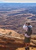
The next morning, we got up and struck camp - temps were anticipated to have dropped to the high 30s overnight, but things warmed up fast in the sun. Once everything was packed, we headed over to the trailhead and started our uphill climb towards PBar "Lake". The trail was easy going, though surprisingly dusty. To my eye, the lake much more resembles a pond...it's a shallow depression in a clearing amidst the pines with no obvious inlet or outlet - though today, it's completely dry. After a brief stop to get clippers out, we started the descent along the Grant Creek Trail.

Heading down the Grant Creek Trail, it was obvious that someone has done some maintenance. The locust and raspberries have moved in to take advantage of the full sun on the slopes - the trail is currently passable with some light contact, but as the season progresses, I suspect it will quickly get swallowed. Keep an eye out for poison ivy as you contour around a small drainage just below the switchbacks as you get close to the junction with the Grant Cabin Shortcut. When we passed over the drainage, there was a little bit of water flowing, with plenty of bees and butterflies enjoying the shallow pools.

When we hit the junction for the Grant Cabin shortcut, we decided to do the loop of the lollipop counterclockwise to break up our climb on exit - I was feeling the altitude on the small climb up to PBar Lake, and the idea of doing all the elevation from the Creek out was not pleasant. Lost track of the trail in one section on our way down, but was able to pick it up again in short order. Made it to the creek, where we were greeted by the neighborhood welcome committee (cows). We wandered upcanyon a bit to have a quick look at Grant Cabin - the surrounding area shows lots of evidence of bovine habitation (lots of fresh cow patties complete with loads of flies), and the area immediately adjacent to the cabin has evidence of inconsiderate human visitors by way of abandoned waterbottles and other trash 😒

After another quick break, we continued onward, along side the burbling Grant Creek. It wasn't long until we came to the post (missing the sign) marking the junction with the Paradise Trail. Knowing that things were going to get warm on the ascent, we both dipped our towels in the creek to help keep cool and started climbing. The initial climb out from Grant Creek wasn't terribly steep, but the footing was loose and the trail was eroded with off camber slope. As we continued climbing, we found our well established track deviating from the marked route in HAZ. A cross reference to another mapping database showed us on the Paradise Trail, though now that I'm home and have access to my computer and the USGS topos, I'm not sure where the other mapping database got its data because the USGS topo matches what's in HAZ. Ah well, either way, we made it to Paradise Park, where we sat for a break while being serenaded by a rather loud bird.

Knowing that we had a long drive home, we didn't lollygag for too long before joining back up with the Grant Creek Trail to close our loop and begin the seemingly long hot climb back out. The climb was definitely warm in the unshaded sections, and I was very glad for the cloud cover that rolled in, along with the breeze that would kick up now and again. Soon enough, we were back at PBar Lake and shortly after that, back at the truck. After cleaning up as best as we could, we headed homeward, catching sight of loads of elk in some of the meadows along 191 on the way. It was a nice escape for the holiday weekend - thanks for the invite, J!

Wildlife: On trail: butterflies, lizards, and various birds (oh, and we can't forget the bovine welcoming committee!). On the drive: deer, squirrel, chipmunk, bluejays, and elk.

Other people: None! Hooray!
wildflower observationwildflower observationwildflower observationwildflower observationwildflower observation
Wildflowers Observation Isolated
some of my photos were blurry and not worth posting...but even so, there were few things in bloom...probably spent more time chasing butterfly photos instead of flower photos this time around.

dry P Bar Lake Dry Dry
_____________________
Happier when hiking....I may not move fast (and I'm often distracted by wildflowers), but I'll get there eventually 😆
  1 archive
May 26 2025
avatar

 Routes 31
 Photos 4,724
 Triplogs 187

50 male
 Joined Mar 14 2016
 Gold Canyon, AZ
Pbar - Grant - Paradise Lolly, AZ 
Pbar - Grant - Paradise Lolly, AZ
 
Hiking avatar May 26 2025
00blackoutTriplogs 187
Hiking11.10 Miles 2,534 AEG
Hiking11.10 Miles
2,534 ft AEG
 no routes
1st trip
With the holiday weekend and warm temps in the valley, I opted for a last-minute trip up NE to the Blue Range, and S was happy to join me. We drove up Saturday evening, found an isolated spot to camp for the night off FR58 before getting up early Monday, heading over to the TH. I've been wanting to check out Paradise Park for a couple of years now, but the first time I attempted it, I ran into a locust jungle, so I was hoping my luck would be better this time. Easy hiking with a good trail to P Bar Lake. Got to P Bar Lake (still not sure why it's called a lake) and started the descent. The descent down was not nearly as bad as it was last time I attempted it (someone has done some maintenance), but there is still some overhang of locust and raspberry that will grab you from time to time. I did some light trimming on the bigger pieces, but without a good cleaning soon it will be overgrown again. We decided to hike the loop counterclockwise to break up some of the elevation gain and headed down the Grant Cabin shortcut. Lost the trail through a section near the top, but overall not difficult to follow. Made it down to Grant Creek, where we took a few minutes to check out the old Grant Cabin and rehydrate. FYI - the bovines have made the cabin area their new home as we ran into several there and tons of fresh patties. As we continued, the next section of Grant Creek was nice, with a good trail, shade, and a good amount of water in the creek. After a bit, we crossed the creek and started a small climb up the Paradise Trail, which was my least favorite section as it was eroded quite a bit initially, with loose footing. As we continued down the Paradise trail, we followed the track making its way up and to the left of 7576, however, the HAZ route has the trail out on the cliffside before getting to Paradise Park. We saved roughly a mile and a half by doing this route. We spent a good amount of time at Paradise Park eating lunch, listening to a very loud bird sing the same song over and over again for a good 30 minutes, before we connected with the Grant Creek Trail. By this time, it was warm, and with no shade, I was completely dreading the climb back up to the lake. The first half of the ascent was hot and slow, however, some clouds and wind came in and made it much more tolerable. Got back to the TH around 3 and started the long drive home. Saw tons of deer and elk and got serenaded by turkeys at the campsite. The Blue is always a favorite of mine, even though it's a long haul. The weather was a bit cold overnight, but warmed up to 70 degrees by the end of the day. Thanks S, for joining me out in the Blue.
 Named place
 Named place [ checklist ]
[ checklist ]  Grant Creek  P Bar Lake

dry P Bar Lake Dry Dry
Completely dry, not even muddy.
_____________________
Hiking is just walking where it’s okay to pee. :y:
 
Oct 07 2024
avatar

 Guides 37
 Routes 556
 Photos 10,872
 Triplogs 1,052

43 male
 Joined Jan 21 2013
 AZ
P-Bar Lake Trail #326Alpine, AZ
Alpine, AZ
Hiking avatar Oct 07 2024
FOTGTriplogs 1,052
Hiking9.94 Miles 2,142 AEG
Hiking9.94 Miles   6 Hrs   51 Mns   1.80 mph
2,142 ft AEG   1 Hour   19 Mns Break
 
Partners none no partners
I was looking for things and clearing trails. Specifically, the locust choked descent of Grant shortly after P-Bar Lake.

Cold start, thirty six degrees at the TH. We ended up starting at 6:30. I cleared trail for some of the descent on Grant, but in general we kept moving to take advantage of the cooler temps for exploring. Nevertheless, it still started to feel a little warm due to the lack of cloud cover and the more tedious off trail travel, so we headed back. I gave Dot several rests in the shade along the climb up Grant and during those times I worked on clearing the trail to a pretty high standard in the areas near where I was able to find shade for Dot to lay down in. A couple of horsemen praised my work and gave us some extra water, which was appreciated. They were the only people we saw all day. Some nice clouds eventually rolled in making for some perfect fall hiking conditions.
 Named place
 Named place [ checklist ]
[ checklist ]  P Bar Lake
foliage observationfoliage observationfoliage observationfoliage observationfoliage observation
Autumn Foliage Observation Light

water 1 out of 5water less than maxwater less than maxwater less than max P Bar Lake 1-25% full 1-25% full
closer to like 1-5 percent full, brown and muddy.
_____________________
  3 archives
Aug 24 2024
avatar

 Guides 37
 Routes 556
 Photos 10,872
 Triplogs 1,052

43 male
 Joined Jan 21 2013
 AZ
P-Bar Lake Trail #326Alpine, AZ
Alpine, AZ
Hiking avatar Aug 24 2024
FOTGTriplogs 1,052
Hiking12.03 Miles 2,453 AEG
Hiking12.03 Miles   5 Hrs   49 Mns   2.26 mph
2,453 ft AEG      30 Mns Break
 
Route Scout Route Recorded  on Route Scout | Pop | Map | Popup | MapDEX
A nice little lollipop loop from the P-Bar Lake Trailhead. I started just after six and did not see anyone all day. Although, the trailhead was packed with vehicles, as was the Blue Range in general due to the opening weekend of archery season for deer.

P-Bar Lake was in excellent condition and scenic. The forest here looks better every year.

A short but sweet stroll along Foot Creek Trail, which was also in great shape and particularly scenic in the early morning light.

The descent down Grant Creek Trail is pretty brushy, with a solid mile or so of some semi-annoying locust and raspberry, however, I have seen it worse and there was only two downed trees. There were also a few short reprieves along the way. Nothing except locust can seem to take hold through this section, I wonder if that will ever change?

The Grant Cabin shortcut trail needs some deadfall removed, but most of it amounted to easy step-overs. A little brush, but barely worth mentioning.

The cabin has not changed much since my last visit, but Grant Creek has nearly been swallowed by creek side vegetation and downed trees in this area. There was a light flow. The hiking along Grant Creek was a little primitive at first, as I made my way to the junction with the Paradise Trail, but it got "better."

I walked by the Paradise Trail twice some how. Its intersections seems to be getting more obscure with each year. The first half to three-quarters of the trail was also brushy and more overgrown than I have ever seen it. The last little stretch was nice however, which made up for it. I had to put the rain coat on for about 15 minutes, as I approached the intersection with the Grant Creek Trail.

It was good trail along the nicely recovering Paradise Park, which was particularly scenic from the recent rains. The good trail continued until we reached the locust ascent.

Great day out in the Blue, with lots of nostalgia. It’s been awhile since I have knocked out a semi rugged loop in these mountains.
 Named place
 Named place [ checklist ]
[ checklist ]  P Bar Lake

water 1 out of 5water less than maxwater less than maxwater less than max P Bar Lake 1-25% full 1-25% full
_____________________
  4 archives
Jun 15 2024
avatar

 Guides 12
 Routes 192
 Photos 863
 Triplogs 356

42 male
 Joined Nov 30 2015
 Phoenix, AZ
Upper Grant Creek Trail #65 - Blue RangeAlpine, AZ
Alpine, AZ
Hiking avatar Jun 15 2024
ShatteredArmTriplogs 356
Hiking14.70 Miles 2,887 AEG
Hiking14.70 Miles   6 Hrs   58 Mns   2.27 mph
2,887 ft AEG      30 Mns Break
 
no photosets
1st trip
After finishing the lower part of Foote Creek trail a few weeks ago, I decided it might be a good time to see if I can "finish" the trail. I was thinking an out-and-back from P-Bar Lake TH down to the Horse Ridge junction would be the goal, although I wasn't expecting trail conditions to be very good. P-Bar Lake trail is a walk in the park, and once on Foote Creek trail, the lack of maintenance quickly becomes apparent after the Grant Creek trail splits off. Still, it was pretty easy to follow into the upper Foote Creek drainage; deadfall was really the biggest issue.

Once into Foote Creek, the trail pretty much disappeared, and it was basically side-hilling while climbing over logs. Did this for maybe a mile and decided at that point that Foote Creek would be best left unfinished, at least until someone decides to rebuild the trail. Also, the canyon was a little smoky, although not enough that I could smell it. At one point I could see smoke billowing up ahead; I didn't realize until after the hike that the fire was actually in Foote Creek, apparently around the Horse Ridge junction. Glad I avoided stumbling into an active fire... Really hoping that area doesn't get charred too badly.

After I decided to turn around, I figured I may as well go check out the Upper Grant Creek trail, which I attempted from the top a couple years ago, but quickly lost the trail. Headed down Grant Creek trail, which seems to see regular maintenance at least to Paradise Park - locust are starting to encroach, but not enough to really slow you down. Then down the Grant Cabin Shortcut. A little upstream from the cabin, found a nice spot to take a short break, then proceeded up canyon.

For the most part, route finding in Upper Grant Creek was not too difficult, and the trail exists in most places. But the locust are getting really bad, and if it's not trimmed soon, getting through this canyon is going to be very difficult. I was barely moving at 1mph through there. It was also getting pretty warm, even at 9000 feet.

Eventually I got to Hannagan TH, where I would've loved my car to have been at that point in time, but I had to get back to P-Bar TH. I opted to take Clell Lee Trail, since it would be a little shorter, all downhill, and I hadn't seen it all the way down to 191. It's a pleasant little valley. The mile or so along 191 was OK; as far as highways are concerned it's not bad, I only saw four vehicles total in the 15 minutes or so it took.
_____________________
  2 archives
Oct 06 2023
avatar

 Triplogs 71

male
 Joined Jan 23 2025
 Seattle, WA
P-Bar Lake Trail #326Alpine, AZ
Alpine, AZ
Hiking avatar Oct 06 2023
dhelderTriplogs 71
Hiking0.95 Miles 320 AEG
Hiking0.95 Miles
320 ft AEG
 no routesno photosets
1st trip
Linked   none no linked trail guides
Partners none no partners
 
Jul 12 2023
avatar

 Guides 94
 Routes 840
 Photos 22,055
 Triplogs 1,993

52 male
 Joined Sep 18 2002
 Tempe, AZ
Foote Clell Loop, AZ 
Foote Clell Loop, AZ
 
Hiking avatar Jul 12 2023
chumleyTriplogs 1,993
Hiking7.08 Miles 737 AEG
Hiking7.08 Miles   2 Hrs   27 Mns   3.03 mph
737 ft AEG      7 Mns Break
 
1st trip
Partners none no partners
I abandoned my plans for a 15 mile loop starting at dawn to try and beat the storms and instead stayed in camp and spread everything out to dry in the early morning breeze. By the time I got going it was almost 10, and I estimated my plan would be about a 5 mile loop starting with the Foote Creek trail, hoping that I could find the Clell trail or just wander up the draw where the topo trace indicated it would be.

Foote was nice enough, well maintained and cleared for the most part, though it did push through one severely burned stretch that hasn't seen much recovery except some ferns and locust. No biggie though, as all the deadfall had been cut. One short section had also recently been hit by a microburst, downing a dozen or more old-growth ponderosa in a span of a couple hundred yards. Glad I wasn't there for that.

Just to keep you honest, P— drops 300 feet to the highway, where I had to hoof it for 3/4 mile along Hannagan Creek to get back up to the draw that Clell Springs is in. The short stretch of highway walk featured zero vehicles, which is always nice when walking on a federal highway, and allowed me to spy the original road cut. If you think the 191 is a windy road now, you should pay attention to what it used to look like!

Upon reaching the pretty draw, the weather took a turn, and before long I was dodging the flash-bangs I had so hoped to avoid. It wasn't raining, and it was a minute or two between lightning strikes, but thunder was inside of 4 seconds so I did not particularly enjoy the last mile or so as I pushed my pace up toward 4mph.

Spent the next couple hours on the patio at the lodge enjoying the weather from a better spot.
 Named place
 Named place [ checklist ]
[ checklist ]  Clell Spring

dry Clell Spring Dry Dry
No sign of surface water here

dry Spruce Tank Dry Dry
Most of this entire draw was dry. Only one day of monsoon rain so far.

water 1 out of 5water less than maxwater less than maxwater less than max Triple Tank 1-25% full 1-25% full
_____________________
I'm not sure what my spirit animal is, but I'm confident it has rabies.
 
Jun 25 2023
avatar

 Routes 31
 Photos 4,724
 Triplogs 187

50 male
 Joined Mar 14 2016
 Gold Canyon, AZ
P-Bar Lake Trail #326Alpine, AZ
Alpine, AZ
Hiking avatar Jun 25 2023
00blackoutTriplogs 187
Hiking8.00 Miles 1,250 AEG
Hiking8.00 Miles
1,250 ft AEG
 no routes
1st trip
Too many things to do Saturday morning and early afternoon, but I still wanted to get into nature and some cool air this weekend, so I decided on heading over to the Blue. Car camped at the Red Hill TH for the night before heading over to the P Bar Lake TH to hike early Sunday. Got woken up at around 3:45am from a slight movement of my truck, followed by the sound of some heavy steps right outside. It was pitch black, couldn't see anything but I'm assuming it was an Elk since the steps sounded pretty heavy. Laid back down and in the distance I heard some wolves howling (which is awesome to hear). Got up at 5:15 and it was freezing pumpkin cold; 45 degrees out and I left my windows cracked. :( Before heading over to the other TH, I decided to do a quick mile hike up to the wilderness boundary on the Red Hill trail.

Red Hill Trail - Trail was in pretty good shape up to the boundary, one small section of light overgrowth as you got closer to the ridgeline but nothing horrible. If some maintenance isn't done in the near future on the bottom section near the TH it is going to turn into a Black Bear Raspberry diner. Currently just off trail but starting to encroach. Made it back to my truck and headed over to the P Bar Lake TH.

P-Bar Lake - My original plan was to hike the P Bar Lake trail over to Grant Creek and take it down to Moonshine Park, but things changed. The P Bar lake trail is in great shape, very small minor deadfall especially after you finish the initial climb and get closer to the junction but nothing major.

Foote Creek - Once I got on the Foote Creek trail from the P Bar Lake junction here came the deadfall over and over again with some taking me on a detour through New Mexican locust jungles. A ton of them looking pretty recent. No overgrowth issues on this one, the Locust is just off the trail though so it could get overgrown pretty quick without any type of use. I thought about continuing on Foote Creek past P Bar Lake but the trail disappeared into overgrowth and deadfall shortly after, so I decided against it.

Grant Creek - Quick break at P Bar Lake (still not sure why they call this a lake) and started my decent down the Grant Creek Trail. Initial part of the trail is good, then starts getting a little cramped but not horrible. As the trail turns to the left and goes into the steep drainage part it gets really bad. I ran into a Locust jungle that I could not see through and with the descent just starting not knowing if the rest of the Grant Creek Trail was gonna be the same, there was no way I was gonna fight it, so I turned around and headed back to my truck. Pretty disappointed on this one as I have been wanting to get into the Moonshine Park area for awhile now.

KP Rim - Decided to drive over and hike the KP Rim trail. The trail was good for about a tenth of a mile. Once the climbing started it thickened up and then turned into a Fern and Locust jungle. Had a good size tree blocking about halfway up and the only way past it was to get on all fours and crawl underneath. I pushed through the jungle hoping that it would give me some awesome views on top of the rim but no dice, so my blood donation was all for not. This trail is currently inhabited by thousands of grass hoppers who get pretty pissed off that you are disturbing them so they jump right into you; eyes, face, doesn't matter, they are just trying to piss you off. :o

It was a little warm in the sun (77 degrees) but it felt awesome to be back out in the Blue again enjoying the trees and the tons of Elk and deer. Did not see single person the entire day! Can't wait to get back out there again.
wildflower observationwildflower observationwildflower observationwildflower observationwildflower observation
Wildflowers Observation Light

water 1 out of 5water less than maxwater less than maxwater less than max P Bar Lake 1-25% full 1-25% full
I would not even think about filtering from this 'lake'. Barely any water and tons of animal tracks and scat.
_____________________
Hiking is just walking where it’s okay to pee. :y:
 
Jul 25 2021
avatar

 Guides 37
 Routes 556
 Photos 10,872
 Triplogs 1,052

43 male
 Joined Jan 21 2013
 AZ
P-Bar Lake Trail #326Alpine, AZ
Alpine, AZ
Hiking avatar Jul 25 2021
FOTGTriplogs 1,052
Hiking2.80 Miles 405 AEG
Hiking2.80 Miles
405 ft AEG
 
Linked   linked  
Partners none no partners
The trail has been cleared recently and was in great shape. The area continues to show signs of recovery. The fog this morning added to the scenic forest views. We turned around at P-Bar “Lake” which was just a large mud puddle.
wildflower observationwildflower observationwildflower observationwildflower observationwildflower observation
Wildflowers Observation Light

water 1 out of 5water less than maxwater less than maxwater less than max P Bar Lake 1-25% full 1-25% full
Good for fido and stock, but I’d prob pass on drinking personally.
_____________________
 
Aug 18 2020
avatar

 Guides 2
 Routes 5
 Photos 89
 Triplogs 19

59 male
 Joined Jan 28 2008
 Phoenix, AZ
P-Bar Lake Trail #326Alpine, AZ
Alpine, AZ
Hiking avatar Aug 18 2020
HeliopsTriplogs 19
Hiking11.00 Miles 3,202 AEG
Hiking11.00 Miles   6 Hrs      1.83 mph
3,202 ft AEG
 
no photosets
1st trip
Did this as a backpack a couple years ago and wanted my wife to see the area. After getting her to commit to a long day hike, off we went. We had a beautiful day for the hike - sunny a little warm. My wife and I agreed afterwards that this is a "B" hike. From P-bar down to the split of 305 and 306, it is really overgrown but there are some nice vistas ...so wear pants or take some shears. From the split, we went straight to the cabin. The cabin is not all that fascinating, but worth doing. The hike along the creek was one of the nicer highlights. Overall a great backpack or long day hike if you are in the area.
_____________________
  2 archives
Jul 20 2018
avatar

 Guides 27
 Routes 669
 Photos 12,096
 Triplogs 856

56 male
 Joined Jul 05 2006
 Mesa, AZ
Moonshine Park - Blue RangeAlpine, AZ
Alpine, AZ
Hiking avatar Jul 20 2018
DarthStillerTriplogs 856
Hiking12.40 Miles 3,202 AEG
Hiking12.40 Miles   7 Hrs   1 Min   1.88 mph
3,202 ft AEG      26 Mns Break
 
1st trip
This being the last weekend before my family comes back from Europe, I planned a trip to the White Mountains. This was the first of three hikes. Wally and I left Mesa about 4:45am and arrived at the trailhead a little after 9am. There was a 50% chance of thunderstorms for that weekend, but when we arrived, the skies were clear.

The main comment I have is that the official HAZ route for this hike needs to be retired with that designation. JJ's route should be the official route. This hike is a solid 11 miles, and we turned it into more than that with some missed turnoffs, and a couple mistakes in navigation. We noticed that the official route was off about a mile in after the first trail junction for Grant Creek. We took the right trail, but we weren't on the track. I could tell that we were headed in the right direction eventually, so I thought maybe the trail was re-routed. As the Grant Creek Trail descended, the views started to get really nice.

Later on, Wally and I missed the junction for the Paradise Trail. I had actually seen the marker, but it was nailed to a tree instead of on a post, so I had thought it was just labeling the trail. A few minutes later I decided to check my GPS and saw that we were off route and had missed the turnoff. Right about htat time at 11am, we heard the first rolls of thunder.

Once we were on the Paradise Trail, I noticed again that we weren't on the track. We still were going in the right general direction, but we were pretty far off from the offical route. Looking later, I can see that JJ's route is a way more accurate one for the actual trails out there.

This became a factor for us soon enough because we saw the trail split in two. The one trail headed downhill, and looked like it headed closer to Moonshine Park than the other one, and was closer to the "official" route. This trail dead ended at a wash in a narrow gorge, next to a bog. It also lost us over 100' of elevation. We decided to head back up. Wally was ahead of me and missed the turnoff on our way down and kept going back the wrong way, similar to what he and Joe did back in February on Oracle Ridge. I didn't miss it and quickly realized that he had gone the wrong way because I should have been able to see him along the trail.

After I got to the point where you have to go off trail to get to Moonshine Park, I called Wally and could hear him calling back. I headed towards Moonshine Park on a faint trail that follows the creek until I saw Wally. I told him to make a sharp left at the creek crossing.

Eventually you do have to go off trail to get to Moonshine Park. I had a hard time figuring out where to go and thought we needed to go up another 100'+ to a stand of Ponderosas I could see. To get there we needed to go through some very steep, loose rock and heavy vegetation. Wally was not enthused, but didn't complain. About halfway there, I looked at my GPS again, looked downhill and to the left and saw Moonshine Park. Sorry, Wally. Going back down was marginally easier than going up. We had lunch at the park and headed back.

We missed the turnoff again to the Grant Cabin Shortcut Trail, which was actulaly good because we got to see the remains of the cabin. The hike back up Grant Creek Trail was a bit of a slog, mainly because of the extra energy expended on our side excursions. Towards the top of Grant Creek, a fighter jet flew over the trees, making some of the most hellacious noise I've ever heard. I saw a fighter jet once before at Picacho Peak, but this one was way louder. My reaction was to hit the deck as it was at its loudest and closest.

The last mile the thunder got a little louder and more often, but no close strikes. Got lucky to end the hike without getting rained on, unlike the previous weekend.
 Fauna
 Fauna [ checklist ]
[ checklist ]  Western Tanager
_____________________
 
Jul 03 2017
avatar

 Guides 107
 Routes 249
 Photos 2,067
 Triplogs 514

male
 Joined Nov 18 2005
 Phoenix, AZ
Foote Creek Trail #76Alpine, AZ
Alpine, AZ
Hiking avatar Jul 03 2017
nonotTriplogs 514
Hiking8.00 Miles 800 AEG
Hiking8.00 Miles
800 ft AEG
 no routesno photosets
1st trip
Partners none no partners
76 north to P-bar, then back on 24. 24 is not on HAZ yet so I'll have to find time to add it. In general, 76 and 326 have way too many downed trees. However, 24 is very nice, even though most of it is a dirt road, it winds through a meadow and doesn't suffer from much in terms of treefall to spoil it.
wildflower observationwildflower observationwildflower observationwildflower observationwildflower observation
Wildflowers Observation Light

water 1 out of 5water 2 out of 5water 3 out of 5water less than max Clell Spring Gallon per minute Gallon per minute
Stream was running slowly in area, didn't look for actual spring.

dry Spruce Tank Dry Dry
I couldn't find a tank per se here

water 1 out of 5water 2 out of 5water 3 out of 5water 4 out of 5 Triple Tank 76-100% full 76-100% full
Where you first cross the highway a stream was flowing nicely.
_____________________
http://hikearizona.com/garmin_maps.php

Hike Arizona it is full of sharp, pointy, ankle-twisting, HAZmaster crushing ROCKS!!
Hike Arizona it is full of sharp, pointy, shin-stabbing, skin-shredding plants!
Hike Arizona it is full of striking, biting, stabbing, venomous wildlife!
  1 archive
Jun 17 2017
avatar

 Guides 37
 Routes 556
 Photos 10,872
 Triplogs 1,052

43 male
 Joined Jan 21 2013
 AZ
P-Bar Lake Trail #326Alpine, AZ
Alpine, AZ
Hiking avatar Jun 17 2017
FOTGTriplogs 1,052
Hiking3.93 Miles 470 AEG
Hiking3.93 Miles
470 ft AEG
 
Linked   linked  
Partners none no partners
I started at P Bar to do some further exploring of Foot Creek Trail past P-Bar Lake and its intersection with the Grant Creek Trail. I did not go far down Foot Creek, but it seems to be the same story, destruction and deadfall.

water 1 out of 5water less than maxwater less than maxwater less than max P Bar Lake 1-25% full 1-25% full
A muddy pit, so muddy the dogs could not even reach the water.
_____________________
  3 archives
Sep 03 2016
avatar

 Guides 37
 Routes 556
 Photos 10,872
 Triplogs 1,052

43 male
 Joined Jan 21 2013
 AZ
Grant Creek Trail #75 - Blue RangeAlpine, AZ
Alpine, AZ
Backpack avatar Sep 03 2016
FOTGTriplogs 1,052
Backpack15.18 Miles 2,846 AEG
Backpack15.18 Miles2 Days         
2,846 ft AEG
 
1st trip
I made another pilgrimage to the Blue Range this holiday weekend, but with company for a change. I took Jackie and the pack down to the cabin site on Grant Creek for a day of fishing and checking Moonshine Park off the to do list. The fishing was great and Moonshine Park proved to be a worthy side trip.

We hiked in the recently cleared P-Bar Lake Trail to Foot Creek and then down Grant to the cabin site. After about 15 minutes at the site, Jackie said, "Blanco smells something," I said, "I know probably a squirrel." Then moments later a bear went shooting out of the creek bed up the steep slopes of the canyon. Jackie's main goal was to see a bear over the weekend and we checked that off the list after a mere 15 minutes at camp! Although, Jackie was a little confused about the cinnamon color, having only seen a couple black bears in PA and may have double checked google on the way home to make sure it was not a grizzly that we saw. The fishing was great and I may have caught one of the largest Apache Trout most will ever see, but did release in good health. Moonshine Park is in great shape and is a gem of a little spot out there, but the trail is in need of some work. Great over night temps a lazy start the next day, a detour to Paradise Park and trail on the way back. We did not see anyone on the trails the entire time.

water 1 out of 5water 2 out of 5water 3 out of 5water less than max Grant Creek Medium flow Medium flow

water 1 out of 5water less than maxwater less than maxwater less than max P Bar Lake 1-25% full 1-25% full
closer to 1-5% full...muddy
_____________________
  4 archives
Jul 22 2016
avatar

 Guides 1
 Photos 32
 Triplogs 5

49 male
 Joined Oct 18 2006
 Farmington, UT
Grant Creek Trail #75 - Blue RangeAlpine, AZ
Alpine, AZ
Hiking avatar Jul 22 2016
haggsterTriplogs 5
Hiking6.15 Miles 1,800 AEG
Hiking6.15 Miles   5 Hrs      1.23 mph
1,800 ft AEG
 no routes
1st trip
Partners none no partners
Great hike down into Grant Creek. I went in via trail #326 to P-Bar Lake, then down trail #75 and the #306 Grant Cabin Shortcut. The burned sections really opened the views down into the Blue. Once I got down to Grant Cabin, I only fished about a mile towards Moonshine Park before I had to head back.
 Fauna
 Fauna [ checklist ]
[ checklist ]  Apache Trout
_____________________
 
Jul 16 2016
avatar

 Guides 6
 Photos 346
 Triplogs 225

69 male
 Joined May 13 2002
 Tempe, AZ
Upper Grant Creek Trail #65 - Blue RangeAlpine, AZ
Alpine, AZ
Hiking avatar Jul 16 2016
hikeazTriplogs 225
Hiking4.00 Miles 1,600 AEG
Hiking4.00 Miles   2 Hrs   45 Mns   1.45 mph
1,600 ft AEG
 no routesno photosets
1st trip
Not having been on this 'trail' since before the Wallow burn I was overdue. Well..maybe it should be re-named the 'Boot-camp Trail'. Although ruggedly beautiful, it was a full-body workout climbing up, over and around all of the dead-fall - especially with an overnight backpack. The upside of this rough travel (keeping fisherman impact to a minimum) is that the fish are abundant.
We started down the Steeple Trail 73 toward Grant Creek, originally planning to form a loop using the 65 trail downstream to the 305 trail to return. But after the blistering average down Upper Grant 65(< 2mph) and expecting the same on the 305 we decided to head out the 306, 75 and 76 trails.
306 is well-constructed and mostly undamaged by fire - beautiful. Once on the 75 it was still undamaged at the lower end but the upper reaches were fire-damaged with some dead-fall - although by Trail(?) 65 standards it was clear-sailing. The 76 trail to the west is about 80% fire-damaged but there ARE areas where you can see remnants of its former glory. Workarounds for dead-fall are straightforward.
We were visited by a 20 minute hail-storm and deluge at the end of the hike, offering a welcome coolness to the air.

NOTES: Although labeled here on HAZ as Trail 74, on maps and signage Grant Creek Trail is labeled as 75 - Important as most maps of the Blue list just the trail number, not the name.

One in our group short-cutted down Trail 326 and reported that it was pretty clear sailing and a pretty hike.
wildflower observationwildflower observationwildflower observationwildflower observationwildflower observation
Wildflowers Observation Isolated
_____________________
"The censorship method ... is that of handing the job over to some frail and erring mortal man, and making him omnipotent on the assumption that his official status will make him infallible and omniscient."
George Bernard Shaw
  13 archives
Jul 17 2014
avatar

 Guides 37
 Routes 556
 Photos 10,872
 Triplogs 1,052

43 male
 Joined Jan 21 2013
 AZ
Primitive Blue Range East, AZ 
Primitive Blue Range East, AZ
 
Backpack avatar Jul 17 2014
FOTGTriplogs 1,052
Backpack40.76 Miles 11,153 AEG
Backpack40.76 Miles3 Days         
11,153 ft AEG
 
I made another semi ambitious trek into the Primitive Blue Range. More specifically, I made my first significant indents into the more remote eastern portions. I say "semi ambitious" because I took along Cup and had to scale back some of my ambitions. However, Cup ended up doing just fine, Blanco loved carrying her food and we only had to alter our day two plans slightly in her consideration.

Day 1: I stayed at the Foot Creek Trail head and decided to just make the quick 2-3 mile drive up 191 in the morning to the trail head for P-Bar Lake Trail. Foot Creek TH is further off road has basic restroom facilities and forest service does not mind. The P-Bar Lake Trail is literally just a pull-off on side of road, not conducive to car camping with dogs. Day one miles seemed to go by and pile up fast. Grant Creek Trail is a really solid trail with minimal areas of complete fire devastation. The Paradise Park area is certainly in recovery phase, but looking very promising, with some stubborn ponderosa still alive and healthy guarding the meadows edges and several young 3-5 feet pine starting over among a mixture of fast growing aspen. Grant Creek Trail is a tad bittersweet though, as one can't help but think that eventually 9000 feet will have to be reached again after hitting a trip low of about 5,100 feet above sea level on the first day. Made camp at the intersections of Lanphier and Largo Canyon, great spot, probably pushed cup a little hard, (16.5 miles)threatened several times to storm but no significant rain.

Day 2I wanted to go the Bear Mountain look out, but Cup was a little beat after a tough day one, so I decided to skip Bear Mountain and return to the Blue River via Telephone Ridge Trail and Sawmill Trail. Was nice to finally get some data for this area of Primitive Blue Range. It will come in handy when I make my next trek there, hopefully to finally include a little dual state action and a quick cross over into New Mexico. Something I think Blanco and I could have knocked out with about a 55 to 60 mile trip, oh and maybe another day. Day two camp superb, had Cup off trail very early in afternoon, read some, prepped camp, cooled off in creek.

Day 3: A pretty standard hike out, however, did make a slight detour back down to Grant Creek via Paradise Trail #74. I am just trying to accumulate as much info for this area as I can, and I had not did that trail yet. In terms of miles, small detour, however, certainly added some more AEG to hike that I probably did not need and Cup almost certainly did not want. But the trail proved to be great! A real slice of "paradise" in spots, a tad tough to pick up near creek, some dead fall and erosion have really taken their toll on this trail's once much deeper cuts along the steep hillside leading down into Grant Creek. For a good laugh see my GPS Track where I turned around to go get my nice 16 dollar map, then stopped just under two tenths of a mile to return to pack where I was now sure I put it. Nope not in pack went back for map again, found about 100-200 feet further up trail from when I turned around first time. I had set map down to move a log in trail, never picked back up, but certainly not to proud to turn around twice in an attempt to recoup a $16.95 map.

Final Notes: AEG is probably a tad inflated, however, hard to hide from AEG in Primitive Blue Range easy to rack up out there and while it may look high, it is probably not as off as some might think.

Had to do more road walking then what I generaly like, but spirits were brightened by seeing a random white van with no windows driving around remote back roads with a personalized plate reading AMBRLRT, my thoughts exactly! At least he comes about it honestly.

Product Review I brought out my new Big Agnes Fly Creek 2 Platinum. Two thumbs up, was initially worried about durability with dogs, however, had both in tent by second night, no issues. So light and compact, found myself stopping to make sure I packed tent! I was not able to field test it in a good storm, but nice results for steady lighter drizzles.
 Flora
 Flora [ checklist ]
[ checklist ]  Red Raspberry
_____________________
  2 archives
Apr 12 2012
avatar

 Routes 596
 Photos 9,604
 Triplogs 2,400

58 male
 Joined Jan 30 2011
 Chandler, AZ
Moonshine Park - Blue RangeAlpine, AZ
Alpine, AZ
Hiking avatar Apr 12 2012
JuanJaimeiiiTriplogs 2,400
Hiking11.30 Miles 2,743 AEG
Hiking11.30 Miles   4 Hrs   1 Min   2.81 mph
2,743 ft AEG
 
Hiked this one a week ago but the last part of it was in the dark. I also didn't have time last week to make it out to "Moonshine Park". I figured given the name of the hike and all I had better go back and complete the mission. I also wanted to see where I got off track last week on the return. From the Grant Cabin going North on the Grant Cabin Shortcut Trail I got off course a little. I figured it happened because it was dark and that today it wouldn't happen again. Well guess what, it did. Once back on track I decided to go the opposite direction (counter clockwise) in the area where I got off track and try and connect the dots. Ah ha! I figured out the problem. The trail isn't there anymore! There is a short section (maybe a tenth of a mile) that got washed out in a large rock slide. Well at least I know now. Either way you can't really get lost here because you are following a drainage up.

Also worth noting is that there isn't an actual trail for the last couple hundred yards to Moonshine Park. Scott Warren mentions this in his book as well. Once at the end of the trail just turn right and head for the base of the tall mountain in the distance. It is a big open meadow.

Almost all the snow had melted in the last week and I only saw one deer. No other wildlife this trip.
_____________________
 
average hiking speed 2 mph
1, 2  Next

WARNING! Hiking and outdoor related sports can be dangerous. Be responsible and prepare for the trip. Study the area you are entering and plan accordingly. Dress for the current and unexpected weather changes. Take plenty of water. Never go alone. Make an itinerary with your plan(s), route(s), destination(s) and expected return time. Give your itinerary to trusted family and/or friends.

helpcommentissue

end of page marker