username
X
password
register
for free!
help
ArticlesGuidesRoutes
 
Photosets
 
 Comments
triplogs   photosets   labels comments more
Cave Creek Indian Ruins at Chalk Canyon - 25 members in 53 triplogs have rated this an average 3.8 ( 1 to 5 best )
1, 2, 3  Next
53 triplogs
login for filter options
Aug 16 2025
avatar

 Guides 27
 Routes 670
 Photos 12,111
 Triplogs 857

56 male
 Joined Jul 05 2006
 Mesa, AZ
Cave Creek Indian Ruins at Chalk CanyonPhoenix, AZ
Phoenix, AZ
Hiking avatar Aug 16 2025
DarthStillerTriplogs 857
Hiking11.40 Miles 1,290 AEG
Hiking11.40 Miles   5 Hrs   26 Mns   2.12 mph
1,290 ft AEG      3 Mns Break
 
Linked   linked  
Partners partners
wallyfrack
Route Scout Route Recorded  on Route Scout | Pop | Map | Popup | MapDEX
I picked this area because it's just a little higher than metro Phoenix so it's a few degrees cooler, especially with an early start. I did this hike 7 or 8 years earlier, but in the opposite direction.

We actually skipped the ruins by Chalk Canyon. Once we got out of Chalk Canyon, we headed north on the Cave Creek Trail for another mile and then got off trail to check out the plane wreck. Before we even found the plane wreck, Wally spotted the remains of some ruins, which I knew were in this area as well. After checking out the plane wreck, we made our way down to Cave Creek where what's left of a ranch is there. There is a cairned route down there that eventually turns into a primitive road, of sorts. This entire area is full of ruins and sherds all over the place. We could have easily spent hours checking out a huge area here of ruins. It looks like another pueblo and is within eyeshot of the Skull Mesa ruins up above. There area also several flat areas on the way down the hill that have a look of human activity, certainly not natural looking to have a flat area on the hill.

Once the cairned route turns into the road, there a very large petroglyph on a flat rock. A mile south of the ranch were we got down to the creek, we checked out the petroglyphs that are just below the Cave Creek Ruins by Chalk Canyon.

On the way back Wally kicked out 3 deer by a dwindling water source and we spotted a bee swarm hanging out on a branch by the junction of trails 4 and 247. On they way out and again on the way back Wally started hiking up Trail 252, which would have taken him completely off course. Fortunately on the way back I spotted him taking the wrong trail.

It was warm here and there on the way back, but there were several breezes that kept it pleasant. Stayed under 100 the entire time, which is unheard of for August.
_____________________
 
Mar 22 2024
avatar

 Routes 7
 Photos 240
 Triplogs 19

male
 Joined Nov 24 2023
 Tempe, AZ
Cave Creek Indian Ruins at Chalk CanyonPhoenix, AZ
Phoenix, AZ
Hiking avatar Mar 22 2024
overthehillsfarawaTriplogs 19
Hiking10.40 Miles 1,083 AEG
Hiking10.40 Miles   2 Hrs   47 Mns   3.74 mph
1,083 ft AEG10 LBS Pack
 
1st trip
Linked   none no linked trail guides
Partners none no partners
Took the Metate trail in, missed the petroglyph panel somewhere near the beginning will need to go back sometime. Got one nice pic of a metate and kept moving. A bit tight for time so I jogged as much as I could. The trails are in great shape, not terribly rocky, easy to follow. The cacti out in that area are absolutely enormous, 40+ feet tall. The water level was low so the foot bridges weren't necessary but I still had fun with the various plank boards, a log, and stone stepping. I cleaned up the GPS to remove long turns, etc so my distance went over.
There was relatively little off-trail for this one. It was a warm day but the grass was quite low so I wasn't too nervous. Then I heard something in a nearby bush at one point and stopped, made some noise and stomped a bit and waited and listened... bang! I was hit around my Achilles! I jumped out my skin and watched a large cactus chunk fling forward from my leg. Never so happy to be stabbed by a cactus.
I arrived a little north of the ruins and found just a bunch of big rocks and was pretty disappointed. But making my way south a little found well worn foot paths and then the real ruins which were pretty sprawling. A couple rooms had better remaining walls and weren't totally overgrown. There was 1 sherd laid out on a rock. I didn't have enough time to explore as much as I wanted to. I think I read there are other petroglyphs up on top, south of the ruins? Maybe someone can confirm.
I deviated from the official triplog that hurtles directly down the hillside. The topos had shown a gentler slope to the north that I planned to follow west to the ravine for only a small added distance. I was extra delighted to quickly run into a path as I headed north. Not sure if it was meant for people or just made by the cattle but it was as good as any trail I had taken this far and headed exactly where I wanted to go. The cattle smell was prevalent, but I pretended it was just good cheese. I accidentally spooked 1 cow up ahead as I ran downhill. The path made it super easy to get down to the ravine.
I came back south until I was below the ruins and there were obvious well-worn footpaths on the east side cutting up to where the big petroglyphs are. The main panel is really big and impressive, probably 4-5 feet across. The large stick man is maybe 1.5 feet tall alone. Again I would have liked to poke around the surrounding area a bit longer to see if there were other glyphs but had no time. I missed the metates and sherds in the area as well.
On the way out I felt a good sudden stab in the ball of my foot but only once. 50 yards later I get stabbed again. Took my shoe off, took off the laces, took out the insole, clearly a sharp thorn pierced up through the bottom and was now a spike in the corner of my shoe. I had forgotten to bring tweezers and it was wedged in there pretty good, but managed to get it out with my fingers.
  1 archive
Mar 19 2022
avatar

 Guides 25
 Routes 376
 Photos 5,897
 Triplogs 346

40 male
 Joined Mar 01 2018
 Chandler, AZ
Chalk Canyon Ruins and Elephant Mountain, AZ 
Chalk Canyon Ruins and Elephant Mountain, AZ
 
Hiking avatar Mar 19 2022
John10sTriplogs 346
Hiking14.56 Miles 2,393 AEG
Hiking14.56 Miles   9 Hrs   52 Mns   2.06 mph
2,393 ft AEG   2 Hrs   48 Mns Break
1st trip
We'd had Chalk Canyon on our list for quite a while and decided to make that our main destination today. We started at Spur Cross Ranch Trailhead, and there was a lot more water in Cave Creek than expected...water levels were a lot lower in late December when we hiked to the Skull Mesa ruins, and I don't remember any significant rainfall since then. Regardless, it was nice to see.

It was mostly fast, pleasant miles on the hike to the ruins, with comfortable temperatures and a lot of wildflowers and birds. After we left Cave Creek Trail and approached the ruins site, we started to see increasing concentrations of pottery sherds and petroglyphs. One of the first petroglyphs we saw east of the ruins was a human figure with a zigzag pattern leading toward a spiral/circle of life engraved in the rock. Always fun to guess the meaning behind the drawings...

We spent some time exploring the ruins on the west edge of the mesa. We had the site to ourselves, and it offered a different perspective looking up at the ridge with the Skull Mesa ruins to the north. A lot of the walls were deteriorated at this site, but it was a large complex, and a few rooms had taller, more intact walls with some mortar still visible. One long, narrow room had a doorway made of white rocks that stood out from the darker ones that made up the other walls and virtually all the other structures, and it looked like rocks had been stacked loosely in modern times to block off the doorway for some reason.

After exploring the ruins, we dropped down off the west edge of the mesa toward the trail and Cave Creek below. It was a steep, loose descent in places, especially near the top, but we were able to avoid the brush almost entirely and saw more pottery and a few petroglyphs on the way down the slope. The area at the bottom was the highlight of the site, with an impressive concentration of petroglyphs and metates/rock slicks.

A set of three large boulders were covered in various petroglyphs on the tops and sides, and one vertical panel had one of the largest human figures I've seen, at 2+ feet tall. Others nearby had spirals and various symbols carved all over the flat tops. As we explored the area, we counted ~10 metates, several with grinding stones, and many more petroglyphs and pot sherds...a really nice area.

[ youtube video ]
[ youtube video ]

As we hiked back toward the trailhead, we took Metate Trail and checked out the namesake metates and the pool while dodging the crowds. Other than coming down the steep side of the mesa, it was quick, easy miles, and with a lot of afternoon remaining, we headed toward Elephant Mountain to see how far we could get with our remaining time. @TboneKathy waited below the saddle while I headed for the peak. I came up a little short, about a quarter mile from the summit, before I ran out of time and decided to turn around, but getting up as far as I did provided a nice vantage point to see the Elephant Mountain ruins on the ridge below, so it was a worthwhile effort even if I'll have to come back again to reach the peak.

[ youtube video ]

On the hike out, @TboneKathy nearly stepped on a Gila monster before seeing it at her feet...I don't usually think of those as blending in very well with their orange stripes, but she somehow missed it :). About a mile from the trailhead a helicopter was circling overhead, and we could see emergency vehicles with lights flashing in the parking lot. The helicopter landed over there and took off again and circled a few more times, and it continued repeating that cycle once we back and packing up at our vehicle. There were three fire trucks (one that said "Heavy Rescue" on the side) and two ambulances, and we weren't sure if it was an active rescue or a training exercise with the way the helicopter kept coming and going.

It was a fun hike, and the area below the ruins, especially, exceeded expectations. We had comfortable weather, great scenery, and the hike up to Elephant Mountain was a nice bonus that wasn't part of the original plan...and, fortunately, no Gila monsters were injured during the hike :).
wildflower observationwildflower observationwildflower observationwildflower observationwildflower observation
Wildflowers Observation Light


water 1 out of 5water 2 out of 5water less than maxwater less than max Chalk Canyon Light flow Light flow
water report recorded in the field on our app Route Scout


water 1 out of 5water 2 out of 5water 3 out of 5water 4 out of 5 Metate Pond 76-100% full 76-100% full
water report recorded in the field on our app Route Scout
 
Nov 28 2021
avatar

 Routes 386
 Photos 49
 Triplogs 792

43 female
 Joined Jun 23 2015
 Phoenix, AZ
Cave Creek Indian Ruins at Chalk CanyonPhoenix, AZ
Phoenix, AZ
Hiking avatar Nov 28 2021
emilystardustTriplogs 792
Hiking8.66 Miles 932 AEG
Hiking8.66 Miles   4 Hrs   53 Mns   2.28 mph
932 ft AEG   1 Hour   5 Mns Break
 
no photosets
1st trip
Linked   none no linked trail guides
Partners none no partners
Route Scout Route Recorded  on Route Scout | Pop | Map | Popup | MapDEX
_____________________
 
Nov 20 2021
avatar

 Routes 181
 Photos 901
 Triplogs 259

50 female
 Joined Mar 09 2010
 Chandler, AZ
Cave Creek Indian Ruins at Chalk CanyonPhoenix, AZ
Phoenix, AZ
Hiking avatar Nov 20 2021
azlaurieTriplogs 259
Hiking10.43 Miles 1,314 AEG
Hiking10.43 Miles   6 Hrs   1 Min   1.95 mph
1,314 ft AEG      40 Mns Break10 LBS Pack
 
1st trip
Linked   none no linked trail guides
Partners partners
dswitzer3
Route Scout Route Recorded  on Route Scout | Pop | Map | Popup | MapDEX
Don and I drove out to Spur Cross to hike this trail, find the Ruins, and see the Petroglyphs. Found the Petros, super cool. Saw 5 metates as well. On the find the Ruin. Knew about where it was, but getting to it from where we were at was a challenge. Choice was to scale a mountain that was pretty dang steep. So we opted to go around the mountain. Found a prob really old Ford truck upside down on way. Then total bush wackin and traveling sideways in knee high grass. Took quite a long time and effort. Seeing another trail across the canyon was destination. After getting to it we still had about 5 miles to go. Sad we didn't find the ruin but that's okay. Saw no one for about 7 miles. Me and my man, alone in the middle of no where, that's our jam. ♥
_____________________
♥ Timing is Everything ♥
  1 archive
Nov 16 2021
avatar

 Guides 8
 Routes 70
 Photos 3,208
 Triplogs 273

59 male
 Joined Oct 07 2017
 Chandler, AZ
Cave Creek Indian Ruins at Chalk CanyonPhoenix, AZ
Phoenix, AZ
Hiking avatar Nov 16 2021
YoderTriplogs 273
Hiking8.90 Miles 1,100 AEG
Hiking8.90 Miles   4 Hrs   1 Min   2.83 mph
1,100 ft AEG      52 Mns Break10 LBS Pack
 no routes
1st trip
Linked   none no linked trail guides
Partners none no partners
A nice hike, Trails were very easy to follow. Did have to wonder around to find the ruins, and the scramble down to the stream in the valley wasn't so fun, but well worth it. the Petroglyphs on the two big boulders were pretty great. Glad we did this hike not nearly as hard as I was expecting.
_____________________
J. Yoder
 
May 30 2020
avatar

 Guides 1
 Photos 355
 Triplogs 87

37 male
 Joined Jul 22 2003
 Scottsdale
Cave Creek Indian Ruins at Chalk CanyonPhoenix, AZ
Phoenix, AZ
Hiking avatar May 30 2020
fairweather8588Triplogs 87
Hiking8.30 Miles 1,657 AEG
Hiking8.30 Miles   3 Hrs   33 Mns   2.34 mph
1,657 ft AEG
 no routes
1st trip
Linked   none no linked trail guides
Partners none no partners
Straight out and back, didn’t make a loop out of it like the write up suggests. Started at the TH at 5:15 so we managed to keep in the shade for most of the hike. A few pottery sherds up top and some fairly over grown ruins, with the petroglyphs at the bottom of the hill right next to the trail being a pretty big highlight. Gnats were out in full force, if we happen to explore the ruins any further we’ll be sure to bring along some repellent
_____________________
No man should go through life without once experiencing healthy, even bored solitude in the wilderness, finding himself depending solely on himself and thereby learning his true and hidden strength

Kerouac
 
Apr 10 2020
avatar

 Guides 7
 Routes 72
 Photos 14,456
 Triplogs 627

62 female
 Joined Aug 19 2011
 Scottsdale, AZ
Cave Creek Indian Ruins at Chalk CanyonPhoenix, AZ
Phoenix, AZ
Hiking avatar Apr 10 2020
outdoor_loverTriplogs 627
Hiking10.00 Miles 1,200 AEG
Hiking10.00 Miles
1,200 ft AEG
 
1st trip
Partners partners
LosDosSloFolks
Greg wanted to go look for some Prime Real Estate and invited me to go with him. I was ready for a bit more mileage and I really enjoyed the last outing at Spur Cross, so I took him up on it. I even managed to convince him to start early, more to avoid people than anything else. Although it was a bit colder at the start than I thought it would be, it was a good call. The Parking Lot was full upon our return and we started running into more and more people (and horses) on the return, the closer we got to the TH.

Decided to take the road out and then Metate Trail back. Another good call, as the wildflowers along the road were pretty sweet. The water level in Cave Creek was even higher than when we were here 3 weeks ago, so finding decent crossings to keep the feet dry was just a tad more challenging than last time. Since it was pretty chilly with a breeze and the sun took it's time cresting over the mountains to the east, we pretty much kept moving for awhile and made good time to the Skull Mesa TH. Once we passed the Cottonwood Trail, I was in new territory. Even when the sun hit, it stayed chilly for a bit, but the uphill on Cave Creek Trail finally started to warm us up.

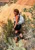
A few Photo Ops along the way, mostly for butterflies as there are more species out these days. They were enjoying the forests of blooming thistle which have gone nuts since last time I was out here. I can't remember seeing them so tall and robust as they are this year. Cool to look at, but a bitch to bushwack through. :lol: I was actually enjoying the uphill workout which is rare for me. I didn't stop frequently or for long until we hit the creek down in Chalk Canyon. Just before the bottom, coming down the hill, a hill bordering the Trail was seeping water from several spots and formed a small creek, which dumped into the larger creek at the bottom. Once we hit the bottom, the main creek was lightly flowing, so it was a great place to take a snack break, before heading back up out of the canyon. So we take a break and after a bit, Greg decides to get a head start up the hill. He isn't gone more than 90 seconds and I hear this weird noise that's getting immediately louder and I thought I was going to witness some sort of plane crash. I could not believe how loud it was and from where I was, I couldn't see the plane go over. But then, another, noise and I looked up again and saw the 2nd fighter jet streak by and bank to the left. Those suckers were LOW! :sweat: The noise was really deafening, even for someone with hearing loss. :o I haven't experienced a low fly-by like that, since my Dad and I were fishing on San Carlos Lake years ago. Except those 2 fighter jets were skimming the water and we didn't hear a sound until after they passed over our heads! We both about fell out of the boat! Pretty cool encounters!

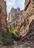
So we head up out of Chalk Canyon, top out and leave the Trail, heading for the Ruins. By the time we got halfway to the edge, the grasses and other flora were pretty much thigh high. Made for some slower going and interesting footing as you could no longer see the rocks and holes in the ground. And the rocks became a lot more numerous the closer we got. And I felt like the grass and foxtails got even higher. :sweat: But we got there and started looking at all the rooms and the artwork. Prior Civilizations had to have coined the term "room with a view" as their building site had amazing views of New River Mesa and Cave Creek. After Greg found the particular residence he was looking for, we started wandering back south along the edge, watching for more message boards. We decided to descend off the south end where it was a bit less steep, rather than take the steeper descent straight down into a bunch of really thick vegetation. It was a good call as I probably would have lost a lot more blood on the steeper route. :sweat: Thinking back on it now, if I ever do this again and Chalk Canyon is flowing, I might just go back out to the trail, take it back down to the bottom of Chalk and then just go down the Creek. Might be the easiest route of all and it looked like there was some cool stuff down there.

We get down to the bottom without breaking any bones and catch the trail to go back. Stopped at a creek crossing for a lunch break and start running into people, and people on horses. Lots of Horseback Riders out on this day. After the break, Greg takes off down the trail while I'm still packing up and I catch up to him a bit later. We stop at one more creek crossing and Greg decides to dabble his feet in the water for a bit. It was getting pretty warm out. He was interrupted by more horseback riders wanting to cross the creek, so we packed up for the last time and headed for the barn. Took the Metate Trail back and stopped at the Spring for a minute or so, since I hadn't seen it in like 6 or so years. Still a cool place. But people were multiplying faster than we could count, so we hit the trail again and didn't stop until the vehicles. That place was really really busy at 2:30 in the afternoon and people were still coming in.

Great Hike, this area never disappoints and neither does the company. It's been really nice to go with someone that knows this area so well too. Thanks for the Invite Greg! Good Times!

*Take Note* Some of the Foxtail is no longer practicing social distancing, so be warned. While it's not doing a full on assault of socks yet, it's lovin' the mesh on shoes and boots.
wildflower observationwildflower observationwildflower observationwildflower observationwildflower observation
Wildflowers Observation Moderate
Brittlebush is still going strong in areas and the Lupine is insane in some of these areas. Still some Owl Clover, most of the other common wildflowers are getting sparse. The blooming Thistle is pretty abundant and tall in places. The Prickly Pear will be putting on a good show very soon.

water 1 out of 5water 2 out of 5water 3 out of 5water less than max Cave Creek - SPRCA Medium flow Medium flow

water 1 out of 5water 2 out of 5water less than maxwater less than max Chalk Canyon Light flow Light flow

water 1 out of 5water 2 out of 5water less than maxwater less than max Cottonwood Creek Light flow Light flow

water 1 out of 5water 2 out of 5water 3 out of 5water 4 out of 5 Metate Pond 76-100% full 76-100% full
_____________________
Life is not a journey to the grave with the intention of arriving safely in a pretty & well preserved body, but rather to skid in broadside, totally worn out & proclaiming, "Wow What a Ride!"
 
Apr 10 2020
avatar

 Routes 70
 Photos 3,081
 Triplogs 601

70 male
 Joined Feb 10 2019
 Cave Creek, AZ
Cave Creek Indian Ruins at Chalk CanyonPhoenix, AZ
Phoenix, AZ
Hiking avatar Apr 10 2020
LosDosSloFolksTriplogs 601
Hiking10.30 Miles 1,288 AEG
Hiking10.30 Miles
1,288 ft AEG10 LBS Pack
 no routes
1st trip
Partners partners
outdoor_lover
This has been on my list and with warm weather closing in I figured I better do it now or it would have to wait until fall. Mrs. SloFolks passed on my invite so I asked @outdoor_lover to join me and she said yes! Pam takes a lot of pretty pictures and that slows her down to exactly my speed...perfect. Our double lasso loop is shown in the photoset.

We started at 6am from the Spur Cross parking lot and it was COLD. We froze our :pk: off for the first two miles. I live just south of Spur Cross and during the winter it is usually a few degrees warmer up there than at my home, cool air sinking and all. It was 51* when I left home and 37* and very windy 5 minutes later. Go figure. Once moving I was OK with the exception of my hands and ears. FYI...Black Diamond trekking gloves do not provide any warmth...at all.

The absolute highlight of the trek up occurred during our first rest stop at Shulte Spring at the far east end of Chalk Canyon. Two F-15 fighter jets (I believe that's what they were...it happened so fast) flew over our heads clearing the canyon walls by not very much. The second hit his after burner and we could see the orange glow out of the engine. He did a super fast bank turning the air around his wings and tails to turn into water vapor. The sound was deafening and the visual was jaw dropping. Within just a few seconds they were screaming over Skull Mesa at a very low level and gone. They were having some big time fun!

To keep the triplog a reasonable length I'll provide more info in the photo captions. The ruins were interesting and we found lots of petroglyphs on top of the mesa near the remains of the 30 room settlement. Pottery shards were prevalent and the views from the top were incredible.
wildflower observationwildflower observationwildflower observationwildflower observationwildflower observation
Wildflowers Observation Moderate
Lots and lots of New Mexico Thistle along with all the other usual suspects.

water 1 out of 5water 2 out of 5water 3 out of 5water less than max Cave Creek - SPRCA Medium flow Medium flow

water 1 out of 5water 2 out of 5water less than maxwater less than max Chalk Canyon Light flow Light flow

water 1 out of 5water less than maxwater less than maxwater less than max Chalk Spring Dripping Dripping

water 1 out of 5water 2 out of 5water less than maxwater less than max Cottonwood Creek Light flow Light flow

water 1 out of 5water 2 out of 5water 3 out of 5water 4 out of 5 Metate Pond 76-100% full 76-100% full

water 1 out of 5water 2 out of 5water 3 out of 5water 4 out of 5 Shulte Spring Gallon + per minute Gallon + per minute
_____________________
"If you wait, all that happens is you get older"
 
Feb 09 2020
avatar

 Guides 12
 Routes 192
 Photos 863
 Triplogs 356

42 male
 Joined Nov 30 2015
 Phoenix, AZ
Cave Creek Indian Ruins at Chalk CanyonPhoenix, AZ
Phoenix, AZ
Hiking avatar Feb 09 2020
ShatteredArmTriplogs 356
Hiking12.30 Miles 1,516 AEG
Hiking12.30 Miles   5 Hrs   7 Mns   3.45 mph
1,516 ft AEG   1 Hour   33 Mns Break
 no routes
1st trip
Linked   linked  
Partners none no partners
Headed up to Spur Cross with no real plan, other than to check out the old 6L Ranch, which I had never been to. All this time, I didn't realize there was an actual trail the whole way...but there was.

Ran into a guy who said he used to work the ranch 30odd years ago, near the entrance gate. He told us a little about the place. The collection of petroglyphs right after entering the ranch was amazing.

Continued to the ranch, and checked out what is left of the pens. Not much there structure-wise. We headed up the old trail towards Trail 4, and upon reaching the top, found a cairn, and thought it might be a reasonable place for ruins. Sure enough, on a knoll overlooking the ranch, there were some ruins. Cool.

Continued up to 4, then headed south. Found what looked like an old junction, and figured it could be the route down to the chalk canyon ruins. Headed down there, and found the massive complex of ruins. Amazing. From there, we bushwacked back down to Cave Creek, and then out.

Good day, and a cool spot I for some reason never bothered to check out.
_____________________
  1 archive
Jan 19 2020
avatar

 Guides 33
 Routes 286
 Photos 445
 Triplogs 251

35 male
 Joined Oct 23 2017
 Tempe
Cave Creek Indian Ruins at Chalk CanyonPhoenix, AZ
Phoenix, AZ
Hiking avatar Jan 19 2020
KingLeonidasTriplogs 251
Hiking9.90 Miles 1,510 AEG
Hiking9.90 Miles   4 Hrs   24 Mns   2.42 mph
1,510 ft AEG      19 Mns Break6 LBS Pack
 
no photosets
1st trip
Linked   none no linked trail guides
Partners none no partners
Route Scout Route Recorded  on Route Scout | Pop | Map | Popup | MapDEX
Hiked to the Cave Creek Indian Ruins at Chalk Canyon with my wife. This was a new spot for us, we were looking for a hike that wasn't too popular (crowded), was reasonably physically challenging, and had some point of interest. With it's rarely explored ruins, this fit the bill nicely!

Trailhead/Getting there
The trip started at the spur cross ranch conservation area parking lot. There were quite a few cars in the lot but we did not have to wait to get a spot. After paying the entry fee ($3 per person) we started on the trail.

Trail Conditions
Despite the crowded parking lot the hiking population quickly thinned out after the first mile or so. It seems that most of the trails in this area run east towards the Elephant Mountain area and our northern path quickly cleared out.

The trail sees frequent equestrian traffic, we passed three separate groups on mules while we were there and there was a fair amount of dung that had to be stepped around.

There were 10 creek crossings that had to be traversed on this hike. Technically there are only 6 unique crossings but the route is a lasso-loop so you have to cross 4 of them twice. The crossings tended to be wide, shallow (ankle to calf deep), and not moving fast, at least while we were there. There were rock hopping opportunities at each of the crossings and we managed all of them without getting wet.

The condition of the trail varied. The earlier sections were mostly packed dirt but things got pretty rocky a mile or so in. From mile 5.2 to 5.9 (on the gps route uploaded from this trip) there is no trail to speak of. We actually missed the turn initially and had to turn back after going 1/4 of a mile farther north along the trail than we intended. After backtracking to a cairn, it is bushwhacking the rest of the way to the ruins. Leaving the ruins and heading back to the creek involved descending the cliff which was challenging and slippery scrambling for about 200' down. We had to contend with lots of loose rocks so the conditions probably change with each rainy season. The best way down one year may not be so good the next. We found and active hive of bees halfway down and gave them a wide berth. That cliffside is far from an optimal place to have to run from angry bees!

There was a second maintained trail at the base of the cliff and the conditions were more consistent on the return albeit with another two creek crossings.

Navigation
Navigation was straightforward for most of the trail. When crossing the creek we sometimes had to go a bit upstream or downstream to find a better rock hopping point but had little difficulty locating the trail on the opposite side. There was one point (around mile 2.3 if memory serves) where there is a "false" creek crossing. It looks as though you you have to cross to the east side of the creek but in reality you just traverse up the rocks on the western bank. The normal dirt trail becomes visible and continues around the bend.

In middle section of the lasso (where we missed the cairn and had to turn back) there is absolutely no trail to speak of. I consider myself a pretty good pathfinder (I can easily see and follow paths others do not notice) but this one was completely beyond me. The entire stretch from the maintained trail to the ruins was effectively a trackless grassy plateau. There was maybe 30' (in scattered sections) that might have been a hint of a game trail but it was nowhere near enough to navigate by. Getting through this section requires either a GPS (we used Route Scout) or a map and compass. According to the map there was supposed to be some sort of creek bed to follow but aside from some generally spongy ground (more dry and cracked/soft than spongy) we didn't find this to be the case. After attempting in vain to find a trail following the exact GPS route of the guide author, we eventually gave up trying to be precise and headed due west until we reached the cliff and headed north from there. With the right tools the ruins were not hard to find.

Getting from the ruins to the return trail of the lasso loop was less challenging from the navigational perspective. From the cliff side ruins you can see the maintained trail that runs parallel to the cliff easily. Simply go down the cliff and intersecting the maintained trail at its base is inevitable. There was no set trail down the cliff.

General Comments and Musings
The ruins were interesting and I assume "typical" for the region. They were similar in construction and condition to Circlestone Ruins. There appeared to be multiple smaller rectangular dwellings arranged over a fairly small area. There were also a few special gems. A particular stone near the center of the village was apparently used for milling. There was a concave section in the middle that had looked to have been carved out (It may have started out as a Metate) and two hand sized millstones (smoothed and with a grip for the purpose) were sitting on the rock. There was a selection of pottery shards, presumably collected by previous visitors, assembled in the concave section. This was really cool and also indicated exactly how infrequently these ruins are visited (if they were popular the pottery shards and millstones would probably disappeared long ago). There was also a rock on the far side (north) of the village with a few pottery shards on it but I was unable to distinguish a particular purpose for this stone (besides a convenient pottery collection point for an amateur archaeologist)

There were a few spots on the return loop that we did not fully explore. There was a spot on the map that was marked as a mining claim by the creek that was presumably used for prospecting. There was also a side trail further on that was not marked on the map that was faint and looked to be marked with a Petroglyph. We didn't explore this side trail and didn't see much of the Petroglyphs that are reported to be in this area so we might have to make a return visit and hike the route in the reverse direction.

This was a really cool area with a lot of trails and history. We will have to come back soon.

A video of the hike can be found here: [ youtube video ]

water 1 out of 5water 2 out of 5water 3 out of 5water less than max Chalk Canyon Medium flow Medium flow
Water was running and clear. We could rock hop across without getting our feet wet.

water 1 out of 5water less than maxwater less than maxwater less than max Metate Pond 1-25% full 1-25% full
full of algae and flowing slowly

water 1 out of 5water 2 out of 5water less than maxwater less than max Shulte Spring Quart per minute Quart per minute
Didn't venture to the source but the were stagnant pools where the trail crossed the spring. flow was visible but slow
_____________________
  1 archive
Dec 16 2019
avatar

 Routes 25
 Photos 19
 Triplogs 36

male
 Joined Jan 27 2014
 
Chalk Canyon Double Lolipop Loop, AZ 
Chalk Canyon Double Lolipop Loop, AZ
 
Hiking avatar Dec 16 2019
norm5715Triplogs 36
Hiking9.76 Miles 956 AEG
Hiking9.76 Miles   5 Hrs   43 Mns   1.99 mph
956 ft AEG      49 Mns Break
 
no photosets
1st trip
Partners none no partners
It’s an easy hike to the river either down the road near the trail head or the Metate trail. The river easy to cross and we did have to cross about five times.

Shortly after the final crossing, there’s a sign to the Skull Mesa trail. At that point we turned left and went about 200 yards. We then made a sharp right turn. The trail is difficult to see, but there is a cairn. The trail is rocky but easily navigated.

Following the GPS route to N33° 55.917' W111° 56.570'. Then turn left (west) to the edge of a cliff. You will see the Indian ruins and several amazing petroglyphs.

At that point our group had lunch and took in the amazing views. We spent great deal of time looking over the site.
Returning to the trail, we went north about 1/10 of a mile before descending the cliff. I would not recommend descending immediately west of the ruins. It’s very steep. The descent we took was difficult and slow, but not quite as tricky.
Returning along the lower trail we were able to see several more petroglyphs.

Lastly, after crossing the river several times, you will come to the Metate trail. I recommend taking the Metate trail back. The trail is very easy, but beautiful.

All in all, a wonderful day with blue skies and temps of about 65 degrees. A perfect day for a hike.
_____________________
 
Mar 31 2019
avatar

 Routes 215
 Photos 1,337
 Triplogs 124

53 male
 Joined May 26 2017
 Phoenix, AZ
Cave Creek Indian Ruins at Chalk CanyonPhoenix, AZ
Phoenix, AZ
Hiking avatar Mar 31 2019
Nate_FTriplogs 124
Hiking7.44 Miles 885 AEG
Hiking7.44 Miles   3 Hrs   41 Mns   2.18 mph
885 ft AEG      16 Mns Break
 
Linked   none no linked trail guides
Partners partners
caragruey
Quick hike in Cave Creek on a beautiful Sunday. Been to these ruins before, so I spent more time below just checking out more glyphs and found a couple more metates too. The creeks were flowing good and the trail was way overgrown, knee high almost. Of course, crossing the creek meant getting the feet wet. :sweat:
Good selection of wildflowers today! :)
 Flora
 Flora [ checklist ]
[ checklist ]  Stinknet
wildflower observationwildflower observationwildflower observationwildflower observationwildflower observation
Wildflowers Observation Moderate

water 1 out of 5water 2 out of 5water 3 out of 5water less than max Chalk Canyon Medium flow Medium flow

water 1 out of 5water 2 out of 5water less than maxwater less than max Cottonwood Creek Light flow Light flow
_____________________
 
Mar 31 2019
avatar

 Guides 4
 Routes 52
 Photos 1,303
 Triplogs 75

female
 Joined Feb 04 2017
 Sun City
Cave Creek Indian Ruins at Chalk CanyonPhoenix, AZ
Phoenix, AZ
Hiking avatar Mar 31 2019
caragrueyTriplogs 75
Hiking9.50 Miles 1,657 AEG
Hiking9.50 Miles
1,657 ft AEG
 
1st trip
Linked   none no linked trail guides
Partners partners
Nate_F
Nice little stretch on a lovely Sunday morning. At the first water crossing we noticed the boards were missing so feet wet time! There were heaps of butterflies dancing around all the beautiful flowers as we strolled through the thick overgrowth along the trail. Headed to the lower petroglyphs area and back out. Made for a nice small hike.
 Culture
 Culture [ checklist ]
[ checklist ]  HAZ Gear
wildflower observationwildflower observationwildflower observationwildflower observationwildflower observation
Wildflowers Observation Substantial
_____________________
 
Jan 25 2019
avatar

 Routes 61
 Photos 1,008
 Triplogs 224

44 male
 Joined Aug 19 2009
 The Basin
Cave Creek Indian Ruins at Chalk CanyonPhoenix, AZ
Phoenix, AZ
Hiking avatar Jan 25 2019
survivordudeTriplogs 224
Hiking16.00 Miles 1,657 AEG
Hiking16.00 Miles   5 Hrs   57 Mns   3.05 mph
1,657 ft AEG      42 Mns Break
 
Another Luna hike in the books. Paid my $3 and passed several large groups on my way to the Tonto line. Anytime I come up here, I go through the Metate trail because why not? It is fantastic. Normal water flow in the creek. Stopped at the glyph area. The aliens are still there.. because we never left. Kept going up creek past the old truck and into a small corral area. We had a small snack and hung put by the creek for a while. When we were leaving I found a trail leading up the hill, so I decided to keep going up it and the path was pretty easy to follow up to where it started to flatten out a bit and I lost the trail until I saw some pink ribbons and I followed those for a while until I lost those also. As I was checking the map and reorienting myself, I came upon a nice ruin area with several walls and some great views. Eventually, I found the Cave Creek trail and took that back to Spur Cross. Luna is loving jumping in all these pools and puddles lately, she is really coming around.
_____________________
“There is nothing that exists outside the thought of the immediate moment.”
 
Jan 19 2019
avatar

 Routes 215
 Photos 1,337
 Triplogs 124

53 male
 Joined May 26 2017
 Phoenix, AZ
Cave Creek Indian Ruins at Chalk CanyonPhoenix, AZ
Phoenix, AZ
Hiking avatar Jan 19 2019
Nate_FTriplogs 124
Hiking8.86 Miles 1,204 AEG
Hiking8.86 Miles   5 Hrs   1 Min   1.90 mph
1,204 ft AEG      21 Mns Break
 
Linked   none no linked trail guides
Partners none no partners
3H - Group
Great little hike in the Spur Cross area to check out some Native American ruins.
Beautiful day in the Cave Creek area; there's a lot more to explore out here, someday...
It's really nice out here!
Iv'e checked this one off the list, I'll come back one day and do the complete Skull Mesa route.
It's great that I live close to the park. I will be back!

water 1 out of 5water 2 out of 5water less than maxwater less than max Cave Creek - SPRCA Light flow Light flow

water 1 out of 5water 2 out of 5water less than maxwater less than max Cottonwood Creek Light flow Light flow
_____________________
  1 archive
Jan 12 2019
avatar

 Guides 99
 Routes 1,485
 Photos 16,072
 Triplogs 1,375

male
 Joined Jan 07 2017
 Fountain Hills,
Skull Mesa and Chalk Canyon, AZ 
Skull Mesa and Chalk Canyon, AZ
 
Hiking avatar Jan 12 2019
DixieFlyerTriplogs 1,375
Hiking15.10 Miles 3,075 AEG
Hiking15.10 Miles   8 Hrs   40 Mns   2.56 mph
3,075 ft AEG   2 Hrs   46 Mns Break
 
I took a few people on this hike that I had done a few weeks ago.

We made a loop out of the hike, starting and ending at the Spur Cross TH. We started out on the Spur Cross Trail, and about the time we got to the Tonto National Forest we made a short off-trail jaunt to hit Trail 247A, and then made our way up to Skull Mesa. After traversing the mesa to get to the fort ruins on the NW side of the mesa, we descended from the ruins down the east side of the mesa, and angled our way north and then west until we got to Cave Creek Trail #4. On the way back we stopped off at the Rim of Chalk Canyon to see some pueblo ruins, and then dropped down into the Canyon to check out some petroglyphs and metates.

Compared to the "standard" out-and-back route to the ruins, I'd estimate that this route was 2.5 miles shorter and had 800'-900' less elevation gain.

I found 3 geocache containers on the mesa.
_____________________
Civilization is a nice place to visit but I wouldn't want to live there
 
Dec 25 2018
avatar

 Routes 36
 Photos 2,658
 Triplogs 1,347

67 male
 Joined Jul 28 2004
 Scottsdale, AZ
Cave Creek Indian Ruins at Chalk CanyonPhoenix, AZ
Phoenix, AZ
Hiking avatar Dec 25 2018
mazatzalTriplogs 1,347
Hiking9.50 Miles 1,140 AEG
Hiking9.50 Miles
1,140 ft AEG
 no routes
1st trip
Partners none no partners
Went out to just beyond 6L ranch and came back along Cave creek. Got a few sprinkles but not much.
Not many people except in SCRA.
Lots of flowers and fall color. Great day!
foliage observationfoliage observationfoliage observationfoliage observationfoliage observation
Autumn Foliage Observation Moderate
wildflower observationwildflower observationwildflower observationwildflower observationwildflower observation
Wildflowers Observation Moderate

water 1 out of 5water 2 out of 5water less than maxwater less than max Cave Creek - SPRCA Light flow Light flow

water 1 out of 5water 2 out of 5water 3 out of 5water 4 out of 5 Metate Pond 76-100% full 76-100% full
_____________________
  1 archive
Dec 05 2018
avatar

 Guides 99
 Routes 1,485
 Photos 16,072
 Triplogs 1,375

male
 Joined Jan 07 2017
 Fountain Hills,
Skull Mesa and Chalk Canyon, AZ 
Skull Mesa and Chalk Canyon, AZ
 
Hiking avatar Dec 05 2018
DixieFlyerTriplogs 1,375
Hiking18.10 Miles 3,500 AEG
Hiking18.10 Miles   10 Hrs   15 Mns   2.41 mph
3,500 ft AEG   2 Hrs   44 Mns Break
 
I had been to Skull Mesa and Chalk Canyon 3 times each but I had never done both on the same hike. So I talked Tracie into going on this hike with me in order to rectify that situation.

We started at the Spur Cross TH, and took the Spur Cross Trail into the Tonto National Forest. Once there, we went off trail for a bit to get on a use trail that connects with Cottonwood Trail #247 about a mile west from where the Cottonwood Trail meets Skull Mesa Trail #248. I had noticed that lindaagm came back this way from Skull Mesa, and I used her route to get over to this trail. I like this way much better than continuing on the Spur Cross Trail until it hits Cave Creek Trail #4, and from there taking the Cottonwood Trail all the way over to Skull Mesa Trail #248. The use trail was easy to follow, and I thought that it was a better trail than Cave Creek Trail #4, which I took on the way back.

Once we got to Skull Mesa Tail #248 we took it up to the mesa. It was a bit steep, but there are lots of switchbacks on the steeper sections, so the ascent wasn't bad at all. Once we got to the overlook, I looked to the east and could see some places that were obviously at a higher elevation than where we were at the overlook on the SW side of the mesa. My GPS measured the overlook at 4,260'. So we went about 1.25 miles to what I think is the high point of the mesa on the SE side of the mesa. My GPS measured 4,570', whereas the high point is supposed to be 4,595'. The altimeter in my GPS isn't 100% precise, and since I did not see any other points higher than where we were, I am going to declare victory on being at the high point of Skull Mesa.

We then went from the SE part of the mesa over to the NW corner of the mesa to the Indian Ruins. The traverse wasn't bad, although I did manage to get some prickly pear spines in the side of my shoes a couple of times. Along the way we came across some metates on the mesa (N33.93712° W111.92183°).

The fort ruins are impressive imho and are well worth the trip to see them.

On the way back, rather than going all the way back across the mesa, we dropped down to the east of the fort ruins. The slope there looked forgiving, and it turned out do be decent descent. We angled down first to the north and then to the west -- we hit Cave Creek Trail #4 in about 0.6 miles. The only problem is that after angling down the hill, my left leg is now shorter than my right one!

We took Cave Creek Trail #4 until we turned off to go the rim of Chalk Canyon and check out the petroglyphs and pueblo ruins there. Then we descended down into Chalk Canyon and saw a few more petroglyphs and metates. Then we continued south on the trail that took us to the Skull Mesa TH, and then went back to the Spur Cross TH. Once we got back into the Spur Cross Preserve, we took the Metate Trail back to the TH -- I much prefer the Metate Trail to the Spur Cross Trail.
wildflower observationwildflower observationwildflower observationwildflower observationwildflower observation
Wildflowers Observation Light
There were a few wildflowers blooming: brittle bush; turpentine bush; and globemallow, among others
_____________________
Civilization is a nice place to visit but I wouldn't want to live there
 
Oct 28 2018
avatar

 Routes 12
 Photos 51
 Triplogs 13

37 female
 Joined Jul 11 2018
 Phoenix, AZ
Cave Creek Indian Ruins at Chalk CanyonPhoenix, AZ
Phoenix, AZ
Hiking avatar Oct 28 2018
MandaBearPigTriplogs 13
Hiking9.09 Miles 1,080 AEG
Hiking9.09 Miles   4 Hrs   28 Mns   2.16 mph
1,080 ft AEG      15 Mns Break
 
1st trip
Linked   none no linked trail guides
Partners none no partners
I was set to delete this route and post nothing but I always say you learn from your mistakes, so I figured I should practice what I preach. Warning: do not follow my route trace unless you want an unnecessarily anxiety-ridden experience.

I want to note that I'm not a novice hiker, though I am an out of practice one. I grew up in rural southeastern Arizona and spent my early twenties in Tucson. Outdoor activities have been a part of my life from birth. The last 6 years I lived on the Southeast Coast where "hiking" is limited to beaches and swampy boardwalks. Needless to say, my route finding & bushwaking skills have declined.

Set out early this morning with the intention of exploring the ruins at Chalk Canyon following the official route trace. I had selected this hike earlier in the week, imported to Route Scout, and moved on with the humdrum of weekday life. Therein lies my biggest mistake - failing to review/print the route description before heading out or, you know, bringing along a dang map and compass.

Trail conditions were excellent if a bit muddy in spots. It was cool, slightly breezy, and the creek was running well given all the rain we've had this monsoon season. Unable to avoid wet feet at several crossings. The trail was washed out in a couple places but cairns and Route Scout got me through. Scared up a pair of mule deer near the border with Tonto NF, otherwise didn't see a single soul.

Upon arriving at the Skull Canyon trail head, I made my second mistake. Rather than heading up the trail counter-clockwise, I decided to take the clockwise route (FR 48) as it looked to be a gentler ascent. If I had reviewed the route description, rather than relying on a GPS trace, I would have know this was a mistake. Rather than following the established trail up to the mesa, my choice took me along the creek, following the base of the mesa. This is important later.

I only realized my mistake when I came upon the petroglyphs. They jump out at you after rounding a bend, an absolutely spectacular grouping. After exploring the area a bit and finding several more glyphs which aren't visible from the trail, I had a sudden realization. I remembered the route guide recommending a steep hike down from the ruins to this boulder field. That meant I would have to ascend the steep cliff up to the ruins. I scouted around a bit but could make out no clear path up. At this point, my intuition was screaming at me to call it a wash and head back towards the car. I made the decision to ignore my feelings and try to pick my way up the cliff.

Dumb decision. I consider myself a pretty level-headed gal, but there were several moments during the climb that I was wracked with anxiety and sure I was going to tumble to my death. Lots of loose rocks and things were much steeper than they appeared from below. As I stated above, my route finding skills have seriously declined. The only thing that kept me going - I felt sure that once I topped out onto the mesa I would be able to easily see a trail. This assumption was based solely on the way the route trace appeared in Route Scout. If I had reviewed the route guide prior to heading out, or brought a map, I would have seen that the pueblo ruins are about 100 yards west of the trail.

I popped up onto the mesa literally into the pueblo ruins. Unfortunately at this point I was so shaken that I didn't take any time to explore or take photos. I was concerned about my phone battery dying and fixated on finding my way back onto the GPS trace as, you know, I did not bring a map and had no idea how to find the trail. After wandering atop the mesa for quite awhile and struggling to find my way to any semblance of a path towards the trace, I made the decision to simply head back down the cliffs the way I came up. What followed was essentially a controlled slide on my rear back down to FR 48. I encountered quite a few hikers and equestrians on my return.

While I was never truly lost, as I knew generally where I was and how to get back to a trail by heading down towards the creek, I did engage in some seriously dangerous behaviors due to a lack of planning and judgement. I consider myself lucky to have gotten up and down that mesa with only a few scrapes and prickly pear pokes.

I want to be clear that Route Scout worked beautifully. This looks to be a semi-regularly traveled route based on the tracks I encountered, and there are no issues with the GPS trace itself. The issues I encountered today were all of my own making. At the end of the day I did get to see some amazing petroglyphs and had a lovely morning of secluded hiking (minus my terrifying rock climb). I'm going to let this serve as a lesson on being prepared, over-estimating my abilities, and over-relying on GPS technology to keep me safe and on-track. I will definitely be returning to complete this loop, prepared and humbled, in the future.
 
average hiking speed 2.25 mph
1, 2, 3  Next

WARNING! Hiking and outdoor related sports can be dangerous. Be responsible and prepare for the trip. Study the area you are entering and plan accordingly. Dress for the current and unexpected weather changes. Take plenty of water. Never go alone. Make an itinerary with your plan(s), route(s), destination(s) and expected return time. Give your itinerary to trusted family and/or friends.

helpcommentissue

end of page marker