username
X
password
register
for free!
help
ArticlesGuidesRoutes
 
Photosets
 
 Comments
triplogs   photosets   labels comments more
Phone Trail - 4 members in 11 triplogs have rated this an average 2.8 ( 1 to 5 best )
11 triplogs
login for filter options
Sep 15 2022
avatar

 Guides 1
 Routes 148
 Photos 9,925
 Triplogs 3,653

63 male
 Joined Apr 02 2005
 Mesa, AZ
Easy Breezy TrailSedona, AZ
Sedona, AZ
Hiking avatar Sep 15 2022
Tortoise_HikerTriplogs 3,653
Hiking5.98 Miles 504 AEG
Hiking5.98 Miles   2 Hrs   27 Mns   2.44 mph
504 ft AEG
 
1st trip
Partners none no partners
Route Scout Route Recorded  on Route Scout | Pop | Map | Popup | MapDEX
I started this hike from Courthouse Vista trailheads. I used Phone trail-Bell Rock trail-Templeton trail to get to Easy Breezy trail. About.6 of a mile. I followed the Eagles route from there, albeit backwards. You can start at the other end by using the Cathedral Rock trailhead. Use part of Cathedral Rock trail and Templeton trail to get to that end of Easy Breezy trail. Probably about.6 of a mile to get to that end too.
Evidence of recent rain but the red dirt packs nicely. Stayed mud free. Nice tree cover, views and plenty of interesting rock areas.
Only saw 5 mountain bikers and 1 hiker on trail.
Nice weather this morning and a very enjoyable outing!
_____________________
Tortoise Hiking. Stop and smell the Petrichor.
 
Oct 20 2021
avatar

 Routes 189
 Photos 7,244
 Triplogs 1,742

57 male
 Joined Apr 25 2011
 Goodyear, AZ
Slim Shady TrailSedona, AZ
Sedona, AZ
Mtn Biking avatar Oct 20 2021
NightstalkerTriplogs 1,742
Mtn Biking8.30 Miles 861 AEG
Mtn Biking8.30 Miles   2 Hrs   36 Mns   6.00 mph
861 ft AEG   1 Hour   13 Mns Break8 LBS Pack
 no routes
Partners none no partners
Riding Sedona trails with the Estrella Casual Riders. Got stuck in a big traffic delay on 179 on the way into the Village of Oak Creek (and a much smaller delay heading out). Great loop with fun company. Stopped for lunch at Maria's Mexican food in Village of Oak Creek - highly recommended!
_____________________
 
Apr 21 2021
avatar

 Routes 189
 Photos 7,244
 Triplogs 1,742

57 male
 Joined Apr 25 2011
 Goodyear, AZ
Slim Shady Loop, AZ 
Slim Shady Loop, AZ
 
Mtn Biking avatar Apr 21 2021
NightstalkerTriplogs 1,742
Mtn Biking11.50 Miles 1,248 AEG
Mtn Biking11.50 Miles   2 Hrs   12 Mns   6.00 mph
1,248 ft AEG      17 Mns Break8 LBS Pack
 no routes
Day 3 of birthday mountain bike rides in Sedona. Well, today was my birthday and a parking spot opened up at Bell Rock just as I pulled in! Fantastic! Slim Shady and Easy Breezy may be my all time favorite mountain bike trails. So fun! So scenic!
_____________________
 
Feb 19 2021
avatar

 Guides 9
 Routes 33
 Photos 780
 Triplogs 4,634

44 male
 Joined Nov 25 2008
 Scottsdale, AZ
Templeton TrailSedona, AZ
Sedona, AZ
Run/Jog avatar Feb 19 2021
BoonemanTriplogs 4,634
Run/Jog7.00 Miles 595 AEG
Run/Jog7.00 Miles   1 Hour   7 Mns   6.27 mph
595 ft AEG
 no routesno photosets
Partners none no partners
Got in an excellent trail run this morning in Sedona, I especially enjoyed easy breezy on my way over to Cathedral Rock.
_____________________
 
Nov 17 2018
avatar

 Guides 69
 Routes 37
 Photos 3,010
 Triplogs 2,387

55 male
 Joined Oct 24 2010
 Phoenix,Az
Phone TrailSedona, AZ
Sedona, AZ
Hiking avatar Nov 17 2018
mt98dewTriplogs 2,387
Hiking1.06 Miles 12 AEG
Hiking1.06 Miles      25 Mns   2.54 mph
12 ft AEG
 no routes
1st trip
Linked   none no linked trail guides
Partners none no partners
Not sure what the big deal is about the changing colors of the leaves. If the colors are changing that means the leaves are a falling. Spent 5 hours in Camp Verde helping father in law rake a gazillion leaves. Not impressed. Plan was to hike in Sedona, but because of the late start we had settle for the Phone Trail. Wife and I got on the trail just after 5pm with the sun already setting. Nice, easy walk. Went a little way on the Bell Rock Path Trail to where it connected to the start of the Phone Trail. (Just an FYI, the Phone Trail passes directly across the Courthouse TH and extends about .25 miles in either direction. In doing this trail, we actually walked passed this Phone Trail juncture and started it from the western end). From this direction the hike is slightly downhill initially, but flattens out quickly. We walked to the end of the trail, turned around and went back to the TH. This hike is not so much about the trail, but about the beauty of the surrounding area. Even near dark, it was still beautiful views.
_____________________
  1 archive
Jan 30 2017
avatar

 Routes 61
 Photos 1,008
 Triplogs 224

44 male
 Joined Aug 19 2009
 The Basin
Bell RockSedona, AZ
Sedona, AZ
Hiking avatar Jan 30 2017
survivordudeTriplogs 224
Hiking2.20 Miles 609 AEG
Hiking2.20 Miles   1 Hour   3 Mns   2.10 mph
609 ft AEG
 no routes
1st trip
Linked   linked  
Partners none no partners
Stopped in Sedona on the way back from Flagstaff and took the daughter and dog for a quick hike up Bell Rock. She actually took better pictures that I did :oops: I haven't been to Sedona in a year and I really love this place. The way all the colors come together here is amazing. This was a real easy trail and daughter and dog had no problem up. There were a lot of people on the trail today. I can't wait until I retire, also.
_____________________
“There is nothing that exists outside the thought of the immediate moment.”
  1 archive
Dec 18 2016
avatar

 Photos 418
 Triplogs 169

female
 Joined Jul 22 2016
 Sedona, AZ
Courthouse Butte Loop TrailSedona, AZ
Sedona, AZ
 Run/Jog avatar Dec 18 2016
xthineTriplogs 169
 Run/Jog6.00 Miles 525 AEG
 Run/Jog6.00 Miles   1 Hour   13 Mns   4.93 mph
525 ft AEG
 no routes
Linked   linked  
Partners none no partners
A little muddy today though not as muddy as I expected.
_____________________
  2 archives
Nov 12 2016
avatar

 Guides 41
 Routes 1,626
 Photos 14,983
 Triplogs 2,762

69 male
 Joined Jan 20 2009
 Far NE Phoenix,
Bell Rabbit Chicken Hog Church Cathedral, AZ 
Bell Rabbit Chicken Hog Church Cathedral, AZ
 
Hiking avatar Nov 12 2016
The_EagleTriplogs 2,762
Hiking20.60 Miles 3,778 AEG
Hiking20.60 Miles   9 Hrs   44 Mns   2.27 mph
3,778 ft AEG      40 Mns Break15 LBS Pack
 
For all the times I've hiked in Sedona, I've never really hiked much in this area. I put together a loop, Joe tweaked it a bit, and we were off.

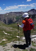
First up, getting to the top of Bell Rock. Joe picked a decent ascent route to the top. There are only a couple spots that make you think a bit. We had the top to ourselves. Great morning views of the area.

Video from the top :next: youtu.be/51Jch9Byq18

Next up, an area that's off the main drag. I've wanted to get a better view of the "Rabbit Ears" and found this unmarked loop on Satellite View that get's you close. We saw one mountain biker, walking her bike on the trail and that was it. A nice little change from the perfectly groomed Sedona main corridor trails.

Just before making it to Chicken Point, I lost Joe to a Yoga Class for a bit.

The High on the Hog and Hog Heaven Trails need to be put on your list if you are in this area. We were calling this the Hangover junior Trail. Great trail with great views.

After taking Joe to church, it was off to Cathedral Rock. The HT Trail and Templeton Trails are a worthy alternatives to reaching Cathedral Rock. Being one of the most popular areas in Sedona, it was jumping with all types. Including Infants, puppies, yoga pants and Grandmas.

I really enjoyed this loop with perfect weather in gods country.
 Meteorology
 Meteorology [ checklist ]
[ checklist ]  Moon
_____________________
There is a very fine line between "hobby" and "mental illness."
Dave Barry 🦅
 
Nov 12 2016
avatar

 Guides 264
 Routes 2,797
 Photos 14,494
 Triplogs 5,894

55 male
 Joined Nov 20 1996
 
Bell Rabbit Chicken Hog Church Cathedral, AZ 
Bell Rabbit Chicken Hog Church Cathedral, AZ
 
Hiking avatar Nov 12 2016
joebartelsTriplogs 5,894
Hiking20.02 Miles 3,522 AEG
Hiking20.02 Miles   9 Hrs   45 Mns   2.25 mph
3,522 ft AEG      50 Mns Break14 LBS Pack
 
1st trip
Bell Rock
Hands down the highlight. Using 9L's posted route it was easy to decipher. Based on the tunnel through the scrub at the bottom and the register up top this place gets a lot of visitors.

Rabbit Ears
Heard of this 11 years ago and have been mildly curious. I prefer the north part of the loop over the south. Once is probably enough. It's cool you can see the ears driving south on I-17!

The Hogs
16 years ago I mountain biked Broken Arrow. Memories of so so kept it off my return list. The Hog trails are near perfect. A low key manicured version of Hangover Trail ( favorite ). Edgy trail through lots of cypress, need I say more. Thx to tibber/gecko for bringing these great trails to light.

Templeton Trail
Bruce put this hike together. I suggested the missing spice Cathedral Rock utilizing HT & Templeton to connect. Unexpectedly found out the connectors are decent hiking. When you aren't in the cypress you are surrounded by the distant red rock formations. This trail goes to Red Rock Crossing, I may have under estimated it's potential. Tough to give it a higher rating going under a hwy and with such other great choices nearby. Let's call it a high 3.9 of 5!

Synopsis
I enjoyed the entire hike. Sedona, the forest service or whoever has done a great job with most of the trails and signage. I'm not a fan of over networked trail systems like the cough north McDowells. It works very well in this spectacular land of red rock. Wonderful weather and friendly yoga enthusiast may have made this hike better than normal.
 Culture
 Culture [ checklist ]
[ checklist ]  Route - finding Labels
_____________________
- joe
 
Sep 25 2016
avatar

 Photos 418
 Triplogs 169

female
 Joined Jul 22 2016
 Sedona, AZ
Courthouse Butte Loop TrailSedona, AZ
Sedona, AZ
 Run/Jog avatar Sep 25 2016
xthineTriplogs 169
 Run/Jog5.86 Miles 545 AEG
 Run/Jog5.86 Miles   1 Hour   26 Mns   31 Secs4.06 mph
545 ft AEG
 no routes
Linked   linked  
Partners none no partners
_____________________
  1 archive
Aug 21 2016
avatar

 Photos 418
 Triplogs 169

female
 Joined Jul 22 2016
 Sedona, AZ
Courthouse Butte Loop TrailSedona, AZ
Sedona, AZ
 Run/Jog avatar Aug 21 2016
xthineTriplogs 169
 Run/Jog4.00 Miles 440 AEG
 Run/Jog4.00 Miles   1 Hour   24 Mns   2.86 mph
440 ft AEG
 no routes
Linked   linked  
Partners none no partners
Overcast and mid 70s. Finally got to try a more trail running friendly route. Decided against scrambling up Bell Rock today.
_____________________
 
average hiking speed 2.41 mph

WARNING! Hiking and outdoor related sports can be dangerous. Be responsible and prepare for the trip. Study the area you are entering and plan accordingly. Dress for the current and unexpected weather changes. Take plenty of water. Never go alone. Make an itinerary with your plan(s), route(s), destination(s) and expected return time. Give your itinerary to trusted family and/or friends.

helpcommentissue

end of page marker