username
X
password
register
for free!
help
ArticlesGuidesRoutes
 
Photosets
 
 Comments
triplogs   photosets   labels comments more
Superstition Peak 5057 from Lost Dutchman - 4 members in 17 triplogs have rated this an average 4.3 ( 1 to 5 best )
17 triplogs
login for filter options
Mar 16 2024
avatar

 Routes 137
 Photos 1
 Triplogs 105

44 female
 Joined Oct 21 2016
 Tempe, AZ
Superstition RidgelinePhoenix, AZ
Phoenix, AZ
Hiking avatar Mar 16 2024
MAPTriplogs 105
Hiking11.31 Miles 4,174 AEG
Hiking11.31 Miles   11 Hrs   11 Mns   1.12 mph
4,174 ft AEG   1 Hour   4 Mns Break
 
no photosets
1st trip
Perfect weather day during the roller coaster of weather we've been having this March! I couldn't have been more lucky. A group of friends had planned to hike the Ridgeline & I tagged along last minute. All the usual fun going up Siphon Draw. I made a quick stop at 5024 while my friends took a break. Continued on along the Ridgeline, taking wrong trails here & there. There are a lot more trails along the Ridgeline from the last time I hiked it. We would follow one for a bit, it would become clear that the route became impassable or unnecessarily dangerous and we would backtrack and a very well-used trail would appear. I made another quick stop at 5057 while my friends waited and I found a letter in a bottle hidden under a boulder at the summit (but no ammo box and no summit log). The letter in the bottle was numbered #9. I wonder what other peaks letters are hidden at. Caught back up with my friends and we oohed and ahhed at the "raging river" of water flowing along the north side of the trail as we made our way towards Carney Springs trail.

water 1 out of 5water 2 out of 5water 3 out of 5water less than max Boulder Creek Origin - Ridgeline Route Medium flow Medium flow

water 1 out of 5water 2 out of 5water less than maxwater less than max Siphon Draw Waterfall Light flow Light flow
_____________________
 
Feb 24 2023
avatar

 Guides 59
 Routes 1,100
 Photos 1,191
 Triplogs 1,290

male
 Joined Jan 01 2023
 Arizona
Shaka Cave from Lost Dutchman, AZ 
Shaka Cave from Lost Dutchman, AZ
 
Hiking avatar Feb 24 2023
pseudalpineTriplogs 1,290
Hiking22.22 Miles 9,456 AEG
Hiking22.22 Miles   12 Hrs   53 Mns   1.97 mph
9,456 ft AEG   1 Hour   37 Mns Break
 
1st trip
Route Scout Route Recorded  on Route Scout | Pop | Map | Popup | MapDEX
AKA Superstition Ridgeline YoYo
 Flora
 Flora [ checklist ]
[ checklist ]  Saguaro
  6 archives
Feb 29 2020
avatar

 Guides 99
 Routes 1,484
 Photos 16,072
 Triplogs 1,374

male
 Joined Jan 07 2017
 Fountain Hills,
Superstition Peak 5057 from Lost DutchmanPhoenix, AZ
Phoenix, AZ
Hiking avatar Feb 29 2020
DixieFlyerTriplogs 1,374
Hiking17.20 Miles 6,355 AEG
Hiking17.20 Miles   10 Hrs   41 Mns   1.88 mph
6,355 ft AEG   1 Hour   33 Mns Break
 
1st trip
Partners none no partners
Yesterday I decided to do my annual rite of spring hike from Lost Dutchman State Park to Peak 5057 and back.

This is a tough day hike -- I'd say that it is perhaps more strenuous than a rim-to-rim hike in the Grand Canyon.

There were quite a few people up on the ridgeline yesterday -- more than I think that I have ever seen. Strangely, there weren't too many people going up Flatiron though.

It's always great being up on the Superstition Ridgeline, and this hike traversed the best parts of the ridgeline twice.
 Geology
 Geology [ checklist ]
[ checklist ]  HooDoo
wildflower observationwildflower observationwildflower observationwildflower observationwildflower observation
Wildflowers Observation Light
Wildflowers up on the ridgeline were light -- there were a few Dichelostemma capitatum, goodings verbena, western wallflower, and Indian paintbrush. The flowers along the Siphon Draw Trail were more in the moderate category -- in particular the brittlebush, globemallow, and chuparosa looked really good.

water 1 out of 5water less than maxwater less than maxwater less than max Siphon Draw Waterfall Pools to trickle Pools to trickle
There is still a bit of water in Siphon Draw from the rain last weekend, but there really isn't much to see at this point.
_____________________
Civilization is a nice place to visit but I wouldn't want to live there
  3 archives
Feb 23 2020
avatar

 Guides 94
 Routes 840
 Photos 22,055
 Triplogs 1,993

52 male
 Joined Sep 18 2002
 Tempe, AZ
Superstition RidgelinePhoenix, AZ
Phoenix, AZ
Hiking avatar Feb 23 2020
chumleyTriplogs 1,993
Hiking13.96 Miles 4,837 AEG
Hiking13.96 Miles   8 Hrs   25 Mns   1.66 mph
4,837 ft AEG
 
Met Karl at Peralta. That was fun! Good flow in 5 crossings. Only h/c trucks were making it through. Left a truck and drove back around to First Water, where the instagram massacre was in full swing. It's a rare day I'm happy to deal with the shyteshow in Siphon, but it was def better than the reverse. Good water flow in the draw the whole way. It was a river, and there were plenty of falls feeding it from all sides above.

Reached the top and skipped both 24 and the board. The forecast completely failed, as it got more and more cloudy, socked in, windy, and chillier than planned. And still, a beautiful day! :y: I could not believe how much water there was on the ridgeline. Where does it come from? I can see the highpoint 12 feet on my left and still there's a steady stream of water flowing down! :sweat:

Good time going across, knocking down countless useless cairns along the way (plenty of helpful ones were unharmed!) Are the people who build them stupid, or do they think everybody else is stupid? Or do they build them out of boredom? Got into a fun argument with some folks at heiro who apparently would not have been able to find the saddle, nor the canyon, without a pile of rocks! (Other) Kyle has anger management issues. Lol. :sweat:

Enjoyed a beer on 5057 as the sun tried to make an appearance and the wind had given us a break. Over at the Carney Saddle we met up with Patrick and Justin and decided to skip the Robbers Dacite route back, instead going straight down. There were a couple of great waterfalls here too, including one that was easily 250 feet. Would have been impressive to see yesterday.

Supes in rare form today. Glad to have spent a few hours out there. Thanks for helping shuttle Karl!

water 1 out of 5water 2 out of 5water 3 out of 5water less than max Boulder Creek Origin - Ridgeline Route Medium flow Medium flow

water 1 out of 5water 2 out of 5water 3 out of 5water less than max Siphon Draw Waterfall Medium flow Medium flow
_____________________
I'm not sure what my spirit animal is, but I'm confident it has rabies.
  3 archives
Mar 02 2019
avatar

 Guides 99
 Routes 1,484
 Photos 16,072
 Triplogs 1,374

male
 Joined Jan 07 2017
 Fountain Hills,
Superstition RidgelinePhoenix, AZ
Phoenix, AZ
Hiking avatar Mar 02 2019
DixieFlyerTriplogs 1,374
Hiking17.10 Miles 6,010 AEG
Hiking17.10 Miles   10 Hrs   33 Mns   2.19 mph
6,010 ft AEG   2 Hrs   44 Mns Break
 
no photosets
1st trip
Partners none no partners
I decided that today would be a good day to be up on the Superstition Ridgeline, and we did a variation of the ridgeline hike by going from the Siphon Draw TH in Lost Dutchman State Park up to Peak 5057, and then turning around and doubling back to the Siphon Draw TH. This was a tough little hike: in addition to the distance and elevation gain, there was quite a bit of rock scrambling.

There was not much snow left, and it was not an issue on the hike.

On the way we bagged Peak 4869, which was not much trouble to do since the summit was only 50 feet or so from the trail.
_____________________
Civilization is a nice place to visit but I wouldn't want to live there
 
Jan 22 2019
avatar

 Guides 94
 Routes 840
 Photos 22,055
 Triplogs 1,993

52 male
 Joined Sep 18 2002
 Tempe, AZ
Superstition RidgelinePhoenix, AZ
Phoenix, AZ
Hiking avatar Jan 22 2019
chumleyTriplogs 1,993
Hiking13.96 Miles 4,837 AEG
Hiking13.96 Miles   8 Hrs   41 Mns   1.87 mph
4,837 ft AEG   1 Hour   12 Mns Break
 
I had plans to go to California, but glad I decided on this instead. :y:

At 30, it was chilly to start. Otherwise, pretty ideal conditions today. Pretty much perfect in my book. Saw a group of 6 others on the same route who we caught up with and eventually passed below 5057. Four others on the initial climb up siphon, and a handful of wave cavers at the end. Peaceful day otherwise.

Peralta rd is in pristine condition. First Water not so much. A couple of drainages south of 5024 had a bit of water. Plenty in upper Boulder and the eastern tributary below the saddle.

We took an off-trail route off 5024 and I'd say it's easier than the "official" route from the top of siphon draw. No track on haz so I'll post that part of it so it shows up on the map. It's not a route, but isn't a bad option if you don't mind a little desert pinball.

@tortoise_hiker tells me that like HAZ, Joe rocks. Tough to argue with that!

Good to finally hike with rt. Thanks for posting the event! :app:

(made sure to add a mile and some aeg 'cause that's how I always do this hike!)
 Culture
 Culture [ checklist ]
[ checklist ]  Benchmark
_____________________
I'm not sure what my spirit animal is, but I'm confident it has rabies.
  1 archive
Jan 22 2019
avatar

 Guides 264
 Routes 2,797
 Photos 14,494
 Triplogs 5,894

55 male
 Joined Nov 20 1996
 
Superstition RidgelinePhoenix, AZ
Phoenix, AZ
Hiking avatar Jan 22 2019
joebartelsTriplogs 5,894
Hiking13.12 Miles 4,889 AEG
Hiking13.12 Miles   8 Hrs   41 Mns   1.87 mph
4,889 ft AEG   1 Hour   41 Mns Break6 LBS Pack
 
Route Scout Route Recorded  on Route Scout | Pop | Map | Popup | MapDEX
One of the best hikes near the valley.
Great hike, better company & perfect weather.
wildflower observationwildflower observationwildflower observationwildflower observationwildflower observation
Wildflowers Observation Isolated

water 1 out of 5water less than maxwater less than maxwater less than max Boulder Creek Origin - Ridgeline Route Pools to trickle Pools to trickle
Large clear pools.
Creek was running far below in boulder too.
_____________________
- joe
 
Jan 22 2019
avatar

 Guides 110
 Routes 2,246
 Photos 8,982
 Triplogs 2,600

45 female
 Joined Dec 24 2007
 Ahwatukee, AZ
Superstition RidgelinePhoenix, AZ
Phoenix, AZ
Hiking avatar Jan 22 2019
LindaAnnTriplogs 2,600
Hiking12.86 Miles 4,753 AEG
Hiking12.86 Miles   8 Hrs   41 Mns   1.79 mph
4,753 ft AEG   1 Hour   29 Mns Break
 
After setting up the shuttle, we got to the Crosscut trailhead just before 8:00, and started a few minutes later. Starting on Jacob's Trail was a nice way to warm up, and I shed the long sleeve shirt a little while later on Siphon. Siphon Draw was pretty much deserted. There are new black X's marking the way, grrr, but at least they managed to place them along the best route most of the way.

Most of us headed over to 5024, and told Mark we would meet him back on the ridgeline on the other side of the peak. Dropping off the east side of 5024 wasn't too bad. It was steep, and I nearly hugged a cholla at one point, but we all stayed upright and cactus-free. Views were great along the ridgeline. Somewhere around the middle, we took a slightly different route than I have historically used. I think the way I've gone before was a little easier, but it didn't matter, because after about 10 minutes, it all led to the same place. We found a spot with some good seating and views for lunch, and it was nice to rest the legs for a few minutes.

I felt like I dragged a little during some of the rougher parts in the half mile or so before the chute at the north end of 5057, but was happier once the terrain smoothed out. We ran into another group taking a break where we turned to head up to 5057. They had started about an hour before us, and probably finished about 30 minutes after we did. I never mind the last little uphill section up to West Boulder, but descending down to Carney is something I try not to do too often. The mile or so along Lost Goldmine went quickly, and was very well signed, but the Wave Cave crowd is still determined to get lost on their journeys for the perfect instagram photo. Nice to meet Alex, and to see Mark again-- I think our only hike together was about two years ago. Great day, and perfect weather for this hike.

water 1 out of 5water less than maxwater less than maxwater less than max Boulder Creek Origin - Ridgeline Route Pools to trickle Pools to trickle
Large pools of water.
_____________________
Stop crying and just go do the hike.
  1 archive
Jan 12 2019
avatar

 Guides 69
 Routes 37
 Photos 3,010
 Triplogs 2,387

55 male
 Joined Oct 24 2010
 Phoenix,Az
Superstition Peak 5057 from Lost DutchmanPhoenix, AZ
Phoenix, AZ
Hiking avatar Jan 12 2019
mt98dewTriplogs 2,387
Hiking19.16 Miles 6,157 AEG
Hiking19.16 Miles   9 Hrs   22 Mns   2.05 mph
6,157 ft AEG
 no routesno photosets
1st trip
Linked   none no linked trail guides
Partners none no partners
:sweat: :sweat: This kicked my :pk: . That being said I came out better than my shorts. I had a major "wardrobe" malfunction that I noticed around mile 8. I had a 4 inch rip (that developed into an 8 inch rip) that went down the entire length of the front of my shorts. I was :oops: . But I figured, who's going to notice. I'm on the Supe ridgeline. How many people am I going to run into? Answer 43. It was a freaking highway up there. ](*,)

I had left the parking area on First Water Road just of the 88 a little before 6am. Skies were dark and there was a decent breeze which made for cool temps that caused me to bring my jacket (thank goodness!). Took a user trail to Jacob's Crosscut to Siphon and then up to the Flat Iron. Had darkness for a solid hour, before the sunrise began to illuminate the trail. Didn't see a soul until I reached the Flat Iron, where I saw two people who had camped up there overnight. From there I hit the ridgeline. The trail is in amazingly good shape (go figure....43 people!). Had no trouble following it...or at least, a version of it. Discovered in doing this as an in and out that there are a couple of threads to the ridgeline. Not a huge deal. The "threads"/paths that I did were well established and tied back into other as the elevation changed. Didn't see my first hiker on the ridgeline until I hit the peak....and it was packed! There were 6 people on the peak when I got there and I met 7 others in various spots along the final climb! I think most of the people were part of one large family. And they were estatic about reaching the summit....loudly estatic. I kid you not, I was at least an hour away and I could still hear their shouts and screams. :-$ I get it. It is quite the accomplishment....but for any other hiker who wanted to enjoy the peak and the experience....

The Flat Iron was busy, as I expected, after experiencing the crowds on the ridgeline. There were occasional bottlenecks, but the flow was much better than I anticipated. It was a little challenging descending as I carried my jacket in one hand trying to strategically place it in front of me so as not offend the masses. I actually think the descent went incredibly smoothly...all things considered.

Water was trickling in the Siphon, in a couple of spots on the Flat Iron ascent and also in a couple of spots on the ridgeline. Sweet! Saw 4 deer on the ridge. Tried to get a picture of one, but it was moving. So I am not sure how that turned out. Weather was awesome. Overcast for the majority of it, but it cleared up over the last couple of hours. Glad to check this off the box :sweat:
_____________________
 
Jan 20 2018
avatar

 Guides 6
 Routes 23
 Photos 1,125
 Triplogs 593

46 male
 Joined May 23 2012
 Mesa, AZ
Superstition Peak 5057 from Lost DutchmanPhoenix, AZ
Phoenix, AZ
Hiking avatar Jan 20 2018
syoungTriplogs 593
Hiking16.56 Miles 6,161 AEG
Hiking16.56 Miles   5 Hrs   41 Mns   2.91 mph
6,161 ft AEG
 
With the promise of some not quite Arizona friendly weather I decided to enjoy it by trekking across the ridgeline and back. I got a start around 6:10 from Lost Dutchman. It was incredibly windy all the way to the basin. From there until the ridgeline the mountain absorbed any winds being sent towards me. I changed out of my trail runners at the basin and threw on my approach shoes for the climb up to the second saddle. I usually switch back to trail runners when heading out onto the ridgeline but decided to stay in the approach shoes. Turns out I pounded out the rest of the trip in them.

The return trip back to Lost Dutchman was a race against the approaching weather, which I lost. Ducking down from the Second Saddle to return to the basin and the skies opened up on me again.

_____________________
 
Jan 20 2018
avatar

 Guides 4
 Routes 491
 Photos 10,890
 Triplogs 1,257

55 male
 Joined Nov 20 2012
 Phoenix, AZ
Superstition RidgelinePhoenix, AZ
Phoenix, AZ
Hiking avatar Jan 20 2018
BiFrostTriplogs 1,257
Hiking11.54 Miles 4,943 AEG
Hiking11.54 Miles   6 Hrs   27 Mns   1.95 mph
4,943 ft AEG      32 Mns Break
 
Partners partners
chumley
John9L
Joined Chumley and 9L for some ridgeline fun. Weather forecast was for rain which we were hoping to see some during the hike. Started from Miners Camp site with shuttle drop off from SuperstitionGuy...thank you :D Then up Siphon with the usual crowd past Flat Iron. Once on the ridgeline it was great to be on the spine. There were a few others but not bad...ran into syoung on the traverse going the other direction and talked to him for several minutes. The rain was light as we took a break on 5057. After that we headed down and the rain started a bit harder but it was never uncomfortable. Clouds formations were cool as we started the descent to Carney TH. Made the TH in good time and another solid hike!!
_____________________
  1 archive
Jan 20 2018
avatar

 Guides 94
 Routes 840
 Photos 22,055
 Triplogs 1,993

52 male
 Joined Sep 18 2002
 Tempe, AZ
Superstition RidgelinePhoenix, AZ
Phoenix, AZ
Hiking avatar Jan 20 2018
chumleyTriplogs 1,993
Hiking11.54 Miles 4,943 AEG
Hiking11.54 Miles   6 Hrs   27 Mns   1.95 mph
4,943 ft AEG      32 Mns Break
 
Partners partners
BiFrost
John9L
In anticipation of some interesting weather, we headed out on the spine of the superstitions hoping to encounter a little rain, clouds, and maybe some snow.

It was a great day to be out but the weather only provided a few periods of light rain. No snow, and we were off the spine before the most dramatic clouds of the day socked in. Oh well. It was a great day to be up there. I really enjoy seeing these places when they're not clear and sunny. You can find that pretty much any time you want!

I always enjoy this one, and as usual, it kicked my butt. It was nice to finally put a face to the superstitionguy avatar who helped us out with the shuttle. Thanks!
 Culture
 Culture [ checklist ]
[ checklist ]  HAZ - Selfie
_____________________
I'm not sure what my spirit animal is, but I'm confident it has rabies.
 
Apr 29 2017
avatar

 Guides 6
 Routes 23
 Photos 1,125
 Triplogs 593

46 male
 Joined May 23 2012
 Mesa, AZ
Superstition Peak 5057 from Lost DutchmanPhoenix, AZ
Phoenix, AZ
Hiking avatar Apr 29 2017
syoungTriplogs 593
Hiking17.01 Miles 5,807 AEG
Hiking17.01 Miles   6 Hrs   56 Mns   2.68 mph
5,807 ft AEG      35 Mns Break24 LBS Pack
 
Partners none no partners
Today seemed like the perfect time to check this one off of the list; and probably the last day I'd have the weather on my side to do it before Kilimanjaro. I started up around 7ish in the morning. Ran into a few familiar faces on the way up.

Reaching the second saddle I had a bit of difficulty locating the actual trail. Everything is so overgrown that it makes it hard to see. I started cruising once I found the trail and made it to 5057 in a little over 3 hours. I hung out on top of 5057 for a few minutes then made haste on my way back.

I unfortunately had a run in with a cacti and had to pull up to pull out the spines. It was just superficial damage and away I went as I still had several miles to cover. I reached the point of the ridgeline that I believe is the most photogenic and reach for camera, that was attached to my hip belt... but wasn't there. It had fallen off during the pit stop and now I was faced with the daunting task of retracing my steps to find it. I made my way back through the barren slick rock section about a mile from 5057, trying to retrace my steps. I couldn't find it and decided to turn back and follow the trail as best I could... and about a minute later, there it was. Disaster avoided.

I really need to come up with a better strategy for these high AEG hikes. I cramp up something fierce on these. If I picked my leg up past a certain point it would start to cramp. I drunk 32oz of powerade and a ton of water, 2 packages of gu, and several of the honeycomb thingamabobs. It is something I hope to solve before Kilimanjaro as the summit night is something like 15+ miles and 4k of AEG in the first handful of miles.
 Culture
 Culture [ checklist ]
[ checklist ]  Benchmark
_____________________
  1 archive
Feb 08 2014
avatar

 Guides 1
 Routes 148
 Photos 9,924
 Triplogs 3,652

63 male
 Joined Apr 02 2005
 Mesa, AZ
Superstition 5057 via Siphon Draw Az, AZ 
Superstition 5057 via Siphon Draw Az, AZ
 
Hiking avatar Feb 08 2014
Tortoise_HikerTriplogs 3,652
Hiking15.56 Miles 6,116 AEG
Hiking15.56 Miles   7 Hrs   11 Mns   2.17 mph
6,116 ft AEG
 no routes
1st trip
I Asked JJ a couple questions about this hike and if wanted to go with. :o He said yes and I was locked in :) . JJ gave me a head start and I wore myself out trying to make time up the Flatiron. From there he took it easy on me but I still made the peak in 3.5 hours :D . I'll take it. The clouds keep the Sun at bay somewhat and the views were GREAT! We did see more people on the Ridgeline then we ever have. There were 3 groups of 15 comming from Carney and lots of others.
I was wearing down on the way back but the views were still GREAT! JJ wanted to do 5024 but I was beat and my stomach was getting upset with me so I took a break while he did it. He did manage to get me on the Flatiron for a sec. JJ noticed a big group getting ready to head down so we headed down so we didn't get stuck behind them. I mentione maybe making it in 7 hours but just didn't have it in me. JJ made it with a few minutes to spare. I was surprised to see a few Deer towards the bottom of Siphon on the southside even with all the people on trail.
Thanks for the hike and Slurpee JJ. It was a butt- kicker!
_____________________
Tortoise Hiking. Stop and smell the Petrichor.
 
Mar 12 2012
avatar

 Guides 21
 Routes 1,182
 Photos 36,858
 Triplogs 1,570

69 female
 Joined Feb 26 2004
 Phoenix, AZ
Superstition RidgelinePhoenix, AZ
Phoenix, AZ
Hiking avatar Mar 12 2012
tibberTriplogs 1,570
Hiking11.25 Miles 4,545 AEG
Hiking11.25 Miles   13 Hrs   49 Mns   1.50 mph
4,545 ft AEG   6 Hrs   18 Mns Break
 
1st trip
Where to start 8-[ ? First, this hike lived up to its reputation and then some :worthy: . The hike itself is hard and spectacular in so many ways. Unfortunately, the day got off to a bad start due to logistic issues which you can find in Kat and Wendy's reports. Initially Wendy's friend Tiffani was going to lead us up via Carney. All of my research for this hike was from Carney. But as it would turn out, Tiffani's back was having issues so I asked Kat if she would lead us.
Kat agreed to take us on the Ridgeline tour. I thot it would be great fun to hike with two of my mentors. Well it almost worked out but not quite. That's just the way life goes sometimes.

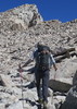
We got started from the Mining Camp restaurant. I had forgotten how gradually relentless the walk up Siphon Draw is until you start getting closer to the Basin. Sam and Kat were ahead and every once in awhile they would slow enough or stop long enough for me to catch up. This would also be the case for the Flatiron portion of this hike. They encouraged me and Kat said I was doing great.

It was nice hiking up the Flatiron in the shade. We didn't stop for more than a minute or two from time to time steadily making our way up the Basin :sweat: and above to the first saddle before you head down and then up and up and up : rambo : . WOW that's tough. I did a short lead for about 10 minutes after we exited the basin. I like scrambling cuz you don't have to go fast.

Once again, during the climbing section after the saddle, I would see Kat and Sam pause to see if I was still coming. They would also offer directional advise in the trickier sections. That's always a nice thing as I just want to concentrate on using my body, not my brain :D . I don't want to wear everything out in the beginning of the hike :lol: . In a PM, Kat had asked me if I thot I could make it up in 2 hours :o and I told her NO WAY; I would be lucky if I could make it in 2 1/2. I made it in 3. That's about what it took me to climb Picketpost with a couple stops. Today, basically no stops. There was also a surprising amount of traffic for a Monday but it was spring break too.

This time I used the tree to get over the shelf or wall and then, as you know, the saddle is just about right there. Now it was a matter of waiting for Wendy to catch up. I walked over to the boulders on the NW side and peered over with my camera's max telephoto engaged. Believe it or not, I eventually saw her. I threw a Wendy and yelled down to her. About 30 minutes later, Wendy reached the saddle and after a 15 min break or so we met up with Kat at the top of the saddle before heading down onto the Ridgeline.

I had never seen this part of the Ridgeline as when I was here last, the clouds were low and we headed up Peak 5024. I had seen pics of it before with those beautiful pine trees. We were walking at a pretty good clip as we were about an hour or so behind Kat's schedule. Kat showed us the point to go see Monument Canyon. We hiked for about another mile in a east(?) than south direction skirting the top of the canyon on the right. It's really a neat area. I spotted a guy atop one of the peaks sitting next to a US flag; I zoomed in and got his picture.

We eventually caught up with Kat again and she expressed her concern for our pace and getting done before dark 8-[ . I really didn't want to turn around, especially after coming up :yuck: that beastly Flatiron. Sam and Wendy did not want to retreat either. Kat just wasn't comfortable and she decided to go back. With Sam's GPS now fully engaged, off we went to finish one of the greatest hikes in the Superstitions. I had been hiking my heart out to be able to do this.

It was great fun seeing what was at the top of each hill or climb and to guess where the trail may be going. The views were nothing short of stupendous :y: especially when you could see over both sides as you walked the top of the ridgeline. You can almost see the entire time where you're headed (Superstition Peak) but getting there was full of challenges and elation. Needless to say, the favorite part is when you can walk and gawk.

One time I heard from Sam who was up ahead, "how about a picture break here?!" Huh, what?! Okay. Sam then became my favorite trip leader :) . I was glad that he liked to take pictures and it would put a few moments of slow in his giddyup. We broke for lunch at a most incredible place on some bedrock on the ridgeline with totally cool views both ways. It was always a joy to see Weavers Needle for so much of this trip. And when Black Mesa came into view as well as Black Top Mesa and Bluff Spring Mountain and the Peralta Ridgeline and Malapais and Peters Mesa and Tortilla and Music Mountains... it's just almost too much to have to absorb in a fast pace from the Ridgeline.

We eventually made a navigational error but no one was alarmed or nervous about it. We were all just mad at ourselves for missing the cairn that said "go right" :oops: . We knew the route was well cairned and the moment we started not seeing as many :doh: , we should have gone back. The area that we came back to and hiked along was so cool too as you make your way along the bedrock side and then climb up again to get on top of the Ridgeline. I told Sam that when he came to a cool view to say "whoo hoo" and that would be an incentive for me to hike a little faster knowing a picture moment was ahead.

It only got warm a couple times but we would be on the south side or climbing the ridgeline. Our next dilemma came when we hit the slot and Sam says, where do we go now :-k . Wendy spotted the cairns. That's nice but "how do we get UP there". She spotted a nook that had a bit of a ledge and UP she climbed. It's getting later in the day but we all had a blast with this little climb :DANCE: .
And then, THERE we were: at the foot of Peak 5057 summit route. The view back the way we had come, OMG!!! :y: Being low on time we didn't get to relish this moment so off we went. We got a little off the trail here but within 5 minutes or so got back on with the help of Sam's GPS. By this time he was getting quite good : app : at following the GPS.

It was a great hike coming off of 5057 as we headed toward the 3 Sisters. Of course I'm thinking, oh look, the saddle should be just around that big corner but then when I consulted the mileage I realized, "not quite" as we still had more to go down yet. I liked passing thru the cairn gate as it was a beautiful time of the afternoon for that. Soon we came to a fork in the trail but true to his GPS route, we went right and :gun: UP another hill. You can skirt around to the NE as the trails will meet up at the same place.

By this time we were in the shade of the mountain and slowly losing our light but nothing too bad yet.... UNTIL... Wendy said howdy doody to a prickly pear cactus :stretch: . To say she was overly friendly, you would have had to seen the amount of needles in her clothing, hence her body - mostly her derrier. We were just having a conversation about falling... Anyway, I got out my tweezers and found that my fingernails worked well too.
Wendy did have to drop her drawers completely for me to get the thorns that were deeper in. There was no way we were going to get them all out so after 20 minutes, she put on my shirt and I put on my windbreaker and she pulled her pants back up [-( and off we went. For the rest of the trip I heard an occasional "ouch" as so many of those thorns were reminding her they were still there.

We finally got down to the fun section with the bedrock and rock outcroppings and such. The light was still lingering and some of the paintbrush were just incredible but no time to stop and take a photo. I had pretty much retired my camera anyway. We came around this one area where the rock walls across the basin to the south were lit up beautifully by the setting sun so we did grab some photos there. We eventually arrived at Carney Saddle just as it was about dark.

Then it was time for Plan A, call Jack :pray: . He lived the closest and I knew he was very familiar with the TH. I get him on the line and he says "who? what? where?" "REALLY?!". The conversation closed with "see you in a couple hours" and down we went in the dark.
I knew going down we would eventually reach the false saddle where we could walk up-right for a few minutes before proceeding down the last part of Carney. It actually wasn't too bad going down in the dark cuz you couldn't really tell how steep it was AND you couldn't see how far you had left to go :) .

The only thing that was annoying were the stupid bugs flying around the light and when you would go to swish them away, you could lose your footing so I tried to concentrate and just let them annoy me ](*,) . Let me tell you, I was glad I had my trekking poles as they helped so much with balance and footing while coming down Carney. Sometime as we were coming down I saw Jack's truck pull up to the TH; that was very comforting (I just knew he would be early). Two things of note, that one big saguaro looks awesome with your headlight on it :D and once you get to that mushroom rock (though hard to identify at nite), you're almost home free.

As we start walking on the road we see a light and I bet it was Jack. Now how about that, our trail :A1: not only came out to rescue us, he came almost all the way up the jeep road to greet us. But it gets better, when we get to the truck, we get a beer in a kozy : app : and chocolate cupcakes plus he wants to take a pic of us. You all should be so lucky to have this kind of trail angel at your beckon call. :thanx: JACK!

We had a great drive back as Jack is very knowledgeable about the Supes so we shared some stories and before you knew it, we were at the Mining Camp Restaurant. We exchanged good- byes. I was surprised to hear Sam say to me, "I look forward to our next hike together". Mind you, he hadn't really led a hike like this before where he had to rely somewhat on the GPS to keep us on track nor had he hiked in the dark, nor had he hiked with 3 crazy women on such a hard hike :whistle: . So Sam, "I look forward to our next hike too!"

I am perplexed as normally after such a grueling hike it takes awhile to say, "yep, I'm ready to do it again" but already this week, "I'm ready to do it again". However, it looks like the temps will prevent this until Fall and then I want to try it from Carney. Can't wait!

Here is a little video from our trek across THE ridgeline: http://youtu.be/vwsKQXFC85k I updated the video as I was unhappy with the quality of the first one so hopefully this will be better.

PS(1): You know, accomplishing this hike was a major milestone. I tell my family and my friends and they say "how nice". They have no clue. And that is when I realized :SB: , it's good to have HAZ and HAZ friends because they know this is a wonderfully hard hike to complete. So thank you for letting me share and thanks for sharing.
PS(2): Sam didn't require much training for tibbermode because when I would yell his name, he would turn and smile as he knew there was a good chance I was wanting a picture.
_____________________
For me, sometimes it's just as much about the journey as the destination.
Oh, and once in awhile, don't forget to look back at the trail you've traveled.
 
Dec 20 2008
avatar

 Guides 16
 Routes 81
 Photos 1,269
 Triplogs 1,144

51 male
 Joined Apr 30 2008
 Tucson, AZ
Superstition RidgelinePhoenix, AZ
Phoenix, AZ
Hiking avatar Dec 20 2008
azdesertfatherTriplogs 1,144
Hiking12.03 Miles 4,731 AEG
Hiking12.03 Miles   8 Hrs      1.50 mph
4,731 ft AEG
 
1st trip
Couldn't have asked for better weather today. Sunny, clear, perfect temps. Great company, too. Started off at Carney Springs TH, ended up at Lost Dutchman SP. While tackling the ridgeline, we also summitted Superstition Mountain (Peak 5057) and Peak 5024 at the end of Siphon Draw Trail.

For those of you in the group who were placing bets on how many blisters I would end up getting while breaking in a brand-new paper of hiking boots from Wally World (aka WalMart), your answer is 0! (Doubled boot socks on each foot...works every time!) Wasn't the brightest thing to do, but I've worn out another pair of boots and haven't been able to do another smaller hike since. I reglued the soles on the pair I had to duct tape to get through the Camelback Cholla TH-peak-Echo Canyon TH-peak-Cholla TH, but I didn't want to risk the boots turning into flip flops again on the ridgeline! :sl:

Secrets discovered: If going out with rally_toad, make sure he does a long, exhausting hike the day before you go out with them...then you can keep up with him. ;) If with rushthezeppelin? Take him steep elevation and deny him bananas. What to do about wallyfarak? That secret has yet to be discovered...maybe cryptonite needs to be involved...

Difficulty (for me): :sweat: :sweat: :sweat: :sweat: :sweat: (of 5)
 Flora
 Flora [ checklist ]
[ checklist ]  Century Plant
 Geology
 Geology [ checklist ]
[ checklist ]  HooDoo
_____________________
"I went to the woods because I wished to live deliberately, to front only the essential facts of life, and see if I could not learn what it had to teach, and not, when I came to die, discover that I had not lived." — Henry David Thoreau
  1 archive
Dec 20 2008
avatar

 Guides 2
 Routes 251
 Photos 4,593
 Triplogs 3,212

63 male
 Joined Feb 26 2008
 Scottsdale, AZ
Superstition RidgelinePhoenix, AZ
Phoenix, AZ
Hiking avatar Dec 20 2008
BobPTriplogs 3,212
Hiking11.50 Miles 4,480 AEG
Hiking11.50 Miles   8 Hrs      1.44 mph
4,480 ft AEG
 no routes
Partners 7 partners
azdesertfather
pace
rally_toad
rushthezeppelin
sardesign
Tortoise_Hiker
wallyfrack
I just saw a thread about this hike and noticed I never logged it.
_____________________
https://www.seeitourway.org
Always pronounce Egeszsegedre properly......
If you like this triplog you must be a friend of BrunoP
 
average hiking speed 1.91 mph

WARNING! Hiking and outdoor related sports can be dangerous. Be responsible and prepare for the trip. Study the area you are entering and plan accordingly. Dress for the current and unexpected weather changes. Take plenty of water. Never go alone. Make an itinerary with your plan(s), route(s), destination(s) and expected return time. Give your itinerary to trusted family and/or friends.

helpcommentissue

end of page marker