|
| | | |
| |
|
| Hiking | 23.00 Miles |
3,950 AEG |
| | Hiking | 23.00 Miles | 9 Hrs 32 Mns | | 2.53 mph |
| 3,950 ft AEG | 26 Mns Break | 12 LBS Pack | | |
|
|
| |
| Partners |
|
none
[ show ]
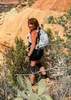
| no partners | | this is the one i couldn't wait for. modified the Bruce/Joe loop by tagging on some excellent additional trail miles and circling around behind cathedral. there was a big storm front moving in that evening so i knew i was on the clock a little bit for this one.
started off messing around up on the beautiful bell rock. went up the lower chute and decided in the interest of time (ie storm) to call it there, for this trip. i will be back for the top one day. scrambled down and around on courthouse butte. took a minute to figure out the unmarked loop out to the rabbit ears. the way out is a bit of a rocky slog, but once you hit the high point, loop around to magnificent view of the rabbit ears and bring it home on the much more entertaining northern leg, this becomes a much more worthwhile excursion!
scenic traverse on llama and little horse over to chicken point for the next high yield part of the hike. views from chicken point are always wonderful. broken arrow is great, then the absolutely fantastic high on the hog and hog heaven trails. man i love these two trails. completed the loop around the mountains on hog wash, mystic and chapel trails. headed back to 179 then crossed under it on little horse and the surprisingly nice HT trails.
next up was probably my most anticipated part of the day looping over to, up/down, then around cathedral. the templeton trail is underrated in my opinion and the segment from HT to cathedral junction, i found to be lovely. this is when the weather really moved in. i contemplated bailing on going up/down cathedral since i've done it numerous times. instead i decided to just put on my bobby rockets and blast up and down. more templeton awesomeness to the creek, then short but sweet crossover on baldwin to the Hiline trail. Folks, we have another sedona winner with the Hiline Trail. completely awesome trail, with sections remniscent of the hogs/hangover. the weather was pretty crazy at this point so i had to keep it moving, but this was really outstanding. i had earlier notions of adding a few extra miles at the end with looping made in the shade and slim shady, but it was pretty clear it was time to call it a day. and i was getting sick of the wind at this point too. ha
outstanding big day out there, without that many people all things considered. my gps screwed up on me for a while on the little horse and broken arrow trails, so the numbers associated with my gps route are not right (a little too low, especially the elevation). for those interested, the route is good though. |
| _____________________
| | |
|
|
|
 Route Editor


 arrows to help guide my way. (I couldn't help but think of the Superstitions and the efforts that HAZ members make to try to keep the Flatiron clean). There was actually rivulets of water streaming down sections of the red rock. But there was enough dry surface to make the climb without slipping. I reached the "end", but continued a little ways further by following a user trail to the east that got me to higher saddle. Views were awesome! Took about 15 minutes taking in the views and then headed back down. Passed about 6 people heading up as I was heading down. No wildlife.
