username
X
password
register
for free!
help
ArticlesGuidesRoutes
 
Photosets
 
 Comments
triplogs   photosets   labels comments more
Shaw Butte Trail #306 - 75 members in 765 triplogs have rated this an average 2.6 ( 1 to 5 best )
1, 2, 3, 4, 5 ... 39  Next
765 triplogs
login for filter options
Apr 07 2025
avatar

 Routes 46
 Photos 253
 Triplogs 47

19 male
 Joined Aug 13 2023
 Phoenix, AZ
Shaw Butte Trail #306Phoenix, AZ
Phoenix, AZ
 Hiking avatar Apr 07 2025
diabloTriplogs 47
 Hiking4.45 Miles 997 AEG
 Hiking4.45 Miles      49 Mns   5.45 mph
997 ft AEG
 
1st trip
Linked   none no linked trail guides
Partners none no partners
Route Scout Route Recorded  on Route Scout | Pop | Map | Popup | MapDEX
 
Apr 05 2025
avatar

 Routes 46
 Photos 253
 Triplogs 47

19 male
 Joined Aug 13 2023
 Phoenix, AZ
N Mountain Shaw Butte Area, AZ 
N Mountain Shaw Butte Area, AZ
 
Mtn Biking avatar Apr 05 2025
diabloTriplogs 47
Mtn Biking5.77 Miles 584 AEG
Mtn Biking5.77 Miles      52 Mns   6.79 mph
584 ft AEG      1 Min Break
 
1st trip
Route Scout Route Recorded  on Route Scout | Pop | Map | Popup | MapDEX
No hike this weekend but wanted to get out for a bit. Went to the mountains in my backyard and it was a great day!
 
Mar 09 2025
avatar

 Guides 21
 Routes 1,183
 Photos 36,909
 Triplogs 1,571

69 female
 Joined Feb 26 2004
 Phoenix, AZ
Shaw Butte Trail #306Phoenix, AZ
Phoenix, AZ
 Hiking avatar Mar 09 2025
tibberTriplogs 1,571
 Hiking4.55 Miles 862 AEG
 Hiking4.55 Miles   1 Hour   55 Mns   2.50 mph
862 ft AEG      6 Mns Break
 
Linked   none no linked trail guides
Partners none no partners
Route Scout Route Recorded  on Route Scout | Pop | Map | Popup | MapDEX
Probably should have done this first rather than Lookout Circumference yesterday. But, I got 'er done. Lots of people out as I mostly kept my head down on the climb. I did have to stop a couple times to rest; something I normally don't have to do. It was a relatively nice day temperature-wise, but I missed Mother Nature's breeze to keep me comfortable.

Instead of going to the top at the intersection, I opted to go down and back up the paved hill; not sure that was the best choice. As I got half way down the hill, I gave myself the choice of going over to the other towers and down around the backside, rather than back up the hill... or back up the hill and down the way I came.... :-k .... back up the hill and the way I came. Once again, normally I don't have to stop on the hill but I stopped four times. I am hoping it's just because I'm still a little out of shape.

On the way back down I was able to test out the zoom on the phone to get pictures of the snow on the Four Peaks and Mount Ord. I just wish I could figure out a way to hold the phone more steady on those zooms; but I did get some decent photos. I zig zagged down the hills as I remember the last time, my shins hurt pretty bad and thot this would help. I took the Dam route to finish off my hike back to Tonto 3 where a Blueberry Wheat beer was waiting for me. It's a great motivator for that last mile :) .

WATCH: 4.52 miles, 2:14-4:09PM, 1379-2102 elevation, 142 avg bpm (a little higher than normal)/163 max, 71% zone 5 max, 20% zone 4 anaaerobic, 10% zone 3 aerobic burning 857 calories (lookout Wendy's Frosty, here I come :D ). Temp 71.5 sunny and 18% humidity, 1.9mph wind from the west.
_____________________
For me, sometimes it's just as much about the journey as the destination.
Oh, and once in awhile, don't forget to look back at the trail you've traveled.
 
Feb 11 2025
avatar

 Guides 10
 Routes 673
 Photos 7,281
 Triplogs 4,660

67 female
 Joined Nov 17 2008
 phoenix, az
Shaw Butte - North Mtn LoopPhoenix, AZ
Phoenix, AZ
Hiking avatar Feb 11 2025
trekkin_geckoTriplogs 4,660
Hiking11.33 Miles 3,119 AEG
Hiking11.33 Miles
3,119 ft AEG
 
Route Scout Route Recorded  on Route Scout | Pop | Map | Popup | MapDEX
john and i modified a loop that @tibber and i did two years ago
got going around 0715
shaw butte first, then over to north mountain, back on trail 100
8 miles, 1800 aeg
coffee during intermission
we were also going to do the loop the @the_eagle did with lookout and shadow mountains recently, but decided to just hit those peaks as stand alone hikes
haven't been on either one in eleven years
up the lookout summit trail then cut down to finish on the circumference trail
1.23 miles, 535 aeg
took the long way around shadow mountain, then down a different route from the summit
2.1 miles, 784 aeg
all good peaks, fun to do something different
el super tacos for taco tuesday after
fun morning, thanks john :)
_____________________
hazhole
  4 archives
Feb 11 2025
avatar

 Guides 1
 Routes 14
 Photos 7,202
 Triplogs 5,208

68 male
 Joined Mar 16 2008
 chandler,az
Shaw Butte - North Mtn LoopPhoenix, AZ
Phoenix, AZ
Hiking avatar Feb 11 2025
johnlpTriplogs 5,208
Hiking11.33 Miles 3,119 AEG
Hiking11.33 Miles
3,119 ft AEG
 no routes
1st trip
Kelly had a plan to hit some peaks in the middle of the metropolis. I had hiked some of these peaks back in 2009. Nothing since, so I was game.
Fun day bouncing around to the different trails and peaks. Great lunch afterwards at El Super Tacos.
Good times. Thanks Kelly! :)
_____________________
“Good people drink good beer.” Hunter S Thompson
 
Feb 07 2025
avatar

 Guides 13
 Photos 15,630
 Triplogs 323

male
 Joined Oct 23 2010
 mesa
Shaw Butte Trail #306Phoenix, AZ
Phoenix, AZ
 Hiking avatar Feb 07 2025
gummoTriplogs 323
 Hiking4.57 Miles 1,228 AEG
 Hiking4.57 Miles   1 Hour   33 Mns   2.95 mph
1,228 ft AEG
 no routes
1st trip
Linked   none no linked trail guides
Partners none no partners
After work hike. I worked in North Phoenix today and preferred to hike instead of facing rush hour traffic.

Afterwards, I went to the gym for a tricep workout. I did biceps last night.
_____________________
  2 archives
Dec 27 2024
avatar

 Guides 7
 Routes 80
 Photos 2,456
 Triplogs 653

34 male
 Joined Jan 10 2010
 Pomona, CA
Shaw Butte Trail #306Phoenix, AZ
Phoenix, AZ
 Hiking avatar Dec 27 2024
PatrickLTriplogs 653
 Hiking2.18 Miles 775 AEG
 Hiking2.18 Miles   1 Hour   28 Mns   1.49 mph
775 ft AEG5 LBS Pack
 no routesno photosets
Linked   none no linked trail guides
Partners none no partners
First hike in about two months. Nice to be outside on a cool day, which seems rare lately.

Headed up via 15th Ave, took a quick break at the old restaurant site on the way down.
_____________________
  1 archive
Dec 24 2024
avatar

 Guides 117
 Routes 339
 Photos 11,415
 Triplogs 895

63 male
 Joined Dec 20 2010
 Sunnyslope, PHX
Shaw Butte Trail #306Phoenix, AZ
Phoenix, AZ
 Hiking avatar Dec 24 2024
kingsnakeTriplogs 895
 Hiking4.56 Miles 878 AEG
 Hiking4.56 Miles   1 Hour   27 Mns   3.14 mph
878 ft AEG
 
Linked   none no linked trail guides
Partners none no partners
It was a wintry — by Phoenix standards — 51° when I started my traditional Christmas Eve day hike up Shaw Butte. The Christmas Palo Verde was a bit barren again this year. Seems like things changed around 2020. 🤔 I should bring some ornaments next year. Anyway, it was good to see an old friend and get in some sorely needed elevation gain.
 Flora
 Flora [ checklist ]
[ checklist ]  Yellow Paloverde
_____________________
http://prestonm.com : Everyone's enjoyment of the outdoors is different and should be equally honored.
 
Dec 10 2024
avatar

 Guides 1
 Routes 1
 Photos 17
 Triplogs 17

31 male
 Joined May 28 2019
 Phoenix
Shaw Butte Trail #306Phoenix, AZ
Phoenix, AZ
Hiking avatar Dec 10 2024
jregan0502Triplogs 17
Hiking3.86 Miles 840 AEG
Hiking3.86 Miles   1 Hour   30 Mns   2.57 mph
840 ft AEG
 no routes
1st trip
Linked   none no linked trail guides
Partners none no partners
 
Nov 28 2024
avatar

 Guides 2
 Routes 208
 Photos 93
 Triplogs 205

male
 Joined Aug 08 2020
 Phx az
Shaw Butte Trail #306Phoenix, AZ
Phoenix, AZ
 Hiking avatar Nov 28 2024
ScaredyCatTriplogs 205
 Hiking4.68 Miles 833 AEG
 Hiking4.68 Miles   1 Hour   46 Mns   3.30 mph
833 ft AEG      21 Mns Break
 
no photosets
1st trip
Linked   none no linked trail guides
Partners none no partners
Route Scout Route Recorded  on Route Scout | Pop | Map | Popup | MapDEX
Did nothing with the fam today so got to the gym on Thanksgiving day for once. Also joined this nearby night hike. Good lil stay busy trek with a small group. Decent climb in the middle. Temps were perf!
 
Aug 04 2024
avatar

 Routes 7
 Photos 240
 Triplogs 19

male
 Joined Nov 24 2023
 Tempe, AZ
Shaw & NoMo & petros, AZ 
Shaw & NoMo & petros, AZ
 
Run/Jog avatar Aug 04 2024
overthehillsfarawaTriplogs 19
Run/Jog
Run/Jog   1 Hour   34 Mns   0.00 mph
5 LBS Pack
 
1st trip
Partners none no partners
Doing a club "scavenger hunt" of sorts this summer. Earned 5 pts for my team with a double summit of Shaw + North Mountain. Intended to check out the petroglyphs but went right by them. Came back after completing the loop. That back side of North Mountain gets pretty steep. Going up isn't so much a problem, but my planned route called for coming back down the same side. Decided to just add a mile or two and take the paved path down.
  4 archives
May 29 2024
avatar

 Guides 7
 Routes 80
 Photos 2,456
 Triplogs 653

34 male
 Joined Jan 10 2010
 Pomona, CA
Shaw Butte Trail #306Phoenix, AZ
Phoenix, AZ
 Hiking avatar May 29 2024
PatrickLTriplogs 653
 Hiking2.00 Miles 756 AEG
 Hiking2.00 Miles      44 Mns   2.73 mph
756 ft AEG
 no routesno photosets
Linked   none no linked trail guides
Partners none no partners
_____________________
 
Apr 17 2024
avatar

 Guides 2
 Routes 251
 Photos 4,593
 Triplogs 3,214

63 male
 Joined Feb 26 2008
 Scottsdale, AZ
Shaw Butte - Western RoutePhoenix, AZ
Phoenix, AZ
Hiking avatar Apr 17 2024
BobPTriplogs 3,214
Hiking4.90 Miles 1,853 AEG
Hiking4.90 Miles
1,853 ft AEG
 no routesno photosets
1st trip
Linked   linked  
Partners none no partners
_____________________
https://www.seeitourway.org
Always pronounce Egeszsegedre properly......
If you like this triplog you must be a friend of BrunoP
 
Feb 24 2024
avatar

 Guides 1
 Routes 226
 Photos 1,675
 Triplogs 1,867

65 male
 Joined Oct 17 2008
 Phoenix, AZ
Funfundzwangzig, AZ 
Funfundzwangzig, AZ
 
Hiking avatar Feb 24 2024
rcorfmanTriplogs 1,867
Hiking24.52 Miles 6,272 AEG
Hiking24.52 Miles   13 Hrs   11 Mns   2.42 mph
6,272 ft AEG   3 Hrs   3 Mns Break
 
no photosets
1st trip
Route Scout Route Recorded  on Route Scout | Pop | Map | Popup | MapDEX
We started later than we would have liked because there is now a gate to the Cholla trail. Somehow the gate opened, and we started. A short ways up, was a Phoenix P&R employee in a truck trying to make us all feel guilty for being in the park off hours. It seems the graceful thing for him to do would be to open the gate instead of playing a self-righteous sheriff of the Camelback Mt fiefdom.

It was strange only needing a headlamp for the very start of the climb up Camelback and for it to be light at the summit. After a short break, we headed down to Echo Canyon TH where we took another short break before continuing through Paradise Valley and over to Piestewa Peak, to the top area where we took a longer break, got water and ate. From there we headed towards Piestewa Peak.

I don't know what was going on with me up Piestewa. I had no strength and was having a terrible go of it. About 2/3 of the way up, at an area with the last bench, I pulled off and sat down for several minutes. I decided to not summit and headed back down to Dreamy Draw. I went pretty slow all the way and got to rest for a while waiting for the others to catch up.

After the rest, I decided to continue with them to North Mountain and decide what to do then. I felt fine on that stretch and was able to complete that section without trouble. Lunch was waiting for us at North Mountain, so there was good food and more rest. I decided to try to complete the rest of the hike. I kept things steady up North Mountain and didn't get too far behind. I was fine from there to the start of the climb up Shaw Butte. Again, I kept things steady and wasn't too far behind to the summit, where we all regrouped before heading down to the North Mountain Visitor Center.

After another rest there, we headed off to Lookout Mountain. It was getting dark on the climb up Lookout and we needed to pull our headlamps out when we reached the steep stuff. We made it to the summit and were happy there was no more climbing, just the descent to the trailhead where Tequila and beer was waiting.

There're two gaps on my route. The first is from where I stopped on Piestewa Peak to close to Dreamy Draw. The second is from the Lookout Mountain summit to the parking lot.
_____________________
Go find a LonelyCache
 
Feb 18 2024
avatar

 Guides 21
 Routes 1,183
 Photos 36,909
 Triplogs 1,571

69 female
 Joined Feb 26 2004
 Phoenix, AZ
Shaw Butte and Cloud 9, AZ 
Shaw Butte and Cloud 9, AZ
 
Hiking avatar Feb 18 2024
tibberTriplogs 1,571
Hiking5.30 Miles 1,014 AEG
Hiking5.30 Miles   1 Hour   57 Mns   2.84 mph
1,014 ft AEG      5 Mns Break
 
Partners none no partners
Route Scout Route Recorded  on Route Scout | Pop | Map | Popup | MapDEX
Today was the day. Shaw Butte is my way to practice elevation, one hill after another and another and another and... well you get the idea. I decided to hike in the AM since it was supposed to be in the high 70s in the afternoon. I think everyone else had the same idea as there were hikers everywhere, plus dogs and some bike riders.

It was a nice morning, altho it felt humid to me as I made my way on the connector trails to get to the first climb. I saw a Starling ontop a saguaro which was an unusual site, the first of two today. I do appreciate that the roadway/trail is so much nicer since this is already a bit of a struggle for me. I noticed some new plants making their way above the ground and as I got up the second hill, yep, I was in Scotland. It was so very green over the valley toward North Mountain.

I continued up the longest hill and finally made it to the intersection with the towers road. Here I would get quite the critter show. I had already seen a couple squirrels and now there were two AND a mouse/rat in the corner near the rock and tree. I don't recall ever seeing a mouse/rat when hiking. I did my best to get pictures of the show they were putting on. After the entertainment I hiked up to the towers and back down.

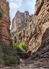
I debated going to the motel but before I could make up my mind, my feet were heading down the direct hill, so I guess I was going; it just took a second for it to register in my brain :lol: . It's a steep but short hill and then I headed to the old motel grounds. Just before getting there I noticed what looks like an alternate road that went down the side of a hill. I have included the photo. I've not seen that before. It is not a trail. If any of you get up that way, see what you think. I just read
Using a Harley Davidson motorcycle and liberal amounts of dynamite, he built two steep, windy roads from where 15th Avenue dead ends to a small peak he had leveled just below the summit of 2,149-foot Shaw Butte.
It would be nice if there could be some sort of plaque up there with the story of Cloud 9.
Customers debarking at the restaurant were greeted by a sign that perhaps only semi-humorously warned, “No Parking: Low Flying Airplanes.”
I headed back knowing I had the "direct" hill to get up but it's short, kind of. I tried to keep my head down so I wouldn't see how far up I had yet to go. I stopped to get a photo of a reborn Desert Lavender plant. I was fairly pleased with my pace up. From here it was clear sailing, other than stopping for photos and admiring my surroundings. There were still so many people out on the trail but I thought that was actually a good thing for their hearts and lungs. I headed to the VC via the dam trail; even that very short distance had hikers, bikers and a dog.

WATCH 10:13AM-12:15PM, 5.20 miles burning 848 calories, elevation 1371-2147. 35% Zone 4 Anaerobic (149-167bpm), 29% Zone 3 Aerobic (131-148bpm), 35% Zone 2 Weight Control (112-130bpm). Starting temp 60.7, sunny with some clouds and 49% humidity (so I was right).
_____________________
For me, sometimes it's just as much about the journey as the destination.
Oh, and once in awhile, don't forget to look back at the trail you've traveled.
 
Jan 27 2024
avatar

 Guides 7
 Routes 80
 Photos 2,456
 Triplogs 653

34 male
 Joined Jan 10 2010
 Pomona, CA
Shaw Butte Trail #306Phoenix, AZ
Phoenix, AZ
 Hiking avatar Jan 27 2024
PatrickLTriplogs 653
 Hiking1.80 Miles 775 AEG
 Hiking1.80 Miles      43 Mns   2.51 mph
775 ft AEG
 no routesno photosets
Linked   none no linked trail guides
Partners none no partners
Up from 15th Ave. Left the trail above 1800ft and took the direct approach up the SW slope. Came down via the use trail on the west side of the antenna equipment. Took 306 the rest of the way down.
_____________________
 
Jan 10 2024
avatar

 Guides 41
 Routes 1,627
 Photos 14,983
 Triplogs 2,762

69 male
 Joined Jan 20 2009
 Far NE Phoenix,
Shaw Butte - North Mountain, AZ 
Shaw Butte - North Mountain, AZ
 
Hiking avatar Jan 10 2024
The_EagleTriplogs 2,762
Hiking8.33 Miles 1,985 AEG
Hiking8.33 Miles   2 Hrs   56 Mns   2.84 mph
1,985 ft AEG2 LBS Pack
 
Route Scout Route Recorded  on Route Scout | Pop | Map | Popup | MapDEX
Thanks to my grandson, I've had the lung funk for the last week and a half. Tired of hacking and only doing flat stuff, it was time to stretch the lungs a bit. I headed for @Tibber territory to hit a few I had not done in 13 years.

Starting from the Shaw Butte TH off of Central Ave, a CCW loop hitting Shaw Butte, North Mountain, crossing the 51, looping The Point Tapatio, back under the 51, past the North Mountain Visitor Center, to my awaiting vehicle.

A tad chilly to start but with shorts and a tee shirt I warmed up quickly on the climb to the top of Shaw Butte. Just a handful of hikers making the climb. Continuing the loop, I stopped at the ruins for Cloud 9 restaurant that burned down back in Nov 1964.

Back down to the valley floor and then I made the climb up the use trail on the west side of North Mountain. It's a decent climb, with the last couple hundred yard being steep and rocky.

Up top I ran into a couple that had just finished activating North Mountain for SOTA. I asked him if that's what he had done and he seemed shocked that I knew what that was.

They've put a lot of time and money into building retaining walls and paving the path down since the last time I was here.

I hopped over the 51, completed my loop around The Point Tapatio and made my way back to the beginning.

I was still hacking, but it felt good to get in something with a bit-o-elevation and mileage.
_____________________
There is a very fine line between "hobby" and "mental illness."
Dave Barry 🦅
 
Dec 24 2023
avatar

 Guides 117
 Routes 339
 Photos 11,415
 Triplogs 895

63 male
 Joined Dec 20 2010
 Sunnyslope, PHX
Shaw Butte Trail #306Phoenix, AZ
Phoenix, AZ
 Hiking avatar Dec 24 2023
kingsnakeTriplogs 895
 Hiking4.12 Miles 773 AEG
 Hiking4.12 Miles   1 Hour   13 Mns   3.39 mph
773 ft AEG
 
Linked   none no linked trail guides
Partners none no partners
From NMVC, my annual Xmas Eve visit to the Xmas Palo Verde. Only person not bundled up like Michelin Man.

Up: 43 min (2.87 mph) ... Non-stop.
Down: 30 min (4.12 mph) ... Jogged the down-y, but not too down-y, parts.

Stopped at Xmas Palo Verde on way back. More decorations than last year, which was just sad, but not to 2015 / 2017 levels.
_____________________
http://prestonm.com : Everyone's enjoyment of the outdoors is different and should be equally honored.
 
Nov 12 2023
avatar

 Guides 21
 Routes 1,183
 Photos 36,909
 Triplogs 1,571

69 female
 Joined Feb 26 2004
 Phoenix, AZ
Shaw Butte Towers Loop, AZ 
Shaw Butte Towers Loop, AZ
 
Hiking avatar Nov 12 2023
tibberTriplogs 1,571
Hiking5.42 Miles 943 AEG
Hiking5.42 Miles   1 Hour   55 Mns   2.90 mph
943 ft AEG      3 Mns Break
 
Route Scout Route Recorded  on Route Scout | Pop | Map | Popup | MapDEX
Today was my test. I passed. I last did it in June. I have to say, it's certainly not a fun hike and makes me realize I'm getting older and it's getting harder but I was determined; even though it would be much easier to turn around after the first two hills. Coming back from that nearly two month hiatus of not doing substantial hikes is much more difficult than I could have imagined.

Lots of people out so that causes a nice distraction. One drone, two lizards, one squirrel. The Shaw Butte Towers were making noise with the wind blowing through those things attached to the towers. Visited the restaurant; still impressive. The North Mountain Towers were buzzing while I was hiking back through the valley, not sure why. Phone quit at 3/4 mark, must have not been on the charger all the way. I used my watch's GPS to link with RS to complete the route; although the watch gave me more AEG. After the phone quit, RS had me at Sudan, near the Ethiopian border :lol: .

WATCH 9:55-11:55AM, 5.32 miles burning 645 calories, 1392-2195 elevation, 135 avg bpm/163 max. 50% Zone 5 max, 29% zone 4 anaerobic, 15% zone 3 aerobic. Temp 73.3, sunny, breezy, 23% humidity.
_____________________
For me, sometimes it's just as much about the journey as the destination.
Oh, and once in awhile, don't forget to look back at the trail you've traveled.
  4 archives
Nov 04 2023
avatar

 Guides 1
 Routes 209
 Photos 1,231
 Triplogs 196

male
 Joined Mar 14 2015
 Phoenix, AZ
Shaw Butte Trail #306Phoenix, AZ
Phoenix, AZ
 Hiking avatar Nov 04 2023
astrobrewerTriplogs 196
 Hiking4.01 Miles 821 AEG
 Hiking4.01 Miles   1 Hour   33 Mns   2.70 mph
821 ft AEG      4 Mns Break
 
Linked   none no linked trail guides
Partners none no partners
Route Scout Route Recorded  on Route Scout | Pop | Map | Popup | MapDEX
This hike of the day for the Phoenix Summit Challenge to get the 4th of 5 summits. Definitely getting warm now. Not a very long trail, but quite steep. Worked up a good sweat on the way up. Down was much easier.
_____________________
 
average hiking speed 2.59 mph
1, 2, 3, 4, 5 ... 39  Next

WARNING! Hiking and outdoor related sports can be dangerous. Be responsible and prepare for the trip. Study the area you are entering and plan accordingly. Dress for the current and unexpected weather changes. Take plenty of water. Never go alone. Make an itinerary with your plan(s), route(s), destination(s) and expected return time. Give your itinerary to trusted family and/or friends.

helpcommentissue

end of page marker